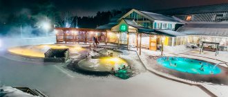
| First day Second day Third day Reviews, tips and routes for tourists Where to stay in Vladivostok Excursions |
Vladivostok is a strange city for tourists. It attracts with its unusualness: its position on the eastern borders of Russia - “the edge of the earth”, its proximity to Asia and its youth. It attracts with the opportunity to be by the sea, indulge in seafood delicacies and admire its expressive city views.
Three days is a good option to get to know Vladivostok in more detail in the shortest possible time, and it doesn’t matter whether it’s in summer or winter. In three days you will be able to calmly walk the streets, see all the sights and study the events of history. You will have time to go to stunning seaside nature and touch its flora and fauna in the best wildlife parks.
Photo: © Natalia Konnova
Below is more information about the most important places in Vladivostok, where to go and what to see for a tourist in 3 days. First, visit the heart of the city, and on the second and third days, go to remote, but also famous sites in the capital and its environs. If the weather disrupts your plans, don’t be upset, this is another integral part of the city. You can easily change the routes and their content, regardless of whether you want to organize a trip on your own or with the help of excursions.
First day
Not visiting the city center, where the main attractions are always located, would be an amazing opportunity. If you come to Vladivostok for three days, you have the opportunity to walk around the streets of the historical center to your heart's content. There is no need to rush to Russky Island or other interesting surroundings: they are worthy of a thoughtful and leisurely visit, there are two other days for it.
Photo: © Elena Yelyakova
Visit the most famous walking spots of the city: Korabelnaya Embankment, Tsesarevich Embankment and Sports Harbor. Walk along the ancient streets of Svetlanskaya, Admiral Fokin - the local Arbat, look into the Millionka quarter and explore every lane, discovering unusual monuments and bright graffiti. Be sure to go up to the Eagle's Nest observation deck and go to the Tokarevsky lighthouse to see the most recognizable landscapes of Vladivostok and its bridges. During your trip, you can also visit museums, find children's entertainment, or simply relax on the city coast, if the weather permits it.
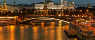
Golden Bridge in the evening Photo: © Oleg Sarapulov
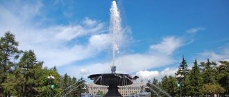
The embankment of the Sports Harbor is one of the favorite and convenient places for recreation for Vladivostok residents. It is decorated with a large fountain and sculptures. The wide promenade is convenient for skiing, and the bay is suitable for a boat trip on a catamaran. The golden sand of the coast attracts everyone who wants to sunbathe. By the way, city beaches usually exclude the possibility of swimming due to the ecological state of the water. In addition to the nearby Yubileiny, the beaches at Cape Kungasny and Patroclus .
Details: beaches of Vladivostok
Embankment of the Sports Harbor Photo: © Anna Kudryavtseva
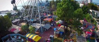
Near the embankment in the Carousel Park there are attractions and a Ferris wheel, which are unlikely to be missed if you come with children. Behind it there is a small aquarium "Aquamir" and the Vladivostok Fortress . You can skip the first one if you are planning to visit a large aquarium (and it is on the list of must-see places). The fortress will be of interest to adults and children who are interested in military history and are happy to explore the fortifications in person.
Where else to go with a child:
Vladivostok for children
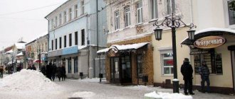
Other embankments can be quickly and easily reached along Admiral Fokin Street . The historical avenue, decorated with old houses, has recently been restored. Now its beginning is a pedestrian street of Vladivostok with recreation areas, fountains, many cafes and shops.
Local Arbat - Admiral Fokin Street Photo: © Irina Lebedeva
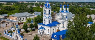
to pass by Revolution Fighters Square either: it is located at the beginning of Korabelnaya Embankment. The square is recognizable thanks to the huge Soviet monument to the Fighters of the Revolution , the tall House of Soviets , where the regional government sits, and the new Holy Transfiguration Cathedral , its construction is almost complete.
Revolution Fighters Square Photo: © Anna Kudryavtseva
The Ship Embankment bears its name for a reason: here you will see many different ships. Don't be surprised by the S-56 submarine standing on land - it's a museum. Opposite her is another ship, the Red Pennant , the deck of which is open to everyone who wants to get acquainted with the atmosphere and technology of the ship. A special sign of the embankment is a memorial stele at the site of the founding of the Vladivostok military camp in 1860.
After the Golden Bridge, the shore continues with the Tsesarevich embankment . There are no attractions on it, but the new children's playground and the width of the promenade are convenient for children to have fun and ride.
Post office on Svetlanskaya Street Photo: © Anna Kudryavtseva
Svetlanskaya Street runs behind the embankments . Vladivostok began with it more than a century and a half ago. Ancient buildings still decorate its appearance. For example, GUM (No. 35) and the Main Post Office (No. 41) are distinguished by their unusual shapes and many details.
At the end of the post office you can find a monument to Eleanor Prey and graffiti with a quote from her letter. The wife of a merchant from the United States lived in the city for several decades, during which time she sent thousands of letters with impressions of Vladivostok. They were later published and made her famous. In addition, on the street there are a large number of administrative institutions, shops, cafes, museums of the History of the Far East and the Pacific Fleet .
Monument to Eleanor Prey Photo: © DK1974
From Svetlanskaya, go up to the observation deck of the Eagle's Nest hill . The easiest way to get there is by cable car ; it itself is a venerable landmark of Vladivostok. From the hill one of the most famous Vladivostok panoramas opens: a view of the Golden Horn Bay with many ships and the supports of the Golden Bridge . The place is beautiful at any time of the day and is a must-see when exploring the capital of Primorye.
View from the lookout on Eagle Hill Photo: © DK1974
Another place that is definitely worth a visit is the lighthouse on Tokarevskaya Koshka . The classic snow-white lighthouse, as it seems to many, is located at the end of a long narrow spit. This is one of the best places to feel the sea atmosphere in reality and then in the photo, see the Russian Bridge from the side. In addition, the road to the lighthouse along the water and a narrow strip of pebbles is a unique experience for many tourists visiting it.
Tokarevsky lighthouse Photo: © Anna Kudryavtseva
See also: What to see in Vladivostok in 1 day Sights of Vladivostok
Walking around Vladivostok, you can meet dozens of heroes - important and funny, immortalized in metal. Many are inextricably linked with the city's maritime history.
- Monument to Muravyov-Amursky , the founder and explorer of the Far East.
Monument to Muravyov-Amursky Photo: © Anna Kudryavtseva
- Monument to A. I. Shchetinina , the former world's first sea captain.
- Monument to Three Whales , in honor of the rescue of animals by Soviet and American sailors in 1988 off the coast of Alaska.
- Monument to S. Lazo , a Soviet leader who distinguished himself during the Revolution and World War I in the Far East.
- Monument to judo fighters of Russia and Japan.
Monument to judokas of Russia and Japan Photo: © Irina Lebedeva
- Memorial to the memory of merchant marine sailors who died during the Second World War.
- Memorial "Fisherman's Glory" with the first domestically produced fishing vessel at the viewing point "on Churkino".
- Monument to Doctor Aibolit.
- Monuments to poets and writers: A. S. Pushkin , A. P. Chekhov , A. I. Solzhenitsyn and V. S. Vysotsky .
Monument to A. I. Solzhenitsyn Photo: © Elena Yelyakova
- Monument to the border guard dog Ingus.
- Monument to the hero Ilya Muromets , the patron saint of the Russian military.
- Monument to a merchant seaman - a young man in the style of the 1970s and 1980s, stopping a car.
Monument to a merchant seaman Photo: © Anna Kudryavtseva
- Neptune sculpture.
- Figures of a dragon, Chinese lions and other symbols of close relations with Asian countries.
- And also many large and small figures of Ussuri tigers.
Sculpture of Neptune Photo: © Elena Yelyakova
If you have time, include a couple of other museums in your itinerary besides those mentioned above. You can make interesting discoveries in them. A visit can be scheduled on any convenient day.
- The sea cucumber museum tells about the mollusk that inhabits the local sea waters. Its appearance can hardly be called attractive, but the bizarre inhabitant has beneficial properties and is a delicacy in the cuisines of Korea, Japan and China.
- The Traveler's House is the house-museum of local historian K.V. Arsenyev, after whom the Museum of the History of the Far East is named. Inside the architectural monument are presented original interiors, things of the researcher and materials about the fate of his family, which fell under repression in the 1930s.
House-Museum of V. K. Arsenyev Photo: © Anna Porotnikova
Leave at least one of the evenings that will be spent in Vladivostok for a cultural program, because the capital of the Primorsky Territory is also the center of the region’s arts. The city has an Opera and Ballet Theatre , Drama Theatre , Philharmonic Society and others.
All theaters in Vladivostok
Opera and Ballet Theater Photo: © Elena Yelyakova
Where to go in Vladivostok with a child
Vladivostok is a wonderful city for families with children: with clean and well-equipped amusement parks, zoos and aquariums, interesting museums and theaters. It is encouraging that many large family entertainment centers and sightseeing attractions have recently appeared, and the city continues to develop.
Thus, in Vladivostok there is a new Einstein Park Museum with interactive scientific exhibits - a branch of the federal network.
There are two aquariums in Vladivostok. In the city center, near the Vladivostok fortress, Aquamir introduces tourists to the marine and river fauna. On Russky Island there is the Primorsky Oceanarium with a Dolphinarium - a huge indoor complex, which you can even spend a whole day visiting with the whole family.
In the summer, amusement parks become centers of attraction in Vladivostok: “Carousel” with a Ferris wheel near the Sports Embankment and “Fantasy” with an entertainment program in the Pervorechensky district.
In good weather, it will be interesting to visit the zoo on Sadgorod, where large animals are kept in outdoor enclosures and have a separate terrarium and poultry house. The zoo also has a petting area where kids can pet ponies, lambs and kids.
The most stellar animals in Primorye - the tiger Amur and the goat Timur - live in the Safari Park near the town of Shkotovo. It will be convenient to go to the Primorsky Safari Park on a weekend or during the holidays, since the distance from Vladivostok is 80 km.
Details: Where to go with a child in Vladivostok
Second day
Vladivostok is not only winding streets running down the slopes of hills, a scattering of houses on them and many bizarrely shaped bays. Vladivostok is much more than just the territory of the city. On the second day, go to the immediate surroundings, which have long become a symbol of Vladivostok itself. By visiting the famous Glass Bay and Russky Island, you will combine sightseeing with exploring the amazing seaside nature.
In the morning you can go to Steklyannaya Bay , which has become famous thanks to its glass pebbles. It is located on the eastern coast of the Muravyov-Amursky Peninsula, ten kilometers from the city. In sunny weather, glass pebbles soaked in sea water will delight you with colorful sparkles - green, blue, white. Among the stones there are fragments of ceramics. The reasons for their appearance in this place are not known for certain; the versions include flooding of glass waste and defective ceramic factory. Guests enthusiastically delve into the “jewels” and take photographs of their finds. In summer, you can sunbathe, swim, and rent a gazebo on the beach, but due to its popularity, it is crowded in good weather.
“Treasures” of Glass Bay Photo: © DK1974
On the way to or after Steklyanukha, fans of automotive rarities can visit the Museum of Antique Automobiles , located on the eastern outskirts of Vladivostok. The collection is small but interesting: it includes well-preserved Soviet cars and motorcycles. The visit will not take much time, but will give pleasant emotions to both adults and children.
A rarity from the Museum of Antique Automobiles on the street. Sakhalin Photo: © Anna Porotnikova
Then follow to Russky Island - the largest in Peter the Great Bay. It lies just a couple of kilometers from the southern borders of Vladivostok. Thanks to the Russian Bridge, the city is conquering new territories. From the 19th century until recently, the island defended Russia from the sea. Now it is a popular tourist destination, combining man-made places of history and recreation with picturesque natural landscapes.
Bridge to Russky Island Photo: © Elena Yelyakova
The Russian Bridge , along which you pass the way to the island, is an important landmark of the city, its symbol, imprinted on the Russian two-thousandth banknote. Its impressive span length and tower height make it one of the most outstanding in the world.
The most popular object on the island is the Primorsky Aquarium . This is a must-have item on the list of every tourist visiting Vladivostok and the island. The huge complex was built just 5 years ago, its interactivity and modernity will captivate even those who are usually not impressed by fish.
Oceanarium, the building is made in the shape of a shell Photo: © Oleg Sarapulov
Hundreds of aquariums, a dolphinarium, colorful models, figures and themed marine areas inside and around the building can be viewed for hours. It’s worth budgeting at least a couple of hours for a trip here.
The Far Eastern Federal University is located nearby. The FEFU embankment is a beautiful park with artificial waterfalls. If it's open, don't miss the opportunity to visit.
FEFU embankment Photo: © Elena Yelyakova
Evidence of past years is the remains of batteries and dozens of forts. For lovers of antiquity, they are an important destination for traveling to Russky Island. Let's highlight a couple of outstanding ones. The Russian Fort on Mount Russkaya is a key position located on the highest hill of the island. It has the shape of a truncated pyramid. The structure of the main barracks is impressive, skillfully combined with the elevation. The views from the fort captivate the relief of the surrounding mountains, filled with emerald vegetation.
The Novosiltsevskaya battery is one of the most convenient to visit. It is located at the exit from the island, with wonderful photos of the Russian Bridge. Unlike many, the monument is in good condition and well maintained. Visitors note a good opportunity to walk, admire the views and climb the fortifications.
Novosiltsevskaya battery Photo: © Elena Yelyakova
Russky Island is even more interesting for those who are not indifferent to nature. The diversity of the coastline, many bays, strange rocks and low mountains covered with greenery will not leave you indifferent. Before the opening of the bridge, this beauty was considered difficult to reach, but now the most interesting places can be reached in half an hour or an hour.
Cape Tobizin and Cape Vyatlina on the southern coast are spectacular natural attractions of Russian. Long jagged cliffs and a raging sea create a truly maritime mood. At the very tip of Cape Vyatlina there is an unusual place - a natural-man-made beach of stones .
Cape Tobizin Photo: © M Marik72
If you come to Vladivostok in the summer and find good weather, you get a pleasant bonus in the form of relaxation by the sea. You can locate on the coast of any bay of the island, but Chernysheva and Novy Dzhigit in the south are in greatest demand. In addition, very close to FEFU and the oceanarium are Ajax beaches and the beaches of Akhlestysheva Bay (Paradise). All of them are semi-wild, conveniences are optional and not all, it is better to provide the necessary things in advance. The beaches of Akhlestysheva Bay on the side of the island of the same name will be convenient for families with children: they are distinguished by vast areas of shallow water.
The beaches on Cape Akhlestysheva from the sea, on the contrary, are famous for their wild waters and winds. Surf camp Swell has been operating there for several years. If you wish, you can rent a board, sup or kayak, take surfing lessons for yourself or a child, or simply stay in the camp with a tent, using its amenities.
If you have time and energy left to see more of the magnificent coastline, go to Shkota Island , which lies south of Russkiy. A dirt road leads to it from the main road, then a ford along a pebble spit 300 meters long. In addition to this option, there is a more convenient and faster option - a boat offered by one of the locals.
Shkota is a small island, despite its size, rich in unreal landscapes. The Shkot coast is decorated with high red rocks, grottoes, arches and kekurs. Once upon a time there were military units here too; their remains can still be found along the route of tourists. The paths along it are simple, they lead to observation points above the rocks, but going down to the shore under some of them is a much more difficult task.
Forests of Russky Island Photo: © Elena Yelyakova
Islands, hills and bays in Vladivostok
Peter the Great Bay - the largest and most picturesque in the Sea of Japan - is famous for its azure bays, fantastic underwater landscapes, clean beaches and rocky capes of unimaginable shapes. But its main wealth is a string of mysterious islands, fancifully scattered among the sea waves. Some of them are famous for their role in the history of the Primorsky Territory, others for their unique, fabulous nature... But both of them are a favorite place for secluded and active recreation for residents and guests of Vladivostok.
Buracheka Hill in Vladivostok
The unofficial name of this hill is Dvugorbaya. This is what the locals called it because of the features of the landscape, reminiscent of a cooled volcano.
This place is loved by creatives of all stripes. Wedding photo sessions are often held here because the view from here is wonderful. Vladivostok residents honor their illustrious ancestors, so the picturesque hill, by the way, one of the highest in the city, was named in honor of the famous lieutenant Evgeniy Burachek, who first commanded the local military port.
The steep slope is helped by a decorative staircase - the work of local craftsmen. In general, many townspeople literally had a hand in this hill. Thus, at the foot of the mountain, thanks to the efforts of activists, a small Japanese-style park has been laid out. The infertile soil was completely replaced by black soil, and soon a floral “polyphony” appeared here.
Address: Pervomaisky district
Cape Vyatlina in Vladivostok
Cape Vyatlina is located on the southeastern part of Russky Island, in Peter the Great Bay. It is located west of Cape Schmidt. This picturesque place got its name in honor of the famous hydrographer - Alexei Petrovich Vyatlin. He was a member of a research expedition (1863-1866), which was involved in drawing up a map of Peter the Great Bay.
Cape Vyatlina is a place that enchants with its rugged beauty. It is composed of high, steep cliffs with inclined layers of rocks. There is practically no vegetation here. Only here and there in early spring does grass emerge. On the western side, the Cape is composed of dark-colored strata, and on the eastern side - yellow. Externally, its structure resembles Cape Tobizin. The reef extends away from it at a distance of almost 270 meters. Drying and surface rocks can be seen throughout the reef.
In 1981, the French frigate Triumph passed near the Cape. Fog and other related weather factors led to the ship running aground. It was removed using port facilities. In 1906, an antique steamship wrecked in this area. His remains are found on the seabed near this site at a depth of about 8 meters.
Cape Vyatlina became accessible to tourists quite recently. It is considered the most remote zone located on Russky Island. Now diving enthusiasts and anyone who is not indifferent to historical monuments can come here.
Address: Russky Island
Russky Island in Vladivostok
There is now a bridge leading to Russky, and it is “open”, but before it was a military base. The island is almost cut by Novik Bay and along the southern shore there are remains of military warehouses, arsenals, and military units. Here is the famous and unique Voroshilov battery - two towers from the battleship Poltava with 305 mm caliber guns.
There’s a whole artillery town here, and while you’re climbing all the floors, you won’t notice how the day goes by. And in the evening you can “shoot from a gun.” A cannon is attached to the main caliber, from which tourists are allowed to “shoot”. Several of the island’s forts are underground casemates dug into the hills with an extensive network of tunnels and galleries. A great place for a walk with the whole family.
Zolotoy Rog Bay in Vladivostok
The picturesque Zolotoy Rog Bay, cut like a blue ribbon into the Muravyov-Amursky Peninsula, conditionally divides Vladivostok, which is spread out on both its banks, into two parts. This is not only the most beautiful place in the city, with breathtaking views, but also the most significant for it: it was with the foundation of a military post on the shores of the bay a century and a half ago that the history of the seaside capital began.
Europe learned about Peter the Great Bay only in 1852, after a certain French whaler was forced to spend the winter in one of its bays, Posiet. It is believed that he was the first to visit the Golden Horn Bay. Four years later, warships from the Anglo-French squadron that searched for Russians during the Crimean War entered here. On the shores of the bay, they discovered a small Chinese settlement, whose inhabitants were engaged in growing vegetables and also caught fish and seafood. At that time, the bay bore the Chinese name - Haishenwei, which translated meant “golden sea cucumber bay”. The British gave it another name - Port May - in honor of Francis May, the navigator of the ship on which they arrived in the Far Eastern bay.
But the bay did not bear this name for long. Already in 1859, the Governor-General of Eastern Siberia Nikolai Muravyov-Amursky, walking around the shores of Peter the Great Bay on a ship, noticed a well-sheltered bay that attracted his attention. He named it the Golden Horn - due to its resemblance to the bay of the same name in Istanbul - and ordered the establishment of a military post called Vladivostok here, which soon turned into a city.
The bay is well protected from most winds, and therefore is a convenient anchorage for ships. Its hilly and steep banks were leveled and expanded, strengthened with walls, and equipped with berths, docks and piers. In the northwestern part of Zolotoy Rog Bay, which is adjacent to the administrative center of Vladivostok, there is a sea passenger port building; There are also commercial and fishing ports off the coast of the bay. The headquarters of the Pacific Fleet and warships of the Pacific squadron are also located here.
Astafieva Bay in Vladivostok
Astafiev Bay is located between Spaseniya and Sivuchya bays on the territory of the Far Eastern Marine Reserve, on the northern shore of the Gamow Peninsula, Peter the Great Bay. Discovered and mapped by the crew of the corvette steamship "America" and the expedition of Colonel K.F. Budogossky in 1859. Named no later than 1897 from the nearby Astafiev Islands (after the surname of the second lieutenant of the corps of naval navigators Ya.T. Astafiev).
Astafieva Bay juts out like a bucket into the shores of the Gamow Peninsula and enchants the transparent bluish sea with the color of the water and the purity of the coastal sand. In spring, the southern shore of the bay is covered with thickets of rhododendron, and then spring itself reigns here in a riot of colors. Astafieva Bay itself is very clean. If desired, from the nearest hill you can see its bottom even in those places where the depth reaches ten meters.
The bay has a sandy bottom with clean white sand. The depths in the bay increase gradually, which makes it a great place for a family vacation in the summer. Along the paths along the coast of the bay you can take fascinating walks to the tops of the surrounding hills, where you can take photos of the Primorsky Territory with views of magnificent seascapes. The shores of the bay are extensive; a leisurely walk along the shore can be alternated with a swim in the turquoise water.
Astafieva Bay is one of the most popular and easily accessible bays of the peninsula. Despite the fact that its water area is part of the protected zone of the Far Eastern State Marine Reserve, on the shore in the summer there is a pilgrimage of nearby tourists who understand sandy beaches.
Rikord Island in Vladivostok
Rikord Island in Peter the Great Bay is located 32 km south of Vladivostok. The island consists of two parts, northern and southern, connected by an isthmus. The island stretches from the square to the south for 4 km, from west to east the width of the island reaches 2 km. The maximum height of the island's surface above sea level is 178 meters. The northwestern coast of the island is decorated with red and black rocks and pebble beaches with large boulders. The south-eastern coast is high, its banks are steep and rocky. Vostochnaya Bay is famous for its gorgeous sand and pebble beach.
Rikord Island was surveyed and mapped in 1862-1863 by a hydrographic expedition of Lieutenant Colonel of the naval navigator corps V.M. Babkin. and named “Rikord Island” after the name of the director of the Hydrographic Department of the Maritime Ministry, Admiral Pyotr Ivanovich Rikord, navigator and explorer, statesman.
Much of the island's surface is overgrown with dense and sometimes impenetrable deciduous forest, consisting primarily of oak and linden. The forest alternates with clearings densely overgrown with bushes. In the forest there are dimorphant and aralia, Amur grapes and lemongrass, Actinidia kolomikta and barberry, rhododendron and rose hips. Part of the island’s territory is occupied by meadows, where entire glades of irises, lilies, and bells bloom.
Rikorda Island is a wonderful holiday destination thanks to the unique nature of the island, clear water, and magnificent beaches. During the summer season, a tent camp and children's camp operate on Rikorda Island.
Cape Tobizin in Vladivostok
Cape Tobizin is the eastern entrance cape of Novy Dzhigit Bay on Russky Island. It is located on the territory of the Vladivostok urban district, at the tip of the peninsula, also called Tobizina. From the east, the peninsula is washed by the waters of Karpinsky Bay, and from the west by Ostrovnaya and Novy Dzhigit bays.
Cape Tobizin on Russky Island is perhaps the most visited place by residents and guests of Vladivostok, which cannot simply be reached by car. The road to the cape from the nearest makeshift car park takes about half an hour of leisurely walking, but this does not stop lovers of beautiful rocks and the sea, bright sunrises and sunsets, hiking trails, picnics and barbecues. Even cold weather does not deter visitors to this cape.
Popov Island in Vladivostok
The native name of the island is Mama-sakha, meaning “Black Coast under a Lone Star.” The island is rich in beaches. Here is the northern section, the educational zone of the Far Eastern Marine Reserve. On the island there is a museum “Nature of the Sea and Its Protection”, a center for environmental education, and the Island Botanical Garden.
The top of the island is Popov Hill, 158.5 m high.
Popov Island is located almost in the very center of Peter the Great Bay, on the crest of an underwater hill, seven kilometers long. The surface is mountainous, but the mountains are low, smooth, and covered with forest. The coastline is represented by sandy and pebble beaches, alternating with rocky cliffs. There are two villages on the island - Stark and Popova.
Helena Island in Vladivostok
Helena Island is located in Peter the Great Bay. It is separated from the central part of Vladivostok by only 6.5 kilometers. The island is an administrative unit of Vladivostok and belongs to the Frunzensky district. From different sides the island is washed by the waters of Novik Bay, Amur Bay and the Eastern Bosphorus Strait.
Helena Island is an artificially created island. Initially, it was the extreme part of the Saperny Peninsula and was called the Larionovsky Peninsula. The beginning of the life of the island can be considered in 1897, when builders began laying the future canal. The formation of the island was carried out over two years from 1897 to 1899. It was at this moment that construction work on laying the canal was carried out. The forces of the 1st and 5th line battalions were assigned to the work. The project for the work was developed by military engineer Captain Romanovich. The authorities, without thinking twice, named the resulting plot of land in the Gulf of Peter the Great - Larionovsky. A little later the island was renamed Helena Island. According to various facts, it is known that this was the name of the daughter of the owner of a brick factory located on the territory of Russky Island.
The newly formed island had an area of just under 145 hectares. The maximum point above sea level is at an altitude of 99 meters. There is no permanent population. In 1930, a radio engineering unit was located on the island, but it was closed in 1986. Access to Helena Island was restricted until 1996. At the moment no one lives there.
Steklyannaya Bay in Vladivostok
A unique place is Steklyannaya Bay in Vladivostok. The uniqueness of the bay is that it is strewn with pieces of broken glass; in fact, it is a glass beach, on which sand, glass and pebbles are mixed. Unfortunately, the uniqueness of this bay is the result of human pollution, because... Once upon a time these beautiful pieces of glass were ordinary bottles.
There are two versions of the history of the formation of Steklyannaya Bay in Vladivostok: the first says that two trucks with bottles were once dumped on the beach, the second version is that a kilometer from the beach there was a landfill for household waste, Ermine, which was located on the eve of the APEC 2012 summit cultivated and closed, the bottles from this landfill were carried out towards the beach by the current and smashed against the rocks, and thus Steklyannaya Bay was formed.
Lazurnaya Bay in Vladivostok
The picturesque Lazurnaya Bay - with its large sandy beach, healing air, stunning sea landscapes and developed infrastructure - deservedly enjoys the status of one of the most popular recreational areas where Far Easterners and guests of the seaside capital love to spend time. Located in the Ussuri Bay, washing the eastern coast of the Muravyov-Amursky Peninsula, on the hills of which Vladivostok is located, it is one of the most romantic symbols of the Primorsky Territory.
Until the end of the twentieth century, the bay was called Shamora, which means “sandy desert” in Chinese. She got this name back in the days when Primorye, according to an agreement, was jointly used by China and Russia. But in 1972, due to a noticeable cooling in Soviet-Chinese relations, all geographical names in the Russian Far East were replaced by Russian ones - at the same time Shamora Bay turned into Lazurnaya. But local residents, nevertheless, continue to call it in the old fashioned way - Shamora.
The shores of the bay are sandy and shallow, and its surroundings are a lowland covered with meadow grasses and shrubs, which is framed like an amphitheater by forested hills. One of them hides one of the most secret objects of the Primorsky Territory - a closed command post of the Pacific Fleet with a huge electronic map of the world. And along the tops of the coastal ridge runs the so-called Tiger Trail, along which, according to local residents, tigers used to walk into the city.
Reineke Island in Vladivostok
Reineke Island lies in the waters of Peter the Great Bay south of Russky Island; a shallow and narrow strait separates the island from Popov Island. The length and width of the island are approximately equal - 3.0-3.5 km. The strait separating the islands of Reineke and Popov is shallow, up to 3 meters deep, the fairway is winding, the width of the strait is up to 500 meters. The wide and deep Amur Strait (the old name is the Japanese Strait) separates Reineke Island from Rikorda Island.
The island is a small hill, the maximum height is Mount Reinecke, 149 meters, with hilly terrain and individual heights of 30-70 meters. The coast of the island has both rocky and beach areas. In the southern part of the island there is a ridge of surface stones, the red color characteristic of Peter the Great Bay. To the southwest of the ridge, at a distance of 3 km at a depth of 2.5 meters, there is an underwater rock. A small islet 41 meters high lies to the east of the island. There are lagoons and lagoon lakes. The length of the island's coastline is just under 12 km.
Reineke Island was surveyed in 1862-1863 by a hydrographic expedition of Lieutenant Colonel of the naval navigator corps V.M. Babkin. and named “Reineke Island” after the director of the Hydrographic Department of the Maritime Ministry, Admiral Reineke M.F. It was studied in more detail in 1885 by Maltsev A.A.
At the end of the 19th and beginning of the 20th centuries, there was a small village on the island, which was inhabited by Russian civilians, Koreans and Chinese. The main occupation of the population was fishing, raising livestock, and gardening. Reineke Island, as well as Popov Island, was used in the period 1905-1907 to remove the dissatisfied; the commanders of the Vladivostok fortress sent the dissatisfied and unreliable here in the summer.
The natural landscapes of Reineke Island are very picturesque. There is very little forest on the island, it is protected and preserved. The residential village is located in the northern part of the island, and the most convenient for recreation is its western part. The sloping slopes of the western coast smoothly approach the sea, forming a pebble and sandy beach, the width of which is 1-3 meters. This is a favorite accommodation for tourists arriving on the island.
Askold Island in Vladivostok
Askold Island is located in Peter the Great Bay at approximately equal distances from both Vladivostok and Nakhodka. The rocky shores of the island drop steeply to the water, and only on the northern side, in the area of Cape Strelchaty, is there a flat section of the coast on which you can safely land.
The Askold Strait separates Askold Island from the mainland and Putyatin Island located to the north. The area of the island is 14.6 km², and the maximum height above sea level reaches 358 meters. On the southern side of the island there is a deep closed bay called Nayezdnik, thanks to which the outline of the island resembles a horseshoe.
On the island you can see sika deer, which graze freely here. At the end of the 19th century, exiled settler Mikhail Yankovsky, a Pole by birth, served as manager of the gold mine. It was M. Yankovsky who began breeding sika deer on the island. Over the course of 10 years, the nursery bred more than 2 thousand deer. The island was a favorite hunting spot.
Putyatin Island in Vladivostok
Luxurious nature, unusual, rugged terrain, rocks reminiscent of exotic animals, clear sea, amazing underwater world, sandy beaches and historical monuments - all this attracts numerous tourists and photographers to Putyatin Island. The pearl of the island is considered to be Goose Lake or Lotus Lake, as locals and tourists call it.
Once upon a time, the grandson of the Decembrist Bestuzhev, Alexey Startsev, founded a family estate here on the island. A talented entrepreneur planted orchards and built a porcelain factory, the products of which were known throughout the world. A lot is connected with his name here: the highest mountain, from which in good weather a beautiful view of Askold Island opens, and Vladivostok, and the cape that welcomes tourists who decide to visit this beautiful island.
Klykov Island in Vladivostok
Klykov Island is an island in Peter the Great Bay in the Sea of Japan. It is located approximately 2.6 km southeast of Popov Island and 22 km southwest of Vladivostok.
Klykov Island, 52.2 m high, lies 1.8 kbt S from Maly Island. From the S, Klykov Island is noticeable by two hills located in its southern part. The shores of Klykov Island, with the exception of the northwestern one, are rocky, steep and bordered by stones. The surface of the island is overgrown with bushes. The northwestern coast is sandy, with stones and rocks scattered on it. The northern tip of the island is a low spit, which is approached by an underwater spit coming from Maly Island.
Pakhtusov Islands in Vladivostok
A group of small uninhabited islands in Peter the Great Bay, lying southwest of Reineke Island and west of Rikord Island, is called the Pakhtusov Islands. Small islands, there are only 3 of them, are surrounded by rocks. All the islands lie on the same underwater rocky ridge.
The Pakhtusov Islands are named after the explorer of Novaya Zemlya and the White Sea, Pakhtusov’s second lieutenant Pyotr Kuzmich (1800-1835). In 1862, when the First Hydrographic Expedition led by V.M. Babkin. led the study of Peter the Great Bay, marking the 30th anniversary of Pakhtusov’s expedition to the island of Novaya Zemlya. In honor of the brave Russian sailor, explorer of Novaya Zemlya Pakhtusov P.K. and his assistants, Babkin V.M. gave the islands of the archipelago the names of Lieutenant V.A. Krotov. and Tsivolko A.K., conductor of the corps of naval navigators.
On the Pakhtusov Islands in the 30s of the twentieth century there was a women's camp. The nuns, who were sent to the Far East in stages from central and central Russia to work in the “fishing” zone, served their time in the camp and died quietly. On the shore of the island, vats for salting fish still remain from those times.
The rocky islands of Pakhtusov are covered with dense bushes and deciduous forest. The bush thickets in the central part of the island are almost impassable. Pebble beaches stretch along the southern and western coasts of the islands; There are sandy areas on the northern and western coasts. The western coast of the island is steep and rocky, the coast is rocky. A magnificent deep and sheltered bay located on the south coast of the large island.
Zheltukhin Island in Vladivostok
Zheltukhin Island is the southernmost island of the archipelago of islands stretching across the waters of Peter the Great Bay from Vladivostok to the south. To the south of Rikord Island there are several small uninhabited islands, including the Moiseev and Zheltukhin islands. Zheltukhin Island lies south of Moiseev Island and is easily recognizable due to its reddish-yellow exposed rocks. The southern coast of the island is rocky and steep. In the western and eastern parts of the island there are small hills that are separated by a shallow saddle. The height of the western, higher hill reaches 75.1 m. The southern slopes of both hills are steep and steep, and the northern slopes are gentle, smoothly descending to the shore of the bay jutting into the island.
In 1863, the hydrographic expedition of Lieutenant Colonel Babkin put the island on the map of the Amur Bay under the name “Zheltukhin Island”. The island was named in honor of captain-lieutenant Fyodor Nikolaevich Zheltukhin, who commanded the corvette Kalevala. The officers and sailors of the corvette carried out boat soundings, compiled descriptions of the islands of the southern part of the Amur Bay, including the western part of Peter the Great Bay, from Cape Gamow to the Tumangan River, the western coast of the Muravyov-Amursky Peninsula, the Rimsky-Korsakov Islands, and carried out boat soundings in the Slavic Gulf and Holy Trinity Bay, near Cape Gamow. According to the tradition of the discoverers, the officers of the hydrographic expedition decided to give one of the islands the name of Captain Zheltukhin.
The island was uninhabited for a long time. But in the second half of the twentieth century, it was decided to turn it into one of the hubs of Vladivostok’s coastal defense. Several heavy IS-2 tanks were stationed at the island's training ground, with rotating tank turrets and a projectile range that covered 20 kilometers. Thus, Zheltukhin Island turned into a reliable shield on the sea approaches to Vladivostok.
The third day
Another day in Vladivostok is a reason to visit its other remote attractions - Safari Park, Botanical Garden, as well as interesting sites along the way. It is difficult to visit all the places described below in one day, despite their location in the same direction, north of the city, and it is not at all necessary, although each is worthy of a visit. Therefore, choose 3-4 items according to your preferences.
Interestingly, despite the distance of about 80 km to the Safari Park and its location in another area, it is also a top place that is definitely recommended to visit in the capital of Primorye. The Safari Park is unique in many respects. It is home to seventy species of animals living in the Primorsky Territory, including rare, red-listed and extinct animals. Among them are three Amur tigers, two Far Eastern leopards, Himalayan bears, forest cats, large birds of prey and dozens of other smaller inhabitants. The park is vast and features a varied natural landscape. The animals appear without bars, essentially among the forest and rocks. Special high bridges have been erected for human inspection. Even those who do not visit regular zoos out of pity for the animals are delighted with the visit.
Leopard from Primorye Safari Park Photo: © DK1974
Another wildlife museum-park will be on the way to the first one - the Sadgorod Zoo . In it you can also meet tigers and leopards, graceful spotted deers, powerful yaks, funny lemurs, meerkats and almost 60 other species of animals. All of them ended up in “Garden City” for various reasons: some were left without a mother, others would not have survived in the wild due to illness, or were already born in the park. Young guests are always happy to feed farm animals or ride ponies and horses, which can also be done here. In the summer, those interested can purchase emu or African ostrich eggs.
You can feed the sika deer in the Safari Park Photo: © Natalia Konnova
The Vladivostok Botanical Garden will continue the theme of wildlife in the same direction . It is located along the main road leading out of the city, in the Sanatorny microdistrict. For those coming from other regions, getting to know the flora of the Far East can be a fascinating process, since many species are not typical for the vegetation of central Russia. Walking along the eco-trail, you will touch relict black fir and oak forests with centuries-old representatives, in the arboretum you will meet imported representatives from all over the world, in the summer you will admire the colors of magnolias, roses, lilies and irises, and in the greenhouses you will see heat-loving representatives of the flora.
Rhododendrons from the Vladivostok Botanical Garden Photo: © Vera2012
If your trip to the capital of the Primorsky Territory falls in mid-July - August, you have a rare opportunity to catch the lotus blooming. The delicate pink flower grows in only a few regions of Russia, and one of them is Primorye. A convenient place to admire the blooms is Lotus Lake Karasinoye . It is located near the state district power station of the city of Artyom, not far from the road to the Safari Park mentioned above.
Lotus Lake near the city of Artem Photo: © Vera2012
Just a kilometer from the zoo on “Sadgorod” there is the Museum of Historical Technology . If you come with a child - a boy, visiting him will add variety to your trip to natural sites. A large collection of vintage cars and the opportunity to sit in the interior of some of them makes a great impression on the guys. There is a lot of equipment: Soviet and foreign passenger cars, army cars and motorcycles, trucks and armored vehicles, representative cars for the country's leaders, as well as artillery pieces, items from the Second World War and home appliances from the times of our grandmothers. The exhibition is quite extensive; if you are particularly interested, you will need at least a couple of hours to study it.
In the same direction there is a special natural attraction where Vladivostok residents go on weekends - Shkotovsky waterfalls , namely the first of them - Unexpected (Humpbacked) . A stream ten meters high seems to fall in steps from huge rock ledges. It is surrounded by a stunning forest with ferns and mosses, creating a picture of the grandeur and purity of nature. In winter it is also accessible, but appears as a huge ice wall. This waterfall is just one of the few in the Primorsky Territory. It will take a little time to visit it if you are already driving in this direction, since you can drive quite close to it with a passable car.
Unexpected Waterfall Photo: © Dimasigida12
Top 6 views of Vladivostok: the best places for your photos
In the city on the hills, finding a vantage point is not difficult. Turned the corner, climbed a staircase or path hidden among the houses, turned towards the sea - and looked with all your eyes.
True, the view may not be exactly the bay or the red sunset. There is always a chance to find garages with right-hand drive foreign cars somewhere below or a sparkling, tall new building right in front of you.
To prevent the search for species from turning into a course of cardio training on the city streets, study the selection of the main observation platforms in Vladivostok. The BB correspondent has collected locations that tourists do not miss.
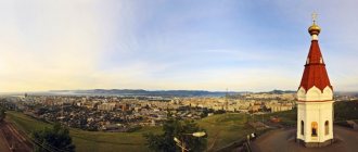
Sopka Burachka
If you want to turn a walk to the view into an adventure or even a hike, go to Burachka Hill. It is located far from the city center, the path up is not landscaped, and you can often find stray dogs below. But the view is magnificent, especially in the dark.
Photo by: Alexander Khitrov
Geography: the hill is located in the southern part of the city between the Golden Horn, Diomede and Ulysses bays. Address of the landmark house: Tereshkova, 5. The height of the hill is 138 meters.
In the frame: a circular panorama of the city center, Zolotoy Rog Bay, part of the Pervomaisky district.
Infrastructure: the path to the top can be called difficult. You won’t be able to get to the very top by car; the climb from the road is steep and rocky. It is better to take care of comfortable shoes.
Photo by: Alexander Khitrov
Eagle Nest
The most famous viewpoint in Vladivostok is named after the hill on which it is located. This is where the “classic” photographs of the Golden Bridge were taken.
On the site you can take a photo with the monument to Cyril and Methodius in the background. This is a sculpture depicting two brothers with a cross and an alphabet in their hands.
Photo by: Alexander Khitrov
Geography: the Eagle's Nest observation deck is located next to the upper station of the funicular. The height of the hill is 199 meters.
In the frame: the Golden Horn and the Golden Bridge, the city center, the seaport, the railway station. The best time for photography is at dawn and at night.
Infrastructure: This place was once a tourist mecca, but now looks abandoned and dilapidated. Be careful when visiting, do not lean on the fences.
Photo by: Alexander Khitrov
Sopka Krestovaya
Another point where you can often meet photographers is Krestovaya Hill. Tourists and locals come here less often, because the place is located far from the center.
At the top of the hill there is a cross and a concrete sign with an inscription that they planned to erect a monument to Lenin here - more precisely, his huge statue, but the idea was not realized.
Photo by: Alexander Khitrov
Geography: Krestovaya Sopka is located in the area of Saratovskaya and Roznichnaya streets, not far from the Krygina stop. The climb is not difficult, but it is better to leave your heels at home.
In the frame: Peter the Great Bay, Skrypleva Island, the bridge to Russky Island, the Goldobin Peninsula, the Shkota Peninsula itself. From above you can see ships entering the port.
Infrastructure: the place is still wild, but recently there has been a sign at the top announcing that a landscaped viewing platform will appear here. Just below the top you can walk through a decorative labyrinth made of stones.
Photo by: Alexander Khitrov
Seaport
One of the few observation platforms where you don’t have to climb, taking your breath away. You just need to go out to the sea and enjoy the views - either of the Golden Horn and the bridge, or of the arriving ship.
Photo by: Alexander Khitrov
Geography: the sea terminal is located in the very center of Vladivostok, next to the railway station and the square.
In the frame: Golden Bridge and Golden Horn. Cruise ships often come here and are popular with tourists.
Infrastructure: on the site behind the seaport there are benches, there are many shops and cafes inside. The building houses the tourist information center of the Primorsky Territory, where city guests can pick up a city map and booklets for free.
Photo by: Alexander Khitrov
Rotunda
Soviet photographs of Vladivostok often feature views from the rotunda on the embankment in Sportivnaya Harbor. The frame includes a Ferris wheel, a walking area and the sea.
Photo by: Alexander Khitrov
Geography: the rotunda is located next to the Ocean cinema. Below is the Yubileiny beach with a walrus club in winter and night bars in summer.
In the frame: nothing has changed - you can see the beach, the attractions and the embankment itself.
Infrastructure: the place is easy to access; benches are installed in the rotunda itself. Nearby there is almost everything that can please city guests.
Photo by: Alexander Khitrov
Square named after Anna Shchetinina
Another place where it’s nice to enjoy the proximity of the sea, watch sea navigation and watch sunrises is the park named after the first female sea captain Anna Ivanovna Shchetinina.
Photo by: Alexander Khitrov
Geography: the viewing platform is located at the address: Krygina, 80 on the Shkota Peninsula.
In the frame: a panorama of the Golden Horn Bay and the wide expanses of the Amur Bay.
Infrastructure: here you can sit on a bench and take a selfie with a bust of Anna Ivanovna by Vladivostok sculptor Timur Nesterovich. The square is located near the bus stop.
Photo by: Alexander Khitrov
Reviews, tips and tourist routes
In three days in Vladivostok, guests have time to get acquainted with most of the city's calling cards, explore the sights of the surrounding area and even visit other cities of the Primorsky Territory. A three-day trip often becomes a continuation of a larger trip to eastern Russia and complements a visit to Kamchatka, Sakhalin or the Khabarovsk Territory, since some airlines connect their flights in Vladivostok.
The following reviews from tourists will introduce 3-4-day routes around Vladivostok:
- “Mists, hills, campus, ships and lighthouses on the edge of the earth” from Anna Porotnikova;
- “Road trip through the Far East, part 1 - Primorsky Territory” from Dmitry;
- “The land where the wind bends the pillars - Vladivostok” part 1 and part 2 from Natalia Konnova.
Be sure to check out the main city page , where you will find useful information about transport, weather, hotels, and advice on what to bring from Vladivostok .
All tourist reviews about Vladivostok on Tourist. RU
Where to stay in Vladivostok
Vladivostok offers a large selection of accommodation available for tourists and business travelers: hotels up to 5 stars, apartments, as well as modern hostels and capsule hotels, which are rare in any capital of the Russian Federation. A significant part of the hotels are 3-star options. The range of housing in terms of freshness, comfort and price level is wide, so you will certainly be able to choose the option that suits you.
Photo: © Elena Yelyakova
Vladivostok boasts attractive views not only from observation platforms. There are enough options here where you can see the sea and admire the best city landscapes right from the window of your room or apartment. While you are enchanted, do not forget: on the eastern side, along the coast of the Amur Bay, the city stretches for tens of kilometers, and the optimal location for a tourist would be closer to the central part, located near the Golden Horn Bay.
- Vladivostok Hotels
- Hostels for Budget Travelers
- Flats and apartments
Pay attention to the bonus when booking accommodation with Booking.com: Cashback promotion for Tourist. RU
What to see in Vladivostok is a must
Despite the fact that the city cannot boast of a very long history, there is a lot to see here. In this section you will learn about the main attractions of Vladivostok, which you should see first.
Golden Bridge
- Address: Between Korabelnaya Embankment and the port.
Connecting the shores of the Zolotoy Rog Bay with a bridge became an urgent necessity for the rapidly developing Vladivostok at the beginning of the last century. The question of building an engineering structure was raised both during the monarchy and during the period of developed socialism, but the plans were not destined to come true only in the present century. The implementation of the grandiose infrastructure project, which ended with the grand opening of the bridge on August 11, 2012, took about 4 years.
The size of the structure is amazing. The length of the bridge is slightly more than 1388 m with a width of about 33 m. Its nine spans are held by the strongest steel ropes passing through pylons rising 226 m above the grillages. The structure can withstand a magnitude 8 earthquake and winds blowing at a speed of 47 m/s. For all its massiveness, the cable-stayed bridge, which has become one of the symbols of the city, looks surprisingly elegant.
Nikolaevsky triumphal gates
- Address: Admiralsky Square. Transport stop "Lazo".
The stunningly beautiful structure is an exact copy of the gate, erected from stone and brick in 1891, for the arrival of the future Emperor Nicholas II, who then bore the title of Tsarevich, to the city. The architectural monument, blown up by the Bolsheviks in 1930, was reconstructed 77 years later.
An elegant two-tier structure in a lush Russian-Byzantine style with a hexagonal cone-shaped dome, the spire of which is crowned with the Russian coat of arms, and has through arched passages. The façade of the gate is decorated with small columns with amazing capitals and carved pediments.
On four sides of the second tier there are niches, reminiscent of church kokoshniks in shape. In a niche above the front side of the façade there is an image of St. Nicholas the Wonderworker, considered the main patron of sailors, and in the other three are the coats of arms of the fortress, the Primorsky Territory and modern Vladivostok.
Train Station
- Address: st. Aleutskaya, 2. Transport stop "Railway Station".
The Vladivostok railway station became the end point of the most ambitious infrastructure project of the Russian Empire - the Trans-Siberian Railway. The main station building was built in 1893. Due to the increased volume of passenger and freight traffic, it was reconstructed in 1912 by adding portals. At the same time, the building acquired a second floor.
In the exterior of the building, which attracts with the visual lightness of the composition, the features of the capital's Yaroslavl station, in the image of which it was built, are clearly discernible. On the platform you will see a bronze kilometer pole mounted on a granite pedestal, topped with a double-headed eagle with the numbers 9228. This is the distance covered by passengers traveling from Vladivostok to Moscow along the Trans-Siberian Railway.
Monument to G.I. Nevelsky
- Address: st. Svetlanskaya, 56. Transport stop "Lazo".
The monument to the remarkable Russian admiral, who made an invaluable contribution to the development of Russian geographical science, has long been the main symbol of Vladivostok. Although Gennady Ivanovich himself had never been here, the townspeople decided to perpetuate the memory of the scientist and traveler, who did so much for the development of the Far East.
Under the foundation stone there is a silver memorial plaque placed there by the future Autocrat Tsarevich Nicholas. The obelisk made of granite blocks in the shape of a truncated pyramid is crowned with a bronze figure of a double-headed eagle standing on the globe and spreading its wings over it. In arched niches on four sides of the marble base you will see a bas-relief of the admiral and memorial plaques describing the great geographical discoveries he made.
Monument to the heroes of the Russo-Japanese War
- Address: st. Svetlanskaya, 66. Territory of the Pacific Fleet Museum. Transport stop "FEGTU".
In Soviet times, it was somehow not customary to talk too much about the events of the Russo-Japanese War of 1904-05. Mentions of it were often limited to only a description of the feat of the sailors of the cruiser “Varyag” and the gunboat “Koreets”. Meanwhile, the residents of Vladivostok sacredly honored the memory of many other soldiers of the Russian army who fell at that time. Therefore, it is not surprising that in 2006 a monument to heroes appeared in the city.
In front of the semi-oval portico, supported by three square columns, there is a pedestal trimmed with polished red-brown granite tiles. On it is placed a bronze figure of an archangel with a shield, clutching a sword in his hand. The black granite slab at the base contains a commemorative inscription.