For the river in Russia, see Kargat (river).
City in Novosibirsk region, Russia
| Kargath Kargath | |
| City [1] | |
| Kargat railway station | |
| Coat of arms | |
| Location of Kargat | |
| Kargath Location of Kargat Show map of Russia Kargath Kargat (Novosibirsk region) Show map of Novosibirsk region | |
| Coordinates: 55°11′44″N 80°16′52″E / 55.19556°N 80.28111°E / 55.19556; 80.28111 Coordinates: 55°11′44″N 80°16′52″E / 55.19556°N 80.28111°E / 55.19556; 80.28111 | |
| A country | Russia |
| Federal subject | Novosibirsk region [1] |
| Administrative region | Kargat district [1] |
| Town | Kargat [2] |
| Height | 130 m (430 ft) |
| population size (2010 Census) [3] | |
| • General | 10 042 |
| • Evaluate (2018) [4] | 9370 ( -6,7% ) |
| Administrative status | |
| • Capital from | Kargat district [1], Kargat city [2] |
| Municipal status | |
| • Municipal district | Kargat municipal district [5] |
| • Urban village | Urban settlement Kargat [5] |
| • Capital from | Kargat municipal district [6], urban settlement Kargat [5] |
| Timezone | UTC+7 (MSK+4[7]) |
| Postal code [8] | 632400, 632402 |
| OKTMO ID | 50619101001 |
Kargath
(Russian: Kargat, Kazakh: Karaqit,
Qaraqat
) is a city and administrative center in Kargatsky District in Novosibirsk Oblast, Russia, located on the banks of the Kargat River. Population: 10,042 (2010 census); [3] 11,184 (2002 census); [9] 12,561 (1989 census); [10] 12,600 (1979); 12700 (1959).
Kargath
(Novosibirsk region)
OKATO code:
50219501
Founded:
mid.
18th century Urban-type settlement since:
1957
City since:
1965 City of district subordination (Kargatsky district, Novosibirsk region)
Center:
Kargatsky district
Telephone code (reference phone)
| 38365***** | 22-1-35 |
Deviation from Moscow time, hours:
4
Geographical latitude:
55°12′
Geographical longitude:
80°17′
Altitude above sea level, meters:
130 Sunrise and sunset times in the city of Kargat
Informal attractions of Kargat
As a populated area, Kargat would never have appeared on the map - a continuous swamp, salt licks and an abundance of blood-sucking insects did not attract anyone. But at the end of the 19th century, the Barabinsk steppe was drawn by the smooth line of the Trans-Siberian Railway. At that time, the specifics of locomotive traction required refueling locomotives with fuel and water over a certain distance. Then it was about 40 kilometers. This is exactly the distance today between neighboring stations (at the same time, regional centers) Kargat, Chulym and Ubinskaya.
04.07.2016
Famous streets of Novosibirsk: Vladimirovsky sights
Dam
To ensure guaranteed water intake from the shallow Kargat river, the level had to be raised and the builders had to build a dam. They brought in a couple of trainloads of huge granite blocks and filled the riverbed with them near the “cast iron,” as the railroad was called then. Nearby, on a high bank, a water tower, a furnace for heating water and a pumping station were built.
Today, locals like to relax at the dam, for some reason traditionally pronouncing this word with the emphasis on the last syllable. Men from the surrounding houses fish here.
Water pump
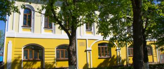
The old water intake complex is visible to all passengers of trains passing by the station. In the main room, the locking equipment marked “Imperial Iron Foundry” is still preserved. In the nineties, it was saved from scrap metal collectors. And at the beginning of the 2000s, the Kargatsky Museum of History and Local Lore was organized here. In the photo, to the left of the tower, a tall water heater pipe sticks out. In Soviet times, there was a horror story among local children that Kolchak’s soldiers burned captured Red Army soldiers in it...
Now in the building of the former water pump there is a museum of local history. Photo by the author
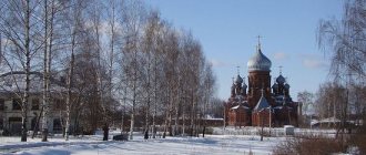
Temple
The temple can be seen in full view from passing trains. Much has already been written about him. It, unlike the two previous attractions, appeared quite recently. The monumental structure, huge by local standards, was built four years ago at the expense of a Moscow millionaire - he spent his childhood in Kargat.
The temple has everything: expensive high-quality paintings, a baptismal bath, separate buildings for an almshouse and the production of church accessories...
The whole complex, which, according to the religious authorities, could easily be given the status of a cathedral and used for holding major regional church events.
For now, the building is mostly empty. The population of Kargat does not exceed ten thousand people. Where do the crowds of parishioners come from? By the way, today a small and poor regional center is absurdly called a city. And in Russia, traditionally, if there was a church, a small settlement was called a village.
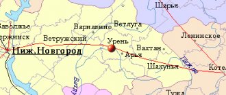
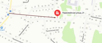
Map
| Kargath: maps |
Kargat: photo from space (Google Maps) Kargat: photo from space (Microsoft Virtual Earth)
| Kargat. Nearest cities. Distances in km. on the map (in brackets along roads) + direction. Using the hyperlink in the distance , you can get the route (information courtesy of the AutoTransInfo website) | |||
| 1 | Ubinskoe | 39 (48) | Z |
| 2 | Chulym | 44 (46) | IN |
| 3 | Satisfied | 87 (103) | SW |
| 4 | hummocks | 97 (99) | YU |
| 5 | Zdvinsk | 117 (226) | SW |
| 6 | Barabinsk | 123 (140) | Z |
| 7 | Kochenevo | 124 (130) | IN |
| 8 | Kuibyshev | 128 (150) | Z |
| 9 | Ordynskoe | 138 (197) | SE |
| 10 | Prokudskoye | 139 () | IN |
| 11 | Chick | 140 () | IN |
| 12 | Krutikha (Altai Territory) | 149 (270) | YU |
| 13 | Krivodanovka | 151 () | IN |
| 14 | Krasnozerskoe | 151 (191) | SW |
a brief description of
Located in the Barabinskaya lowland, on the river. Karagat (right tributary of the Chulym, Lake Chany basin), 177 km west of Novosibirsk.
Railway station.
Territory (sq. km): 282
Information about the city of Kargat on the Russian Wikipedia site
Historical sketch
Founded in the 18th century. on the river Kargath as Kargath outpost. In 1925 it was transformed into the village of Kargat. Hydronym, possibly from the ancient Turkic hag “boulder, pile of boulders.”
Since 1957, the working village of Kargat. Since November 30, 1965 the city.
Economy
Cheese and meat factories, forestry enterprises, etc.
In the Kargat region, rye, wheat, barley, and corn (for silage) are grown. Cattle and sheep are raised.
Deposits of clay, sand, peat, etc.
Culture, science, education
In the village of Mamontovo there are the remains of mammoths.
Museums, galleries, exhibition halls
Kargatsky Museum of History and Local Lore 632402, Novosibirsk region, Kargatsky district, Kargat, st. Lenina, 4 Phone(s): (38365) 21-507
| Population by year (thousands of inhabitants) | |||||||
| 1939 | 11.1 | 1998 | 12.7 | 2008 | 10.8 | 2016 | 9.6 |
| 1959 | 12.8 | 2000 | 12.3 | 2010 | 10.6 | 2017 | 9.5 |
| 1970 | 12.9 | 2001 | 12.1 | 2011 | 10.0 | 2018 | 9.4 |
| 1979 | 12.6 | 2003 | 11.2 | 2012 | 10.0 | 2019 | 9.2 |
| 1989 | 12.6 | 2005 | 11.0 | 2013 | 9.8 | 2020 | 9.0 |
| 1992 | 13.2 | 2006 | 10.9 | 2014 | 9.7 | 2021 | 8.9 |
| 1996 | 13.1 | 2007 | 10.9 | 2015 | 9.7 | ||
The city of Kargat in the Novosibirsk region
General information about the city of Kargat
Kargat is the regional center of the Kargat district in the Novosibirsk region. The city is located on a tributary of the Chulym - the Kargat River.
The distance to the regional center is 177 km. It is also a railway station on the Trans-Siberian Railway. The population of the city is mainly Russian, but there are also other nationalities - Germans, Kazakhs, Tatars, the number is more than 10 thousand people.
History of the city of Kargat
Kargat was founded in the mid-18th century (it is believed that in 1946) when the Kargat outpost was founded. And in the 90s of the 19th century, along with the construction of the railway, a village appeared. Since the station was close to the Kulunda steppes, the settlers settling in Kulunda traveled to Kargat by rail, and then moved further south on horseback. In winter, a sleigh route passed through Kargat, and it was a trading point where grain, meat, wool were bought, and then sent by rail to other regions of the Russian Empire and abroad.
In 1921, the Krgat district was formed with its center in the city of Kargat. Kargat changed its status several times, it was now a village, now a city, now a workers' settlement, and only in 1945 the village of Kargat received the status of a city and the administrative center of the Kargat region. Not far from the city there are two chapels and a temple.
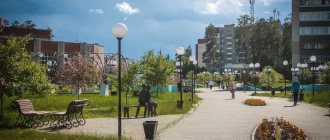
Sights of Kargat
The city has a local history museum, opened in February 1983. The museum has 10 exhibition halls, historical compositions are dedicated to the history of the development of the region and the city, the civil and Great Patriotic Wars, the life of Kargat residents and settlers, and the animal world of the region.
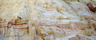
To the south of Kargat (62 km) there is “Wolf’s Mane” - a Paleolithic site of people of the Old Stone Age, which is more than 14.5 thousand years old. Since there was no stone suitable for economic use in this area, household items and even houses were built from bones, tusks and mammoth skins. 1.5 thousand mammoth skeletons were discovered at the site. And the village of Mamontova was formed on the spot where the last Siberian mammoths once lived.
Not far from Kargat (38 km) Lake Ubinskoye is located; in size in the Novosibirsk region it is second only to Chany. The shores of the lake are marshy, the bottom is clay covered with a layer of silt. The only species of fish found in the lake is silver crucian carp, although it is known that there used to be 10 species.
The Kargat River is the right tributary of the Chulym - 387 km long. It originates in the Vasyugan swamps from the lake of the same name. and flows into Chulym, not far from the village of Chulym.
Kargat, Kargat district
The Great Patriotic War broke out, and together with the whole country, little Kargat joined in the work for victory. The news of the beginning of the war reached the localities by special telegrams. A mobilization point was urgently organized at the district military registration and enlistment office. The notification took place through messengers.
The communists and Komsomol members were the first to respond. Of the 432 communists registered with the district party organization in 1941, 289 went to the Red Army. In the very first days, the front accepted every third Komsomol member of the region.
“The enemy wants to make us all slaves, turn us into draft animals, and destroy Soviet power, won in the battles of the October Socialist Revolution. “Everyone has one choice: victory or death,” with these words they escorted the soldiers of the Siberian Volunteer Division to the front.
In November 1941 In Kargat, the formation of the 72nd separate Red Banner Order of the Red Star naval brigade began.
The war years became a time of mass heroism not only at the front, but also in the rear.
From the first days of the war, residents of Kargat and the region actively participated in the creation of the country's defense fund. They contributed personal savings, government bonds, and food products to the Motherland Defense Fund. On November 7, 1941, all enterprises and institutions were working, and all daily earnings were transferred to the country's defense fund. Collective farms of the Kargat region collected funds for the construction of the combat air squadron “For the Motherland”. A collection of gifts and warm clothes was organized for the Red Army soldiers. From the minutes of the meeting of the board of the collective farm “Invincible” of the Marshansky village council dated October 13, 1942. “Send 2 pigs, 5 kg from the collective farm to the soldiers of the Red Army. butter, 10 kg. wool, 5 sheepskins...” The village gave everything it could. It lost a significant part of its tractor and car fleet, as well as horses. The men went to the front. The main burden of all work fell on the shoulders of women, old people and children.
During the Great Patriotic War, the farms of the Kargat region provided for the Red Army
Bread - 316.82 centners. Meat - 48,435 quintals. Oils - 11,420 quintals. Different leathers - 42,360 pieces. Wool - 1,370 quintals. Eggs -625,000 pieces.
Potatoes and other vegetables - 50,000 centners.
Kargat made its contribution to the victory by accepting evacuees from the western regions, mainly from besieged Leningrad, Stalingrad, Karelia and Belarus.
June 22, 1942 An order was issued by the Kargat Executive Committee “On the reception of Leningraders who arrived in the region.” The buildings of the district store, district store and railway club were designated as preliminary accommodation points for evacuees.
The first trains with evacuees began to arrive in October 1942. Then 2,000 people arrived in the area, 1,500 were temporarily housed in Kargat. In September 1942, there were 410 families evacuated in Kargat; in October, another 500 people arrived.
Two orphanages were created in Kargat: one for children of Kargat and the region left without parents, the second for evacuees. The district executive committee opened an account in the Kargat branch of the state bank to raise funds for orphanages.
The work of orphanages is known from the memoirs of Anna Mikhailovna Ivanova, who worked as a teacher in one of them. Here's what she said:
“Orphanage No. 2 in Kargat opened on April 11, 1943. It was located in two buildings (the first was the house of the merchant Mariupolsky, where the last DOSAAF driving school was located, the second was where the bakery is now located).
There were about 150 students. They slept on trestle beds and were taken to the dining room for food (where the department store building is now located). They were taken in two or three shifts; since there was not enough outer clothing, they wore them in turns. In winter they fed on potatoes and frozen cabbage; in summer they went to the forest and ate wild onions, garlic, carabiner bulbs, and larvae.
They raised children up to 14 years old. Then they were sent to vocational schools in Novosibirsk, Irkutsk, Magnitogorsk, Kuibyshev.
In 1942-43, the Leningrad orphanage was evacuated; it was located on the site where the building of the first secondary school is now. This orphanage did not last long. As soon as the blockade was lifted, the children were sent to Leningrad. The supply of this orphanage was better than that of Kargatsky due to benefits. When the Leningrad orphanage left, Kargatsky moved into this long wooden building and remained in it until its closure (in 1962).
It was very difficult for students of ordinary schools during the war years. At this time, Mikhail Pavlovich Lyubomudrov worked at the Kargat secondary school. Something about his work is also known from his memoirs.
The school was wooden, two-story. Mikhail Pavlovich together with the students went to Urman to collect firewood for the school. They sawed and stabbed them themselves. Students also worked on the Red Plowman collective farm, harvesting flax, hemp, and potatoes, collecting money for the defense fund, and sending parcels and letters to the front. We helped large families of front-line soldiers.
The news of the long-awaited victory was as extraordinary as the beginning of the war. The population was also urgently notified through messengers. A solemn meeting took place in Kargat, which grew into a folk festival. All the accordions were on the street. Meetings of front-line soldiers also turned into holidays. We walked almost the entire street. People cried with joy and grief. There was more of the latter in the tears of the widows and mothers who received the funeral. As you know, out of the nine thousand soldiers of the Kargat region, almost half of those who went to the front did not return home.
For their courage and heroism, eight Kargat residents were awarded the high title of Hero of the Soviet Union:
Kozhemyakin P.P., Babaev N.A., Osiny I.I., Dombrovsky I.A., Golubovsky G.A., Leonchikov N.P., Pisarev G.I., Konstantinov L.S.
Three Kargat soldiers received the title of full holder of the Order of Glory: N.I. Gubyashkin, D.F. Skvortsov, V.N. Ivanov.
Returning front-line soldiers did not stay at home; according to the distribution of the district executive committee, they were sent to work: some to the old pre-war work, some to the new one. There were still difficult post-war years ahead.
Domes and towers of Kargath: urban legends
In any small town or village there is a place or building that every local resident has known since childhood.
There are three such places in Kargat: a water pump, a dam and a temple. There are touching naive legends about them, which sometimes have a very real historical basis.
As a settlement, Kargat would never have appeared on the map - a continuous swamp, salt licks and an abundance of blood-sucking insects did not attract anyone. But at the end of the 19th century, the Barabinsk steppe was drawn by the smooth line of the Trans-Siberian Railway. At that time, the specifics of locomotive traction required refueling locomotives with fuel and water over a certain distance. Then it was about 40 kilometers. This is exactly the distance today between neighboring stations (at the same time, regional centers) Kargat, Chulym and Ubinskaya.
Dam
To ensure guaranteed water intake from the shallow Kargat river, the level had to be raised and the builders had to build a dam. They brought in a couple of trainloads of huge granite blocks and filled the riverbed with them near the “cast iron,” as the railroad was called then. Nearby, on a high bank, a water tower, a furnace for heating water and a pumping station were built.
Today, locals like to relax at the dam, for some reason traditionally pronouncing this word with the emphasis on the last syllable. Men from the surrounding houses fish here.
Water pump
The old water intake complex is visible to all passengers of trains passing by the station. In the main room, the locking equipment marked “Imperial Iron Foundry” has not been preserved. In the nineties it was stolen by scrap metal collectors. And at the beginning of the 2000s, the Kargatsky Museum of History and Local Lore was organized here. In the photo, to the left of the tower, a tall water heater pipe sticks out. In Soviet times, there was a horror story among local children that Kolchak’s soldiers burned captured Red Army soldiers in it...
Now in the building of the former water pump there is a museum of local history. Photo by the author
Temple
The temple can be seen in full view from passing trains. Much has already been written about him. It, unlike the two previous attractions, appeared quite recently. The monumental structure, huge by local standards, was built four years ago at the expense of a Moscow millionaire - he spent his childhood in Kargat.
The temple has everything: expensive high-quality paintings, a baptismal bath, separate buildings for an almshouse and the production of church accessories...
The whole complex, which, according to the religious authorities, could easily be given the status of a cathedral and used for holding major regional church events.
For now, the building is mostly empty. The population of Kargat does not exceed ten thousand people. Where do the crowds of parishioners come from? By the way, today a small and poor regional center is absurdly called a city. And in Russia, traditionally, if there was a church, a small settlement was called a village.
Photo by Elena Zabordaeva, Elena Demidova, Karga and from an open source