Verkhoyansk Airport In the north of Yakutia (aka the Republic of Sakha) beyond the Arctic Circle in the area of permafrost, the thickness of which in these places reaches 500 meters, there is a fairly large but deserted Verkhoyansk region. Just imagine: only about 12 thousand people live on a vast territory, and the population density is 1 person per 10 square kilometers! 70 percent of the inhabitants are Yakuts, 20 percent are Russians, 10 percent are other peoples.
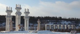
Batagay is the main city of this area. It appeared on the map of the USSR in 1939 and was one of the first workers' settlements in Yakutia. Before this, many minerals had been found in the surrounding area, so there was a need to build a large processing plant, around which a small village arose. The factory existed until 1973 and was closed, and the village became the administrative center of the Verkhoyansk region in 1954.
Although Batagai was founded, by historical standards, quite recently, no one remembers the exact history of the name. The most common version among historians is that the city was named after the Batagai clan of Yakuts, whose representatives once settled in these places and named everything in their honor. For example, not far from the city there is a river of the same name.
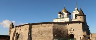
Although according to documents the main one is now Batagai, the historical and cultural center of this area is considered to be Verkhoyansk, located about 70 kilometers from it - one of the oldest northern cities in Russia and the same age as Yakutsk. It was founded as a winter hut for the Cossacks in 1638, and already in 1805 it became a city and received its own - Verkhoyansk - district.
But there are no questions about the name of this city: it is located in the upper reaches of the Yana River.
In the 19th century, it was a typical small Siberian district town with a large number of townspeople of Russian origin, with the usual officials and Cossacks familiar to central Russia. From the middle of that century, all kinds of Narodnaya Volya members and other citizens disliked by the Russian autocracy began to be actively exiled to it.
Why go to such distant lands?
Why go to Batagay
Most tourists who reach Batagay say that there is nothing to do there. However, if you are interested in the aesthetics of the real Russian outback, then it’s worth taking a walk around the city, and at the same time visiting the geological museum of JSC Yangeology. However, most travelers come to Batagai for its surroundings.
Pointer to Batagai
Batagaika
Near the city there is “Batagaika” - a huge “pit”, or as it is also called a “crater”, where you can very clearly see what permafrost is. In fact, this is neither a crater nor a pit, but a fault formed in the last century, when forests began to be actively cut down in those places for the construction of the city. The earth literally opened up along a small, barely noticeable stream, the sun warmed the walls and widened the rift. Now its width reaches 700 meters, length - about a kilometer, depth - from 45 to almost 100 meters. Every year the fault increases by several meters.
Fault near Batagai
At the edges of the giant fault, scientists examine layers from different times and claim that now, descending to its bottom, you can travel back almost 200 thousand years. In these same places, “mammoth hunters” find tusks and skeletons of animals that lived in these areas tens of thousands of years ago: not only mammoths, but also horses, bison, and wolves. By the way, this business is quite profitable: the price per kilogram of mammoth tusk on the “black” market reaches 25-30 thousand rubles, the weight of one tusk is 40-60 kilograms.
Being near Batagaika, you can hear the earth breaking: strange loud sounds are constantly heard in the “crater”, something between a crash and gunshots.
You can get to the fault by taxi. It is about 7 kilometers from the city, that is, it is better to take a car for a couple of hours (it costs about 500 rubles per hour) in order to get there calmly, walk about a kilometer to the fault, look at it, listen and return. If you plan to descend into the “crater” and walk along the bottom, allow much more time. Please note that there are no stairs there, the soil is slippery, so you need to do this very carefully.
Fault-crater Batagaika
Mount Kester
Approximately 65 kilometers from Batagay, near Mount Kester, the buildings of YanLager are preserved - one of the camps of the Gulag system, in which several thousand prisoners mined tin in the 40s of the last century. In total, during the Stalin era, there were 105 camps on the territory of Yakutia, but now most of them are practically inaccessible, while this can be reached by hiring a car (this will cost about 12-15 thousand rubles, because the road is very bad).
Many buildings have been destroyed, but some can still be seen, as can the road on the rock along which prisoners transported wheelbarrows of ore. There is a memorial slab in the middle of the cobblestones.
Betenkes
About 50 kilometers from Batagay is the village of Betenkes, where a very good paleontological museum was opened several years ago, which everyone who comes to this area is advised to visit. The museum houses rare finds - bones of ancient animals found nearby. A taxi to Betenkes will cost 3000-4000 rubles.
Theaters and concert halls
In Yakutsk there are several places for organizing cultural leisure. For example, lovers of classical music can visit the local Opera and Ballet Theater, founded in 1971, and at the Pushkin Russian Drama Theater they will be invited to become spectators of performances based on the works of Russian and foreign playwrights.
This cultural institution is also known for the fact that all the most significant events in the public life of the republic, including the inauguration of the president, take place within its walls.
How to get to Batagay
All year round you can fly to Batagai by plane from Yakutsk by air. Round-trip tickets cost about 20-35 thousand rubles. Travel time is 1.5-2 hours.
You can also get to Batagai by car at the end of winter and spring, but you don’t need to: the “winter road” starts operating - a route that exists only in winter. The distance from Yakutsk to the main city of the region is 1068 kilometers. The road is not particularly good, and therefore the entire journey will take more than three days.
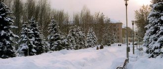
By the way, winter in these places lasts 7 months, and spring comes at the end of May, when green shoots appear, and by the end of September the ground is covered with snow again.
Olekminsk
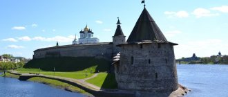
Olekminsk , a regional center in Yakutia, 651 km southwest of Yakutsk. Located in the south of the Lena Plateau. Pier on the left bank of the river. Lena. Airport. Population 10.6 thousand people (1992). Founded by a detachment of Yenisei Cossacks under the command of P. Beketov in 1636 as a small fort opposite the mouth of the river. Olekma, then moved 12 km upstream of the Lena, to a more convenient, flood-free place. Located at the junction of two waterways (Lena and Olekma), the Olekminsky fort was a rallying point for Cossack detachments moving to the river. Amur. Later it acquired the importance of a trade and administrative point on the way to Yakutsk. In 1783 it became a district town of the Yakut region, in 1822 - a district town. The Decembrists N. A. Chizhov, A. N. Andreev, and others served their exile in O. In 1897, there were 120 wooden houses, 26 yurts, 2 churches, a hospital (with 8 beds), a parochial school, and 2 colleges in O. , about 1 thousand people lived here. The annual Olekma fair lasted several days; merchants traded in textiles and other goods, local residents traded in furs, fish, meat, leather, etc. In modern O.: timber industry enterprises; meat processing plant, bakery; power station. Geological party "Oil Exploration" and others. Center of the agricultural region (grain crops - wheat, rye, oats, barley; vegetable growing; livestock - cattle, horses, deer). Museum of Local Lore. The city has preserved wooden houses from the 19th century. with carved cornices and applied carvings on windows, gates, and wickets.
LENSK , regional center in Yakutia, 840 km west of Yakutsk (by air). Located on the Prilensky plateau, on the left bank of the river. Lena. A large river port for receiving and transporting goods for the diamond mining industry of Yakutia. Connected by road with the city of Mirny. Airport. Population 30.9 thousand people (1992; 23.9 thousand in 1979). Founded as a settlement of “industrial” people on the site of the Evenki camp Mukhtuy (Mukhtukuevskaya village; in Evenki - big water) no later than 1663. In the 1730s. To serve the 2nd Kamchatka expedition of V. Bering, the Yamskaya (postal) station Mukhtuya was opened here. In the XIX - early XX centuries. - a place of political exile. The city grew in connection with the discovery and development of diamond deposits in the Vilyuya basin. The village of Mukhtuya, as the closest Lena village to the Mir kimberlite pipe, became the base for the construction of the city of Mirny. In 1956, construction of a road began from Mukhtui to the future Mirny, and the first port berths appeared on the outskirts of the village. In 1963, the working-class village of Mukhtuya was transformed into a city of regional subordination of Leningrad. In modern Leningrad: NPO Yakutalmaz; forestry and woodworking industry enterprises; building materials plant; large-panel house-building plant. Food enterprises. Branch of the Bashkir Geophysical Institute. Expeditions: geophysical, oil and gas exploration NPO "Lenaneftegazogeologiya". Museum of History and Local Lore. The main streets of the city are lined with multi-storey buildings. On the embankment there is a square with an obelisk monument in memory of the residents of Mukhtui who died during the Great Patriotic War of 1941-45. In the western part of Leningrad there are fields and hayfields; meat and dairy farming, crop farming. In the vicinity of the city there are oil and gas fields.
Why go to Verkhoyansk
Verkhoyansk is one of the coldest cities in the Northern Hemisphere. Local authorities decided that this could become a tourist “trick” and installed a memorial sign stating that Verkhoyansk is a “pole of cold” and give “diplomas” to visitors to this place.
Verkhoyansk - Pole of Cold
Indeed, this is the coldest place in Yakutia, where, due to the sharply continental climate, there is a huge temperature range and very little precipitation. In winter, the usual air temperature is -38--48 degrees.
Do you, like me, remember from school that the “pole of cold” and the frostiest place on Earth is Oymyakon? This village, indeed, tried to retain its former glory and compete with the city, but the authorities of Yakutia not so long ago gave the palm to Verkhoyansk. They motivated this by the fact that it was in Verkhoyansk in February 1892 that the lowest temperature outside Antarctica was recorded - -67.8 degrees. Whereas in Oymyakon in February 1933 they measured -67.7 degrees. However, some scientists agree. They do not agree that Verkhoyansk won, because the average annual temperature is 0.3 degrees lower in Oymyakon.
You will be told in more detail about why Verkhoyansk is the coldest place on the planet in the local history museum, which is called “Pole of Cold” (entrance ticket - 200 rubles).
If you have a lot of time, you can get to know this region more thoroughly. For example, visit natural monuments: a sacred place of the northern peoples and one of the highest mountain peaks of the Verkhoyansk region “ Mother Mountain ” (Mount Ulakhan-Ynnakh ) and “ Kisilyakh Kihileekh Mountains ) with bizarre remains that from a distance look like a group of people, a resource reserve “ Tuostakh ” (Tuostakh locality), where you can meet rare animals and see a variety of plants.
Capital of Yakutia: temples
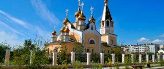
The city has several churches and religious buildings built over the years. In particular, you can visit the St. Nicholas Church, which is the only building of its kind that has preserved its original architectural appearance from the 19th century. The church is notorious for the fact that in the first years of Soviet power, in its fence, the “Reds” shot those who at that time were considered “counter” - representatives of the intelligentsia and clergy, as well as businessmen, among whom there were many philanthropists. Another ancient temple of Yakutsk - the Gradoyakut Transfiguration Cathedral - was built in the 20s of the last century at the expense of the Solovyov merchants. It is the main church of the Yakut-Lena Diocese.
Since 1997, the city has also operated the Chapel of Innocent, Metropolitan of Moscow, which is located in the courtyard of the Museum of History and Culture of the Peoples of the North.
Since 2005, there has also been a mosque for Muslim believers in the city.
Tips for tourists traveling to Bagatay and Verkhneyansk
- The time difference between Batagai and Yakutsk is 1 hour, in Batagai it is 1 hour more. Don't forget about this and don't miss your return flight!
- Try to bring as much food as possible from Yakutsk, because prices in local stores are steep: they are 2-3 times higher than in the capital of the republic.
- If you are traveling in the summer, take as much repellent as possible. Your clothes should provide good protection not only from mosquitoes, but also from gadflies, ticks and midges.
- Don’t count on mobile Internet, or indeed on good telephone connections: the coverage in these places is not very good, the signal regularly disappears, and it is very difficult to find a place where there is wi-fi.
- Take very good, comfortable, closed, non-slip shoes: simply put, trekking boots are the only suitable footwear for these places.
- Calculate your travel time with reserve, any of the flights can always be canceled - this is not uncommon in the Arctic regions of Russia - and you can stay in Batagay for several days!
Yakutsk
(The Republic of Sakha (Yakutia))
OKATO code:
98401
Founded:
1642
City since:
1642 City of republican subordination
Center:
Republic of Sakha (Yakutia)
Telephone code (reference phone)
| 4112****** | — |
Deviation from Moscow time, hours:
6
Geographic latitude:
62°02′
Geographic longitude:
129°44′
Altitude above sea level, meters:
120 Sunrise and sunset times of the Sun and Moon in the city of Yakutsk