What is the difference between Rostov the Great and Rostov-on-Don? The answer to this question is unequivocal, the Altai Territory and the Altai Republic are two different subjects of the Russian Federation, although they are located next to each other. And, despite the fact that they had a “common” fate for quite a long period of time, historically these two regions have never been a single whole. Let's try to figure out why.
The territory of the modern Altai Territory until the beginning of the 20th century belonged to the Tomsk province (together with the territories of the modern Tomsk, Novosibirsk and Kemerovo regions, as well as part of the Krasnoyarsk Territory). It, like the entire territory of the Upper Ob region, became part of the Russian Empire by 1721 (according to official documents, not officially much earlier). The territory of the Altai Republic was annexed to Russia only in 1756 and it was not part of the Tomsk province.
In 1916, by decision of the Provisional Government, a separate Altai province was separated from the Tomsk province, with Barnaul, Biysk, Slavgorod, Kamensk and Zmeinogorsk districts. Under this name it existed until 1925, then from 1925 to 1930 it was part of the Siberian Territory, from 1930 to 1937 it was part of the West Siberian Territory (one can easily get confused in the administrative changes in the territory of Siberia in the first half of the 20th century). In 1937, the Altai Territory was finally formed with the administrative center in Barnaul.
What about the “second”? The establishment of Soviet power in the mountainous regions dragged on until 1919; since 1922, this territory was annexed to the Altai province (later to the Altai Territory) as an autonomous region. The names of the region also changed, at first it was Oirotskaya, with its center in the village of Ulala, which was the name of modern Gorno-Altaisk, then Gorno-Altaiskaya. The status of a separate entity within the Russian Federation was obtained in 1992, although a year later the name was changed again, from the Altai Mountain Republic to the Altai Republic. Unofficially, the name “Mountain Altai” was assigned to the region.
Despite their almost 70-year joint history, the regions are so different that it is impossible to compare them, much less confuse them. And if residents of the Novosibirsk or Tomsk regions say “We went to Altai,” then from the residents of the Altai Territory you can easily hear the phrase “We went to Gorny.” “Altai” is common between the two regions, but it is “mountainous” only in the Republic.
Thanks to the common “Altai” in their names, the regions are often confused, mainly, of course, by those who have never been here. The easiest way to understand where you are is by the names of settlements; in the Altai Republic they are most often Altai (Uznezya, Kosh-Agach, Ust-Koksa), and in the Altai Territory they are Russian (Obraztsovka, Altaiskoe, Belokurikha). Although there are exceptions, for example, there is the village of Katun in the Altai region of the Altai Territory, and there is the village of Tourbaza “Katun” in the Chemal region of the Altai Republic, tourist sites are located in both villages and they are often confused.
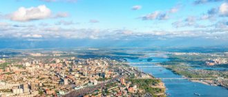
Nowadays, the Altai Territory is : - a subject of the Russian Federation on the territory of Western Siberia, included in the Siberian Federal District; - the capital of the Altai Territory is the city of Barnaul, located on the Ob River; — internal borders with the Altai Republic, Kemerovo and Novosibirsk regions, external border with the Republic of Kazakhstan — area 168,000 sq. km; — population is about 2,300,000 people, by national composition more than 93% of the population are Russians; — the largest cities are Barnaul (630,000 people), Biysk (200,000 people), Rubtsovsk (140,000 people), Novoaltaisk (a suburb of Barnaul, 75,000 people), Zarinsk (45,000 people), Kamen-on-Obi (40,000 Human); — population density is about 13 people/sq. km, the ratio of urban and rural population is approximately 50/50 with a slight predominance of urban; — the main share of the economy (56%) falls on three areas: industry, agriculture and trade.
By 2022, the Altai Republic is: - a subject of the Russian Federation on the territory of Western Siberia, included in the Siberian Federal District; — the capital of the Altai Republic and the only city on its territory is the city of Gorno-Altaisk, the Maima River (the right tributary of the Katun) flows through the city; — internal borders with the Altai Territory, Kemerovo Region, the Republics of Khakassia and Tyva, external borders with the Republic of Kazakhstan, Mongolia and China; — area 93,000 sq. km; — population is 221,000 people, the main national groups are Russians (56%) and Altaians (34%); — the largest settlements are Gorno-Altaisk (64,500 people), Maima (a suburb of Gorno-Altaisk, 17,000 people), Kosh-Agach (11,000 people), Turochak, Ust-Kan and Chemal (5,000 people live in each of them) ); — population density 2.4 people/sq. km, more than 70% are rural residents; — the basis of the economy is agriculture (more than 50%) and tourism.
How does the Altai Republic differ from the Altai Territory
Located in Western Siberia (the Altai Republic is slightly east of the Altai Territory), these two regions have a fundamentally different landscape of the territory. In the Altai Territory, flat areas predominate, and in the Altai Republic, mountainous and high-mountain steppe zones predominate. Agriculture plays an important role in the economy of both regions, but if in the Altai Territory it is primarily agriculture, then in the Altai Republic it is animal husbandry. But both “neighbors” are engaged in breeding bees and producing honey.
The second “common” component of the life of the regions will be tourism, but if in the Altai Republic this is, first of all, excursion (archaeological) and active recreation (rafting, hiking, horseback riding and hiking trails), then in the Altai Territory it is a comfortable vacation at tourist centers and medicinal in Belokurikha.
Altai is different, but it is amazing and beautiful, no matter which corner of it you see!
Promote the exhibit
The monograph and expeditions are not the only projects of the Great Altai. The forum presented the “Virtual Museum of Altai Archeology and Ethnography” - a platform accessible to scientists and all history buffs.
Yaroslav Frolov, director of the Museum of Archeology and Ethnography of Altai Altai State University:
“This is a platform for integrating information resources of different museums on a single platform. It will incorporate a wide range of collections that currently exist in various regions.”
The main feature and main section of the virtual museum are 3D models of artifacts. You can click, for example, on a figurine of a warrior from the 7th century, and rotate it from all sides, which, of course, is impossible in an ordinary museum.
Virtual museum.
bolshoy-altay.asu.ru.
In other sections (which should be created soon) there will be data on archaeological monuments and important stages in ancient Turkic history, as well as selections of exhibits - by period, territory and other parameters.
Cities and large villages of Altai
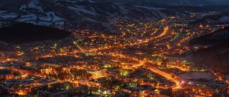
Gorno-Altaisk (60,828 people) is the only city and capital of the republic. Founded in 1824 by Russian settlers. Among the enterprises here, only a reinforced concrete products plant can be distinguished. All other industry created under Soviet rule has collapsed. But the governing bodies of the Altai Republic are located here: the government, the Kurultai, various ministries and committees. There is an airport to receive tourists. Pros: ecology, presence of nearby mountain resorts. Cons: lack of work, low salaries.
Maima (population: 16,399 people) is a village on the right bank of the Katun River, in fact, a suburb of Gorno-Altaisk, which is located 9 km from Maima. Founded in 1811. The infrastructure in the village is poorly developed, so residents of Maima go to neighboring Gorno-Altaisk in search of entertainment.
Kosh-Agach (population - 8325 people) is a village founded in 1801, which developed as a merchant center. Located in the southeast of the republic, on the famous Chuisky tract, 65 km from the Mongolian border. Behind it the border zone already begins, so a pass is required to travel through it. Kosh-Agach is the sunniest place in Russia.
Valley of the Chulyshman River
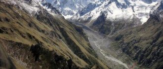
And at that moment when the traveler may naively think that he has already seen the whole of Altai, the Chulyshman Valley opens up to him - one of the most spectacular places in the lowlands of the Altai Mountains, a wild land of rare beauty, a unique gorge 241 km long.
Chulyshmanskaya (Chelushmanskaya) valley. Photo: Zara Ajemyan
It would be worth going to Altai just for Chulyshman. The main “hits” here are considered to be the Stone Mushrooms in the Akkurum tract, one of the natural wonders of the Altai Mountains, and the Uchar Waterfall.
Akkurum stone mushrooms. Photo: press service
Uchar (or Big Chulchinsky waterfall) on the territory of the Altai Nature Reserve is the largest cascading waterfall in the Altai Mountains: it is a steep, but not vertical, ledge with a total height of 160 m. Uchar is one of the five most inaccessible attractions in Russia. However, this fact only spurs the interest of travelers.
Uchar (Big Chulchinsky waterfall). Photo: Wikipedia
Etymology
Name Altai
ancient, hypotheses about its origin are different.
- According to the German philologist and geographer A. Humboldt: “Altai, in Chinese and Mongolian: Golden Mountain (Altaun oola) or Kin-shan”
[4].
According to G. Ramstedt, the name Altai
comes from the Mongolian word
alt
- “gold” and the pronominal formant
-tai
, that is, from the word
Altai
- “gold-bearing”, “place where there is gold”. This version is confirmed by the fact that the Chinese used to call Altai “Jinshan” - “golden mountains”, obviously, this is a translation from Mongolian. [5]
- According to one of them, the name is formed by the Mongolian colloquial word “Altai”, which means “a mountainous country with alpine meadows; nomads in the high mountains." But it is also likely that this term is secondary, that is, on the contrary, it comes from the name of the mountains.
- There is also an explanation of the origin from the Turkic alatau
- “variegated mountains”, which is associated with the color of the Altai highlands, where nearby there are areas with white snow, black rocky placers and green vegetation. - Radlov put forward a hypothesis about the origin of the Turkic words al
- “high”,
tai
- “mountain”, which is rejected by modern data[6].
Kyzyl-Chin or “Altai Mars”
The easternmost point of the route is the “Altai Mars”, beloved by all travelers. The range of these Rainbow Mountains lies in the Kyzyl-Chin gorge in the Chui steppe. Their unusual color - from bright red and orange to yellow and pale ocher - is due to the high content of iron oxide in the soil. Whether Mars itself is so beautiful is anyone’s guess, but “Altai Mars” is definitely worth seeing.
Near Aktash there is also a Geyser Lake, which does not freeze even in winter: a bright turquoise spot with a diameter of 30 meters in the center of a dense taiga massif looks no less alien than the landscapes of the Rainbow Mountains.
Notes
- Belukha (Highest point of Siberia) - Altai Tourist. Tourist portal
- Modern Altai-Russian dictionary (Russian). Kalaida
. Date accessed: February 6, 2022. - ↑ 1234
Bulanov, 2005. - Humboldt, 1837, p. 24.
- Molchanova, 1979, p. 130.
- Vasmer M.
Etymological dictionary of the Russian language (Russian). - Progress. - M., 1964–1973. - T. 1. - P. 72. - BUSLOV MIKHAIL MIKHAILOVICH.
Terrane tectonics of the Central Asian fold belt // Geodynamics and tectonophysics. — 2014-01-01. - T. 5, issue. 3. - Sokolova E. N., Smirnov S. Z., Astrelina E. I., Annikova I. Yu., Vladimirov A. G., Kotler P. D.
COMPOSITION, FLUID REGIME AND GENESIS OF ONGONITE-ELVAN MAGMAS OF THE KALGUTY ORE-MAGMA SYSTEM (Altai Mountains) (Russian) // Geology and Geophysics: journal. - 2011. - November 1 (vol. 52, no. 11). - S. 1748-1775. - “Hot time”: another earthquake was recorded in Altai (Russian). altapress.ru Access date: March 14, 2016.
- ↑ 1 2 3
About the modern landscape of the Altai Mountains (Russian).
News of Siberian science
(August 31, 2016). Date accessed: February 20, 2022. - Scientists have found traces of powerful ancient earthquakes near the future gas pipeline in Altai (Russian). TASS
. Date accessed: April 7, 2022. - ↑ 1 2
Ridges - Tourist Altai.
Tourist portal (Russian). www.vtourisme.com
. Access date: September 19, 2022. - ALTAI • Great Russian Encyclopedia - electronic version (unspecified)
.
bigenc.ru
. Access date: September 19, 2022. - Borisov A. A.
Climates of the USSR (Russian). - Moscow: Uchpedgiz, 1948. - 224 p. - truth”, Marina KOCHNEVA |
Komsomolskaya website .
Did lions and tigers live in Altai? (Russian), KP.RU - website of Komsomolskaya Pravda
(January 23, 2017). Retrieved January 25, 2022.
Ridges
- Kalbinsky
- Ubinsky
- Ivanovsky
- Ulbinsky
- Narymsky
- Kurchumsky
- Azutau, kk:Azutau
- Sarymsakty
- Tigiretsky
- Koksusky
- Kholzun
- Listvyaga
- Korgonsky
- Katunsky
- Baschelaksky
- Anuisky
- Cherginsky
- Seminsky
- Iolgo
- Sumultinsky
- Altyntu
- Tongosh
- Aigulaksky
- Terektinsky
- Severo-Chuisky
- Yuzhno-Chuysky
- Kuraisky
- Sailyugem
- Southern Altai
- Chikhacheva
- Kolyvansky
- Shapshalsky
- Kuminsky
- Azh-Bogd
- Biyskaya Griva
- Gurvan-Saikhan-Uul
- Ikh-Bogdyn-Nuru
- Beltirdu
- Tavan-Bogdo-Ula
- Corbu mountain range
- Delaunay ridge
- Mazhigan Ridge
- Chui squirrels[12][13][12]