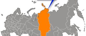
The Republic of Karelia is located in the north-west of the Russian Federation, part of the North-Western Federal District. It is also part of the Northern Economic Region. The capital of Karelia is the city of Petrozavodsk. The population is 629 thousand people, the density is 3.5 people per square kilometer. About half of the population lives in the city of Petrozavodsk. In terms of population, the Republic of Karelia ranks 69th among Russian regions.
The area of the region is 180.52 thousand square kilometers. The Republic of Karelia is a hilly plain with a large number of lakes and rivers. The highest point is Mount Nuorunen (577 meters). It borders with Finland, Leningrad, Vologda, Murmansk and Arkhangelsk regions.
It was formed in 1920 (Karelian Labor Commune), in 1923 it received the status of a republic.
Karelia, Suoyarvi district
Administrative structure
The Republic of Karelia consists of 18 administrative-territorial units, which include two urban districts and 16 municipal districts. The districts, in turn, include 87 rural and 22 urban settlements.
Janisjoki River
The total number of settlements (including those in which no one lives) is 818. There are 13 cities, 11 urban-type settlements. The rest are villages, villages and towns, many of which have a very rich history.
Table: regions of Karelia
| Area | Population | Area (sq.km) | Administrative center |
| Kalevalsky | 7064 | 13030 | Kalevala |
| Kondopoga | 37968 | 5940 | Kondopoga |
| Segezhsky | 37905 | 10640 | Segezha |
| Sortavala | 31245 | 2190 | Sortavala |
| Medvezhyegorsky | 28601 | 13730 | Medvezhyegorsk |
| Prionezhsky | 21830 | 4600 | Petrozavodsk |
| Olonetsky | 21070 | 3920 | Olonets |
| Pudozhsky | 18908 | 12660 | Pudozh |
| Pitkyaranta | 18250 | 2270 | Pitkäranta |
| Belomorsky | 17034 | 12930 | Belomorsk |
| Suoyarvsky | 16596 | 13580 | Suoyarvi |
| Kemsky | 15755 | 7950 | Kem |
| Pryazhinsky | 14455 | 6430 | Yarn |
| Lakhdenpokhsky | 13460 | 2180 | Lahdenpokhya |
| Loukhsky | 12055 | 22710 | Louhi |
| Muezersky | 10536 | 18180 | Muezersky |
Also two urban districts:
- Petrozavodsk - population 277 thousand people, area 112 sq. km;
- Kostomuksha - population 30 thousand people, area 4046 sq. km.
Detailed geography of the region
Karelia has a relatively small territory, and you can cross it all in just 1 day. During this time you can visit all major cities and historical regions.
Administrative regions
The administrative-territorial division of Karelia is such that the republic consists of 16 municipalities and two districts. All of them differ significantly from each other in nature, infrastructure and landscapes. To have at least a small idea of this region, it is enough to visit 3-4 of them.
Of course, the lake region cannot but be famous for fishing, so Karelia is often visited by lovers of this type of recreation. And in this article you will find out where else you can go for excellent fishing.
The most popular regions among tourists:
- Belomorsky – Osudareva road, White Sea petroglyphs, White Sea-Baltic Canal;
- Kalevalsky - Yamanen Barn, Kumi Waterfall, Kalevala Museum of Rune Singers;
- Sortavala – Ruskeala mountain park, Valaam island, Akhvenkoski waterfall;
- Pudozhsky – Onega petroglyphs, Murom Holy Dormition Monastery;
- Olonetsky - Vazheozersky Spaso-Preobrazhensky Monastery, as well as Syandemsky Assumption Convent;
- Kondopozhsky - Martial waters, Girvassky volcano, Kivach waterfall.
Also known are such administrative districts as Kemsky, Kostomuksha, Loukhsky, Muezersky, Prionezhsky, Pitkyaranta, Medvezhyegorsky and Segezhsky. Such places are notable for the abundance of nature reserves, mountains, lakes and settlements with a rich history.
Popular cities of the Republic - photos
The cities of Karelia look very attractive - ancient settlements with amazing and unique beauty that leaves a mark on the soul and makes you return to these lands to see them again. The main city of the republic is Petrozavodsk.
There are a total of 13 large cities in this region, but with a fairly small population.
At the very border of Karelia and the Leningrad region - next to the place from which it is easiest to get to this region, Priozersk . The city is located on the coast of Lake Ladoga, and walks along it will allow you to see the legendary Korela fortress - a defensive structure that was owned at different times by Russians, Finns, Swedes, Lithuanians and Novgorodians.
Here you can also get acquainted with other interesting places :
- Lutheran Church Käkisalmi;
- All Saints Church;
- Mowgli monument.
Priozersk itself is a fairly miniature town, therefore, in addition to exploring its attractions, tourists go outdoors to go rafting or ride catamarans on the Vuoksa .
If you are looking for a place for permanent residence, prefer a quiet pace of life and love picturesque natural landscapes, then Karelia is ideal for you. Read here where else you can move to live in Russia.
The list of large cities continues with Kostomuksha , a settlement formed in 1983 on the site of a village with the same name. In this part of the republic there are several plants, including the Karelsky Okatysh mining and processing plant. Next comes Segezha , a settlement on the shores of Lake Vygozero.
Small towns are also attractive :
- Sortavala is the second most popular settlement, where routes to the island of Valaam start;
- Medvezhyegorsk is a city 152 km from Petrozavodsk, built as a settlement for railway builders;
- Kem is an ancient town on the river of the same name, founded in 1785.
Very small, but quite popular, cities include: Belomorsk, Suoyarvi, Pudozh, Olonets, Lahdenpokhya and Pitkäranta.
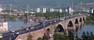
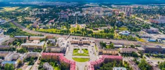
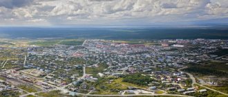
The heart of Karelia is the city of Petrozavodsk - the largest settlement of the republic with a unique nature, as well as ancient buildings and modern houses. It is located on the coast of Lake Onega, a body of water that has access to the Caspian, Baltic, White and Black Seas. That is why the city itself is called the “port of the five seas.”
Petrozavodsk is located 400 kilometers from St. Petersburg and 350 kilometers from the border with Finland. It has road, rail and air connections to many other major cities.
Nowadays, the city is actively developing as a center for tourists, where you can see the sights or relax in nature.
Economy
Four districts of the Republic of Karelia (Kalevalsky, Kemsky, Belomorsky and Loukhsky), as well as Kostomuksha, have the status of regions of the Far North. Another 11 districts have the status of localities that are equal to the regions of the Far North. This provides certain benefits to people who work and live in these areas.
The economy is dominated by the mining and timber industries. The timber industry complex accounts for about 28% of the republic's production; by the way, the republic accounts for 24% of paper production in Russia. Logging is actively underway, the forest area is estimated at 14.5 million hectares, and the total timber reserves are approaching 1 billion cubic meters.
Loukhi district
Mineral resources in Karelia include shungite, raw materials, building stone, and sand. There are many hydroelectric power stations on the territory of the republic, which is explained by the large number of rivers. In total, there are 18 hydroelectric power stations in Karelia, which account for more than 70% of the electricity generated in the region.
Agriculture cannot be called developed, but this is due to unfavorable climatic conditions. Cultivated lands account for about 1.2% of the area and are mainly located in the southern and central parts of the Republic of Karelia. The following sectors predominate in agriculture:
- Livestock;
- Pig farming;
- Poultry farming;
- Trout farming;
- Plant growing;
- Fishing.
It is worth noting trout farming - enterprises in the field of aquaculture are actively developing and opening in Karelia. Today this direction is considered quite promising, and the region has all the suitable conditions for this.
How to get to the magical land?
Karelia is conveniently connected to many cities, so getting to the republic is not difficult.
We fly by plane
The fastest way to get to Karelia is to take a plane from Moscow to Petrozavodsk. Flights to this part of the republic operate from April to November on Tuesdays, Thursdays and Saturdays. Flights depart at 7:55 and arrive at 9:55.
You can purchase a plane ticket right now using this search form. Enter the cities of departure and arrival , date and number of passengers .
We're going by car
The most convenient way to get to know Karelia is to travel to this region by car. Along the way you will be able to visit different places, getting acquainted with nature, life and culture.
A road passes through its entire territory - “Kola” - a highway leading from St. Petersburg to Murmansk. The total length is about 1000 kilometers. You can get there from St. Petersburg (travel time 4 hours) or from Moscow (about 13 hours).
Most often, this method is chosen by those who want to visit not only cities, but also visit the islands of Karelia, for example, Valaam. To do this, from St. Petersburg you need to get to Sortavala, Priozersk or Petrozavodsk, and from there by “meteor” by water to Valaam.
Another exciting and economical option for traveling to Karelia is hitchhiking. Read this article for tips for novice travel companions.
Let's go by train
from major cities in Russia, heading to or passing by the railway station in Petrozavodsk. On train No. 018 you can get from Moscow in 14 hours, from St. Petersburg by train No. 658 in 4 hours (from Ladozhsky station), and from Murmansk by train No. 092A. Also passing through Petrozavodsk are the Minsk-Murmansk trains, a train traveling through Kyiv, Brest, Gomel and Grodno.
Tourism in Karelia
Tourism is an important part of the economy of Karelia, accounting for more than 5% of the republic's GDP. First of all, the region attracts tourists with its nature and natural attractions, as well as historical and architectural monuments. Low population density and competitive prices help attract a flow of people. A huge number of rivers and lakes attract lovers of water tourism, fishermen and hunters.
Some events (for example, stages of the Russian Rally Championship) attract tens of thousands of people here every year. Many areas host other events that annually attract tourists' interest.
However, it is worth noting that the tourist service in Karelia still leaves much to be desired. The leadership of the republic is taking certain steps in this direction, the flow of tourists is growing every year, but in this regard, Karelia still has room to grow. However, for lovers of wild outdoor recreation, hiking, etc., Karelia is one of the most attractive regions in the Northwestern Federal District.
Rally
Nature, sights
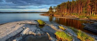
There are about 61 thousand lakes, 27 thousand rivers and 29 reservoirs in the region.
Where is the Karelia freshwater lake located? The largest such lake in Europe is Ladoga, located in the south of the republic. The second largest is Lake Onega. The largest rivers are Unga, Kovda, Sunna, Shuya, Vyg, Vodla, Chirga-Kem, Kem and Onda.
Magnificent sights and pride of Karelia are the Solovetsky Monastery, Kizhi and Valaam. All of them are included in the UNESCO list. Here you can see ancient petroglyphs (rock images), you can take a trip around Lake Onega on a yacht, admiring the delightful landscapes of natural parks and reserves.
One of the most unique mystical places in Karelia is Mount Vottovaara.
Where Karelia is located, the terrain is predominantly flat. Nuorrunen (the highest mountain) rises only 576 meters.
Roads of Karelia
There are about 8 thousand kilometers of roads in Karelia, but only the main highways are paved. This is due to the low population density. For example, the area of the Suoyarvi district is 13.7 thousand sq. km, the population is 16.5 thousand people. All roads outside villages and cities are unpaved. Obviously, with a density of 1.2 people per square kilometer, it doesn’t make much sense to asphalt tens and hundreds of kilometers of roads.
If we talk about asphalt roads, most of them are in good condition. This also applies to the P-21 “Kola” and A-121 “Sortavala” highways. In some places (as in the Lakhdenpokh region) new roads are being built, and in some places repairs are underway.
It is quite difficult to characterize the condition of dirt roads; it depends not only on the area, but also on the time of year and climatic conditions. For example, in 2014, the road from A-121 to the city of Suoyarvi did not allow driving faster than 40-50 km/h, but the road from Suoyarvi to Porosozero allowed driving up to 100 km/h. In general, frankly bad and difficult sections of roads in the Republic of Karelia are quite rare.
We are talking about roads that are used every day; if you drive into the wilderness, then anything can await you there, so you should not trust reviews in the style of “there is an excellent road to Lake X.” It could have been great in 2012, but in 2016 it is no longer possible to drive on it.
In general, if you do not plan to visit remote areas far from populated areas, then you will not need a cross-country vehicle. The main attractions of the Republic of Karelia can be reached by a regular car.
Capital, cities
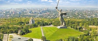
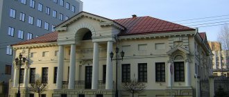
The largest city in Karelia is the capital of the republic Petrozavodsk (269 thousand people). It is located on the shore of the famous Lake Onega. The city received its name in honor of the arms factory, which was founded by Peter I in 1703. Since then, the small town quickly turned into a huge fortress.
Today Petrozavodsk is the most important commercial, industrial and scientific center in the north of Russia. The city and its surroundings have excellent infrastructure, ecology and nature. The climate is rainy and cold.
Large tourist centers and cities of Karelia: Kondopoga, Sortavala, Kem, Kostomuksha, Medvezhyegorsk, Pudozh, Belomorsk and Olonets.
Symbols of the Republic
State flag of the Republic of Karelia State emblem of the Republic of Karelia
Flag of the Republic of Karelia
The state flag of the Republic of Karelia is a rectangular panel with equal horizontal stripes: the top stripe is red, the middle stripe is blue and the bottom stripe is green. The ratio of the width of the flag to its length is 2:3. (Constitution of the Republic of Karelia, Article 12).
Coat of arms of the Republic of Karelia
The state emblem of the Republic of Karelia is a rectangular shield, rounded in the lower third, crossed three times in equal parts with the colors of the state flag of the Republic of Karelia, with the profile of a standing black bear depicted on it. The golden frame of the shield turns into a stylized image of a spruce on the left side and a pine on the right. At the top of the shield there is an eight-pointed star (double cross) of gold color. (Constitution of the Republic of Karelia, article 13), author of the coat of arms Yu.S.Nivin
Weather
The climate is temperate continental, with marine features. Summers are short and cool, winters are long and relatively mild, unstable due to westerly winds - sometimes snowfalls, sometimes thaws. Snow lasts from 4 months in the southwest to 7 or more in the mountains in the north. Spring in the south begins in mid-April, but the return of cold weather is possible in May, and in the north - until mid-June. Summer begins in the first half of June in the south and in the second half in the north. Autumn with humid southwestern winds or clear but cold (even frosts in the lowlands) weather comes in the north of Karelia in the second half of August, in the south - in early September.
Kivach and Karelian birch
At a distance of 60 kilometers from the city there is the Kivach sanatorium, as well as the famous waterfall and reserve of the same name. Many relict trees grow here, including the world-famous Karelian birch . This tree is famous for the fact that nodules (thickenings) are formed on its trunk in the form of patterns and different textures.
It is curious that the age of this tree is calculated not by the rings that can be found on the cut of all other trees, but by the patterns on the bark. Karelian birch wood makes very beautiful products because it has a variety of shades of colors, such as dark brown inclusions on a light yellow background.
In ancient times, artistic products were made from birch - bowls, goblets, bowls, spoons, boxes, toys and more. In some cases, it was even allowed to use Karelian birch wood as payment for services or the purchase of an item.
In literary works, the Karelian birch was first mentioned in 1766 by a certain expert on Russian forests, Mr. Fokel, when he described the Karelian forests. And the architect Stasov became almost the first pioneer in the field of using the phrase “furniture from Karelian birch.”
Nevertheless, Karelian birch received its official name in 1857 in the notes of the Russian scientist Merklin.
Near Petrozavodsk there is the island of Kizhi, or, as it is commonly called, Kizha. Having visited this island, you will be able to admire the famous wooden architectural monuments to your heart's content. You can get to Kizhi from the Onega embankment in Petrozavodsk.