City in Amur Oblast, Russia
| Shimanovsk Shimanovsk | |
| City [1] | |
| Railway station in Shimanovsk | |
| Flag | |
| Location Shimanovsk | |
| Shimanovsk Location Shimanovsk Show map of Russia Shimanovsk Shimanovsk (Amur region) Show map of the Amur region | |
| Coordinates: 52°00'N 127°42'E / 52,000°N W. 127.700°E / 52,000; 127.700 Coordinates: 52°00'N 127°42'E. / 52,000 ° N. W. 127.700°E / 52,000; 127,700 | |
| A country | Russia |
| Federal subject | Amur region [1] |
| Based | 1910 |
| City status from | 1950 |
| Government | |
| • Head | Nikolay Dontsov |
| Height | 270 m (890 ft) |
| population size (2010 Census) [2] | |
| • General | 19 815 |
| • Evaluate (2018) [3] | 18 643 ( -5,9% ) |
| Administrative status | |
| • Subordinate | Shimanovsky urban district [1] |
| • Capital from | Shimanovsky urban district [1], Shimanovsky district [1] [4] |
| Municipal status | |
| • Urban district | Shimanovsky urban district [5] |
| • Capital from | Shimanovsky urban district [5], Shimanovsky municipal district [4] |
| Timezone | UTC+9 (MSK+6[6]) |
| Postal code [7] | 676300 |
| Dialing code(s) | +7 41651 |
| OKTMO ID | 10740000001 |
Shimanovsk
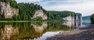
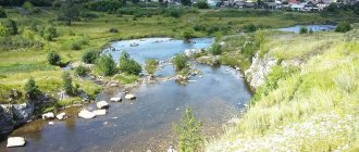
(Russian: Shimanovsk) is a city in Amur Oblast, Russia, located on the Bolshoi Pyörä River (with a right tributary from the Zeya), 250 km (160 mi) northwest of Blagoveshchensk. Population: 19,815 (2010 census); [2] 22,267 (2002 census); [8] 26,274 people (1989 census). [9]
History[edit]
It was founded in connection with the construction of the Amur Railway in 1910, originally named Pera in
honor the river on which it stands.
[ citation needed
] In 1914, it was renamed
Gondatti
in honor of the then governor of the Amur region, Nikolai Gondatti.
In 1920, it was renamed Vladimir-Shimanovsky in
honor of Vladimir Shimanovsky, a railway engineer and member of the Red Army, who was shot in Blagoveshchensk during the Russian Civil War.
It was given city status and its name shortened to Shimanovsk in 1950[ edit
]
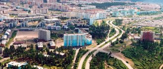
During the construction of the Baikal-Amur Mainline in the 1970s, Shimanovsk became a center for the production of building materials.
Shimanovsk
(Amur region)
OKATO code:
10440
Founded:
1910
Urban settlement since:
1929
City since:
1950 City of regional subordination
Center:
Shimanovsky district
The city was formerly called:
| Feather | 1910 | 1914 |
| Gondatti | 1914 | 1920 |
| Vladimiro-Shimanovsky | 1920 | 1950 |
| Telephone code (reference phone) | |
| 41651***** | 22-2-22 |
Deviation from Moscow time, hours:
6
Geographical latitude:
52°00′
Geographical longitude:
127°40′
Altitude above sea level, meters:
270 Sunrise and sunset times in the city of Shimanovsk
Climate[edit]
Monsoons influenced a humid continental climate ( Köppen climate classification Dwb
). The average January temperature is -25.6 °C (-14.1 °F). The observed absolute minimum was −49.0 °C (−56.2 °F). The average July temperature is +20.1 °C (68.2 °F).
During the transition period (April-May), strong winds of up to 20 m/s are occasionally observed. In winter the wind is weak. The average annual background atmospheric pressure is above normal, humidity is 50-60%, and there are at least 310 sunny days a year throughout the year.
| Climate data for Shimanovsk | |||||||||||||
| Month | Jan | Feb | Mar | Apr | May | Jun | Jul | Aug | Sep | October | But I | December | Year |
| Record high °C (°F) | -1,0 (30,2) | 2,7 (36,9) | 17,0 (62,6) | 26,7 (80,1) | 34,0 (93,2) | 39,1 (102,4) | 37,4 (99,3) | 35,0 (95,0) | 32,6 (90,7) | 27,4 (81,3) | 11,0 (51,8) | 0,0 (32,0) | 39,1 (102,4) |
| Average high °C (°F) | -18,5 (-1,3) | -12,8 (9,0) | -3,8 (25,2) | 7,8 (46,0) | 17,0 (62,6) | 23,9 (75,0) | 25,9 (78,6) | 23,3 (73,9) | 16,6 (61,9) | 6,1 (43,0) | -8,6 (16,5) | -17,8 (0,0) | 5,0 (41,0) |
| Daily average °C (°F) | -25,6 (-14,1) | -20,6 (-5,1) | -10,5 (13,1) | 2,0 (35,6) | 10,4 (50,7) | 17,5 (63,5) | 20,1 (68,2) | 17,4 (63,3) | 10,0 (50,0) | -0,3 (31,5) | -14,7 (5,5) | -24,1 (-11,4) | -1,5 (29,3) |
| Average low °C (°F) | -32,5 (-26,5) | -28,9 (-20,0) | -19,4 (-2,9) | -5,4 (22,3) | 2,2 (36,0) | 9,2 (48,6) | 13,2 (55,8) | 10,6 (51,1) | 2,8 (37,0) | -7,2 (19,0) | -21,4 ( -6,5 ) | -30,4 (-22,7) | -8,9 (16,0) |
| Record low °C (°F) | -49 (-56) | -46,1 (-51,0) | -37,2 (-35,0) | -23,9 (-11,0) | -8,5 (16,7) | -2,0 (28,4) | 1,2 (34,2) | -0,5 (31,1) | −10 (14) | -24 (-11) | -37,7 (-35,9) | -48,9 (-56,0) | -49 (-56) |
| Average precipitation, mm (inches) | 6,3 (0,25) | 8,3 (0,33) | 10,2 (0,40) | 28,8 (1,13) | 38,4 (1,51) | 78,6 (3,09) | 125,9 (4,96) | 84,0 (3,31) | 62,7 (2,47) | 24,9 (0,98) | 17,1 (0,67) | 10,7 (0,42) | 495,9 ( 19,52 ) |
| Average relative humidity (%) | 74,2 | 69,4 | 64,1 | 57,5 | 60,3 | 68,5 | 78,0 | 78,8 | 72,7 | 66,1 | 74,4 | 75,1 | 69,9 |
| Source: climbase.ru [10] | |||||||||||||
Map
| Shimanovsk: maps |
Shimanovsk: photo from space (Google Maps) Shimanovsk: photo from space (Microsoft Virtual Earth)
| Shimanovsk. Nearest cities. Distances in km. on the map (in brackets along roads) + direction. Using the hyperlink in the distance , you can get the route (information courtesy of the AutoTransInfo website) | |||
| 1 | Tsiolkovsky | 40 () | SE |
| 2 | Free | 75 (130) | SE |
| 3 | Novokievsky Uval | 93 () | SE |
| 4 | Seryshevo | 111 (176) | SE |
| 5 | Belogorsk | 133 (153) | SE |
| 6 | Vozzhaevka | 158 (168) | SE |
| 7 | Romny | 180 () | SE |
| 8 | Ivanovka | 182 (359) | YU |
| 9 | Blagoveshchensk | 191 (280) | YU |
| 10 | Zeya | 194 (304) | WITH |
| 11 | Magdagachi | 204 (263) | NW |
| 12 | Ekaterinoslavka | 205 (415) | SE |
| 13 | Tambovka | 212 (326) | YU |
| 14 | Zavitinsk | 243 (384) | SE |
a brief description of
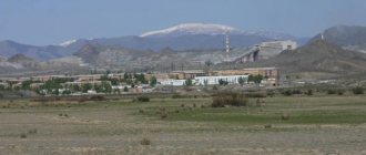
Located on the Amur-Zeya Plain, in the upper reaches of the river. Pera, 251 km north of Blagoveshchensk. Railway Shimanovskaya station. Road junction.
Territory (sq. km): 50
Information about the city of Shimanovsk on the Russian Wikipedia site
Historical sketch
Founded in 1910 as the station village of Pera in connection with the construction of the Trans-Siberian Railway. Name based on location in the upper reaches of the river. Bolshaya Pera (right tributary of the Zeya).
In 1914, a station was opened in the village, named Gondatti after the name of the ethnographer, private associate professor of Moscow University N.L. Gondatti (1861-1945), who in 1911-17. was the governor of the Amur region. The village received the same name.
In 1920, the station was renamed Shimanovsk, and the village was renamed Vladimiro-Shimanovsky in memory of the revolutionary V.I. Shimanovsky (1882-1918), executed in Blagoveshchensk. From 02/04/1929 the workers' settlement of Shimanovskaya, later - Shimanovsky.
In 1950 it was transformed into the city of Shimanovsk.
It developed intensively during the construction of the BAM as a base for the construction industry and a center for the production of building materials.
Economy
Factories: forging and pressing equipment, repair of road construction machines. Combines: "BAMstroyindustry" and woodworking.
Dairy, bakery.
Main enterprises
MECHANICAL ENGINEERING
OJSC "Kranspetsburmash"
676330, Amur region, Shimanovsk, st.
Plekhanov Offers:
Special crane drilling machines SKB-1, truck cranes with a capacity of 16 and 20 tons
Museums, galleries, exhibition halls
Shimanovsky Museum of Local Lore 676330, Amur Region, Shimanovsk, st. Pervomaiskaya, 10 Phone(s): (41651) 28-3616
Architecture, sights
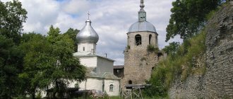
In the old part of the city, numerous wooden one-story houses from the early 20th century have been preserved. Modern development with multi-storey standard buildings.
| Population by year (thousands of inhabitants) | |||||||
| 1931 | 6.5 | 1996 | 26.0 | 2008 | 21.9 | 2017 | 18.7 |
| 1939 | 13.5 | 1998 | 25.7 | 2010 | 21.6 | 2018 | 18.6 |
| 1959 | 17.9 | 2000 | 25.1 | 2011 | 19.8 | 2019 | 18.5 |
| 1967 | 15 | 2001 | 24.9 | 2012 | 19.6 | 2020 | 18.6 |
| 1970 | 16.9 | 2003 | 22.3 | 2013 | 19.4 | 2021 | 18.5 |
| 1979 | 25.6 | 2005 | 22.1 | 2014 | 19.1 | ||
| 1989 | 26.3 | 2006 | 22.1 | 2015 | 18.9 | ||
| 1992 | 26.5 | 2007 | 22.1 | 2016 | 18.8 | ||
Links[edit]
Notes[edit]
- ^ abcdefg Law No. 127-OZ
- ^ a b Federal State Statistics Service (2011). “All-Russian Population Census 2010. Volume 1" [All-Russian Population Census 2010, vol. 1]. All-Russian Population Census 2010 [All-Russian Population Census 2010]
. Federal State Statistics Service. - "26. The size of the permanent population of the Russian Federation by municipalities as of January 1, 2022". Federal State Statistics Service. Retrieved January 23, 2022.
- ^ abc Law No. 12-OZ
- ^ abc Law No. 374-OZ
- "On the Calculation of Time". Official Internet portal of legal information
. June 3, 2011. Retrieved January 19, 2022. - Post office. Information and computing center of OASU RPO. ( Post office
).
Search for postal service objects ( postal Search for objects
) (in Russian) - ↑
Federal State Statistics Service of Russia (May 21, 2004).
“The population of Russia, the constituent entities of the Russian Federation as part of federal districts, urban settlements, settlements, settlements is 3 thousand or more people” [Population of Russia, its federal districts, federal districts, districts Urban settlements, rural settlements - administrative centers and rural settlements with a population of over 3,000] (XLS). All-Russian Population Census 2002
. - “All-Union Population Census of 1989. The current population of union and autonomous republics, autonomous regions and districts, territories, negative phenomena, urban settlements and rural district centers” [All-Union Population Census of 1989: current population of union and autonomous republics, Autonomous regions and districts , territories, regions, districts, towns and villages performing the functions of district administrative centers. All-Union Population Census of 1989 [All-Union Population Census of 1989]
.
Institute of Demography of the National Research University: Higher School of Economics [Institute of Demography of the National Research University: Higher School of Economics]. 1989 - via Demoscope Weekly
. - "Climatebase.ru - Simanovsk, Russia". 2011. Retrieved November 24, 2011.
Cities
Shimanovsk city
— the administrative center of the Shimanovsky district of the Amur region. The actual number of residents at the beginning of 2022 is about 18 thousand people.
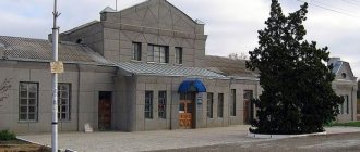
The city is located on the Bolshaya Pera River (a tributary of the Zeya), 251 km from Blagoveshchensk. The city is home to the Shimanovskaya railway station on the Trans-Siberian Railway.
Video clips about the city of Shimanovsk:
1) Shimanovsk past and present
2)City Day
History of the city Shimanovsk:
In 1910, a village was founded near the Pera railway; in 1914 it was renamed Gondatti in honor of the Governor-General of the Amur General Government (which included the Amur Region), ethnographer Nikolai Lvovich Gondatti (1860-1946).
In 1920, the station was renamed Shimanovsk, and the village Vladimir-Shimanovsky in honor of the revolutionary, railway engineer Vladimir Shimanovsky (1882-1918), who was shot during the Civil War in Blagoveshchensk.
In 1950, the village was given the status of a city and the modern name Shimanovsk.
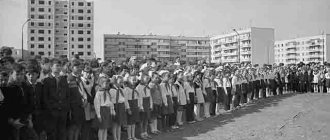
In 1972, the construction of a large industrial complex began, providing the necessary materials and structures for the construction of BAMA. The city's population increased to 26.5 thousand people. In 1982, a new airport was built and the railway was electrified.
Since 1975, Shimanovsk has been a city of regional subordination.
In 1982, a new airport was built and the railway was electrified.
Photo of the city Shimanovsk:
Economy of the city of Shimanovsk:
The basis of the economy is represented by: enterprises of railway transport, mechanical engineering, timber industry, trade, housing and communal services enterprises.
The main stage of the city's development occurred during the construction of the BAM. The city was one of the centers for the production of building materials for this project. The largest plant that has existed since that time is Bamstroyindustry (currently AOOT), located on Plekhanov Street. Bastroindustry produces concrete, reinforced concrete structures and wall blocks. The production of welded metal structures and forging and pressing devices in Shimanovsk is carried out by JSC Shimanovsky Forging and Pressing Equipment Plant. The Shimanovsky Sawmill and Woodworking Plant LLP produces window blocks, building panels, wood and wood-based parts, panel parquet and other wood products. The Shimanovsky forestry enterprise is engaged in the extraction and harvesting of timber. Created initially as an auto-repair plant for road-building machines and now operating, Shimanovsky Machine-Building Plant is the only enterprise in the Far East that produces lifts for special crane drilling machines and truck cranes. The plant also produces agricultural and forestry equipment, hot water boilers, sports facilities, and metal structures. As before, the plant carries out partial and major repairs of cars of all brands. There are also light food industry enterprises in Shimanovsk - a dairy plant and a bakery.
Education in the city of Shimanovsk:
In 2011, 138 graduates successfully graduated from high school, 7 graduates of secondary schools No. 2 and 4 received gold medals and 7 graduates of secondary schools No. 1,2,4 received silver medals.
Kindergartens in the city of Shimanovsk:
— Municipal preschool educational autonomous institution “Kindergarten No. 3 of a general developmental type with priority implementation of activities in the artistic and aesthetic direction of the development of children in the city of Shimanovsk”
— Municipal preschool educational institution “Kindergarten No. 6, Shimanovsk”
— Municipal preschool educational institution “Kindergarten No. 7, Shimanovsk”
— Municipal preschool educational institution “Kindergarten No. 8, Shimanovsk”
— Municipal preschool educational institution “Kindergarten No. 15 of a combined type, Shimanovsk”
— Municipal preschool educational institution “Kindergarten No. 16, Shimanovsk”
Unapproved coat of arms of the city of Shimanovsk.
Unapproved draft of the coat of arms of Szymanovsk
(compiled by A. Zhulay in 1991, used for souvenir badges in 2004): in the upper part of the shield in an azure field there is a golden ship on oars with a scarlet pennant on the bow and with two silver sails, of which the leading one, the larger one, is burdened with black with outstretched the wings of an eagle with a golden beak and paws, crowned with a golden crown, holding three golden arrows in its right paw, and a golden bow in its left; at the bottom of the shield in a green field on a brown bank near azure water there is a silver deer leaning towards it.