The Ivanovo region is located in the Central Federal District. More than 1 million people live on the territory of this subject of the Russian Federation. On the map of the Ivanovo region from a satellite you can see roads and railways, cities and small settlements. The main water bodies in the region are the Klyazma and Volga rivers. During navigation, river transport docks in the following cities:
- Kineshma;
- Yuryevets;
- Puchezh;
- Zavolzhsky.
Using a map of the Ivanovo region with diagrams, you can find 1,700 rivers and 150 lakes. The largest water body in the region is the Gorky Reservoir.
The Ivanovo region ranks second to last among all regions of the country in terms of territory - it is only about 24 thousand km2. Most of the people inhabiting it live in cities and only a little more than 20% live in rural areas. As the map of the Ivanovo region by district shows, the territory of the region is limited from different sides by 4 regions:
- Kostroma;
- Yaroslavskaya;
- Nizhny Novgorod;
- Vladimirskaya.
To get a complete picture of the location of cities, rivers, and transport routes in the region, you can move around the map with the mouse, zooming in or out and moving in the desired direction. A convenient online service can become an indispensable assistant for travelers, motorists, guests and residents of the region.
General information about the Ivanovo region
One of the smallest regions, located in the central part of Russia.
Representatives of the flora and fauna of the Ivanovo region are listed in the Red Book. The region is replete with expanses of water and numerous forested areas. Located in the central part of Russia. It occupies 21.4 thousand kilometers. It borders with four regions: Kostroma, Yaroslavl, Nizhny Novgorod and Vladimir. The length does not exceed 160 kilometers, and the width is only 230 kilometers. The central part of the region is most densely populated. Industry is concentrated here and large cities are built. This is also where the bulk of agricultural land is located.
Map of Ivanovo region with cities and villages
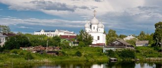
Moving around the map of the Ivanovo region with cities and villages, you can not only see the location of settlements, but also see their streets, houses and attractions. The most famous cities in the region through which the Golden Ring tourist route passes are Ivanovo, Plekh and Ples. But the most attractive is the city of Yuryevets and its main attractions:
- A. Tarkovsky Museum;
- five-tier bell tower;
- Mount Asaph.
The location of the city on the banks of a beautiful reservoir attracts not only lovers of historical monuments and connoisseurs of ancient Russian crafts, but also numerous fishermen who come here in whole companies.
Using a map of the Ivanovo region with villages, you can find another amazing settlement - the village of Kholui. Before the revolution, it was the center of icon painting in Russia. Icons painted in this village are exhibited in the most famous churches in the country. Currently, souvenir lacquer miniatures are made here, which tourists are happy to purchase.
Relief of the Ivanovo region
Occupies lands located in the central part of the East European Plain. The landscape is represented by plains with small hills, gradually turning into lowlands. There are no hills or mountains. There are many reservoirs on the territory of the Ivanovo region. These are mostly small lakes, some of which are swampy. The coastline is unclear during spring floods and is connected into a single surface of water with numerous tributaries and lakes.
Economy and industry of the Ivanovo region
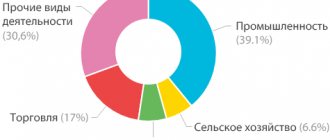
Economically, the region is considered one of the poorest regions of the country. The map of the Ivanovo region allows you to examine in detail the few industrial facilities. Of all types of industries, the following are developing here:
- light;
- mechanical engineering;
- food;
- energy;
- woodworking
The majority of production volumes are carried out by the textile industry. There are about 20 clothing factories in the region, which can be found using Yandex maps of the Ivanovo region.
Agriculture is also of great importance to the region. Here they grow potatoes, flax, grain, and engage in cattle breeding. The development of agriculture is facilitated by flat terrain and a large number of reservoirs.
One of the important components of the region’s economy is tourism. Every year the region is visited by more than a million pilgrims, tourists, and vacationers. On the banks of the Gorky Reservoir there are numerous recreation centers for eco-tourists. Connoisseurs of historical sights visit the cities and villages of the region, each of which has its own interesting and wonderful places.
Minerals of the Ivanovo region
The Ivanovo region is not replete with mineral deposits. The origin of the existing ones is sedimentary. There are studied deposits of phosphorites, a couple of developments of glass sands, building materials: clay, sand. The region has organized the production of building materials using its own raw materials. Underground reserves of fresh water and mineral springs have been discovered. There are reservoirs with medicinal table water.
Peat and sapropel are being developed and extracted.
Oil and gas of the Ivanovo region
Oil and gas deposits in the region were discovered in the 70s of the last century. But they were recognized as insignificant and unpromising, especially after the discovery of the Tyumen deposits.
Climate of the Ivanovo region
The climate is characterized as moderate continental: without sharp temperature fluctuations. At the same time, cyclones and weather changes are frequent. The climate is influenced by air masses originating in the Atlantic. Winters are quite mild with slight temperature fluctuations. Summer is also not very hot, but it is uniformly warm. The coldest month is January, with an average monthly temperature of about -12 degrees. The warmest month is July, but there are no significant temperature changes. The monthly average is about +17 degrees. The thickness of the snow cover can reach 50 centimeters; soil freezing occurs to a depth of 45 centimeters. Annual precipitation rarely exceeds 600 millimeters. Spring and autumn with moderate precipitation and a uniform decrease and increase in temperature. Melting snow and ice significantly increases water levels in reservoirs.
Ivanovo
Video: Ivanovo
Basic moments
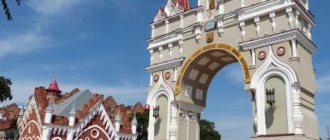
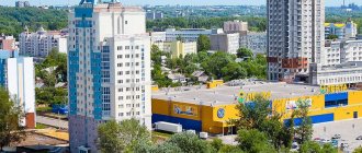
The first mention of Ivanovo dates back to the 16th century. The founding date of Ivanovo is 1871 - it was in this year that the village of Ivanovo and Voznesensky Posad united. Unfortunately, the city has practically no surviving buildings dating back to the 16th century, but you should come to Ivanovo to admire the architecture of the late 19th-20th centuries. In particular, buildings dating back to the era of constructivism of the 20-30s are interesting. XX century, as well as mansions built in the Art Nouveau style.
Ivanovo today is part of the Golden Ring of Russia. From a tourist point of view, the city of Ivanovo is interesting for its attractions, such as the Shudrovskaya tent, the house-ship built in 1930, and the horseshoe house built in 1934. Interestingly, there is a circus in Ivanovo, a visit to which can also become one of the memorable events in Ivanovo.
There are approximately 27 hotels of various categories in Ivanovo, almost all of them are concentrated in the city center. Tourists in Ivanovo also have excellent restaurants and bars in the city.
Climate
The climate of Ivanovo belongs to the temperate continental type. As a rule, the coolest weather in Ivanovo occurs in January, at which time the air temperature in Ivanovo drops to -12 °C. It is warmest in Ivanovo in July, at which time the air warms up to +18.7 °C.
Attractions
Sights of Ivanovo include various architectural monuments, museums and other interesting objects.
In particular, such sights of Ivanovo as the Shchudrovskaya Tent - the oldest brick building in the city, the Ship House, designed by architect Friedman, and the buildings of the Ivanovo-Voznesensk Polytechnic Institute are interesting.
The religious attractions of Ivanovo include the Holy Vvedensky Convent, the Transfiguration Cathedral, the Church of the Holy Apostle, etc.
Also interesting are such sights of Ivanovo as the Burylinskaya library, which houses a rare and rich collection of all kinds of books, the house-museum of the artist Morozov, as well as the house-museum of the Bubnov family with a beautiful mezzanine.
We also recommend that tourists visit the Burylin Museum of Industry and Art.
Excursions
First of all, we recommend that tourists go on a sightseeing tour of Ivanovo, during which you can see the main attractions of Ivanovo - the Shchudrovsky tent, the Holy Vvedensky Monastery, the Duringer estate, etc.
Also interesting is an excursion from Ivanovo to Palekh and Shuya, during which you can touch the magical world of Russian art.
Story
The first mention of Ivanovo dates back to 1561: according to legend, Ivan the Terrible granted the village of Ivanovo and its adjacent villages to the Temryukovich-Cherkassky princes. At the beginning of the 17th century, Ivanovo was devastated by Polish-Lithuanian invaders. After this, it is reborn as a large commercial and industrial village.
In the 17th century, textile manufactories appeared here, and the village became the center of the linen industry.
In the first half of the 18th century, Ivanovo became a large fishing and trading village.
In 1705, by decree of Peter I, a customs hut was established here to collect various duties on trade to the treasury.
In the 18th century, cotton and calico printing production emerged in Ivanovo. The oldest civil stone building in Ivanovo dates back to the same century, which originally served as a hut and then came into the possession of the merchant Osip Shchudrov.
Since the end of the 18th century, on the southeastern outskirts of the village there was the Assumption Cemetery, where in 1815 a wooden church was moved from the former Intercession Monastery. In 1834, a new stone Assumption Cemetery Church with chapels of the Nativity of John the Baptist and Barbara the Great Martyr was built. Some of the icons were transferred from the wooden church.
In 1901, the Vvedenskaya Church was founded, which 90 years later became the Holy Vvedensky Convent.
Accommodation
Ivanovo hotels are presented on this page in the form of an objective rating based on reviews from tourists. So where to stay while on vacation in Ivanovo? You can easily find the answer here: all Ivanovo hotels are located below under the resort map in a table format convenient for tourists, which can be sorted by hotel name, by their star rating, by popularity (number of reviews), as well as by the average rating of tourists. in the reviews they leave. The description of each Ivanovo hotel contains its photographs in large format, a list of services available to hotel guests, hotel contact information, a map of Ivanovo with the hotel location, as well as detailed reviews from tourists.
Sports and active recreation
Active recreation in Ivanovo includes cycling, walking around the city, and bowling, for example, at the Volga club.
Also in Ivanovo, the Olympia entertainment and ice complex has been operating since 2008, and the Lokomotiv, Tekstilshchik, Burevestnik and Spartak stadiums have been opened.
Let us add that in Ivanovo there is a football team “Textilshchik” and a women’s basketball team “Energia”.
Transport
Public transport in Ivanovo includes trolleybuses, buses and minibuses, as well as just a taxi, which can be called from any hotel in Ivanovo.
Note that the trolleybus appeared in Ivanovo in 1962, the tram existed in Ivanovo from 1934 to 2008.
Souvenirs
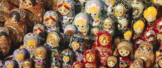
Souvenirs from Ivanovo are, first of all, various woven products - pillows, aprons, tablecloths, napkins, etc. Secondly, don’t forget about traditional refrigerator magnets and cups, saucers and plates with views of Ivanovo. Also interesting are such souvenirs from Ivanovo as brightly decorated nesting dolls, whistles and other products of Ivanovo craftsmen.
Interesting Facts
- Ivanovo is called the “city of brides”, “calico land” and “Russian Manchester”.
- In 1579, the owners of the village built the Intercession Monastery near it. The peasants of the village of Ivanovo were engaged in arable farming, crafts, and trade.
- In 1742, peasant Grigory Butrimov founded the first manufactory in the village.
- In 1815, by decree of the Vladimir Spiritual Consistory, the Trinity Church with the chapel of Barbara the Great Martyr was moved to the Assumption Cemetery and consecrated in 1817 in honor of the Dormition of the Mother of God. Over time, the wooden church fell into disrepair. In 1849, the chapel of Barbara the Great Martyr was broken, and in 1883, services ceased. In 1904, the manufacturer and founder of the city museum D. Burylin moved the temple from the old Assumption Cemetery to the new Posad Cemetery. In 1906, the restored church was opened. In 1946, it was handed over to the Old Believers community and consecrated in honor of the icon of the Kazan Mother of God.
How to get there
There are several ways to get to Ivanovo from Moscow:
- By bus. Buses from Moscow to Ivanovo start from Shchelkovsky station, travel time is just over 5 hours.
- By train. Travel time on the Moscow-Kineshma train is just over 7 hours.
- By plane. Flights are carried out by air, travel time is 1 hour.
- By car. The distance between Moscow and Ivanovo is 297 km, travel time will be approximately 4.5 hours.
Inland waters of the Ivanovo region
The waterways of the Ivanovo region number 50 rivers exceeding 25 kilometers and many small rivers that feed them. The largest river in the region is the Volga. The number of streams and small tributaries exceeds 1,700. Spring floods cause severe overflow, flooding of floodplains and lowlands. All rivers belong to the Klyazma River basin. The largest rivers are Uvod, Teza, Nerl, Lukh. The largest reservoir is located on the Volga - Gorkovskoye.
The territory of the Ivanovo region is replete with small lakes and swamps. The latter accounts for 1.4 thousand square kilometers. There are a little more than 150 lakes, most of them are located in the south and central part of the region. Not all lakes are of natural origin. Some of them are formed as a result of the extraction of peat and sand. The peat bogs formed by the extraction of raw materials account for more than 45 thousand hectares.
Take away
The river on which the administrative center is located - the city of Ivanovo. The length of the river is 185 kilometers. It flows through the Ivanovo and Vladimir regions. The river is not navigable, rather shallow. Previously used for industrial purposes. Upstream there is a large reservoir - Uvodskoye. Downstream it flows into the Klyazma.
Districts of Ivanovo region on the map
You can view all the districts in detail on the map of the Ivanovo region. They are approximately the same in area, but differ in the number of people living. In total, the region is divided into 21 districts, the most densely populated of which are:
- Ivanovsky:
- Kineshemsky;
- Shuisky.
The fewest people live in the Savinsky district, which is located on the southern border of the region. And the Ivanovo district, with its administrative center - the city of Ivanovo, is traditionally considered the weaving center of the country.
To move around the region from one area to another, the population uses road, rail and water transport. A detailed road map of the Ivanovo region will help you find the main transport arteries of the region, routes:
- M-7 "Volga";
- R-600;
- R-79.
In total, there are about 5,000 km of asphalt roads in the region. A few years ago, a large road bridge was built across the Gorky Reservoir in the Kineshma region.
On the map of the Ivanovo region with settlements you can find railway stations and train stations. The largest railway depot in the region is located in Ivanovo.
From a tourist point of view, the most interesting are the Shuisky and Yuryevetsky districts. Around the city of Shuya there are several ancient, beautiful monasteries that attract pilgrims. The main historical and architectural monuments are located in the Yuryevets district.
Forests of Ivanovo region
In the Ivanovo region there is a mixture of vegetation characteristic of the taiga zone and mixed forests. Forest vegetation occupies almost half of the entire territory of the region. The northern and northeastern regions are represented by coniferous flora: spruce, pine. There are artificial plantings of Sukachev larch. Gradually, in the southern direction, deciduous forests begin to predominate, forming groves and copses. The transition between zones is smooth. Birch, linden, alder, aspen are the most common trees. There are small oak groves. The undergrowth and copses are filled with mountain ash, hazel and buckthorn bushes. Part of the territory occupied by swamps and river lands is occupied by shrubs and alder. The territory occupied by meadows is no more than 10%.
The lower tier of forests is formed by wild berries: lingonberries, blueberries, cloudberries, blueberries, many mushrooms, wild rosemary. Cranberries grow in the swamps.
Brief description of the Ivanovo region
INTRODUCTION
Ivanovo Region is an administrative-territorial unit in the European part of Russia, a subject of the Russian Federation, part of the Central Federal District. In the north-west it borders with the Yaroslavl region, in the north with the Kostroma region, in the east with the Nizhny Novgorod region, in the south with the Vladimir region.
The climate of the region is moderate continental. It is characterized by relatively warm summers and moderately frosty winters with stable snow cover. The coldest month of the year is January with an average monthly temperature of -11.5º...-12ºС, the warmest month of summer is July with an average monthly temperature of +17.5º...+18ºС. Precipitation is about 550 – 800 mm per year.
COMPOUND
Administratively, the region includes 21 municipal districts. The regional center is the city of Ivanovo with a population of 406.5 thousand people; the number of residents in regional centers varies widely: from 92.4 thousand people in the city of Kineshma to 2.0 thousand people in the village. Upper Landeh. The rural population is 207.3 thousand people, or 19.2% of the total.
The territory of modern Ivanovo region became part of the Moscow state in the 15th century. In 1778, this territory was divided between the Kostroma and Vladimir provinces. In 1918, the region became part of the Ivanovo-Voznesensk province, and in 1929 the Ivanovo industrial region was formed. In 1936, the Ivanovo region was founded.
On a detailed satellite map of the Ivanovo region you can see such natural attractions as the Klyazmensky reserve and the Volga River.
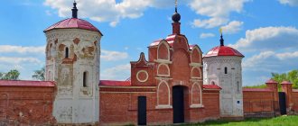
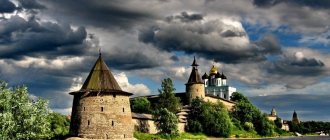
On the territory of the Ivanovo region there are three cities that are part of the Golden Ring of Russia - Ivanovo, Plyos and Palekh. Numerous architectural monuments have been preserved in these cities. It is worth visiting the Assumption and Holy Vvedensky monasteries in Ivanovo, the Assumption Cathedral, the Trinity, Resurrection and Vvedensky churches in Plyos, the Elias and Holy Cross churches in Palekh.
In addition, it is worth visiting the historical cities of Kineshma, Vichuga and Yuryevets. In the Ivanovo region, it is recommended to visit the Nikolo-Shartomsky Monastery in the village of Vvedenye, the Ivanovo chintz museum in Ivanovo, the St. Tikhon-Lukhsky Monastery in the village of Lukh, the Holy Dormition Monastery in Dunilovo and the Alekseevskoye estate (Nogino), which is a miniature copy of Peterhof.
NATURAL RESOURCE POTENTIAL
According to the nature of the relief, the territory of the region is a plain with absolute elevations on average 100 - 130 m above sea level, evenly and shallowly dissected by river valleys, ravines and numerous wide hollows. The greatest contrast in relief is observed between the elevated northwestern part, where the Galich-Plesskaya moraine ridge passes, and the southeastern edge of the Balakhninskaya lowland. The extreme southeast of the region covers the northwestern part of the Balakhna lowland with elevations of 75-85 m, which is a flat sandy plain with a large number of small lakes, peat bogs and largely covered with forest. In the southern regions of the region, karst phenomena occur, presented in the form of funnels, sinkholes and depressions of karst lakes.
The river network belongs to the basin of the Volga River and its right tributary, the Klyazma River. In the north of the region there are forests of the southern taiga type, in the south - mixed. Swamps are widespread in the northwestern and southern parts of the region.
The surface of the region was formed mainly under the influence of glaciers and represents a low-lying, slightly hilly plain, elevated above sea level by 100 - 150 meters or more. Only in the northern and northwestern parts of the region is there a slight elevation of the relief. The highest point of the region - 196 meters above sea level - is located in the Zavolzhsky district.
The southern part of the region is low-lying, dissected by the valleys of the Teza, Klyazma, Vyazma, Lukha rivers and their tributaries. On the flat sandy plain there are many small lakes, peat bogs of glacial and karst origin.
The region is located at the junction of two zones: European taiga and mixed forests. Forests occupy 50.9% of the region's territory, meadows - 10%.
The Ivanovo region is located in the central part of the Russian Platform, within the Moscow syneclise. On its territory there are two structural floors: a crystalline foundation and a sedimentary cover. The basement surface within the region plunges in a northern and northeastern direction from 2200 to 3000 m.
The geological structure of the sedimentary cover - to the maximum depth of technogenic impact within the region - is represented by deposits of the Carboniferous, Permian, Triassic, Jurassic, Cretaceous, Neogene (locally) and Quaternary systems.
The Ivanovo region is not rich in a variety of minerals. However, more than 600 deposits of non-metallic minerals have been explored on its territory - mainly sand, gravel and peat. In addition, 74 deposits of fresh groundwater and 12 deposits of mineral groundwater have been explored in the region.
The soils of the Ivanovo region were formed mainly from sands and clays. The soil type is soddy-podzolic with a small amount of humus. Such soils are unsuitable for growing cultivated plants. In the fields of the region, mainly grain crops are grown such as rye, barley, oats, and vegetables - potatoes, carrots, cabbage.
There are about 1,700 rivers and streams and more than 150 lakes in the region. The largest river is the Volga with the Gorky Reservoir located in its waters.
The river network belongs to the Volga and Klyazma river basin. In the north of the region there are forests of the southern taiga type, in the south - mixed. Swamps are widespread in the northwestern and southern parts of the region.
The favorable geographical location of the region contributes to the development of internal and external economic and cultural relations. Important highways, railways and waterways pass through it, connecting the eastern regions of the country.
Due to the low level of production, the region has a fairly high environmental rating, which is very important in modern conditions. It is one of the most environmentally favorable regions of Russia and has the richest recreational opportunities, which include water, forest resources, landscapes and healing springs.
POPULATION AND LABOR RESOURCES
The total population of the region is about 1.2 million people.
Administratively, the region includes 21 municipal districts. The regional center is the city of Ivanovo with a population of 406.5 thousand people; the number of residents in regional centers varies widely: from 92.4 thousand people in the city of Kineshma to 2.0 thousand people in the village. Upper Landeh. The rural population is 207.3 thousand people, or 19.2% of the total.
The trend of population decline in the region continues. The reason for the reduction is a negative trend in the process of natural reproduction. In 2002, natural decline was 13.3 per 1000 population. The migration influx, which characterizes the mechanical movement in the region, cannot compensate for such a high loss. Natural population decline in 2002 covered the entire territory of the region. In Puchezhsky, Teykovsky, Komsomolsky, Pestyakovsky and Zavolzhsky districts, natural losses amounted to more than 18 people per 1000 population. The average age of the population at the beginning of 2003 was 40.2 years. The total fertility rate remains very low - 1.1. For normal reproduction, this indicator must be at least 2.15. In 2002, 9,607 babies were born in the region. The birth rate was only 8.1 births per 1000 population. It should be noted that, according to this indicator, our region is out of the top five regions of Russia with the lowest birth rates. Migration population growth has continued to decline in recent years. In 2002, the region's population was replenished by migrants from the CIS and Baltic countries. Most of the migration influx with the countries of the former republics of the USSR is formed due to migration with Kazakhstan, Uzbekistan and Ukraine. The bulk of migration flows are made up of Russians, who account for 89.3% of arrivals and 87.3% of departures. In the Ivanovo region, the number of children is decreasing, mortality exceeds the birth rate. According to the statistics body, the number of permanent population in the Ivanovo region as of January 1, 2006 amounted to 1 million 99 thousand 900 people, having decreased by 14 thousand 700 people in 2005. The birth rate last year remained at the 2003 level and amounted to 8.7 per thousand population (in 2004 - 9). Last year, 24 thousand 401 people died in the region, and this figure has remained virtually unchanged since 2001. The mortality rate is constantly growing: in 2005 - 22 per thousand population (in 2004 - 21.6). The infant mortality rate is high - 10.7 per thousand births. In 2005, the civil registry office registered only 6 thousand 446 births (65.2 percent of the total number) of children born to women in registered marriages, in 2004 - 67.9 percent. In 2007, 37 million 383 thousand rubles were allocated in the regional budget for the implementation of the program “Children of the Ivanovo Region for 2007 - 2009”, and in total during the three years of its operation - 152 million 171 thousand 800 rubles. The Federal Target Program “Children of Russia” is also being implemented. In 2006, the region's birth rate increased—255 more children were born than in 2005. 2007 in the Ivanovo region is called the year of mother and child. In addition, a program is being implemented in the Ivanovo region to prevent the growth of social orphanhood and the development of family forms of raising orphans. As Mikhail Men reported, as of December 1, 2006, the number of children placed in families increased by 20% compared to the previous year. The number of children placed in foster care increased by 27%. The region also has a program of patronage of business communities for orphanages and boarding schools. The permanent population of the Ivanovo region at the beginning of 2003 was 1176.2 thousand people, including the urban population of 971.3 thousand people and the rural population of 204.9 thousand people. The largest settlements: Ivanovo (440.9 thousand people), Kineshma (97.0 thousand people), Shuya (64.0 thousand people), Vichuga (43.5 thousand people). The average population density is 55.1 people/km2. The economically active population accounts for 592 thousand people, or 50.3%. However, according to the territorial statistics body, in the first half of 2007 the downward trend in the population of the Ivanovo region continued. Since January 2007, it has decreased by 4,855 people. Meanwhile, according to statistics, the mortality rate is decreasing. Compared to the first half of 2006, it decreased by 9.8%. Meanwhile, the birth rate is rising. Over 6 months of 2007, 5,075 babies were born in the Ivanovo region, which is 240 more than during the same period in 2006. As of January 1, 2008, 1 million 79.6 thousand people permanently lived in the region. In January-May 2008, the birth rate continued to increase in the region. The total fertility rate increased by 7.5% compared to the corresponding period last year (2007). Along with natural population losses in the region, there is an increase in migration; in January-May 2008 it amounted to 1,676 people. In the first quarter of 2008, 2,545 babies were born in the Ivanovo region, which is 167 more children than in the same period in 2007. In 2006, the region approved the composition of the commission on demographic policy under the governor, the main task of which is to coordinate the activities of government bodies and non-governmental organizations in the formation and implementation of demographic policy in the region. In the Ivanovo region, a program is being implemented to prevent the growth of social orphanhood and the development of family forms of raising orphans. As Mikhail Men reported, as of December 1, the number of children placed in families increased by 20% compared to the previous year. The number of children placed in foster care increased by 27%. There is a program of patronage of business communities for orphanages and boarding schools in the region.
Fauna of the Ivanovo region
There are over fifty representatives of mammals on the territory of the Ivanovo region. Some of them are listed in the country's Red Book. The Russian muskrat and the giant bat are the most prominent representatives.
The Ivanovo region abounds in hares, martens, squirrels, foxes and moose. Hunting is allowed. Minks are found in the wild. Predators include bears and wolves. There are several species of deer in the forests. There are badgers, beavers, roe deer, muskrats and raccoon dogs. Hunting is allowed for more than 70 species of animals.
There are many small rodents in the meadows and undergrowth, including shrews and moles.
Brown bears, muskrats, and lynx are included in the Red Book.
Birds of the Ivanovo region
A large number of forests are a favorable place for nesting of all kinds of birds. There are more than two hundred species of birds that have chosen the Ivanovo region for breeding chicks. 22 of which are listed in the Red Book. These are osprey, white-tailed eagle, golden eagle, peregrine falcon, steppe eagle and many others.
The most common inhabitants among birds are wood grouse, owls, thrushes, woodpeckers, numerous passerines, jackdaws, crows, and tits. More than 25 species of birds are not permanent residents of the region - they migrate, stopping here only for nesting.
Birds of the Ivanovo region are divided into:
- sedentary, permanent residents (tits, jackdaws, hooded crows, pigeons),
- migratory or insectivorous (swallows, orioles, cuckoos, swifts),
- nomadic (bullfinches, waxwings, long-eared owls),
- wintering, arriving only in winter (brown buzzard, snow bunting),
- migratory birds (geese, ducks, waders),
- vagrants, once noted by ornithologists within the region (steppe eagle, little auk, cormorant).
"City of Brides" and "Russian Manchester"
This is what Ivanovo-Voznesensk was called (this was the name the city of Ivanovo had until 1932) in the Russian Empire. Flax and hemp grow well on the loamy soils of the Ivanovo region. Thanks to the availability of raw materials, Ivanovo-Voznesensk became the largest textile center in Russia, maintaining its status both in the USSR and in post-Soviet times. The glory of the “city of brides” that has developed behind this beautiful Central Russian city is also understandable. The demand for the seamstress profession in Ivanovo is stable, so girls from all over the country went to the city on Uvodi to work as weavers and dressmakers. But it cannot be said that the gender balance in Ivanovo is heavily skewed towards the fair sex. Rather, the “city of brides” is a brand of the 37th region.
In the Russian Empire, Ivanovo-Voznesensk was not a provincial city, and not even a district one - it belonged to the Shuisky district of the Vladimir province and was the largest provincial city in the Empire. Now Shuya is the regional center of the Ivanovo region. The Ivanovo region itself was created in several stages - through the creation of the Ivanovo industrial region and its division. Now the Ivanovo region includes areas of the former Vladimir and Kostroma provinces. The final boundaries of the Ivanovo region were formed in 1994, when the Sokolsky district, separated from the rest of the region by the Gorky Reservoir, became part of the Nizhny Novgorod region. For more than 10 years, in order to call from Nizhny Novgorod to Sokolskoye, you had to dial the Ivanovo intercity code, and the registration plate of region 37 in Sokolskoye is not so rare. The transport infrastructure of the Ivanovo region has great prospects for development. Its main hubs are Ivanovo and Kineshma. The kilometer of highways in region 37 is 5,244 km, of which 5,017 km are paved. Despite the fact that the Ivanovo region is located quite advantageously for transit - it borders the Nizhny Novgorod, Vladimir, Kostroma and Yaroslavl regions, “region 37” is not yet using its potential sufficiently. However, thanks to the commissioning of the bridge across the Volga in Kineshma, the Ivanovo region has great prospects as a transit region between Siberia and the Far East, the Middle and Lower Volga region, on the one hand, and the North and North-West of Russia, on the other.
Map — Ivanovo region
River inhabitants of the Ivanovo region
The presence of a network of waterways and numerous lakes is a favorable place for waterfowl. There are a lot of ducks, geese, river muskrats, and beavers. Duck hunting opens in the spring, and geese hunting in the fall. The most common fish in reservoirs are pike, sabrefish, roach, crucian carp, tench and bream. The rivers are inhabited by sturgeon and beluga. In total, more than 45 species of different fish have been recorded.
The otter, European grayling, and river trout are listed in the Red Book.
There are few species of amphibians and reptiles, but they live in large numbers. The grass frog is the most famous representative, which is found almost everywhere.
Protected areas of the Ivanovo region
In total, there are more than 700 areas in the Ivanovo region that have protected status. They are allowed to visit for the purpose of recreation and tourism. These objects include lakes, more than thirty swamps, forests, parks, reservoirs, single trees and many other attractions. There are five nature reserves in the Ivanovo region, the largest being Mirslavsky. One of the reserves, Klyazmensky, has federal status.
Klyazmensky reserve
A protected natural area, which is part of the Meshchera protected park. It occupies an area of 21 thousand hectares. The lands included in the reserve are located in two regions: Ivanovo and Vladimir. Founded in 1978. Formed by the floodplains of three rivers. The territory consists of many lakes, marshy areas, and unique vegetation, a bit reminiscent of Karelian landscapes. The predominant vegetation is pine, birch, oak, and maple. Lots of lingonberries, blueberries, heather. Swampy soils abound with mosses.
A diverse fauna, mainly with a halo of habitat near water bodies: muskrat, beaver, marten, several species of ducks. Black grouse, wood grouse, and hazel grouse live here. There is a unique bird, the white-tailed eagle. More than twenty species of animals live here.
Zavolzhsky reserve
The forest area predominates, which serves as a habitat for moose, hares, foxes, and wild boars. Lynxes and wolves and brown bears are also found here, but not often. This is a favorable habitat for black grouse, wood grouse, and hazel grouse.
Uvodskoye Reservoir
One of the largest reservoirs supplying the region with water is located on the Uvod River in the Ivanovo district. It represents a natural complex in which more than 14 species of fish coexist: pike, roach, ide, saberfish, mustard, roach, crucian carp and many others. The coastline is not very indented and is framed by mixed forests. Part of the coast abuts meadow areas, which are flooded when there is a flood.
Gorky Reservoir
Formed by a hydroelectric dam on the Volga River. It has another name - the Gorky Sea (Grief-Sea). This is due to bizarre weather changes and the sudden appearance of two-meter waves. The right side of the reservoir is navigable, although the average depth is slightly more than 3.6 meters. Connects four regions: Ivanovo, Kostroma, Nizhny Novgorod and Yaroslavl.
A real paradise for fishermen: bream, carp, pike, crucian carp are found here. There are many recreation centers on the coast.
Ivanovo region
The Ivanovo region is located in the center of the European part of Russia. Most of it lies between the Volga and Klyazma rivers. Area - 21,437 km² (one of the smallest regions of Russia, larger only than Kaliningrad). It borders on the Vladimir, Nizhny Novgorod, Kostroma and Yaroslavl regions. The length of the territory from north to south is 158 km, from west to east – 230 km.
The surface of the Ivanovo region is a gently undulating, sometimes flat, low-lying plain, the absolute height of which reaches 212 m above sea level (Moscow Upland, near the border with the Vladimir region). The lowest point of the region - 75 m above sea level - is located on the banks of the Klyazma River.
The Ivanovo region is located in the center of the East European Plain. From a tectonic point of view, this is a calm platform area located under the southern wing of the Moscow depression. The depth of the crystalline basement varies from 1600 m in the south to 3000 m in the north of the region.
The region is located at the junction of two zones: European taiga and mixed forests. In total, forests occupy 48% of the region's territory, and meadows about 10%. Especially the forested Zavolzhsky, Yuzhsky and Teykovsky districts.
In 1972, the flora of the region included almost a thousand species of wild and cultivated plants.
In 2005, the forests of the Ivanovo region occupied 1037.5 thousand hectares, or 48% of the total area. The share of coniferous forests was 46% of the forested area, young forests 28%, middle-aged 37%, ripening forests - 20%, mature and overmature forests - 15%.
The number of species of terrestrial invertebrate animals in the Ivanovo region is estimated at 100-120 thousand. The integrated database of vertebrate animals of Russia includes species and subspecies of 295 freshwater fish, 29 amphibians, 84 reptiles, 739 birds and 310 mammals. More than 377 species of vertebrate animals are found on the territory of the Ivanovo region, which is about 26% of the total (excluding “marine” fish of which there are about 3000 species in Russia) diversity of vertebrate animals in Russia. Vertebrates are represented by the following classes: cyclostomes; bony fish; amphibians; reptiles; birds; mammals. The most numerous species in terms of the number of species are bony fish (about 50 species), birds (about 250 species) and mammals (about 60 species).
Fish, birds and mammals are of greatest economic importance. Currently, commercial fish in the region include 20 species: bream; pike; zander; asp; burbot; catfish; saberfish; ide; perch; roach; white-eye; bersh; silver bream; tench; carp (domesticated form); carp (wild form); goldfish; blue; sprat; bleak. The territory of Ivanovskaya is home to 76 species of fauna classified as hunting resources (50 species of birds and 26 species of mammals). The main objects of hunting are: elk, wild boar, bear, martens, fox, hares, beaver, mink, muskrat, wood grouse, black grouse, hazel grouse, various types of geese, ducks and waders.
Agricultural activities in the Ivanovo region
The predominant direction is livestock farming with meat and dairy areas. Pig and poultry farming is actively developing. In the region they breed sheep and goats.
The Ivanovo region belongs to the risky farming zone. Some lands are subject to water erosion, others have high acidity, and a significant part of the land is swampy. Only 70% of the region's agricultural land is occupied by arable land. Perennial grasses are grown for livestock feed; grains account for about 27%. Potatoes, rye, barley, and flax are planted in the region.