City in Khabarovsk Krai, Russia
| Nikolaevsk-on-Amur Nikolaevsk-on-Amur | |
| Town[1] | |
| Flag Coat of arms | |
| Nikolaevsk-on-Amur | |
| Nikolaevsk-on-Amur Nikolaevsk-on-Amur Show map of Russia Nikolaevsk-on-Amur Nikolaevsk-on-Amur (Khabarovsk Territory) Show map of Khabarovsk Territory | |
| Coordinates: 53°08′N 140°44'E / 53.133°N 140.733°E / 53.133; 140.733Coordinates: 53°08′N 140°44'E / 53.133°N 140.733°E / 53.133; 140.733 | |
| A country | Russia |
| Federal subject | Khabarovsk region[1] |
| Based | August 13, 1850 |
| City status from | 1856 |
| Government | |
| • Head | Peter Volynsky |
| Height | 30 m (100 ft) |
| Population (2010 Census)[2] | |
| • Total | 22,752 |
| Administrative status | |
| • Subordinate | city of regional significance Nikolaevsk-on-Amur[1] |
| • Capital from | town of regional significance Nikolaevsk-on-Amur[3], Nikolaevsky district[4] |
| Municipal status | |
| • Municipal district | Nikolaevsky municipal district[5] |
| • Urban village | Urban settlement Nikolaevsk-on-Amur[5] |
| • Capital from | Nikolaevsky municipal district[6], urban-type settlement Nikolaevsk-on-Amur |
| Timezone | UTC + 10 (MSK + 7 [7]) |
| Postal code(s)[8] | 682460 |
| Dial code(s) | +7 42135 |
| OKTMO I WOULD | 08631101001 |
Nikolaevsk-on-Amur
(Russian: Nikolaevsk-on-Amur,
Nikolaevsk-on-Amur
) is a town in Khabarovsk Krai, Russia located on the Amur River close to its estuary into the Pacific Ocean. Population: 22,752 (2010 Census);[2]28,492 (2002 Census);[9]36,296 (1989 Census).[10]
Story
Medieval and early modern history
During the late Middle Ages, the people living along the lower reaches of the Amur (Nivkhsky, Oroch, Evenki) were known in China as the “wild Jurchens”. Yuan Dynasty The Mongols sent expeditions to this area with an eye to using the region as a base to attack Japan or to defend against the Sakhalin Ainus. According to the History of the Yuan, in 1264 the Nivkhs recognized Mongol rule. In 1263, the Mongols established the "Command Post of the Marshal of the Eastern Campaign" near the modern settlement of Tyur, about 100 kilometers (62 miles) upstream from today's Nikolaevsk-on-Amur. Around the same time, a temple was built on the rock of Tire.[11][12]
From 1411 to 1433, the Ming eunuch Ishikha, a man of Haixi Jurchen origin, led four large missions to win the allegiance of the "Jurchen" tribes along the Songhua and Amur rivers. At this time, the Yongning Temple was built in Tire and steles with inscriptions were erected.[11]
Russian period
View of Nikolaevsk, approx.
1900 Russian settlement, probably preceded by the Manchu village of Fuyori,[13] was founded as the Nikolaev Post Office by Gennady Nevelskoy on August 13, 1850[ citation needed
] and named after Tsar Nicholas I.[14]
The village quickly became one of the main economic centers of the Pacific coast of the Russian Empire. It became Russia's main Pacific harbor (replacing Petropavlovsk) in 1855 after the Siege of Petropavlovsk in 1854. It received city status and was renamed Nikolaevsk-on-Amur in 1856, when Primorsky Oblast was established.[ citation needed
] Admiral Vasily Zavoiko supervised the construction of a naval base in Nikolaevsk-on-Amur.
The city developed into an important trading port; however, due to navigational difficulties caused by sandbanks in the Amur Estuary and sea ice, the port became unusable for five months of the year, and the main Russian shipping operations in the Pacific were moved to Vladivostok in the early 1870s. The city remained the administrative center of this region until 1880, when the governor moved to Khabarovsk. Anton Chekhov, who visited the city during his trip to Sakhalin in 1890, noted its rapid decline in population, although this trend slowed somewhat in the late 1890s with the discovery of gold and the establishment of the salmon fishery.
During the Russian Civil War in 1917-1922. The city's population dropped from 15,000 to 2,000 as a local partisan leader, later executed by the same Bolsheviks he was supposed to be associated with, razed the entire city and exterminated the minority of the Japanese population along with most of the Russian population.
Around 1940 the Gulag System was located in the city.[15]
Like many other places in the Russian Far East, the city's population has declined since the collapse of the Soviet Union, falling from 36,296 residents recorded in the (1989 Census),[10] to 22,772 in 2010.[2]
Map
| Nikolaevsk-on-Amur: maps |
Nikolaevsk-on-Amur: photo from space (Google Maps) Nikolaevsk-on-Amur: photo from space (Microsoft Virtual Earth)
| Nikolaevsk-on-Amur. Nearest cities. Distances in km. on the map (in brackets along roads) + direction. Using the hyperlink in the distance , you can get the route (information courtesy of the AutoTransInfo website) | |||
| 1 | Bogorodskoye | 89 () | YU |
| 2 | Okha | 153 () | IN |
| 3 | Nogliki (Sakhalin region) | 221 () | SE |
| 4 | Alexandrovsk-Sakhalinsky | 268 () | YU |
| 5 | Tymovskoye (Sakhalin region) | 287 () | SE |
| 6 | them. Polina Osipenko | 297 () | Z |
| 7 | Birch | 381 () | SW |
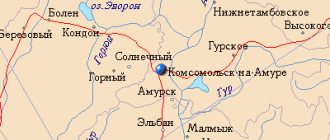
| 8 | Komsomolsk-on-Amur | 386 () | SW |
| 9 | Solar | 390 () | SW |
| 10 | Chumikan | 395 () | NW |
a brief description of
Located on the left bank of the Amur, 80 km from its confluence with the Amur Estuary, 583 km from the railway. Komsomolsk-on-Amur station, 977 km northeast of Khabarovsk. River and sea port.
Nikolaevsk-on-Amur is the industrial and cultural center of the Northern Amur region.
Territory (sq. km): 50
Information about the city of Nikolaevsk-on-Amur on the Russian Wikipedia site
Historical sketch
Founded in 1850 by the Russian navigator Admiral G.I. Nevelskoy as a military-administrative settlement (Nikolaevsky post, name in honor of Emperor Nicholas I (1796-1855)), which, thanks to its convenient geographical location, quickly acquired important economic and political significance on the Pacific coast. In 1855, the port was moved here from Petropavlovsk-Kamchatsky.
The city of Nikolaevsk since 1856. In 1858-1880. — regional center of the Primorsky region.
In 1872-73 the port was moved to Vladivostok.
At the end of the 19th century. Nikolaevsk is the center of the Uda district of the Primorsky region, there were 328 private houses, 40 state houses, 2 churches.
During the civil war, fierce battles took place on the territory of Nikolaevsk; in July 1920, it was burned by partisans, and subsequently rebuilt. In 1926 it was renamed Nikolaevsk-on-Amur. Until 1929 it was a district town, until 1934 it was the center of the Nikolaev district, in 1934 it was the center of the Lower Amur region.
Municipal indicators
| Index | 2001 |
| Demography | |
| Number of births, per 1000 population | 8.6 |
| Number of deaths, per 1000 population | 18.4 |
| Natural increase (decrease), per 1000 population | -9.8 |
| Standard of living of the population and social sphere | |
| Average monthly nominal accrued wages, rub. | 3421 |
| Average housing area per inhabitant (at the end of the year), sq.m. | 20 |
| Number of preschool institutions, pcs. | 8 |
| Number of children in preschool institutions, thousand people | 1.1 |
| Number of daytime educational institutions (at the beginning of the school year), pcs. | 11 |
| Number of students in daytime educational institutions, thousand people | 4.2 |
| Number of doctors, people. | 135 |
| Number of nursing staff, people. | 562 |
| Number of hospital institutions, pcs. | 5 |
| Number of hospital beds, thousand units | 0.6 |
| Number of medical outpatient clinics, pcs. | 7 |
| Capacity of medical outpatient clinics, visits per shift, thousand units. | 0.5 |
| Economy, industry | |
| Number of enterprises and organizations (at the end of the year), pcs. | 372 |
| Construction | |
| Volume of work performed by type of activity “Construction” (until 2004 - volume of work performed under construction contracts), million rubles. | 163.1 |
| Commissioning of residential buildings, thousand sq.m. of total area | 0.4 |
| Commissioning of residential buildings, apartments | 9 |
| Commissioning of preschool institutions, places | 0 |
| Commissioning of educational institutions, places | 0 |
| Commissioning of hospital facilities, beds | 0 |
| Commissioning of outpatient clinics, visits per shift | 0 |
| Transport | |
| Number of bus routes (in intracity traffic), pcs. | 4 |
| Number of passengers transported by buses per year (in intracity traffic), million people. | 3 |
| Connection | |
| Number of residential telephone sets of the city public telephone network, thousand units. | 5.3 |
| Trade and services to the population | |
| Retail trade turnover (in actual prices), million rubles. | 456.5 |
| Retail trade turnover (in actual prices), per capita, rub. | 15116 |
| Public catering turnover (in actual prices), million rubles. | 12.8 |
| Volume of paid services to the population (in actual prices), million rubles. | 216.7 |
| Volume of paid services to the population (in actual prices), per capita, rub. | 5569.9 |
| Volume of household services to the population (in actual prices), million rubles. | 10 |
| Volume of household services to the population (in actual prices), per capita, rub. | 256.1 |
| Investments | |
| Investments in fixed assets (in actual prices), million rubles. | 45.5 |
| Share of investments in fixed assets financed from budgetary funds in the total volume of investments, % | 27.9 |
Data sources:
- Regions of Russia. Main characteristics of the constituent entities of the Russian Federation: statistical collection. Goskomstat of Russia. - M:, 2003.
Economy
Leading industries: servicing the fishing industry and ship repair. Food industry enterprises (fish processing plant, sausage factory, etc.).
Potatoes, vegetables, and fodder crops are grown in the Nikolaev region. Poultry farming, meat and dairy cattle breeding.
Deposits of gold, brown coal, iron ore, alunites, zeolites, building materials.
Main enterprises
NON-FERROUS METALLURGY
LLC "Mnogovershinny"
682449, Khabarovsk Territory, Nikolaevsky district, town Mnogovershinny,
Offers:
Extraction of precious metals
SHIPBUILDING INDUSTRY
OJSC "Nikolaevsk-on-Amur Shipyard"
682430, Khabarovsk Territory, Nikolaevsky District, Nikolaevsk-on-Amur, st.
Sovetskaya, 126 Offers:
ship repair
AVIATION TRANSPORT
Nikolaevsk-on-Amur United Air Squadron
682430, Khabarovsk Territory, Nikolaevsky District, Nikolaevsk-on-Amur, Airport
Offers:
Culture, science, education
Museum of Local Lore.
At the Nikolaev Naval School in 1858-65. studied by Admiral S.O. Makarov. Travelers N.M. visited the city. Przhevalsky, V.K. Arsenyev; writers A.P. Chekhov, A.A. Faddeev. The creator of the first Russian aircraft, A.F., served in the city. Mozhaisky, polar explorer G.Ya. Sedov.
Obelisk (1915) and monument (1950) to G.I. Nevelsky.
Museums, galleries, exhibition halls
Intersettlement Museum of Local Lore named after. V.E. Rozova Nikolaevsky municipal district 682460, Khabarovsk region, Nikolaevsky district, Nikolaevsk-on-Amur, st. Sovetskaya, 71 Phone(s): (42135) 2-32-47
| Population by year (thousands of inhabitants) | |||||||
| 1897 | 5.7 | 1989 | 36.3 | 2006 | 26.6 | 2015 | 20.3 |
| 1926 | 7.5 | 1992 | 36.5 | 2007 | 26.0 | 2016 | 19.6 |
| 1931 | 12.0 | 1996 | 34.9 | 2008 | 25.4 | 2017 | 19.1 |
| 1939 | 17.3 | 1998 | 33.1 | 2010 | 24.5 | 2018 | 18.6 |
| 1959 | 30.9 | 2000 | 31.4 | 2011 | 22.8 | 2019 | 18.2 |
| 1967 | 32 | 2001 | 30.8 | 2012 | 21.9 | 2020 | 17.9 |
| 1970 | 30.1 | 2003 | 28.5 | 2013 | 21.4 | 2021 | 17.7 |
| 1979 | 33.5 | 2005 | 27.2 | 2014 | 20.8 | ||
Administrative and municipal status
Within the structure of administrative units, Nikolaevsk-on-Amur serves as the administrative center of Nikolaevsky District,[3] although it is not part of it.[1] As an administrative division, it is registered separately as a city of regional significance of Nikolaevsk-on-Amur
- an administrative unit with a status equal to that of a district.[1]
As a municipal entity, the city of regional significance Nikolaevsk-on-Amur is part of the Nikolaevsky municipal district as the Urban settlement of Nikolaevsk-on-Amur
.[5]
Nikolaevsk-on-Amur
(Khabarovsk region)
OKATO code:
08414
Founded:
1850
City since:
1856 City of district subordination (Nikolaevsky district, Khabarovsk Territory)
Center:
Nikolaevsky district
The city was formerly called:
| Nikolaevsky | 1850 | 1856 |
| Nikolaevsk | 1856 | 1926 |
| Telephone code (reference phone) | |
| 42135***** | 63-8-99 |
Deviation from Moscow time, hours:
7
Geographic latitude:
53°09′
Geographic longitude:
140°44′
Altitude above sea level, meters:
30 Sunrise and sunset times of the Sun and Moon in the city of Nikolaevsk-on-Amur
Climate
Nikolaevsk-on-Amur on the border of a humid continental climate (Köppen Dfb
), almost cold enough to be a subarctic climate (
DFC
). Precipitation in winter is not as low as in most of Siberia, since the coast is on the verge of the influence of the Aleutian Low. The coastal location softens winters only slightly—by 5 °C (9.0 °F) compared to inland Siberia, but makes summers noticeably cool (especially in May and June), although Oyashio fog is less common than on Sakhalin itself, and therefore the sun hours are much longer.
| Climate data for Nikolaevsk-on-Amur (1981–2010, extremes from 1881 to present) | |||||||||||||
| Month | Jan | Feb | Mar | Apr | May | Jun | Jul | Aug | Sep | October | But I | December | Year |
| Record high °C (°F) | 0.3 (32.5) | 5.7 (42.3) | 11.9 (53.4) | 19.6 (67.3) | 31.7 (89.1) | 34.3 (93.7) | 34.1 (93.4) | 35.3 (95.5) | 28.9 (84.0) | 22.5 (72.5) | 11.4 (52.5) | 2.8 (37.0) | 35.3 (95.5) |
| Average high °C (°F) | −17.5 (0.5) | −13.7 (7.3) | −5.6 (21.9) | 2.9 (37.2) | 10.5 (50.9) | 19.0 (66.2) | 21.7 (71.1) | 21.5 (70.7) | 16.2 (61.2) | 6.6 (43.9) | −6.1 (21.0) | −15.5 (4.1) | 3.3 (37.9) |
| Daily average °C (°F) | −21.8 (−7.2) | −19.0 (−2.2) | −11.6 (11.1) | −2.1 (28.2) | 5.0 (41.0) | 13.1 (55.6) | 16.5 (61.7) | 16.1 (61.0) | 10.6 (51.1) | 2.0 (35.6) | −10.3 (13.5) | −19.4 (−2.9) | −1.7 (28.9) |
| Average low °C (°F) | −25.6 (−14.1) | −23.4 (−10.1) | −16.9 (1.6) | −6.4 (20.5) | 0.9 (33.6) | 8.0 (46.4) | 12.2 (54.0) | 11.8 (53.2) | 6.3 (43.3) | −1.6 (29.1) | −14.0 (6.8) | −22.9 (−9.2) | −6.0 (21.2) |
| Record low °C (°F) | −47.2 (−53.0) | −45.9 (−50.6) | −37.6 (−35.7) | −28.8 (−19.8) | −11.9 (10.6) | −3.8 (25.2) | 1.3 (34.3) | 0.6 (33.1) | −6.0 (21.2) | −25.1 (−13.2) | −34.0 (−29.2) | −44.2 (−47.6) | −47.2 (−53.0) |
| Average precipitation mm (inches) | 42 (1.7) | 29 (1.1) | 33 (1.3) | 32 (1.3) | 53 (2.1) | 50 (2.0) | 60 (2.4) | 83 (3.3) | 82 (3.2) | 89 (3.5) | 60 (2.4) | 48 (1.9) | 660 (26.0) |
| Average rainy days | 0 | 0 | 0.5 | 5 | 15 | 14 | 15 | 18 | 19 | 15 | 2 | 0 | 104 |
| Average snow days | 17 | 17 | 18 | 16 | 9 | 0.1 | 0 | 0 | 0 | 12 | 21 | 19 | 129 |
| Average relative humidity (%) | 76 | 76 | 74 | 76 | 77 | 77 | 81 | 83 | 82 | 79 | 79 | 79 | 79 |
| Average monthly sunshine | 129 | 160 | 232 | 209 | 233 | 234 | 238 | 204 | 184 | 143 | 132 | 94 | 2,192 |
| Source 1: pogoda.ru.net[16] | |||||||||||||
| Source 2: NOAA (Sun 1961–1990)[17] | |||||||||||||
LiveInternetLiveInternet
VitaleGo
all posts by the author
District center The city of Nikolaevsk-on-Amur is a large seaport and industrial center of the Lower Amur region. General information Nikolaevsky district is located in the north-east of the Khabarovsk Territory, bordering on the Ulchsky district in the south, and the Tuguro-Chumikansky district in the west. In the north it is limited by the waters of the Sea of Okhotsk, in the northeast by the Sakhalin Gulf, in the east of the Amur Estuary and in the southeast of the Tatar Strait. The center of the district of Nikolaevsk-on-Amur is located at the mouth of the Amur River on its left bank. The city stands on a flat, calm plateau with a slight slope towards the Amur River, 21 meters above sea level. The date of foundation of Nikolaevsk-on-Amur is August 13 (August 1, old style) 1850. The Nikolaevsky district, as an administrative unit, had different names and was part of different territories over the years of its existence. The present name of the district “Nikolaevsky” was approved in 1965. The administrative border of the Nikolaevsky district was established by the decision of the Khabarovsk Regional Council of Workers' Deputies dated January 14, 1965 No. 20 “In pursuance of the Decree of the Presidium of the Supreme Council of the RSFSR dated January 12, 1965 No. 741 “On changes in the administrative-territorial division Khabarovsk Territory". The area of the city and district is 17188.3 sq. km. The territory of the city of Nikolaevsk-on-Amur is determined by city limits. The city limits were established by decision of the Khabarovsk Regional Executive Committee dated November 24, 1977 No. 689 on a total area of 37.24 sq. km. Brief history of the region On August 1, 1850, G.I. Nevelsky founded the first post on the Amur - Nikolaevsky. The number of its first inhabitants was 6 people. The first building was the Yakut hut-urasa. 1852 Nikolaevsky post was renamed into a trading post. 1854 Nikolaevsky post was a small village consisting of 5 residential buildings, a warehouse, a barnyard, and a chapel. A pier was built for arriving ships. On November 14, 1856, the Nikolaev post was transformed into the city of Nikolaevsk. The Primorsky region of the East Siberian General Government was formed with its center in Nikolaevsk. Nikolaevsk also became the main port of the Russian Far East. On February 24, 1858, Nikolaevsk was elevated to the status of a regional city. The number of buildings in the city increased to 200, the population - to 1,757 people. A mechanical plant for the assembly and repair of ships was built. A maritime school, a local history museum, and a library were opened. The first commercial voyages on the Amur River of private and state-owned ships began. Foreign merchant ships began to arrive in the city. 1860 In Nikolaevsk there were 706 buildings and houses, 10 shops, 2 hospitals, 4 educational institutions, incl. vocational school in the port. The population reached 5 thousand people. 1870 The main port of the Russian Far East was moved from Nikolaevsk to Vladivostok. On April 28, 1880, the center of the Primorsky region was moved from Nikolaevsk to Khabarovka. Nikolaevsk remained a district town. On July 3, 1884, Nikolaevsk became the center of the Uda district of the Primorsky region. 1891 Population dropped to 1,844. 1895 Population: 1000 people. Late 80s XIX century Discovery and beginning of development of gold placers. Nikolaevsk becomes the center of the gold mining industry of the Russian Far East. Here were the offices of the Amur-Orel and Okhotsk gold mining companies and a gold-alloying laboratory. 1896 The number of inhabitants increased to 2086 people. 1897 The number of inhabitants was 5668 people (in summer about 7 thousand people). 1896-1899 The fishing industry as a branch of the economy was formed in Nikolaevsk. A huge number of fishing and fish-salting areas were created in a short time. Shipbuilding has been revived in the city, enterprises have been created for ship repair, mechanical processing, timber processing, and production of barrel containers. Beginning of the 20th century The city of Nikolaevsk-on-Amur becomes the second river and sea port of the Russian Far East after Vladivostok. 1903 Uda district was replaced by Uda district. 1913 The population of Nikolaevsk increased to 14.4 thousand people. The number of buildings increased to 2136. The network of schools and vocational schools (including the school of mining technicians) developed again. On February 26, 1914, Nikolaevsk was elevated to the status of a regional city - the center of the Sakhalin region. The reconstruction of the seaport has begun. 1917 The city's population exceeded 15 thousand people. 1918 Beginning of the Japanese intervention. February 1920 The partisan army of Yakov Tryapitsyn entered the city. Late May - early June 1920 The city was burned by Tryapitsyn, the population was evacuated to Kerby. Japanese intervention. 1920-1922 The city of Nikolaevsk as part of the Far Eastern Republic is the center of the Sakhalin region. September 1922 Liberation of the city from Japanese intervention. Establishment of Soviet power. 1923 Nikolaevsk becomes the center of the Udsko-Kerbinsky district of the Primorsky province of the Far Eastern region. 1925 Nikolaevsk was declared open for the transit of goods from countries that have treaty relations with the USSR. Renaming the Udsko-Kerbinsky district to Nikolaevsky. March 15, 1926 The name of the city was approved according to the new territorial directory of the USSR - “Nikolaevsk-on-Amur”, it was declared the center of the Nikolaevsky district of the Primorsky province of the Far Eastern Territory. The area of the district is 558,096 sq. km. Districts - Nikolaevsky, Okhotsky, Tuguro-Chumikansky, Kerbinsky, Bolshe-Mikhailovsky, Nizhne-Tambovsky, Olsky, native subdistricts - Ulchsky, Amgunsko-Negidalsky, Amuro-Gilyatsky, Limano-Gilyatsky, Tuguro-Chumikansky Evenki, Okhotsk-Ayansky Evenki, Olsky Evenki 1932 Creation of the Nikolaev hydro airport. 1934 Nikolaevsk becomes the center of the newly created Lower Amur region. The area of the region is 518,279 sq. km. Districts - Nizhne-Amursky, Ulchsky, named after Polina Osipenko, Tuguro-Chumikansky, Okhotsky, Ayano-Maysky. 1936 Construction of the shipyard begins. ANT-25 aircraft with a crew of V.P. Chkalova, G.F. Baidukova, A.V. Belyakova made the world's first non-stop flight from Moscow to Udd Island. 1937 Construction of a ship repair plant begins. Creation of a regional drama theater with a troupe of 20 people. 1939 Nikolaev port was transformed into a sea port. 1942 Commissioning of the existing shipyard and ship repair plant. 1943 Nizhne-Amursky district was split into two districts - Nizhne-Amursky and Takhtinsky. 1946 Opening of the regional museum of local lore. 1948 Creation of an air detachment of the Far Eastern Directorate of the Civil Air Fleet on the basis of the Nikolaev airport. 1951 Opening of a sausage factory. 1954 Opening of a brick factory. 1956 Abolition of the Lower Amur Region. Nikolaevsk becomes the regional center of the Khabarovsk Territory (without creating a district). 1960 Opening of a shipbuilding plant on the basis of a shipyard and a ship repair plant. 1963 Formation of the Nikolaev united air squadron DVUGA. 1965 Formation of the Nikolaevsky district with the center in Nikolaevsk-on-Amur. 1973 Commissioning of the first stage of the Nikolaevskaya CHPP. 1984 Commissioning of the existing large-panel house-building plant "Mobil". 1985 Creation of the Nizhneamursky mining and processing plant. 1992 Secondary school No. 2 for 1,097 students was put into operation in the city. December 1994 The building of the Nikolaev-on-Amur branch of the Far Eastern Commercial Bank was put into operation. July 1996 The building of the Nikolaev branch No. 692 of Sberbank of the Russian Federation was put into operation 1998 The research vessel (NIS-4) was put into operation, the construction of which was carried out by Nikolaevsky-on-Amur Shipyard OJSC under a contract with the Japanese 1999 In the area, On the basis of the hospital in the village of Mago, a nursing home with 30 beds was created for pensioners, war and labor veterans. July 1999 The regular ferry crossing Nikolaevsk-Podgornoye was opened, which is part of the highway connecting Nikolaevsk-on-Amur with the regional center. August 1999 The state educational institution “Nikolaev-on-Amur Pedagogical School” was given the status of “school of indigenous peoples of the North” August 1999 Work at the Mnogovershinny mine was resumed July 2001 The Nikolaev-on-Amur Medical School was given the status of state educational establishment of a “school for indigenous minorities of the North” August 2001 A school for 72 students was put into operation in the village of Puir 2002 Construction of an Orthodox church was completed in Nikolaevsk-on-Amur. 2003 Mnogovershinnoye LLC reached its designed gold mining capacity and ranks 3rd among Russian mining and metallurgical plants. Historical and natural landscape attractions Obelisk to G.I. Nevelsky, the founder of the city of Nikolaevsk-on-Amur. City square. 1913 Opened in 1915 (author Ignatov P.S.). Monument-bust to O.K. Kanter, the first chairman of the Nizhneamur Regional Executive Committee. Kantera st. November 6, 1977. Sculptors: N.K. Geits, E.D. Molovinsky. Memorial complex "In memory of the fighters who died for the victory of Soviet power on the Lower Amur in 1918-1922." City square, September 25, 1972. Architect A.V. Mameshin. Sculptors: N.A. Geits, E.D. Molovinsky. Military-engineering and historical-revolutionary monument “Chnyrrakh Fortress” (Nicholas Fortress). village Krasnoe, 1855. Monument to G.I.Nevelsky, founder of the city of Nikolaevsk-on-Amur. Author A. Bobrovnikov. Opened on August 13, 1950. A memorial sign on the Petrovskaya Spit (Khaburs) on the site of the settlement of Petrovskoye Zimovye (Petrovsky Post), founded by the crew of the Baikal transport under the command of Captain G.I. Nevelsky. in 1849. Installed in 1971. The obelisk on Chkalov Island (Udd) in the Bay of Happiness in honor of the 50th anniversary of the landing in 1936 of the ANT-25 aircraft piloted by a crew under the command of V.P. Chkalov, which made a non-stop flight along the route Moscow - Udd Island. Opened in 1986. According to the decision of the regional authorities, on the territory of the Nikolaev region the following were created: the Priozerny hunting reserve of regional significance, the western part of Lake Orel, area 29.5 thousand hectares, organized for the purpose of preserving and restoring natural complexes, improving the protection and reproduction of wild animals and birds, preservation of their habitat, breeding conditions and migration routes. The natural monument of regional significance “The Bay of Happiness with the islands of Kevor and Chayachny” with an area of 263 square meters, protects the Aleutian tern, listed in the Red Book of the Russian Federation, as well as resting and feeding areas for migratory birds. A fishery reserve of local importance, the Ul River from the mouth to the mouth of the Malakhta River, the spawning grounds of salmon fish are protected. Specially protected natural areas of local importance: Vlasyevsky peat bogs, along the shore of the Sakhalin Gulf to the base of the Petrovskaya Spit, area 33.3 sq. km., protected forage lands, cranberry, lingonberry, cloudberry berries. Cape "Kamenny", south of Cape Litke along the coast, area 1.8 sq. km., protected seal rookery. Thermal (radon) spring with a water protection zone, Mnogovershinnoye forestry, with an area of 7.8 sq. km., the thermal spring is protected. Chastye Islands, 8 islands in the southern part of the Amur Estuary, with an area of 92 sq. km., bird colonies and pinniped rookeries are protected. The sea coast from Cape Litke to Cape Alexandra, with an area of 18 sq. km., is protected by the birthplaces of sea animals. The basin of the Medvezhiy stream, a fish hatchery, with an area of 12.5 sq. km., is protected by a unique stream and its basin. Reineke Island, with a one-kilometer marine calm zone, an area of 23 sq. km., is protected by the largest pinniped rookery in the Nikolaev region. Curtain of Manchurian ash, southern slope near the city of Nikolaevsk-on-Amur, Manchurian ash is protected. Famous people of the region Born in Nikolaevsk-on-Amur: Sergei Avmashulov (1894-1965) - American composer. Vladimir Doronin is a corresponding member of the Russian Academy of Sciences. Zhemaitis Sergei Georgievich - Soviet, Russian writer. Konchin Evgraf Vasilievich - journalist. Lyuri-Wizwell Ella Meyrovna is a philologist of Russian and French languages and literature, anthropologist. Honorary Professor at the University of Hawaii (USA), founder of the Russian program at the University of Hawaii, translator. Valery Sokhatov is a Moscow artist. Stepanova Angelina Osipovna (1905-2000) - Soviet actress, People's Artist of the USSR. Chaika Yuri Yakovlevich - Minister of Justice of the Russian Federation. Ilya Chernev is a Siberian writer. Ustinov Vladimir Vasilievich - Prosecutor General of the Russian Federation. Prominent figures of state, science and culture, whose names are associated with the history of Nikolaevsk-on-Amur and the region: Arsenyev Vladimir Klavdievich (1872-1930) - researcher of the Far East, ethnographer and writer. Explored the Sikhote-Alin mountains (1906-1910). Baidukov Georgy Filippovich (1907 - 1993) - Colonel General of Aviation. Hero of the Soviet Union. ANT-25 crew member (1936). Belyakov Alexander Vasilievich (1897 - 1982) - Lieutenant General of Aviation. Hero of the Soviet Union. ANT-25 crew member (1936). Boshnyak Nikolai Konstantinovich - Traveler and researcher. Companion of G.I.Nevelsky. Researcher of the Amur Estuary, Sakhalin Island and the coast of the Tatar Strait. Girev Dmitry Semenovich (1889-1932) - participant in R. Scott’s expedition to the South Pole in 1911-1912. Davydova Vera Aleksandrovna - Soviet singer, People's Artist of the RSFSR (1951) and the Georgian SSR (1981), laureate of the USSR State Prize (1946, 1950, 1951). Makarov Stepan Osipovich (1848/49-1904) - Russian naval commander and inventor. Admiral. In his childhood and youth he lived and studied in Nikolaevsk-on-Amur. Mozhaisky Alexander Fedorovich (1825-1890) - Russian inventor. Rear Admiral. He served in the Chnyrrakh (Nikolaev) fortress. Muravyov Nikolai Nikolaevich, Count of Amur (1809-1881) - Governor-General of the Primorsky Region. The leader of the first rafting along the Amur River (1854), Gennady Ivanovich Nevelskoy (1813-1876), was a Russian traveler and researcher. Admiral. Discoverer of the strait between Sakhalin Island and the mainland. Founder of Nikolaevsk-on-Amur (1850) and Petrovsky post (1849). Okladnikov Alexey Pavlovich (1908-1981) - Soviet archaeologist and historian. Author of works on archeology and ethnography of the Lower Amur. Hero of socialist labor. Przhevalsky Nikolai Mikhailovich (1839-1888) - Russian traveler and explorer. Sedov Georgy Yakovlevich (1877-1914) - Russian hydrographer, polar explorer. He served in the Chnyrrakh (Nikolaev) fortress at the beginning of the 20th century. Explored the Amur Estuary. Chkalov Valery Pavlovich (1904-1938) - Soviet test pilot. The commander of the crew of the ANT-25 aircraft that made the world's first long-term non-stop flight on the route Moscow-Udd Island. Fabricius Jan Fritsevich - Hero of the Civil War. Geographical data The geographical location of the area is determined by the coordinates of 138 degrees 40 seconds and 141 degrees 30 seconds east longitude and 51 degrees 31 seconds, 54 degrees 20 seconds north latitude. Its territory within its modern borders is 17,188.3 square kilometers. The center of the region - Nikolaevsk-on-Amur - is located on the left bank of the Amur River near its mouth. It is located at a distance of 582 kilometers northeast of Komsomolsk-on-Amur and 977 kilometers northeast of Khabarovsk. Other settlements are located along the Amur River (the villages of Innokentyevka, Sakharovka, Konstantinovka, Podgornoye, Krasnoye, Oremif, the village of Mago, the village of Chnyrrakh), near lakes (the villages of Chlya and Orel-Chlya), on the coast of the Sakhalin Gulf, the Amur Estuary (the villages of Puir, Ozerpakh and Lazarev), as well as at the developed deposits (mines) - the village of Mnogovershinny. The municipality includes 27 settlements: 1 city, 3 workers' settlements, 4 towns and 19 villages. There are also several lighthouses, weather stations, hunters' bases and seasonal fisheries in the area. Climate The territory of Nikolaevsk-on-Amur and the Nikolaevsky district belongs to a moderately cold, humid climate. The region's climate is formed under the influence of the Sea of Okhotsk. The duration of the period with temperatures above + 10 degrees is 90-135 days. The greatest amount of precipitation falls in the second half of summer, when the strong influence of the summer monsoon is felt. The average annual precipitation is 513 millimeters. The intensity of precipitation causes 6-8 floods on the rivers. Winter is long and frosty. Stable snow cover is established in the third ten days of October and lasts 165-200 days. The average height of snow cover reaches 30 cm, and in the lower reaches of the Amur - 60-90 centimeters. The average temperature in January is minus 25.6 degrees, the average annual temperature is minus 2.3 degrees. Transport Communication with the regional center: air and water transport. The main transport artery of the region is the Amur River. During the navigation period, passenger transportation is carried out by Meteor-type vessels owned by Amur Shipping Company OJSC and Amur Port OJSC (Komsomolsk-on-Amur). Intercity transportation is carried out daily during the navigation period on the lines: Khabarovsk - Nikolaevsk-on-Amur - Khabarovsk and Komsomolsk-on-Amur - Nikolaevsk-on-Amur - Komsomolsk-on-Amur. On suburban lines and lines for servicing dacha cooperatives, the motor ships "OM - 5" and "Opal" of the Nikolaevsk-on-Amur fleet department of Amur Shipping Company OJSC are used: Nikolaevsk-on-Amur - Podgornoye - Nikolaevsk-on-Amur; Nikolaevsk-on-Amur – Denisovka – Nikolaevsk-on-Amur; Nikolaevsk-on-Amur – Murdered – Nikolaevsk-on-Amur. Aviation in the region’s economy asses an extremely important role. This is due to the absence of a railway and the absence of road roads of year -round, seasonal work of sea and river transport. The main carrier is KSGU Khabarovsk Airlines. The basic airport is located in Nicolaevsk-on-Amur, in addition, a number of airports of the northern regions of the Khabarovsk Territory are included in the structure of the air detachment. Greek passenger air transportation is carried out on the following lines: Nikolaevsk-on-Amur-Khabarovsk-Nikolaevsk-on-Amur on Yak-40 aircraft (2 flights per day); Nikolaevsk-on-Amur-Okhotsk-Nikolaevsk-on-Amur-Khabarovsk-Nikolaevsk-on-Amur on Yak-40 aircraft (2 times a week); Nikolaevsk-on-Amur-named after Osipenko-Nikolaevsk-on-Amur on An-2 aircraft (once a week); Nikolaevsk-on-Amur-Udsk-Nikolaevsk-on-Amur on Mi-8 helicopters (2 times a month); Nikolaevsk-on-Amur-Lazarev-Nikolaevsk-on-Amur on An-2 aircraft (once a week). In addition, at the request of administrations of the settlements of the districts, the Intersason flights of the Mi-2 and Mi-8 helicopters are operated. The length of the roads of the Nikolaev district is 209.8 km, including with an improved coating of 156.8 km. Currently, in the district, the construction of a part of the Selikhino-Nikolaevsk-on-Amur highway is underway (the total length of which is 518 km). Passenger road transport in the city and the district is performed by Nikolaevskoye-on-Amur Municipal Auto Transport Enterprise. The following bus passenger transportation is carried out: the intercity route Nikolaevsk-on-Amur-multi-versed-Nikolaevsk-on-Amur (3 times a week); suburban routes: Nikolaevsk-on-Amur-Mago-Nikolaevsk-on-Amur (2 times a day); Nikolaevsk-on-Amur-Lakes-Nikolaevsk-on-Amur (2 times a day); Nikolaevsk-on-Amur-Chnyrrah-Nikolaevsk-on-Amur (10 times a day). city routes (5 routes); Country routes (annually from May 1 to October 31): the city - 11 km of the Maginsky road; The city is the cottage of the shipbuilding plant. For the period of the school year, a route for the transportation of schoolchildren is used in the village of Krasnoye. Passenger transportation by passenger vehicles are engaged in individual entrepreneurs Lustina O.L. ("Radio-Taxi"), Ledukhovsky V.L. ("Taxi-Turs"). The symbolism of the city and the district municipality "The city of Nikolaevsk-on-Amur and the Nikolaev district" has a coat of arms and flag. Heraldic description of the coat of arms: “In the lapel (blue, blue) field above the silver wavy ending - two diverging green mountain slope, thinly bordered by silver and between them flying to the right of a black eagle with sifted wings, having brown (red) eyes, golden beaks and pressed paws , silver shoulders and tail; in a low -lowering shield in a caress field on a wavy silver tip, burdened with a lapel fish, a golden wall with two round towers and open gates, accompanied at the top with two gold pickles, pointed from two ends with arms upwards upwards; On top of Kirik - a shovel with a hilt down the same metal. ” The description of the coat of arms says the following: “The main figure of the coat of arms is the heraldic eagle - a symbol of the height of the spirit, allegorically shows the rare bird Orlan, whose habitat is the mouth of the Amur and the Okhotsk coast. At the same time, the eagle symbolizes courage, faith, victory, greatness and power, and its direction of flight and open wings - the desire forward, into the future, the ability of a person to overcome difficulties. His brutal eyes denote courage and courage, and the golden beak means strength, health, supremacy and greatness. The black color in Heraldic has a deep meaning, it is a symbol of prudence, wisdom, eternity. The mountain slopes reflect the natural-climatic features of the region and allegorically show Cape Prong and Cape Tabakh, and the golden wall between them allegorically shows the entrance to the Amur. Green is a symbol of hope, abundance, update of life. The silver ends in the shield and the main field symbolizes the waters of the Amur estuary and the Sea of Okhotsk. Silver in the heraldry is a symbol of purity, wisdom, nobility, peace, mutual labor. The combination of a shovel is the emblem of construction and creation with the picks - the emblem of the mining and stunned industry, symbolizes the mining industry (mining), and gold mining, from which the development of the city and the region began. Gold in heraldry is a symbol of strength, wealth, greatness, intelligence and insight. The fish shows the natural wealth of coastal waters, the leading industry of the area of the region - fishing and processing of seafood. The azure in the heraldry is the color of the clear sky, symbolizes constancy and devotion, justice and perfection, honor and virtue. ” The flag of the city and district (Figure 2) is a rectangular panel, divided into 3 horizontal equal stripes: upper blue, middle green, lower - white color and red strip, horizontally passing through the center of the panel, the width of which is 1/5 of the width of one of the stripes . The panel of the flag of the city and the district is made using three heraldic and the colors of one noble metal, which mean: blue (azure) - a symbol of constancy and devotion, justice and perfection, honor and virtue. In this case, the clear blue sky symbolizes; Green (greens) - the color of hope, joy, abundance. Symbolizes the unique flora and fauna of our region, "the endless sea of the taiga"; White (silver) is a symbol of purity, wisdom, nobility, peace, mutual activity. In the flag palette, he reflects the silver waters of the Amur; Red is a symbol of courage and courage. In this case, the tragic, courageous, contradictory and turning point in the history of Nicolaevsk-on-Amur year symbolizes. Nature. The natural resources of the Nikolaev district are located in the coniferous-chirocolide forest zone. The total area of the forest fund lands is 1692.7 thousand hectares, including forest covered with forests of 1291.7 thousand hectares. The total supply of wood is estimated at 174.5 million cubic meters. or about 3 percent of the marginal reserves. The estimated forest section is 985 thousand cubic meters, including an affordable 669 thousand meters. Forest vegetation is represented by fir, deciduous, coniferous-crumpled forests. Light-and-bored forests spread through the more gentle slopes of the mountains. The animal world is distinguished by a variety and wealth. In the forests there is a moose, Okhotsk northern deer. From other animals with commercial significance, sable, ermine, columns, protein, white-white, fox red, mink, otter, and ondatra live. There are lynx, wolverine, brown bear. Of the constantly inhabiting birds in the forests, a hazel grouse, a capercaillie, a white partridge, white -fingered Orlan are found. Blueberries, lingonberries, mountain ash, mushrooms, paporotnik-orlyak grow in the district. The strongest fires held in 1998 on huge forests significantly undermined the forest resources of the district. The resources of hunting animals are assigned: for the collective hunting company "Nikolaevsky" on an area of 1195.5 thousand hectares and the district society of hunters and fishermen "Nikolaevskoye" - 132.5 thousand hectares. On the territory of the district, mineral deposits of minerals, which are of important national economic significance, among which the leading place belongs to gold are open and explored. In the region, 44 deposits of placer are taken into account, the reserves of which are 12.5 tons. There are two main deposits of ore gold in the region: multi -versed and white mountain. Of the metal minerals in the area, a small manifestation of molybdenum, iron (brown iron) with forecast resources of about 350 thousand tons was revealed. In the region, two manifestations of Alunity-Ukhtomskoye and Katerkin are known, whose resources are estimated at 4.4 million tons. In addition, a small deposit of Morion and Amethyst with resource reserves of 2.6t is known suitable for driving processing and a promising porcelain stone deposit. There are large and rich zeolites in the district. An example is the gray -haired field, the resources of which are estimated at 83.6 million tons, located 7 km. north of the village of Innokentyevka on the left bank of the Amur. On the area of the deposit, the thicknesses of the acidic composition of the acidic composition, converted into zeolite ores from the poor (15-20 percent of zeolites) to very rich (more than 80 percent of zeolites) are common. The power of zeolitized tuffs reaches 300 meters. The forecast resources of zeolite ores are estimated at 100 million tons. The Porcelain stone deposit of the White Mountain is located 14 km north of Lake Chl. The reserves of the deposit are about 15 million cube. meters. The studied breeds meet the requirements of the porcelain industry, in quality are close to the porcelain stone of the Gusevsky deposit in the Primorsky Territory. Within the Ust-Amurskaya Bloodfine in the Nala River Valley, the Nalevskoy Baro-Ugon Field was long known, explored back in 1931. Within the territory of the Nikolaev district, there are promising for the search for oil and gas Kizi-Lazarevskaya and Chli Orelsky hollows. On the territory of Kizi-Lazarevskaya Square, the current oil and gas pipeline Okha-Komsomolsk-on-Amur has been laid, which determines the exceptionally favorable economic conditions for the development of this area with positive geological results in the search for oil and gas. In structural terms, Kizi-Lazarevskaya Square is located on the western flank of the Tatar deflection with established oil and gas. The assessment of the forecasting resources of the hydrocarbon area is 140-200 million tons, including the extracted 50-60 million tons. conditioned fuel. More significant forecast resources correspond to the shelf zone of the Tatar Strait and the Amur Gulf, which are estimated at 500-600 million tons. conditioned fuel. The priority task of mastering these promising areas is the organization of oilopoisian geological and geophysical studies, since the knowledge of the area is extremely low. Due to the natural-climatic features, all the swamp masses of the Nikolaev district have a powerful (6-8m) peat deposit, in the addition of which the poorly decorated residues of sphagnum mosses mainly participate. Sapropel, accumulated in the lakes of the Amur Region, is a mixture of dead algae (mainly diatomic), remains of water animals and minerals, which enters the lakes with the river stock in them. The main reserves of the Sapropel of the Nikolaev district are concentrated in the lakes of Orl and Chl. In small quantities, Sapropel is also found in other lakes. Warm waters (25-31 degrees C) of the Ulch thermal source, which is in the valley of the stream-right tributary of the Pavlinka River, 6 km from the village of Military. Thermal water is alkaline, bicarbonate-sulfate, sodium, weakly minorized. The detailed searches of the Ulchi detachment, carried out in 1986-1987, revealed the contour of the site promising for the production of drilling and experimental and filtration work, but in the conditions of remoteness and unassvustment of the territory, further continuation of the search and reconnaissance work is problematic. The economic specialization of the district is largely determined by the water-biological resources of the Amur River, its estuary, the Sakhalin Bay and the Tatar Strait. The main reservoirs of the reproduction of large partial fish (carp, pike, catfish, top) in the area are the pools of lakes Orel and Chl. The Sig Ussuriysky and Khadars in large quantities live in the mouth of the Amur and the Amur Liman. The end and estuary of the Amur is currently the main area of the sturgeon Nagul, since the horse populations, in particular, Kaluga, riding the Amur in line. There are practically no sturgeons in the waters of the Nikolaev district. The number of sturgeons in recent years has been catastrophically reduced, first of all, due to poaching, activated after 1992. The wrappers in the Amur basin are great - the annual catch can reach 2000 tons per year. A lamprer is a predator in relation to the young car in the coil of the Amur salmon. More than 90 percent of the young people of the Amur salmon are departed by the young lamprey in the early sea period of life (in the estuary and the sea coast). The development of large -scale fishing lapels and the reduction of its number in the Amur is one of the current measures to restore the number of Amur salmon. The area of the mouth of the Amur has a huge potential of salmon fishing. In addition to Keta and Gorbushi, on which industrial fishing is traditionally based, the area has the reserves of other salmon, which, due to insufficient research and small number, are not included in the list of recommended Tinro-center for catching. This is about 10 tons, Malma in the rivers of Liman and the Sakhalin Bay of no more than 10 tons. In the last 50 years, the conditions for the reproduction of the summer chum in the Amur are not favorable. Currently, the reserves of the summer chumes are small and its common catch does not even reach the Rybnovsky district of the Sakhalin Region 3 thousand per year. The Nikolaevsky district accounts for about 20 percent of the natural reproduction of the summer chuck in the Amur Basin (Lake Orel and Lake Member). The commercial catches of the Amur Autumn Keta have not exceeded 5 thousand tons for more than 20 years, which is a consequence of the depression of the number of the herd, one of the main causes of which is poaching. The estimate of the pink salmon of the Nikolaev region in the natural reproduction of the Amur is about 40 percent. The Nikolaev district has a reserve that can compensate for the decrease in the catching quotas of salmon in the Amur. This is, firstly, the River of the Sakhalin Bay: Tyvina, Kohl, claims. The total catch of salmon here is largely dependent on the number of keta, unfortunately in recent years, its reserves in Tyvlin's rivers and the claims have been greatly undermined by poaching. Objects of small-scale coastal fishing: fishing forms of flounder (star and dark), de-Kastinskaya herring, Navaga, Loban (Pilengas), Japanese corbicula, blue crab, shrimp, seaweed, marine mammals: seals, Lachatt, Akiba, Larga) , Beluha. The sectors of the economy are the main sectors of the economy of the city and the district: the production of non -ferrous metals; shipbuilding and ship repair; construction; energy; harvesting and processing of wood; Pisces mining and processing. The population and nationality of the national composition is represented by more than 21 nationality. Most residents are Russians. Among other most numerous groups are Ukrainians, Tatars, Belarusians, Mordovians, Chuvash, Nanai, Nivkhi, Ulchi. Among age groups, a mature, able -bodied population prevails. Most of the inhabitants of working age are employed in the field of industry. The population of the district as of 01.01.2004 was 41.4 thousand people, including the city of 27.7 thousand people, workers' villages 7.1 thousand, villages of 6.6 thousand people. Of the indigenous and small peoples of the north, Nanai, Evenki dominate, in addition, Chukchi, Nenets, Mansi, Aleutians, Negidians, Udigans, Ulchi live in the area. International ties, tourism since 1996, in the Nikolaev district, systematic work has been carried out: joint Russian-Japanese archaeological and ethnographic expeditions, Japanese and Korean television companies are shot films about the history of the development of lower cupid and the life of local peoples. Nikolaevsky-on-Amur Municipal Museum of Local Lore named after Rozov, thanks to its unique collections and research work, becomes the center of international research. The museum has established scientific ties with the University of Tsukuba (Tokyo, Japan) and the National Ethnographic Museum (Osaka, Japan), preliminary invitations were received for the Association of Museums of the Northern Territories (S. Hokkaido) and participation in the International Ethnographic Exhibition in 2001 (Osaka) . The main settlements of the district of Nicolaevsk-on-Amur, R.P. Lazarev, R.P. Mago, R.P. MnoVereshinin, P. Punge, P. Ozerpakh, P. Puir, village of Chnyrry.
View of the village Mnogovershinny
view of the Mago village
source: https://www.khabkrai.ru/about/nikolaevsky.html photos: https://www.nikoladm.ru/Glav042.htm place on the map: HERE
Gallery
- Seaport Administration
- The air port was built in 2015
- The airport was built in 2015
- Mass grave of 3 16th Army officers killed in the line of duty, with headstone
- View from the square
- Town Square
- Postal building built in 1905
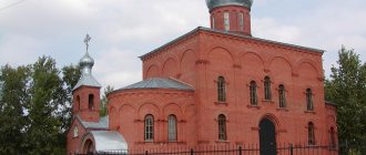
- Stone Temple
- Cinema Modern is now a museum named after. V.E. Rozova.
- Cinema "Rodina
- The Sailors' Club is now a grocery store.
- Nikolaevsk-on-Amur Lighthouse
- View of Nikolaevsk-on-Amur from the ski resort
- Nikolaevsk-on-Amur night view of Lunacharsky street
- Monument to G.I. Nevelsky on the embankment
- Monument to the 7th crew of the Naval School
- Nonstop Flight Monument
Far Eastern Khatyn
The years of the Civil War and intervention brought the city into a state of complete economic ruin, hunger, and poverty. In 1918, Japanese intervention began. At the beginning of December 1919, a partisan detachment under the command of 23-year-old Yakov Tryapitsyn descended along the Amur to Nikolaevsk. Among the members of the detachment there were many former criminals who had escaped from the Sakhalin penal servitude and were engaged in robberies in the taiga.
It was their detachment that Nikolaevsk was burned to the ground, and its population exterminated or expelled. But the city rose from the ashes and was rebuilt.
The regimental priest Rafail Voetsky suffered martyrdom at the hands of Tryapitsyn’s gang. According to eyewitnesses, he behaved with extraordinary dignity, which amazed even his tormentors.
The Red Army soldiers themselves claimed that “during his torment they could not get a scream or a groan, and only when he lost consciousness did they break out of him. When his suffering reached its highest degree, he asked for a drink, which, as the Red Army soldiers said, was not denied to him” (from the book of eyewitness Konstantin Aleksandrovich Emelyanov “People in Hell”).
They said about Father Rafail that “he gave his last parting words to his cellmates, but he himself prayed for all his tormentors. The personality and behavior of Priest Voetsky made a great impression even on the Chinese partisans. They told many of the residents of Nikolaevsk that at the time of his death his head was surrounded by radiance.”
Another Amur priest, Philip Raspopov, who, when he was a deacon, served in St. Nicholas Cathedral in Nikolaevsk, suffered from the same gang. He accepted martyrdom for Christ in December 1919 in the village of Troitskoye. Anarchist partisans broke into the house of Philip's father, where he lived with his wife and seven small children, dragged him naked into the street and dragged him to the Amur River. On the shore he was insulted and beaten for a long time, and then thrown into an ice hole. Father Philip was canonized by the Russian Orthodox Church Outside of Russia.
The persecution of the Church was not in vain: from the thirties until the middle of the Great Patriotic War, not a single functioning church and not a single registered clergyman remained in the entire region. For a long time, religious services were performed by believers in secret. And only in 1993, under Bishop Innocent (Vasiliev) of Khabarovsk and Blagoveshchensk, the building of the former regional radio committee and evening school No. 1 was transferred to the St. Nicholas parish of the city of Nikolaevsk. And in August 1998, already under Bishop Mark (Tuzhikov) of Khabarovsk and Amur, a new church was founded in the name of St. Nicholas. It was erected in the area of the cultural park, near the place where the cemetery church had previously been located.
By the way, St. Nicholas Church is the only stone temple in the entire north of the Khabarovsk Territory. It is also symbolic that the temple is crowned by Lenin Street, the other end of which abuts the Nevelsky monument. This is how, through the exploits, heroism and holiness of some and the cruelty and recklessness of others, this distant Far Eastern city grew, fell and rose again, the history of which I want to share with everyone...
References
Notes
- ^ a b c d e
Resolution No. 143-pr, Article 3 - ^ a b c
Federal State Statistics Service of Russia (2011).
“All-Russian Population Census 2010. Volume 1" [All-Russian Population Census 2010, vol. 1]. All-Russian Population Census 2010 [All-Russian Population Census 2010]
(in Russian). Federal State Statistics Service. - ^ a b
State Committee of the Russian Federation on Statistics.
Committee of the Russian Federation for Standardization, Metrology and Certification. No. OK 019-95 January 1, 1997 “All-Russian classifier of objects of administrative-territorial division. Code 08 414”, Ed. changes No. 278 / 2015 dated January 1, 2016. (State Committee of the Russian Federation on Statistics. Committee of the Russian Federation on Standardization, Metrology and Certification. No. OK 019-95 January 1, 1997 Russian Classification of Administrative Objects (OKATO). Code 08 414
As amended by Amendment No. 278/2015 dated January 1, 2016). - State Committee of the Russian Federation on Statistics. Committee of the Russian Federation for Standardization, Metrology and Certification. No. OK 019-95 January 1, 1997 “All-Russian classifier of objects of administrative-territorial division. Code 08 231”, Ed. changes No. 278 / 2015 dated January 1, 2016. (State Committee of the Russian Federation on Statistics. Committee of the Russian Federation on Standardization, Metrology and Certification. No. OK 019-95 January 1, 1997 Russian Classification of Administrative Objects (OKATO). Code 08 231
As amended by Amendment No. 278/2015 dated January 1, 2016). - ^ a b c
Law No. 191 - Law No. 264
- "On the calculation of time." Official Internet portal of legal information
(in Russian). June 3, 2011. Retrieved January 19, 2022. - Post office. Information and computing center of OASU RPO. ( Post office
).
Search for postal facilities ( Search for postal facilities
) (in Russian) - Federal State Statistics Service of Russia (May 21, 2004). “The population of Russia, the constituent entities of the Russian Federation as part of federal districts, urban settlements, urban settlements, settlements, settlements is 3 thousand or more people” [Population of Russia, its federal districts, constituent entities of the federation, districts, urban settlements, rural settlements - administrative centers, rural settlements with a population of more than 3000 people] (XLS). All-Russian Population Census of 2002 [All-Russian Population Census of 2002]
(in Russian). - ^ a b
“All-Union Population Census of 1989. The actual population of the union and autonomous republics, autonomous regions and districts, territories, regions, urban settlements and villages-raiTyr steles and the Yong Ning temple in the light of Chinese-Jurchen relations of the XIV-XV centuries ."
Archived February 23, 2009. Wayback Machine (Tire Steles and Yongning Temple Seen as Aspect of Sino-Jurchen Relations), Ethno-Journal
, November 14, 2008. - Tourism objects - Archaeological. Tyr Temples Archived September 3, 2009 Wayback Machine (Regional government website explaining the location of the Tyr (Telin) temples: south of the village of Tyr)
- [1]
- Sorinka, Victor L. (1998). Siberia: Worlds Apart
.
Westview series about post-Soviet republics. 5
. Westview Press. paragraph 46. ISBN 9780813312989. Retrieved June 20, 2015. When they unfurled the Russian flag at the mouth of the Amur and christened the place Nikolaevsky in honor of the Tsar, Nevelskoy and Muravyov caused a storm of protest […] - “Nikolaevsky-ITL on the Memorial website (German).” Archived from the original on September 27, 2007. Retrieved January 5, 2009.
- "Climate of Nikolaevsk-on-Amur." Weather and climate. Archived from the original on December 3, 2022. Retrieved December 3, 2022.
- “Climate norms of Nikolaevsk-on-Amur 1961–1990.” National Oceanic and Atmospheric Administration. Retrieved December 3, 2022.
Sources
- Government of the Khabarovsk Territory. Resolution No. 143-pr of July 18, 2007 “On approval of the register of administrative-territorial and territorial units of the Khabarovsk Territory,” as amended. Resolution No. 273-pr dated August 28, 2015 “On amendments to the Resolution of the Government of the Khabarovsk Territory dated July 18, 2007 No. 143-pr “On approval of the register of administrative-territorial and territorial units of the Khabarovsk Territory””. Entered into force on August 13, 2007. Published: “Collection of Legislation of the Khabarovsk Territory”, No. 7 (60), August 12, 2007 (Resolution of the Government of the Khabarovsk Territory of July 18, 2007 No. 143-pr. On approval of the Register of administrative-territorial formations and territorial units of the Khabarovsk Territory
As amended by the resolution dated August 28, 2015 No. 273-pr.
On amendments to the resolution of the Government of the Khabarovsk Territory dated July 18, 2007 No. 143-pr “On approval of the Register of administrative-territorial and territorial units of the Khabarovsk Territory.”
. Effective from August 13, 2007). - Legislative Duma of the Khabarovsk Territory. Law No. 191 of June 30, 2004 “On granting administrative centers the status of urban and rural settlements and on establishing their boundaries,” as amended. Law No. 172 of February 29, 2012 “On the abolition of the rural settlement of Festivalny, located on the territory of the Solnechny Khabarovsk Territory, and amendments to certain Laws of the Khabarovsk Territory.” Came into force on the date of official publication. Published: “Priamurskie Gazette”, No. 126–127, July 15, 2004 (Legislative Duma of the Khabarovsk Territory. Law No. 191 of June 30, 2004. On giving the administrative centers of districts the status of urban and rural settlements and establishing their boundaries
As amended by the Law dated February 29, 2012 No. 172.
On the abolition of the rural area of the Festivalny village in the Solnechny district of the Khabarovsk Territory and on amendments to various laws of the Khabarovsk Territory
... Valid from the date of official publication.). - Legislative Duma of the Khabarovsk Territory. Law No. 264 of March 14, 2005 “On administrative centers of rural settlements and municipal communications of the Khabarovsk Territory,” as amended. Law No. 239 of November 28, 2012 “On the transformation of the urban settlement of the working village of Tyrma, located on the territory of the Verkhnebureinsky district of the Khabarovsk Territory, by changing its status into a rural settlement - the village of Tyrma and introducing amendments to certain Laws of the Khabarovsk Territory.” Came into force on the date of official publication. Published: “Priamurskie Vedomosti”, No. 57, April 1, 2005 (Legislative Duma of the Khabarovsk Territory. Law No. 264 of March 14, 2005 On administrative centers of rural settlements and municipal districts of the Khabarovsk Territory
As amended by Law No. 239 of November 28, 2012 On
the transformation of the urban settlement of Tyrma, located on the territory of the Verkhnebureinsky district of the Khabarovsk Territory, by changing its status to a rural settlement - the village of Tyrma, and on amendments to various laws of the Khabarovsk Territory
. Valid from the date of official publication.).
Links[edit]
Notes[edit]
- ^ abcde Resolution No. 143-pr, article 3
- ^ abc Federal State Statistics Service (2011). “All-Russian Population Census 2010. Volume 1" [All-Russian Population Census 2010, vol. 1]. All-Russian Population Census 2010 [All-Russian Population Census 2010]
. Federal State Statistics Service. - ^ ab State Committee of the Russian Federation on Statistics. Committee of the Russian Federation for Standardization, Metrology and Certification. No. OK 019-95 January 1, 1997 “All-Russian classifier of objects of administrative-territorial division. Code 08 414”, ed. changes No. 278 / 2015 dated January 1, 2016. (Goskomstat of the Russian Federation. Committee of the Russian Federation for Standardization, Metrology and Certification. No. OK 019-95 January 1, 1997. Russian classification of administrative divisions) (OKATO).
Code 08 414 , as amended by Amendment No. 278/2015 of 01/01/2016). - State Committee of the Russian Federation on Statistics. Committee of the Russian Federation for Standardization, Metrology and Certification. No. OK 019-95 January 1, 1997 “All-Russian classifier of objects of administrative-territorial division. Code 08 231”, ed. changes No. 278 / 2015 dated January 1, 2016. (Goskomstat of the Russian Federation. Committee of the Russian Federation for Standardization, Metrology and Certification. No. OK 019-95 January 1, 1997. Russian classification of administrative divisions) (OKATO).
Code 08 231 , as amended by Amendment No. 278/2015 of January 1, 2016). - ^ abc Law No. 191
- Law No. 264
- "On the Calculation of Time". Official Internet portal of legal information
. June 3, 2011. Retrieved January 19, 2022. - Post office. Information and computing center of OASU RPO. ( Post office
).
Search for postal service objects ( postal Search for objects
) (in Russian) - ↑
Federal State Statistics Service of Russia (May 21, 2004).
“The population of Russia, the constituent entities of the Russian Federation as part of federal districts, urban settlements, settlements, settlements of 3 thousand or more people” [Population of Russia, its federal districts, federal districts, districts, urban settlements, rural settlements - administrative centers and rural settlements with a population of more than 3,000 people] (XLS). All-Russian Population Census of 2002 [All-Russian Population Census of 2002]
. - ^ ab "All-Union Population Census 1989. Population of union and autonomous republics, autonomous regions and districts, territories, regions, urban settlements and villages-district Nikolaevsky-ITL on the Memorial website (German)". Archived from the original on September 27, 2007. Retrieved January 5, 2009.
- "Climate of Nikolaevsk-on-Amur". Weather and climate. Archived from the original on December 3, 2022. Retrieved December 3, 2022.
- "Climate norms of Nikolaevsk-on-Amur 1961–1990". National Oceanic and Atmospheric Administration. Retrieved December 3, 2022.
Sources [edit]
- Government of the Khabarovsk Territory. Resolution No. 143-pr of July 18, 2007 “On approval of the register of administrative-territorial and territorial units of the Khabarovsk Territory,” as amended. Resolution No. 273-pr dated August 28, 2015 “On amendments to the Resolution of the Government of the Khabarovsk Territory dated July 18, 2007 No. 143-pr “On approval of the register of administrative-territorial and territorial units of the Khabarovsk Territory””. Entered into force on August 13, 2007. Published: “Collection of Legislation of the Khabarovsk Territory”, No. 7 (60), August 12, 2007 (Government of the Khabarovsk Territory. Resolution No. 143-pr dated July 18, 2007 “ On approval of the Register of administrative territorial formations and territorial units of the Khabarovsk Territory"
as amended by Resolution No. 273-pr dated August 28, 2015.
On amendments to the Decree of the Government of the Khabarovsk Territory dated July 18, 2007 No. 143-pr "On approval of the Register of administrative-territorial units and territorial units of Khabarovsk edge"
. Valid since August 13, 2007). - Legislative Duma of the Khabarovsk Territory. Law No. 191 of June 30, 2004 “On granting administrative centers the status of urban and rural settlements and on establishing their boundaries,” as amended. Law No. 172 of February 29, 2012 “On the abolition of the rural settlement of Festivalny, located on the territory of the Solnechny Khabarovsk Territory, and amendments to certain Laws of the Khabarovsk Territory.” Came into force on the date of official publication. Published: “Priamurskie Vedomosti”, No. 126–127, July 15, 2004 (Legislative Duma of the Khabarovsk Territory. Law No. 191 of June 30, 2004 “ On giving the administrative centers of districts the status of urban and rural settlements and on establishing their boundaries”
as amended by Law No. 172 of February 29, 2012
On the abolition of the rural area of the Festivalny village in the Solnechny District of the Khabarovsk Territory and on amendments to various laws of the Khabarovsk Territory
... Valid from the date of official publication.). - Legislative Duma of the Khabarovsk Territory. Law No. 264 of March 14, 2005 “On administrative centers of rural settlements and municipal communications of the Khabarovsk Territory,” as amended. Law No. 239 of November 28, 2012 “On the transformation of the urban settlement of the working village of Tyrma, located on the territory of the Verkhnebureinsky district of the Khabarovsk Territory, by changing its status into a rural settlement - the village of Tyrma and introducing amendments to certain Laws of the Khabarovsk Territory.” Came into force on the date of official publication. Published: “Priamurskie Vedomosti”, No. 57, April 1, 2005 (Legislative Duma of the Khabarovsk Territory. Law No. 264 of March 14, 2005 “ On the administrative centers of rural settlements and municipalities of the Khabarovsk Territory”
as amended by Law No. 239 of November 28 2012
On the transformation of the urban settlement of Tyrma, located on the territory of the Verkhnebureinsky district of the Khabarovsk Territory, by changing its status to a rural settlement - the village of Tyrma and on amendments to various laws of the Khabarovsk Territory
... Effective from the date of official publication.).