Kotelnich
(Kirov region)
OKATO code:
33410
Founded:
1143
City since:
1489 City of regional subordination
Center:
Kotelnichsky district
Telephone code (reference phone)
| 83342***** | 12-1-21 |
Deviation from Moscow time, hours:
0
Geographic latitude:
58°18′
Geographic longitude:
48°20′
Altitude above sea level, meters:
120 Sunrise and sunset times in the city of Kotelnich
Map
| Kotelnich: maps |
Kotelnich: photo from space (Google Maps) Kotelnich: photo from space (Microsoft Virtual Earth)
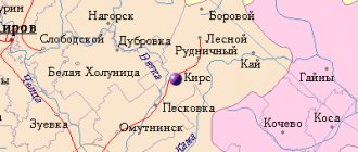
| Kotelnich. Nearest cities. Distances in km. on the map (in brackets along roads) + direction. Using the hyperlink in the distance , you can get the route (information courtesy of the AutoTransInfo website) | |||
| 1 | Orlov | 41 (47) | NE |
| 2 | Orichi | 43 (69) | IN |
| 3 | Candle | 48 (40) | Z |
| 4 | Darovskaya | 55 (58) | WITH |
| 5 | Verkhoshizhemye | 56 (153) | SE |
| 6 | Arbazh | 68 (79) | YU |
| 7 | Leninskoe | 72 (65) | Z |
| 8 | Murygino | 81 (138) | NE |
| 9 | Pushing | 81 (98) | YU |
| 10 | Kirov | 83 (119) | NE |
| 11 | Sovetsk | 87 (101) | SE |
| 12 | Pizhanka | 93 (135) | YU |
| 13 | Kumeny | 94 (186) | IN |
| 14 | Yurya | 98 (131) | NE |
| 15 | Tonshaevo (Nizhny Novgorod region) | 99 (262) | SW |
| 16 | Pervomaisky | 101 () | NE |
| 17 | Kirovo-Chepetsk | 102 (155) | IN |
| 18 | Bogovarovo (Kostroma region) | 106 (329) | NW |
| 19 | Vakhrushi | 107 (156) | NE |
| 20 | Yaransk | 114 (135) | YU |
| 21 | Suna | 114 (191) | SE |
| 22 | Vokhma (Kostroma region) | 115 (319) | NW |
| 23 | Ponazirevo (Kostroma region) | 117 (114) | Z |
| 24 | Slobodskaya | 117 (144) | NE |
a brief description of
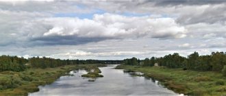
Located in the Volga region, on the high right bank of the river. Vyatka, near the confluence of the river. Moloma, 124 km southwest of Kirov. Port. Road and railway junction lines.
Territory (sq. km): 29
Information about the city of Kotelnich on the Russian Wikipedia site
Historical sketch
The first mention in the chronicles of the settlement of Koksharov on the site of the modern city dates back to 1143. It was renamed Kotelnich in 1181. It was first mentioned in all-Russian chronicles in 1459.
The name comes from the cauldron “deepening, depression, basin”, which is confirmed by the location of the ancient part of the city in the basin. It is possible to trace the pre-Russian name: the Novgorod name of the city of Koksharov back in the 19th century. was interpreted from the Mari koksher as “dried up swamp, hollow.” It is also possible to explain the name from the Russian nickname personal name Kotelnik with the suffix -ichi.
In 1489, together with other Vyatka settlements, it became part of the Moscow state.
It developed as a merchant city on the trade route that connected it with Veliky Ustyug and Arkhangelsk, as well as with the cities of the Volga region. Two highways also passed through Kotelnich, connecting the Vyatka region with Moscow and central Russia. From the 17th century The largest fair in the Vyatka province, the Alekseevskaya Fair, was held here, which, according to legend, was convened in 1647 as a horse trade. In the second half of the 19th century. a large fair was held, supplying food to industrial centers - Nizhny Novgorod, Ivanovo, Shuya, Galich; industrial goods - residents of Vyatka and Kazan provinces.
In 1708, the Vyatka suburb of Kotelnich was assigned to the Siberian province, since 1719 in the Vyatka province. Since 1727 in the same province of the Kazan province. Since 1780, the district town of the Vyatka governorate (since 1796 - the Vyatka province).
In 1856, in the district town of Kotelnich, Vyatka province, there were 4 churches, 345 houses, 24 shops.
At the end of the 19th century. In connection with the development of shipping on Vyatka, the role of Kotelnich as a trading center noticeably decreased.
In 1926, the city was severely damaged by a fire, which destroyed mainly its central part (the city was rebuilt 10 years later). In the 1920-30s. Flax spinning enterprises and a repair base for the shipping company developed in Kotelnich.
Municipal indicators
| Index | 2001 |
| Demography | |
| Number of births, per 1000 population | 6.4 |
| Number of deaths, per 1000 population | 19.7 |
| Natural increase (decrease), per 1000 population | -13.3 |
| Standard of living of the population and social sphere | |
| Average monthly nominal accrued wages, rub. | 2152 |
| Average housing area per inhabitant (at the end of the year), sq.m. | 19.8 |
| Number of preschool institutions, pcs. | 8 |
| Number of children in preschool institutions, thousand people | 0.8 |
| Number of daytime educational institutions (at the beginning of the school year), pcs. | 9 |
| Number of students in daytime educational institutions, thousand people | 3.8 |
| Number of doctors, people. | 135 |
| Number of nursing staff, people. | 639 |
| Number of hospital institutions, pcs. | 4 |
| Number of hospital beds, thousand units | 0.97 |
| Number of medical outpatient clinics, pcs. | 1 |
| Capacity of medical outpatient clinics, visits per shift, thousand units. | 0.5 |
| Number of registered crimes, pcs. | 513 |
| Economy, industry | |
| Number of enterprises and organizations (at the end of the year), pcs. | 379 |
| Construction | |
| Volume of work performed by type of activity “Construction” (until 2004 - volume of work performed under construction contracts), million rubles. | 47.9 |
| Commissioning of residential buildings, thousand sq.m. of total area | 1.5 |
| Commissioning of residential buildings, apartments | 15 |
| Commissioning of preschool institutions, places | 0 |
| Commissioning of educational institutions, places | 0 |
| Commissioning of hospital facilities, beds | 0 |
| Commissioning of outpatient clinics, visits per shift | 0 |
| Transport | |
| Number of bus routes (in intracity traffic), pcs. | 5 |
| Number of passengers transported by buses per year (in intracity traffic), million people. | 6.6 |
| Trade and services to the population | |
| Retail trade turnover (in actual prices), million rubles. | 333 |
| Retail trade turnover (in actual prices), per capita, rub. | 10811 |
| Public catering turnover (in actual prices), million rubles. | 29.6 |
| Volume of paid services to the population (in actual prices), million rubles. | 127.2 |
| Volume of paid services to the population (in actual prices), per capita, rub. | 4129.5 |
| Volume of household services to the population (in actual prices), million rubles. | 43.7 |
| Volume of household services to the population (in actual prices), per capita, rub. | 1417.3 |
| Investments | |
| Investments in fixed assets (in actual prices), million rubles. | 8.5 |
| Share of investments in fixed assets financed from budgetary funds in the total volume of investments, % | 38.5 |
Data sources:
- Regions of Russia. Main characteristics of the constituent entities of the Russian Federation: statistical collection. Goskomstat of Russia. - M:, 2003.
Economy
Food industry: JSC "Butter Factory" (the largest in the region), confectionery factory "Kotelnichhleb", etc. Forestry and woodworking JSC: furniture factory, mast impregnation plant, rafting raid, "Nizhnevyatsklesosplav".
Mechanical engineering: JSC "Micrometer", mechanical repair plant. Light industry: knitting factory.
In the Kotelnichsky district, rye, barley, oats, wheat, flax, and potatoes are grown. Sheep, pigs and cattle are raised.
Deposits of peat, clay, limestone, gravel.
Culture, science, education
Museum of Local Lore.
Universities of the city
Kotelnichesky branch of the Vyatka State Agricultural Academy
612607, Kirov region, Kotelnich, st. Pobeda, 23 WWW: https://www.kcxt-kotelnich.narod.ru/
Architecture, sights
The territory of the city is intersected by 3 large ravines, along the bottom of which the rivers Balakirevitsa, Rodionovka and Kotlyanka flow. Construction according to the plan was carried out only in the central part of the city. The main street (Moskovskaya) was built up in the 1850s-80s. in the “Vyatka provincial style”.
There were 2 monasteries: the male Predtechensky and the female Vvedensky.
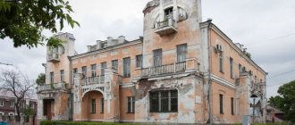
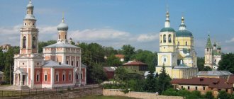
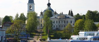
The city is divided into 2 main urban areas (eastern and western), separated by the railway. knot. Modern buildings are dominated by 3-5-story buildings from the 1950s and 60s. The Trinity Cathedral (1713), St. Nicholas Church (1903), and the former Gostiny Dvor (1856) have survived.
Up the river Moloma, in the village of Yuryevo, - Elias Church (1767) with a bell tower and a refectory (mid-19th century).
Natural monuments are protected in Kotelnich and its environs: Nurgushsky reserve, oak grove, landslide near the village of Klimichy; right bank of the river Vyatka from the village of Mukha to the village of Vishkil (the location of the remains of fossil pareiasaurs, one of the largest in the world).
| Population by year (thousands of inhabitants) | |||||||
| 1856 | 2.6 | 1979 | 32.8 | 2005 | 27.6 | 2014 | 24.5 |
| 1897 | 4.2 | 1989 | 36.8 | 2006 | 27.4 | 2015 | 24.3 |
| 1913 | 4.6 | 1992 | 38 | 2007 | 27.0 | 2016 | 24.2 |
| 1931 | 10.7 | 1996 | 33.3 | 2008 | 26.6 | 2017 | 24.0 |
| 1939 | 18.5 | 1998 | 32.4 | 2010 | 25.9 | 2018 | 23.7 |
| 1959 | 27.7 | 2000 | 31.5 | 2011 | 25.0 | 2019 | 23.2 |
| 1967 | 29 | 2001 | 31.2 | 2012 | 24.9 | 2020 | 22.9 |
| 1970 | 29.2 | 2003 | 28.2 | 2013 | 24.7 | 2021 | 22.5 |
home
Historical information about the city of Kotelnich
The city of Kotelnich is the oldest urban settlement in the Kirov region. On February 1, 1963, by Decree of the Presidium of the Supreme Soviet of the RSFSR, it was removed from the administrative district and classified as a city of regional subordination, and since 2004 - a city district.
Located in the middle reaches of the Vyatka River. The population is 22.5 thousand people. (2021), of which 240 people. lives in the left bank part, communication with which is carried out through river transportation. Opposite the city across the river there is a natural monument of regional significance - an oak grove.
The historical center of the city is located on the right high bank of the Vyatka River in a deep (up to 35 m) and wide basin, along the bottom of which the Balakirevitsa River flows. According to archaeologists, the first Russian settlement near its mouth appeared at the end of the 13th – beginning of the 14th centuries. (Kotelnichskoye settlement) and was located near the border of settlement of the Mari tribes (Cheremis). A local source (“The Tale of the Vyatka Country”) dates this event to 1181, reporting that initially the city was called Koshkarov (Koksharov), and only later began to be called Kotelnich. During the Slavic colonization from the northern possessions of the Rostov-Suzdal principality (lands along the Sukhona River, Northern Dvina, Veliky Ustyug), the Kotelnich group of the population was formed around it, which was distinguished from the Vyatchans of the northern territories by a special clinking dialect. Its features remained in the speech of local residents until the second half of the twentieth century.
In Russian chronicles, Kotelnich was first mentioned in 1459. Until the end of the 16th century. the city functioned as a border fortress, first of the Vyatka Land, and from 1489 of the Moscow state. Its area reached 4 hectares. The Moscow Highway and the river route to Veliky Ustyug passed through the city.
Since the 17th century Kotelnich is the administrative center of the county, and since 1929 - the district. Since 1784 it was built according to the General Plan. By 1917, it had 5 long streets (run parallel to the bank of the Vyatka River) and 7 transverse ones, 3 shopping areas, a cathedral and 4 churches. Its territory was about 2 sq. km. (without forests and agricultural lands), population 6 thousand people. The economy was focused on serving trade. Through the pier there was trade in agricultural products with the cities of the north-west and the Volga region.
From 1647 to 1929, the Alekseevskaya Fair was held annually in the city. In the second half of the 19th century it was the largest peasant fair in the empire. With a turnover of 1 to 2 million rubles. Over the years, it took places from 7th to 22nd among similar trades in Russia. Renewed in 2007
During the imperial period, a significant contribution to the development of the city was made by the city mayors, merchants of the first guild Mikhail Ivanovich Kardakov (1856-1859) and Andrei Prokopyevich Kardakov (1862-1869), merchant of the second guild Alexey Yakovlevich Zubarev (1902-1906). The merchant S.S. Zyrin and the merchant's wife M.F. left their mark through their charitable activities. Samodelkina.
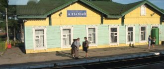
Since the beginning of the twentieth century, Kotelnich began to develop as a transport hub. Through the city on its western outskirts were built in 1902-1906 and 1913-1927. railways connecting St. Petersburg and Moscow with the eastern regions of the country, and later federal highways R-176, R-243.
On May 26, 1926, the city was almost completely destroyed by a major fire. Out of 11 thousand residents, 7 thousand people were left without a roof over their heads. The scale of the destruction raised the question of the future fate of Kotelnich for the authorities. It was proposed to leave it as a village. The need to restore the city was demonstrated to the provincial and republican authorities by the chairman of the Kotelnichsky district executive committee (1925-1929) Vladimir Grigorievich Vaneev. He was supported and made a great contribution to the restoration of the city by the secretary of the regional committee of the CPSU (b) (1925-1927) Azary Ivanovich Myshkin.
From the first days of the Great Patriotic War of 1941-1945. Kotelnich became a major mobilization and evacuation center in the Kirov region. Due to the evacuated population from Leningrad, Pskov, Novgorod and Leningrad regions, the number of residents increased from 18 (1941) to 32.5 thousand people. The city had 4 evacuation hospitals with 3,300 beds. After treatment, up to 50 thousand soldiers and commanders returned to duty and were sent to the front. In January-February 1942, the 109th Rifle Brigade was formed in Kotelnich, on the basis of which the 5th Oryol Rifle Division was later created. Local enterprises switched to producing products for the front. In wartime conditions, the work of the city council was led by Konstantin Grigorievich Novozhilov - until February 10, 1942 and Joseph Stepanovich Vokhmyanin - until 1945.
In 2010, on the site of the old railway station, on the initiative of the Vyatka Land charity foundation and with the support of the Governor of St. Petersburg V.I. Matvienko, a memorial was opened on the Gorky Railway, on the granite slabs of which the memory of 2,768 citizens of the Soviet Union who died en route during the evacuation from hunger, cold, disease and those who died in Kotelnich is immortalized.
For the labor heroism of the population during the war, by Decree of the Governor of the Kirov Region dated December 3, 2012, Kotelnich was awarded the honorary title “City of Labor Glory.”
During the Soviet period, as a result of industrial and economic construction, the city's territory increased to 29.4 sq. km. In 1989, the population reached a maximum of 36.8 thousand people, and then began to decline.
The construction of new microdistricts proceeded in a western direction from the railway, which divided the city into two parts: the eastern with the historical center and the western with buildings of the second half of the twentieth century. In the eastern part, the historical environment was predominantly disturbed. In the 30s of the twentieth century. The Trinity Cathedral, the Baptist Church, and the Church of Cyril and Methodius, located on the main street of the city, Moskovskaya, were demolished. Industrial enterprises and a river port were located on the central square and the associated coastal strip. As a result, the exit to the river from the center of the historical part was blocked. Currently, most of this territory is cleared of industrial premises and can be involved in urban planning activities.
Despite the losses, in the historical part of the city the layout of streets and blocks according to the General Plan of 1784, a significant part of the ordinary residential and public buildings of the mid-19th - early 20th centuries, has been preserved. The buildings of St. Nicholas Cathedral and the residential building of the merchant Lebedev were put on federal registration. 52 city-forming objects were recommended for state protection, incl. Gostiny Dvor buildings with 160 shops, a public bank, a district hospital, a zemstvo government, a city Duma, a women's gymnasium, a post office, a power plant, a water tower, a fire station, red barracks, arrest premises and police officer's housing, etc.
In the modern period, Kotelnich gained fame in connection with excavations at the Kotelnich site of pareiasaurs - one of the largest in the world. The location was discovered in 1933. The period of active excavations began in the 90s of the twentieth century. Along with Russian scientists, researchers from Australia, Canada, and Germany took part in them. During the work, more than 20 species of ancient dinosaurs that lived 220-250 million years ago were discovered, previously unknown to science. Based on the collections of finds, a paleontological museum was created in 1994 (currently a branch of the Vyatka paleontological museum). In 2012, in the center along the banks of the Balakirevitsa River on an area of 3.5 hectares. Dinopark was built, which helped attract attention to the city from tourists, whose number increased to 25 thousand people. in year. Meanwhile, the museum and the Dinopark are geographically distant. The construction of a paleontological museum building on the territory of the Dinopark, the expansion and creation of modern exhibitions would open up new opportunities for the development of tourism.
A promising direction for the development of the city is the continuation of work on the construction of the embankment in its historical part, which began in 2014. Observation platforms have been created along the high river bank up to 40 m, connected by pedestrian paths with access to the river. Continuing the work will make it possible to reach empty lands on the coastal strip of the historical center and create new public spaces here, which are lacking today due to dense development.