Krasnoslobodsk
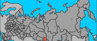
(Volgograd region)
OKATO code:
18251507
Founded: Urban settlement since:
1938
City since:
1955 City of district subordination (Sredneakhtubinsky district, Volgograd region)
The city was formerly called:
| Krasnaya Sloboda | 1955 |
Deviation from Moscow time, hours:
0
Geographic latitude:
48°42′
Geographic longitude:
44°34′
Altitude above sea level, meters:
0 Sunrise and sunset times of the Sun and Moon in the city of Krasnoslobodsk
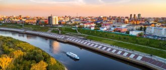
The city of regional subordination of Krasnoslobodsk is located in the Sredneakhtubinsky district of the Volgograd region. Located on the left bank of the Volga . Exactly opposite the Krasnoslobodsk on the other bank is the central embankment of Volgograd. The only city in the Volgograd region, located inside the Volga-Akhtuba floodplain, that is, between the Volga and Akhtuba .
The population of the city is 14.5 thousand people.
The history of the development of this city originates from the small village of Bukatin. It was named after its founder, a Cossack, who in 1870 moved from Tsaritsyn to the other side in search of a well-fed life. Those plots that were allocated to the Cossacks in Tsaritsyn were very small, and the territory beyond the Volga was not developed, green pastures for livestock, a lot of fish in the lakes, untouched forests. Bucatin's family managed to settle there, and later others began to join them.
In 1923, at the request of his grandson, the farm was renamed Krasnaya Sloboda.
The population grew and grew, and in 1938 the farm was given the official title of “working village”.
Since 1955, it received city status. In the same year it was renamed Krasnoslobodsk . The name has survived to this day.
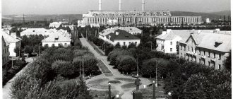
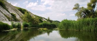
Today Krasnoslobodsk is a small, very quiet town, the houses are mostly one-story, there are even wooden ones with carved platbands. The city is famous for its small ponds, rivers, and sandy beaches, where both locals and Volgograd residents often come to relax in nature. The most popular tourist places are the island of Crete, the central city beach and Elm Mane.
Together with Volzhsky, Krasnoslobodsk is part of the Volgograd agglomeration. Communication between the two cities is carried out by ferry. the Volga opened . Now you can get to the other side using vehicles or regular buses.
In May 2010, strong vibrations of the bridge were recorded, which led to a stop in traffic on it. The question of the safety of the bridge design, which is now called the “dancing” bridge, has not yet been clarified.
Near Krasnoslobodsk there is a unique natural formation - the Volga-Akhtuba floodplain . Nature has been preserved here, untouched, in its original form: various types of trees, ferns, swamps with all the splendor and diversity of vegetation.
On the territory of the Volga-Akhtuba floodplain there are many architectural monuments located along the same line. Apparently, in the past the Great Silk Road passed there. The local history museum stores evidence of antiquity and various archaeological finds.
Telephone code: +7 84479 Official website of the city: www.krasnoslobodsk34.ru
Map
| Krasnoslobodsk: maps |
Krasnoslobodsk: photo from space (Google Maps) Krasnoslobodsk: photo from space (Microsoft Virtual Earth)
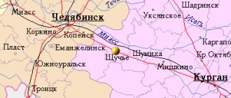
| Krasnoslobodsk. Nearest cities. Distances in km. on the map (in brackets along roads) + direction. Using the hyperlink in the distance , you can get the route (information courtesy of the AutoTransInfo website) | |||
| 1 | Volgograd | 4 (60) | Z |
| 2 | Settlement | 12 (12) | NW |
| 3 | Volzhsky | 17 (32) | NE |
| 4 | Srednyaya Akhtuba | 22 (20) | IN |
| 5 | Erzovka | 26 (38) | WITH |
| 6 | Svetly Yar | 29 (58) | SE |
| 7 | New Rohachik | 37 (44) | Z |
| 8 | Dubovka | 43 (113) | NE |
| 9 | Leninsk | 46 (78) | Z |
| 10 | Kalach-on-Don | 75 (140) | Z |
| 11 | Ilovlya | 79 (90) | NW |
| 12 | Malye Derbets (Republic of Kalmykia) | 83 () | YU |
| 13 | Znamensk | 86 (123) | IN |
| 14 | Kapustin Yar (Astrakhan region) | 88 () | IN |
| 15 | Sadovoye (Republic of Kalmykia) | 103 (123) | YU |
| 16 | October | 106 (163) | SW |
| 17 | Bolshoi Tsaryn (Republic of Kalmykia) | 114 (173) | SE |
a brief description of
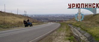
Located on the left bank of the Volga opposite Volgograd, 5 km from the railway. Volgograd-I station. Highway.
Territory (sq. km): 104
Information about the city of Krasnoslobodsk on the Russian Wikipedia site
Historical sketch
The Bakatin farmstead, named after the first settler, was renamed the Krasnaya Sloboda village after 1917.
Since 1938, the working village of Krasnaya Sloboda. Since 1955 the city of Krasnoslobodsk.
Economy
Factories: shipbuilding and ship repair, fishing.
Culture, science, education
Experimental station of the Institute of Plant Growing.
Museum of Local Lore.
| Population by year (thousands of inhabitants) | |||||||
| 1939 | 15.6 | 1996 | 13.1 | 2007 | 14.6 | 2015 | 17.0 |
| 1959 | 19.0 | 1998 | 13.3 | 2008 | 14.6 | 2016 | 17.4 |
| 1967 | 19 | 2000 | 13.3 | 2010 | 14.5 | 2017 | 17.4 |
| 1970 | 17.7 | 2001 | 13.3 | 2011 | 16.0 | 2018 | 17.3 |
| 1979 | 16.0 | 2003 | 14.4 | 2012 | 16.1 | 2019 | 17.3 |
| 1989 | 13.5 | 2005 | 14.5 | 2013 | 16.4 | 2020 | 17.1 |
| 1992 | 12.9 | 2006 | 14.6 | 2014 | 16.7 | 2021 | 16.8 |
City of Krasnoslobodsk, Volgograd region
Russia \ Volgograd region \ Cities and villages
Coordinates: N48 42.186 E44 33.024.
Krasnoslobodsk is located opposite Volgograd, on the left bank of the Volga River. The city of Krasnoslobodsk, Volgograd region , is the only settlement located between two rivers - the Volga and Akhtuba. The history of the city began at the end of the 19th century - then on the site of modern Krasnoslobodsk stood the Bukatin farmstead, named after its founder, the Cossack settler Agey Bukatin.
The birth of the Bukatin farm is closely connected with the history of the appearance of the Cossacks in the south of Russia. The appearance of the first Don Cossacks dates back to 1721, when Peter the Great settled the first Cossack detachments between Kamyshin and Tsaritsyn. Terrible living conditions forced the Cossacks to escape, so in 1730 a special Volzhskoe army was created to track down fugitives and thieves. After the abolition of the Tsaritsyn guard line, the Cossacks were resettled: some to the Caucasus, another part settled among the residents of Tsaritsyn, and still others received part of the land in the Rossoshinsky district. The farms located in this area were poor in contrast to the fertile lands and “fishy” edges of the left bank of the Volga. Agey Bukatin, like most other Tsaritsyn Cossacks, was unloading logs from rafts. Gradually, the size of the Cossack population increased, but the merchants of Tsaritsyn did not want to share the city lands with the Cossacks. And here the left bank of the Volga attracts with its forests, deep rivers and fertile lands. And in 1870, Agey Bukatin received 4,500 acres of land on the left bank of the Volga: from this moment the rapid development of the left bank of the Volga and the construction of the Bukatin farm (the future Krasnoslobodsk, Volgograd region) began. Some time after the resettlement, houses, stables, wells and barns appear in the village. A pharmacy, a church and a wine shop open. Over 300 people lived in the Bukatin farmstead. The location of the farm was considered one of the best in the Astrakhan province: fertile lands made it possible to grow vegetables and fruits and raise livestock, and its proximity to Tsaritsyn made it possible to maintain trade relations with the city.
A few years after Bukatin’s death, on the initiative of his communist grandson Nikolai Bukatin, the farm was given a different name - Krasnaya Sloboda. In 1938, the farm received the status of a workers' village of Krasnaya Sloboda, and a few years later acquired the official name, which we hear to this day - the city of Krasnoslobodsk.
There are two factories in the city of Krasnoslobodsk: a fishery and a shipbuilding one. The latter is currently not functioning and has practically stopped working. There is an experimental station at the Vavilov Institute of Plant Growing in Krasnoslobodsk. N.I.
Previously, Krasnoslobodsk was connected with Volgograd only by passenger and car ferries, however, the construction of a new Volgograd bridge, which began back in 1996, was completed in 2009. In connection with the construction of the bridge across the Volga in Krasnoslobodsk, prices for real estate and land plots increased significantly. Immediately after its construction, the Volgograd bridge became famous throughout the country for its “dancing”: in May 2010, strong vibrations, the cause of which has not been precisely clarified to this day, led to a stop in traffic on the bridge.
At the moment, the car ferry from Volgograd to Krasnoslobodsk does not operate; the passenger ferry continues to operate.
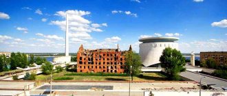
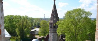
There are several churches in Krasnoslobodsk, Volgograd region, one of which was built about a hundred years ago. The Church of St. Nicholas the Wonderworker was founded at the beginning of the 20th century. During the Soviet period (in 1945), as usual, most churches were closed: their number included the Church of St. Nicholas the Wonderworker in Krasnoslobodsk. The construction of the temple itself and utility premises was completed at the beginning of the 21st century - in 2008. In honor of St. Nicholas the Wonderworker, a Poklonny cross was erected on the embankment of Krasnoslobodsk.
In addition, a new educational Orthodox monastery complex of Archangel Michael is being built on the embankment of Krasnoslobodsk and will soon open its doors.
Add photo/information
Links[edit]
Notes[edit]
- ^ abcdef State Committee of the Russian Federation on Statistics. Committee of the Russian Federation for Standardization, Metrology and Certification. No. OK 019-95 January 1, 1997 “All-Russian classifier of objects of administrative-territorial division. Code 18 251 507", as amended. changes No. 278 / 2015 dated January 1, 2016. (Goskomstat of the Russian Federation. Committee of the Russian Federation for Standardization, Metrology and Certification. No. OK 019-95 January 1, 1997. Russian classification of administrative divisions) (OKATO).
Code 18 251 507 , as amended by Amendment No. 278/2015 of January 1, 2016). - ^ a b Federal State Statistics Service (2011). “All-Russian Population Census 2010. Volume 1" [All-Russian Population Census 2010, vol. 1]. All-Russian Population Census 2010 [All-Russian Population Census 2010]
. Federal State Statistics Service. - "26. The size of the permanent population of the Russian Federation by municipalities as of January 1, 2022". Federal State Statistics Service. Retrieved January 23, 2022.
- ^ abcde Law No. 1040-OD
- "On the Calculation of Time". Official Internet portal of legal information
. June 3, 2011. Retrieved January 19, 2022. - Post office. Information and computing center of OASU RPO. ( Post office
).
Search for postal service objects ( postal Search for objects
) (in Russian) - ↑
Federal State Statistics Service of Russia (May 21, 2004).
“The population of Russia, the constituent entities of the Russian Federation as part of federal districts, urban settlements, settlements, settlements is 3 thousand or more people” [Population of Russia, its federal districts, federal districts, districts Urban settlements, rural settlements - administrative centers and rural settlements with a population of over 3,000] (XLS). All-Russian Population Census 2002
. - “All-Union Population Census of 1989. The current population of union and autonomous republics, autonomous regions and districts, territories, negative phenomena, urban settlements and rural district centers” [All-Union Population Census of 1989: current population of union and autonomous republics, Autonomous regions and districts , territories, regions, districts, towns and villages performing the functions of district administrative centers. All-Union Population Census of 1989 [All-Union Population Census of 1989]
.
Institute of Demography of the National Research University: Higher School of Economics [Institute of Demography of the National Research University: Higher School of Economics]. 1989 - via Demoscope Weekly
.
Administrative and municipal status[edit]
In the administrative-territorial division, it, together with three rural settlements, is included in the Sredneakhtubinsky district as the city of regional significance of Krasnoslobodsk
.
[1] As a municipal entity, the territory of Krasnoslobodsk and two rural settlements are included in the Sredneakhtubinsky municipal district as the urban settlement of Krasnoslobodsk
.
[4] The remaining rural area (the hamlet
of Sakharny) is included as part of the Frunzensky rural settlement in the Sredneakhtubinsky municipal district. [4]
History[edit]
It was founded as a farm
from
Bucatin
(Bucatin).
[ citation needed
] After 1917 it was renamed
Krasnaya Sloboda
(Krasnaya Sloboda).
[ citation needed
] In 1955 it was given its current name and city status.
[ citation needed
] Krasnaya Sloboda was a suburb of Stalingrad and in the western regions of Krasnaya Sloboda. Krasnaya Slovboda was in 1942-1943, when the Germans were on the outskirts of the suburb of Krasnaya Sloboda and where Poles were killed in and out of the Katyn Forest on the street.