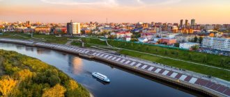
NOVOKUZNETSK , a city of regional subordination of the Kemerovo region, the center of the district of the same name; located in the Kuznetsk Basin, on the Tom River, at the confluence of the Aba and Kondoma rivers, 308 km south of Kemerovo. Junction of railway lines and roads. Airport.
From 1618 - Kuznetsk fort, from 1622 - the district city of Kuznetsk or Kuznetsk-Sibirsky, from 1804 - the center of the Kuznetsk district (1822-97 - district) of the Tomsk province, from 1924 - a regional center, in 1932 merged with Garden City into the city of Novokuznetsk, in the same year it was given the name Stalinsk, from 1939 - the regional center of the Novosibirsk region, from 1943 - the Kemerovo region, from 1961 - renamed Novokuznetsk.
General information
Russia, Kemerovo region, Novokuznetsk - the exact address of the location of the settlement. The unofficial name is the Southern capital of Kuzbass.
The historical map of the city (Novokuznetsk) notifies that this city in the Kemerovo region is the thirteenth largest city in the country. The population is more than five hundred and fifty thousand people. Among settlements that are not constituent entities of the Federation, it ranks second.
The density is about one thousand three hundred people per square kilometer.
The city of Novokuznetsk, Kemerovo region is the center of the Kuzbass agglomeration. The total population living near the settlement is almost one and a half million people.
The center of industry is the city of Novokuznetsk. The region in which the settlement is located is Kemerovo, bordering the Tomsk and Novosibirsk regions. Also nearby is the border with the Krasnoyarsk, Altai Territories and the Republic of Khakassia.
A major center of coal mining is the city of Novokuznetsk. Large coal basin area.
Postal codes - from 654000 to 654103.
Telephone code – 3843. Six-digit numbering of the city network.
Vehicle codes are 42 and 142.
City Day is celebrated on the first Sunday in July.
It is on the list of the best thirty cities in the Russian Federation for doing business.
There are branches of more than forty banks in the city.
The main population is young people aged 20-45 years.
Interesting Facts
Geographical data
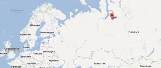
The city of Novokuznetsk - Kemerovo region. The settlement is located in the south of Western Siberia.
Novokuznetsk on the map of Russia is located on the banks of the Tom River. Geographical location - south of the Kemerovo region.
Novokuznetsk on the map of Russia is located in the time zone of the Krasnoyarsk Territory, which is the seventh according to Greenwich Mean Time. Relative to the capital of the Russian Federation - plus four hours.
The distance to Moscow is just under four thousand kilometers by road. To get to the regional center, the city of Kemerovo, you will have to cover a little more than two hundred and twenty km.
The city map (Novokuznetsk) indicates that the settlement is divided into six districts. The area is just over four hundred twenty-four square kilometers. The altitude above sea level is one hundred and ninety meters.
The climate is sharply continental and dry. Significant annual temperature fluctuations. The average annual value is approximately two degrees Celsius.
The minimum value is minus fifty-two, the maximum is thirty-eight.
The number of sunny days is about two hundred and eighty.
The average precipitation is six hundred millimeters. Soil freezing is up to two meters. The average wind speed is two and a half meters per second.
What is mined in Tashtagol?
The Tashtagol mine is the only one in Russia where work is carried out on seven horizons simultaneously. In total, over the years of work, the miners of the Tashtagol mine produced more than 135 million tons of raw ore. As of March 2022, it is the Tashtagol mine of the ZSMK mining department.
Interesting materials:
The monitor screen has narrowed, what should I do? The monitor screen has narrowed, how can I get it back? Cracks on the tablet screen, what should I do? The screen is cracked, what should I do? The screen on my smartphone is cracked, what should I do? The monitor screen has become smaller, what should I do? How to fix a narrow screen on a monitor? What is the main difference between an IPS screen and a TN TFT screen? An advertisement appears in the corner of the screen, how can I remove it? Why do you need a firewall?
Story
The settlement was founded in 1618 as the Kuznetsk fort. In 1622 it received city status.
At the beginning of the eighteenth century, gold was discovered in these areas, which contributed to strong economic growth. Unfortunately, it didn't last long.
The modern city begins its countdown on the third of July 1931 by uniting the cities of Kuznetsk and Novokuznetsk. The city owes its appearance to the construction plant, which was just under construction at that time.
In 1929 the first stone of the metallurgical giant was laid. In 1931 he began his work.
During the war, he carried out important orders for the production of combat vehicles, tanks, and shells.
The settlement was initially destined for the role of an important coal mining and industrial center. Novokuznetsk was even glorified in the work of Vladimir Mayakovsky, “Khrenov’s Story about Kuznetskstroy and the People of Kuznetsk.”
In 1932 the city was renamed Stalinsk. In 1961 it again received its original name - Novokuznetsk.
Popular message topics
- Christopher Columbus
The exact date of birth of Christopher Columbus is unknown to historians, but it most likely was between August 25 and October 31, 1451 in Genoa. The future tireless traveler was the son of a Genoese weaver and spent the first years of his adult life - Art of the Renaissance
The Renaissance (otherwise known as Renaissance) began in the 14th century and lasted until about the 16th-17th centuries. There are no exact dates, since the onset and duration of this period depended on the characteristics of the development of a particular country. - Amanita Amanita
Amanita is a mycorrhiza-forming lamellar mushroom. It belongs to the Amanitaceae family. Most fly agarics should not be eaten as food, as they contain toxic substances. The Fly Agaric family consists of 600 species.
Industry
One of the oldest cities in Siberia is Novokuznetsk. What area of industry is developed here!
The basis of the potential is the production of finished metal products, mining, production and distribution of electricity. The largest enterprises are the West Siberian Metallurgical Plant (ZSMK), the Novokuznetsk Metallurgical Plant (NKMK), aluminum and ferroalloy plants. Rail rental has been developed.
Coal industry: large mines and large coal mining companies.
Mechanical engineering: production of mining equipment, sanitary products, etc.
Powerful construction companies, including KuzbassTransStroy, Kuznetskpromstroy, Kuzbassshakhtostroymontazh.
There is also a timber industry, a food industry - a distillery, a confectionery factory, a food processing plant, and a dairy company. The production of baby food has been established.
Chemical, pharmaceutical, medical and light industries are also developed.
Powerful electricity producer – Novokuznetsk. What region can boast such a powerful tandem of enterprises?
Kuznetskaya CHPP is a coal-fired thermal power plant. The generated power is one hundred and eight megawatts of energy.
In addition, there is the Central Thermal Power Plant, the Novokuznetsk Gas Thermal Power Plant, and the West Siberian Thermal Power Plant.
Additionally, in addition to its own electricity generation to supply adjacent mines and settlements, the population is supplied with hot water.
In total, there are about forty enterprises in the city.
Due to the presence of powerful production, the environmental situation leaves much to be desired. Local waters have high levels of iron, magnesium, copper, and petroleum products.
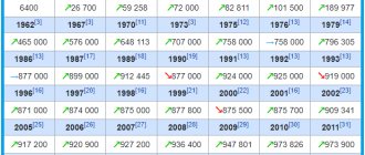
Population gain or loss according to the census
The total and official population of the city of Novokuznetsk, how many people live in it as of January 1, 2022, the number of people in each individual city district and municipality, further in the second table.
| Year | Growth/decrease population city of Novokuznetsk |
| 2017 | ↗552,445 people |
| 2018 | ↗553,638 people |
| 2019 | ↘552 105 people |
| 2020 | ↘549 103 people |
| 2021 | ↘544,583 people |
| 2022 |
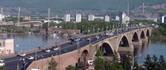
Railway transport
Of course, the population is not in the city (Novokuznetsk) all the time. What region and region is not connected with this wonderful settlement!
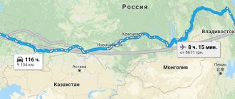
Novokuznetsk is a large railway junction. From the central station you can get to almost every corner of the Russian Federation. The most popular are trains to Moscow, St. Petersburg, Novosibirsk, Vladivostok, Tomsk, Barnaul, Adler, Anapa.
Communication within the region has been developed.
International connections – Kazakhstan and Kyrgyzstan.
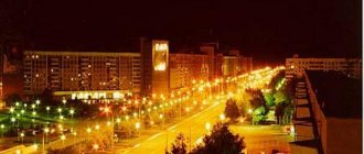
Novokuznetsk city photo. Photo of Novokuznetsk
On our website you will find photographs of Novokuznetsk from different years. Novokuznetsk photo of the city in different years from Soviet times to the present day.
Information about the city of Novokuznetsk on Wikipedia: Novokuznetsk
Link to Novokuznetsk website. You can get a lot of additional information by reading it on the official website of Novokuznetsk, the official portal of Novokuznetsk and the government. Official website of Novokuznetsk
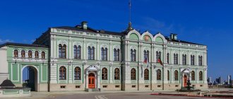
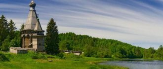
Attractions
Novokuznetsk is famous for its culture. Which region can boast a fortress-museum and a house in which Fyodor Mikhailovich Dostoevsky himself lived for some time?
Novokuznetsk can. In addition, there is a palace of culture and technology, busts and monuments to outstanding people and objects - Alexander Vasilyevich Suvorov, Vladimir Lenin, Yuri Gagarin, Sergei Kirov, Georgy Konstantinovich Zhukov, Maxim Gorky, Lev Nikolaevich Tolstoy, the Russian penny. It is also worth visiting cinemas, drama and puppet theaters, several obelisks, cathedrals and temples, a chapel, a local history museum, a wine warehouse, libraries, a circus, shopping and entertainment complexes, and markets.
In addition, you can while away the time in the planetarium, city parks of culture and recreation, public gardens, landscape monuments, visit a waterfall or the largest bowling club in Siberia.
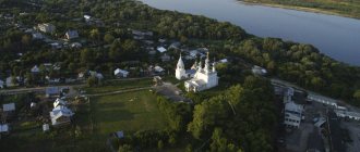
The historical center will delight you with ensembles from the eighteenth and nineteenth centuries. Several old buildings have been preserved.
The famous fortress was built by order of Paul the First at the beginning of the nineteenth century.
Population census of Novokuznetsk, how many people live on January 1?
What is the official population of Novokuznetsk for 2022, how many people live according to the census, how many people are in urban areas as of January 1, trends in profit and loss, whether their number is increasing or decreasing, such questions are of interest to many and we will try to get answers to them.
The city of Novokuznetsk with all its administrative districts is part of the Russian Federation, the administrative center of the Novokuznetsk administrative (municipal) district, which it is not included in, forms the Novokuznetsk urban district.
We will look into the population of the city of Novokuznetsk, how many people live as of January 1, 2022, and how many people officially live in urban areas.
What is the population of the city of Novokuznetsk?
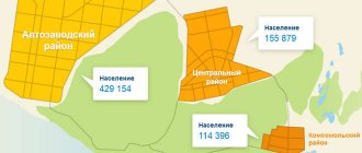
The city consists of six intra-city districts that are not municipalities:
| Area | Area, km² | Population (2021) |
| Factory | 109,10 | ↘95,081 people |
| Kuznetsky | 36,11 | ↘48,344 people |
| Kuibyshevsky | 92,49 | ↘77,773 people |
| Novoilinsky | 22,49 | ↘76,285 people |
| Ordzhonikidzevsky | 95,62 | ↘82,585 people |
| Central | 66,52 | ↘164,515 people |
With the population of the city of Novokuznetsk as of January 1, 2022, how many people live in this territory, people in municipalities and this locality, this territorial unit of the Russian Federation, that’s what we figured out here, we made our contribution to satisfying the requests of those interested in this statistical information .