| Flag of Shchuchye (Kurgan region) | |
| A country | Russia |
| Subject of the federation | Kurgan region |
| Municipal district | Shchuchansky |
| Timezone | UTC+6 |
| Vehicle code | 45 |
| Postcode | 641010 |
| Population | ▲11,019[1] people (2010) |
| OKATO code | 37 244 501 |
| Telephone code | +7 35244 |
| Based | 1750 |
| City with | 1945 |
| Chapter | Tamakhin Vladimir Nikolaevich |
| Ethnobury | schuchany, schuchanka, schuchanets |
| Coordinates | Coordinates: 55°13′00″ N. w. 62°46′00″ E. d. / 55.216667° s. w. 62.766667° E. d. (G) (O) (I) 55°13′00″ n. w. 62°46′00″ E. d. / 55.216667° s. w. 62.766667° E. d. (G) (O) (I) |
| Official site | https://www.shuche.ru |
| Center height | 165 m |
| National composition | Russians, Tatars, Bashkirs |
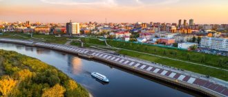
Shchuchye is a city (since 1945) in Russia, the administrative center of the Shchuchansky district of the Kurgan region.
Population - 11.0 thousand people (2010). Shchuchye is the eighth most populous city in the Kurgan region (as of January 1, 2010).
Transport
Transport hub (railways and highways; Trans-Siberian Railway).
Federal highways
The Baikal highway M51 passes through (Chelyabinsk - Kurgan - Petropavlovsk (Kazakhstan) - Omsk - Novosibirsk).
Railway transport
The South Ural Railway crosses the city's territory from west to east. The city is located on the Chelyabinsk - Shumikha railway line. Suburban traffic serves 2 directions: western (Kayasan, Chelyabinsk), eastern (Shumikha, Kurgan). Carried out by electric trains.
Map
| Shchuchye: maps |
Shchuchye: photo from space (Google Maps) Shchuchye: photo from space (Microsoft Virtual Earth)
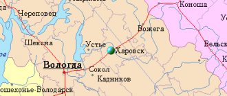
| Shchuchye. Nearest cities. Distances in km. on the map (in brackets along roads) + direction. Using the hyperlink in the distance , you can get the route (information courtesy of the AutoTransInfo website) | |||
| 1 | Safakulevo | 28 (30) | SW |
| 2 | Hype | 32 (34) | IN |
| 3 | Miasskoe (Chelyabinsk region) | 55 (58) | Z |
| 4 | Almenevo | 59 (83) | SE |
| 5 | Mishkino | 73 (80) | IN |
| 6 | Kopeisk | 74 (109) | Z |
| 7 | Etkul (Chelyabinsk region) | 87 (136) | SW |
| 8 | Chelyabinsk | 87 (94) | Z |
| 9 | Rose (Chelyabinsk region) | 90 () | Z |
| 10 | Oktyabrskoye (Chelyabinsk region) | 90 (232) | YU |
| 11 | Dolgoderevenskoye (Chelyabinsk region) | 91 (114) | Z |
| 12 | Kunashak (Chelyabinsk region) | 93 (174) | NW |
| 13 | Korkino | 94 (126) | Z |
| 14 | Roshchino (Chelyabinsk region) | 95 () | Z |
| 15 | Tselinnoe | 97 (124) | SE |
| 16 | Yemanzhelinsk | 106 (145) | SW |
| 17 | Poletayevo (Chelyabinsk region) | 107 () | Z |
| 18 | Yurgamysh | 108 (116) | IN |
| 19 | Zauralsky (Chelyabinsk region) | 108 (141) | SW |
| 20 | Pervomaisky (Chelyabinsk region) | 109 () | Z |
| 21 | Shadrinsk | 110 (235) | NE |
| 22 | Kurtamysh | 111 (253) | IN |
| 23 | Dalmatovo | 117 (231) | WITH |
| 24 | Krasnogorsky (Chelyabinsk region) | 119 (168) | SW |
a brief description of
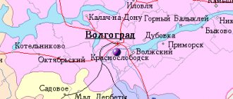
The city is located in the Trans-Urals, 180 km west of Kurgan. Railway station.
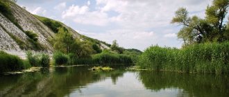
There are over 140 lakes on the territory of the Shchuchansky district, incl. natural monument Lake Gorkoye-Victoria (water of the sulfate-chloride-magnesium-sodium type; significant reserves of silt mud and brine, the medicinal properties of which have been used since 1910; the children's sanatorium "Lake Gorkoye" has been operating since 1955).
Territory (sq. km): 35
Information about the city of Shchuchye on the Russian Wikipedia website
Historical sketch
Known since 1750 as a village. In 1895, during the construction of the Omsk Railway, the Chumlyak station grew near the village of Shchuchye (the station opened in 1896). The name of the station is from the neighboring village of Chumlyak, through which, according to the original design, the route was supposed to pass. In 1974, the station was renamed Shchuchye.
Since 1924, Shchuchye has been a regional center. City since 1945. Name after Lake Shchuchye.
Economy
Fire-fighting engineering plant (including production of fire extinguishers, plastic processing), food processing plant (gingerbreads, cookies). Bakery plant, butter factory, clothing factory (children's, outerwear).
In the Shchuchansky district, mainly grain crops are grown. Animal husbandry for meat and dairy production has been developed.
| Population by year (thousands of inhabitants) | |||||||
| 1939 | 7.6 | 1998 | 10.7 | 2008 | 10.8 | 2016 | 10.0 |
| 1959 | 10.3 | 2000 | 10.9 | 2010 | 11.0 | 2017 | 9.8 |
| 1970 | 10.8 | 2001 | 11.0 | 2011 | 11.0 | 2018 | 9.7 |
| 1979 | 10.4 | 2003 | 10.6 | 2012 | 10.8 | 2019 | 9.6 |
| 1989 | 11.1 | 2005 | 10.7 | 2013 | 10.7 | 2020 | 9.5 |
| 1992 | 11 | 2006 | 10.7 | 2014 | 10.6 | 2021 | 9.3 |
| 1996 | 10.8 | 2007 | 10.7 | 2015 | 10.3 | ||
Industry
- “Shchuchansky military plant for the destruction of chemical weapons” - (Near the city there is an arsenal where stocks of chemical weapons are stored. As part of the federal program for the destruction of chemical weapons, a corresponding enterprise was built.)
- LLC "Schuchansky Bread Products Plant"
- JSC "Shchuchansky Road Repair and Construction Department"
- JSC "Muza" (Flour Mill) - located in the village. Kayasan, Shchuchansky district
- JSC "Schuchansky Elevator"
- JSC "Zauralsky cracker" (Shchuchansky food plant)
Shchuchye
(Kurgan region)
OKATO code:
37244501
Founded:
1750
City since:
1945 City of district subordination (Schuchansky district, Kurgan region)
Center:
Shuchansky district
Telephone code (reference phone)
| 35244***** | 22-2-22 |
Deviation from Moscow time, hours:
2
Geographic latitude:
55°13′
Geographic longitude:
62°46′
Altitude above sea level, meters:
165 Sunrise and sunset times in the city of Shchuchye
Attractions Shchuchye
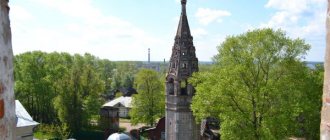
Lake Gorkoye is a hydrological natural monument. The purest salt water and light birch groves surrounding the lake attract thousands of vacationers. But the main advantage of the lake is the miraculous healing power of water and mud. There were summer pioneer camps for recreation and recreation of schoolchildren in the Shchuchansky and Safakulevsky districts. There is a children's psychoneurological sanatorium "Lake Gorkoye-Victoria" of the Ministry of Health of the Russian Federation. From 05/21/2015 it is transferred to the ownership of the Kurgan region. In addition, underground mineral waters have been discovered near the lake. Sculptural memorial monument to the fallen Shchuchans in the Great Patriotic War “To the Warrior - Liberator” (stone, granite). The author of the project is the sculpture N.I. Kondratiev. The monument was unveiled on May 9, 1966. Monument to V.I. Lenin Monument to the liquidators of the accident at the Chernobyl nuclear power plant. Monument to participants in local conflicts Monument to the 25,000th man - Melnik Yakov Petrovich (1899-1930) was brutally killed with his fists. Obelisk and monument with a memorial plaque to PPM factory workers who died during the Great Patriotic War. On the station square there is an obelisk to the Komsomol members and communists who died during the days of the revolution and civil war. Memorial plaque to the staunch revolutionary Mitrofan Ivanovich Chayakov. Memorial plate - installed in memory of historical events in connection with the stay of Marshal G. K. Zhukov in this building. In the village of Planovoye, the “Mourning Stone” was installed in memory of those killed during the unloading of ammunition on January 23, 1945. Foundation stone of the CW plant (2001) Monument - bust of Four-time Hero of the Soviet Union G.K. Zhukov at school No. 3. State natural (zoological) reserve since 2002. An architectural monument of federal significance (Baroque, early 19th century) - the Church of Flora and Lavra in the village of Beloyarskoye. The largest open-air museum of military equipment in the region (18 exhibits) in the city Victory Park. On May 8, 2015, the Eternal Flame was lit at the memorial to the Victorious Warrior. Historical and local history museum in the village of Chumlyak since 1990. (founder of the museum Kayatkina Galina Vasilievna). The only monument in the region to the legendary division commander V.I. Chapaev in the village of Beloyarskoye. Steam roller mill Kolokolnikov S.I. (1909) - a six-story stone building, is an example of industrial architecture of the early 20th century. A memorial stele commemorating the end of the destruction of chemical weapons in the Shchuchan region. The symbol of the city is a pike in the city park. Lake Nifanskoe (on the map of 1805 Bolshoye Shchuchye) is fond of sports. fishing: crucian carp, perch, carp, ripus. Area 5.5 sq. km. depth 4m. Bridge of Lovers (Small architectural form). Chesnokovsky pine forest is a botanical natural monument. Area 595 hectares. "Chumlyaksky" bridge is a railway bridge across the river. Chumlyak (area 2182 km.). Built in 1892. Luxury hotel for former employees of PARSONS. Regional school (college) of the Olympic reserve for training athletes in winter sports. In 2022, the 15th international youth festival “We Live Together in the 21st Century” was held - Friendship of Youth of Kazakhstan and Russia, Proven over the Years. In 2018, the educational youth forum “MORNING-2018″ of the Ural Federal District. Memorial plaque to Lieutenant Yuri Viktorovich Kildyshev, a participant in the fighting in Afghanistan. Square of victory. Recreation center "Klyuchi". The orchid meadow is a natural monument. 24 plant species are registered in the Red Data Book of the Kurgan Region. Monument to soldiers - artillerymen in the village. Planned military unit 31643. “Victory Park” - an updated cultural and recreation park in 2022 and 2022. Hunting grounds: Kayasanovskoe, Chumlyakskoe, Peschanskoe. The Bely Yar tract is a natural monument of regional significance. 7 species of plants are noted in the Red Book of the Kurgan region. On the territory of the district there is an eponymous monument - the Alakul burial ground. The initial phase of the Bronze Age, dating (17-14 centuries BC). There are 66 mounds with an earthen embankment with a height of 0.15 to 1.5 m, a diameter of 13-40 m (Archaeologists E.E. Kuzmina and K.V. Salnikov in 1948). A memorial sign for the 100th anniversary of the RCBZ troops and a linden alley in the city Victory Park.
Village Isakovo
Let me say right away that the road to the village is not bad. The bridge was suspicious, but it turned out to be stronger than our assumptions, it was made of metal!!
Immediately panorama from the bridge, r. Sturgeon:
A little about why we are going to this village...
Previously, a family of landowners lived in this village, who had their own estate, as expected. Well, and the church, to atone for sins, as I thought. It turned out to be a little different. In order not to convey my thoughts, here is a brief excursion into history.
At the end of the 16th century in Isakovo there was a wooden church in the name of St. Martyr George, and later a wooden church was also built in the name of St. Nicholas the Wonderworker. The fate of these temples is unknown. In 1626, on the site of the former village, the wasteland “Malaya Isakova near Kamenny Verkh” was mentioned. The wasteland was owned by three landowners: Sofonov Stepan Rodionovich, Shilov Ivan Vasilyevich, Rudnev Mikulka Alekseevich. In the 1780s, the entire village, except one yard, was owned by the “example of the major” Afimya Isakovna Ignatieva, one yard belonged to the Safronovs.
The manor's house is located next to the church. In Soviet literature it is called “the house of the landowner Natalya Semyonovna Rezva”. It is an example of provincial baroque architecture from the mid-18th century.
Just like that. According to historical information, the landowner Rezvaya was such a reptile. She did not allow the peasants to live, who constantly rebelled and turned to the governor, who did nothing to protect the peasants. Oh, how this reminds me of something... Oh well!
They found a covered parking lot right next to the church!
There are many such parking lots here. The entire village is a museum of the USSR. Ruins of former greatness. The church is located 100 m from the parking lot)
It was erected in honor of the recovery of the daughter of the landowner Ignatiev from a serious illness.
By the way, this is the first church that you can freely climb.
And here is the roof.
There is already a lot of grass and earth on the roof. To be honest, I believe in old buildings more than new ones, but I didn’t go any further. My fear of heights and the stupidity of my dog, who had no brakes and could fall off the roof, stopped me. I think, if desired, a professional could climb the entire church along the perimeter of the roof.
Let's go down. The description says that the entrance to the church is tightly closed, etc. In fact - a wooden gate, in a half-dead state, and a barn lock. But I found a crack and stuck my camera through.
As you can see, someone comes here periodically. I didn’t have the intelligence to make an approximation. I only thought about it at home. Heat…
Well, we're looking for an estate. It is located another 100 m further from the church. It looks quite simple.
During Soviet times it was used as a hostel. Let's try to come in.
Except that I was surprised by the thickness of the walls, nothing special. Apparently, under socialism they worked on the architecture of the house, towards simplification!
That's all, actually. One last panorama.
Walking past the church, towards the car, I approached. interesting architectural solution.
Well, now to the Shchuchye settlement. By the way, the village of Isakovo is on the way to the Shchuchye settlement, which is why we visited, in fact)
Description Shchuchye
Shchuchye is a city and the administrative center of the Shchuchansky district of the Kurgan region, Russia, located on Lake Shchuchye, 180 km west of Kurgan, the administrative center of the region Population: 10,973 (2010 census). As part of the administrative division, Shchuchye is the administrative center of the Shchuchansky district. As an administrative division, it is included in the Shchuchansky district as the city of Shchuchye under the jurisdiction of the district. As a municipal entity, the city of Shchuchye, which is under the jurisdiction of the district, is included in the Shchuchansky municipal district as the village of Shchuchye.
Main event
One hundred and seven courtyards of state peasants, two stone houses belonging to merchants, ten windmills and two drinking houses - this is what Shchuchye looked like more than a hundred years ago. Collective farmer of the agricultural farm named after. Pushkin Burundukov M.E. said that his late grandfather told him how he arrived here as an exile in 1830 from the Volga and became the seventh resident to settle near Lake Shchuchye. Other old-timers recall that their grandfathers from the Tambov and Oryol provinces, fleeing the cruelty of the landowners, crossed the Urals in 1842 and settled near an unknown lake, giving it the name Shchuchye, since pikes were found in it. The first settlers (Kulikovs and Vaganovs) were from the Tambov and Perm regions. For almost a century, these surnames predominated in the village.
Peasants went to church and to the fair in Sukhoborskoye (at that time the village of Shchuchye was part of the Sukhoborsk volost). There were rich fairs in Chumlyak: bread, meat, fish, salt, horses, paper, leather, fur and iron goods were traded here. The population of Shchuchye then consisted of 316 male and 334 female residents. It was perhaps the smallest village in the volost, with the exception of Nifanka, where about 600 peasants lived. The Shchuchans were engaged in arable farming, cattle breeding, poultry farming, and grew wheat, oats, and, on a smaller scale, rye, hemp, and flax. 463.5 acres of land were allocated for crops. Onions, turnips, and carrots were grown from vegetables. Potatoes were added to these crops. In 1868, a little more than eight acres were planted with it, and 1,348 poods were harvested. Shchuchye was famous throughout the region for its artisans. Even in the volost villages there were no such masters. In the village there lived two tailors, three fellers, two blacksmiths, nine men made sleighs and firewood. In the column of the statistical report “School”, the volost clerk confidently marked a dash, since the school was in Sukhoborsky - one for the entire volost.
From the very beginning of its formation until 1895, Shchuchye was an unremarkable village. After the completion of the construction of the Omsk (now South Ural) railway, the Chumlyak railway station appeared near the village. According to the plan, the road was supposed to pass through the village of Chumlyak, located 12 kilometers to the north from Shchuchye. Fearing that with the construction of the road, trade might decrease, the Chumlyak traders and kulaks bribed the engineers, and they, arguing that the terrain near Shchuch'ye was smoother and less costs would be required, decided to take the road to Shchuch'ye. This circumstance contributed to the faster development of the region, including the village itself.
At the turn of the 19th and 20th centuries, the Orenburg province, which included Shchuchye, became one of the most important areas for the production of commercial grain. The development of capitalism in the Trans-Urals also affected the villages. The year 1915 is another milestone in the history of Shchuchye, captured in documents. The huge flow of migrants rushing from the central provinces to the Trans-Urals and Siberia affected the population growth. In 1915, 1,231 people of the registered population and 1,306 of the “outsiders” already lived in Shchuchye. The once small village turned into a large village, where a one-class ministerial school, a zemstvo school were opened, and a steam-powered flour mill, Maslennikova, operated. The capitalist Maslennikov built a large mill to serve the local population. Village residents used the services of a postal and telegraph office. 32 trading shops supplied the residents of Shchuchan with textiles and food products, and on Saturdays peasants from surrounding villages came here for the fair. In 1922, the Sukhoborskaya volost was renamed Shchuchanskaya, and the village became its center. Shchuchye, and in 1923 the XII Congress of the RCP (b) adopted the resolution “On zoning”. According to his decision, the previous administrative and economic division into volosts, counties and provinces was replaced by a new one - into districts, districts, regions, and so the Shchuchansky district was formed on February 28, 1924.
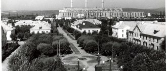
In the early morning of June 22, 1941, Germany treacherously attacked the Soviet Union. Thousands of Soviet people, as well as the people of our region, rose up to defend their Motherland. In the first days of the war, the workers of the region began to rebuild local industry and agriculture on a war footing. In Shchuchye, the PPO (LPM) plant was evacuated from Bryansk. He produced most of his products for export. The war caused many difficulties, but the district party organization and the workers of the region, sparing no effort and time, overcame them together with the whole country. Due to demobilization, the number of working-age population decreased. All responsibility fell on the shoulders of women, youth and old people. Komsomol members made an invaluable contribution to agriculture during the war years. In 1941, Komsomol youth posts for crop protection were created in the region, and two Komsomol youth Sundays were held for the defense fund. Komsomol members organized a warm welcome for the children of evacuated orphanages and boarding schools, prepared premises and everything they needed for them. The status of the city of Shchuchye was assigned on May 16, 1945, when it was decided to transform the Shchuchansky Village Council into a city Council of Workers' Deputies of regional subordination with a population of 10,600 people.
In those days, our city was young, its social development was just beginning: fourteen streets, three kilometers of water pipeline from Lake Peschanoe to the railway station to supply steam locomotives with water. Older people remember using water from wells and lakes. Even a food processing plant took it from Lake Nifanskoe to produce its products. And for a public bathhouse with 25 seats, it was transported on horseback. There were no construction organizations in the city. All work on the construction and repair of cultural and social facilities and landscaping was carried out by the city utilities. It had one GAZ-AA car and horses. There was no department of architecture; land plots were allocated by a city committee inspector. But the city was gradually built and improved: in 1961, asphalting of streets began for the first time. First, a sidewalk appeared around the city garden, then Victory Square was covered with asphalt. A - street residents received water from the constructed water supply system. In 1957, the first electric locomotive came to our city from Chelyabinsk, and in 1975, the railway station and bus station were put into operation. Today our city has become noticeably different! Electric locomotives have long replaced high-speed trains, horses and minibuses.
Date of material creation: 03/26/2014. History of changes