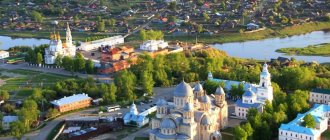
State Lermontov Museum-Reserve "Tarkhany"
State Lermontov Museum-Reserve "Tarkhany"
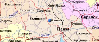
Belinsky district
The Tarkhany Museum-Reserve is located in the family estate of the Arsenyevs, Mikhail Lermontov’s maternal ancestors. The mansion was built by the poet’s grandfather Mikhail Arsenyev in 1794. The estate got its name from the activities of local peasants: they “tarkhanil”, that is, traded.
Lermontov lived in Tarkhany until he was 13 years old. Later, the poet came here to visit his grandmother Elizaveta Arsenyeva. On the estate he wrote the poems “Tambov Treasurer” and “Circassians” and the drama “Two Brothers”.
Lermontov was also buried here - in the family chapel-tomb not far from the mansion. In the same crypt are the graves of his relatives - his grandfather, grandmother and mother.
The museum ensemble includes a manor house, a tomb, two churches, which were built at the expense of Elizaveta Arsenyeva, a gatehouse, a servants' hut, a manor park with ponds and three orchards. The museum has permanent exhibitions “Lermontov in Tarkhany” and “Life of Tarkhany Peasants”. One of them contains a collection of personal belongings of the Arsenyev family, Lermontov’s lifetime publications, his manuscripts and drawings.
In the 2010s, restoration ended in Tarkhany. The museum recreated the life of the Russian nobility in the first half of the 19th century. Nowadays, the estate hosts theatrical performances, master classes on ancient Tarkhan crafts, and costume balls.
State Museum of A.N. Radishcheva
State Museum of A.N. Radishcheva
Kuznetsky district
The museum is located in the restored family estate of the noble Ablyazov family, relatives of the writer and philosopher Alexander Radishchev. The stone manor house was built by the writer’s great-grandfather Grigory Ablyazov. Here Radishchev was born, spent his childhood, and later worked on the economic treatise “Description of My Possession.”
In 1736, the Transfiguration Church was built on the territory of the estate, which has survived to this day. However, the iconostasis was destroyed during the Soviet years. In the late 1990s, another one was moved here from a closed church in a neighboring village. Inside the Transfiguration Church there is a family crypt of the Radishchevs. The writer's parents, brother and youngest son are buried there.
In the 19th century, the mansion fell into disrepair and was demolished. The building was restored on the old foundation in 1995, but its exact appearance could not be repeated. Restorers used drawings and plans of other ancient estates in the Penza region. Inside, the interiors of 19th-century manor houses were reconstructed.
Today, the museum ensemble also includes the former zemstvo school in the village of Verkhnee Ablyazovo. It houses the main exhibition. Personal belongings of Radishchev and members of his family, rare lifetime publications and handwritten copies of “Journey from St. Petersburg to Moscow” are exhibited here.
The purpose of the “expedition” was revealed
Finally, we arrived at the place, on the bank of the Osinka River. In an hour and a half we covered the remaining five kilometers. On the spot I was congratulated on my first ascent. With gratitude and pride for myself and such an untrodden corner of Penza nature, I was ready for new achievements. This is where the purpose of our journey was revealed.
A hundred meters from the river there is a winter hut in the form of a dugout. It was once built by hunters. Time, or rather the weather, destroyed the winter hut - the roof caved in, the boards rotted, and the earth half covered the dugout. The winter quarters require major renovations. It was for these works that Borya Kheifetz lured me, promising to feel the wild thickets and pristine nature with my feet and hands.
And so, armed with shovels, we enthusiastically began to clear the rubble. In total, we transferred six cubes of earth and sand from a depth of three meters and took out a couple of cubes of rotten logs and boards into the fresh air.
Now it is necessary to strengthen the walls and build a roof. For this you need building material. It would seem that there are as many trees around as you like. It would be nice to use oak. But, as Vyacheslav says, “they give a longer sentence for oak.”
Museum-Estate of V.G. Belinsky
Museum-Estate of V.G. Belinsky
Belinsky district
The only Vissarion Belinsky Museum in Russia is located in the city of Belinsky (formerly Chembar). The exhibition is located in a wooden house of the early 19th century, where Belinsky lived from 1816 to 1825. The last time the critic visited here was in 1830. Then he came to Chembar on vacation after finishing his first year at Moscow University. In 1837, the Belinskys sold the house and left Chembar. In the middle of the 19th century, the Antushins merchants set up a tavern in it, which operated until the revolution.
In the 1920s, government offices were located here. The museum in Belinsky’s house was opened in 1938 on the initiative of Chembar local historian Alexander Khramov. Today, household items from the 19th century, books from the family library, and personal belongings of Belinsky’s relatives are displayed here.
The museum complex includes the building of the Chembar district school, where Belinsky studied from 1822 to 1825. The building recreates the interiors of classrooms and presents manuals and textbooks that the future critic used to study. Not far from the school there is a monument “Belinsky the Gymnasium Student”, which was created by sculptor Gennady Malov.
Another permanent exhibition is open in the house of the merchant Fyodor Antyushin, a neighbor of the Belinskys. Manuscripts and letters of the critic, lifetime editions of his articles are exhibited here.
Museum of A.I. Kuprina
Museum of A.I. Kuprina
Narovchatsky district
The Alexander Kuprin Museum is located in the former district town of Narovchat. The wooden one-story house was bought by the writer’s parents, Ivan Kuprin and Lyubov Kulunchakova, in the middle of the 19th century. Alexander Kuprin was born here in 1870.
Some time after the death of her husband, in 1874, Lyubov Kulunchakova sold the house and left with her children for Moscow. The building changed owners several times until it was transferred to the Shlykov merchants. In 1891, the mansion burned down, but the Shlykovs restored it that same year.
After the revolution, the family of the Soviet literary scholar and collector of ancient manuscripts Vladimir Malyshev lived in the Shlykovs’ house. In 1981, the Alexander Kuprin Museum was opened here. Today, the collection contains Kuprin's personal belongings, including photographs, letters, a coffee maker and an ashtray. They were donated to the museum by the writer’s daughter.
Nikolsky Museum of Glass and Crystal
Nikolsky Museum of Glass and Crystal
Nikolsky district
In 1789, at the crystal factory of Alexei Bakhmetev in the city of Nikolskoye, a special storeroom was opened, which was also called the model room. The best products were stored there and then displayed at exhibitions.
In 1884, the plant was inherited by Prince Alexander Obolensky, a distant relative of the Bakhmetevs. The new owner replenished the museum collection with samples of foreign glass. Obolensky also brought to the storeroom decanters found at archaeological excavations in Kerch, which were made in the 1st century AD.
After the revolution, the plant was nationalized and renamed “Red Giant”, and the museum continued its work. His collection included products from Soviet glassmakers. In 1990, a new two-story building was built especially for the museum, which now houses the main exhibition.
Today the museum exhibits one of the largest collections of glass products in Russia, which includes over 14 thousand exhibits. Among them are cups that the factory produced in the 1750s by order of Catherine II, medallions depicting heroes of the Patriotic War of 1812, and a crystal table of Joseph Stalin.
Natural attractions of the Penza region
The Volga region is rich in beautiful places created not by man, but by nature. For example, in the southwest you can visit the Volga Forest-Steppe nature reserve with an area of 8 hectares. A visit can be combined with a tour of the estates and temples located on its territory, as well as go on an excursion telling about the local unique flora and fauna, for example, beaver settlements and plants listed in the Red Book, which the Penza region can still surprise you with.
Attractions, photos of which do not convey the beauty of these places, are scattered throughout the region. Thus, the Ardym Shikhan is a unique natural monument - it is a mountain or hill from which a magnificent view of the surrounding landscapes opens. Legends claim that the Shikhan hides countless treasures hidden in the mound by the Mongol Khan. Perhaps this is true, because excavations at the foot of the mountain allowed archaeologists to find many interesting objects.
Tikhvin Kerensky Monastery in the village of Vadinsk
Tikhvin Kerensky Monastery in the village of Vadinsk...
Penza region
The Tikhvin Kerensky Monastery was founded in 1683 near the city of Kerensk (now the village of Vadinsk). According to legend, at this place the miraculous icon of the Tikhvin Mother of God appeared to the Penza venerable elder Praskovya.
There was a wooden church of the Tikhvin Icon of the Mother of God in the monastery, and in 1762 they began to build a stone one. However, after two years, construction of the temple stopped due to lack of funds. In 1764, the monastery was closed, but the nuns remained to live in it until 1848, when the monastery was reopened.
At the same time, construction of the Church of the Tikhvin Icon of the Mother of God resumed. The building took almost 40 years to construct and was consecrated in 1885. On the territory of the monastery they also built a bell tower with a gate church, and two new churches - the icon of the Mother of God “Life-Giving Spring” and St. Nicholas the Wonderworker.
After the revolution, the monastery was closed again. During Soviet times, its churches lost their domes, most of the fence, and several outbuildings were lost.
In 1997, the monastery was transferred to the Penza diocese. A men's monastery was opened here, and churches damaged during Soviet times were restored. In 1999, the only museum of Orthodoxy in the Penza region was created at the monastery, where church utensils, ancient liturgical vestments and icons are exhibited.
Team Nomads
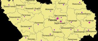
The Penza region was founded in February 1939 on the southeastern part of the European Plain. Most of the region is occupied by the Volga Upland; pine and broad-leaved forests are common in these places, which gradually turn into turf-grass steppes on chernozems. The Penza region has a very diverse fauna, there are more than 300 species of animals: hare, squirrel, fox, badger, etc. About 48 species of fish live in the beautiful reservoirs of the Penza region: catfish, ide, pike perch, bream and many others.
HOLY SPRINGS OF THE PENZA REGION - HERE!
ATTRACTIONS OF THE PENZA REGION - HERE!
ARTICLE ABOUT THE CITY OF PENZA - HERE!
GEOGRAPHY OF THE PENZA REGION - HERE!
RIVERS OF THE PENZA REGION - HERE!
ARTICLES AND LINKS ABOUT THE PENZA REGION - HERE!
TREASURES OF THE PENZA REGION - HERE!
Although not possessing much outstanding architecture, the region is famous for its large number of historical and memorial monuments; there are also many different churches, cathedrals and monasteries in these beautiful places.
NATURE OF THE PENZA REGION Main. part of the territory region is located in the forest-steppe zone. To the north-west and S.-V. it is included in the forest zone, and in the south - in the steppe zone. Means. length: from N. to S. almost 200 km and from W. to E. b. than 300 km, the rather complex structure of the surface determined the differentiation of natural complexes. Vado-Vyshinsky lowland forest district. Located in the north-west. region within the Oka-Don lowland. The relief is dominated by flat plains with absolute heights. 80–180 m, slightly dissected by erosion. Predominant The soils are sandy and sandy loam varieties of soddy-podzolic and gray forest soils with low naturality. fertility. Sum of growing temperatures periods are 2300–2400°. Approximately 50% of the territory. The region is home to pine and birch-pine forests, with spruce in some places. In watershed areas, pine forests alternate with foliage. forests of oak type with the participation of ash and maple.
Verkhnesursky elevated steppe-forest region. Located in the Eastern region, it is characterized by the largest absolute and relative values. heights, deep river valleys, the bottom of which is 120–190 m below the watershed level. In treeless spaces, which occupy more than half of the square. district, that is. gully. In this regard it means. part pl. constitute slopes with a steepness of 8–10. The peaks of the hill are plateau-like or have a hilly-ridge topography. In the depressions between the hills there are moss swamps. Soddy-podzolic sandy soils predominate along the right bank of the river. Sura, as well as gray and light gray forest gravel soils with low natural content. fertility. Sum of growing temperatures period based on parts of the district do not exceed 2200° and, under the influence of relief, fluctuate in meaning. limits. Its duration, like the frost-free period, is 5–10 days shorter than in other regions. OK. 40% of the district is occupied by broad leaves. forests of oak and linden with a large proportion of small leaves. breeds
Sursko-Mokshinsky forest-steppe district. Occupies zap. half of the region, except for the bass. Khopra in the south of the extreme north-west. Its border in the east is the river. Sura and below river flow Bonds. The relief is hilly, with large slopes. heights, although several. less than on the right-hand side. R. Surahs. River valleys and gullies cut deeply, at 90–120 m, into the surface, elevated to 270–290 m. The slopes of the valleys and gullies are densely dotted with ravines. The gully-gully network exceeds 0.4 km/km2. Soil the cover is presented in the main leached chernozems. In the north-east parts to the left bank of the river In Sura there are massifs of slightly leached rich and medium-humus chernozems with high fertility. Sum of temperatures during the growing season. period on b. h. district 2300–2400°. Humidification is below optimal. Treeless areas predominate. The forests are of an island nature and are located on watersheds and riverine slopes. They are presented preem. oak forests in combination with birch forests, birch-linden forests and aspen forests. The meadow-steppe cover was preserved only along the ravines and slopes. Kadadino-Uzinsky elevated forest-steppe region. Located in the south-east. region, has a hilly outcrop relief. Means. relative heights reaching 100–150 m, complex terrain determine the creatures. differences in the provision of heat, degree of moisture, and the nature of the soil. and growth cover. The Uza River divides the district into two parts: the elevated eastern part. and relatively flat west. Soil The cover is represented by varieties of chernozem soils. On watersheds there are tracts of gray forest soils. Sum of growing temperatures The period varies from 2200 at higher elevations to 2400° at low elevations. Hydrothermal the coefficient ranges from 0.9 to 1.1. The distribution of forests is insular, with a predominance of oak forests; steppe grass pine forests are also found. On the remaining slope and upland areas of the meadow steppe, forb-fescue and forb-rhizomatous-grass associations are widespread. Vorono-Khopersky steppe district. Occupies the south-west. areas. The surface is softly ridged, with a general slope to the south-west. Soil The cover is represented by typical rich and slightly leached chernozem soils with high natural properties. fertility. Sum of growing temperatures period is about 2500°. On the territory areas max. arid region Hydrothermal the coefficient is everywhere below 0.9. Forest cover is very small (8%). Along the slopes and ravine areas there are forb-fescue and fescue-feather grass associations.
SOURCE OF THE SUR RIVER
The sources of the Sura River are the Sursky Peaks. Baryshsky district, Ulyanovsk region. Latitude: 53°23′1″N (53.383667). Longitude: 46°56′18″E (46.938375). The Sura River - or, as it is also called, the “younger sister” of the Volga - the second largest right tributary of the most famous water artery in Russia, originates in the Ulyanovsk region, in a village with the provocative name Surskie Vershiny. It is from here, from a small stream (according to the official version), that the main river of the Sursky region - the Penza region - begins its long, 841-kilometer journey to the mouth. And also one of the most significant rivers of the republics of Mordovia, Chuvashia and Mari-El, Ulyanovsk and Nizhny Novgorod regions. Therefore, it was from the Sur Peaks, from the sources and further, across fifty bridges located along the entire course of the Sura, that our mini-expedition began, called “Sur Bridges. From source to mouth." During which, we, the four participants in this trip - Vladislav, Anatoly, Daniil and I, not only got acquainted with all the structures anywhere connecting the two banks of the Sura, but also once again became convinced that the river that gave the name to Sursky region is indeed interesting, changeable, varied in texture, but most importantly, of course, very, very beautiful. Especially in the crimson colors of early autumn.
where it is, how to get there: The village of Surskie Vershiny in the Baryshsky district of the Ulyanovsk region is the place where the Sura begins, has the status of the official sources of the river, on the one hand justified, on the other hand - perhaps not. So, it is now impossible to determine 100% accurately from which specific spring our favorite waterway originates. Moreover, in the village itself there are at least two reservoirs dammed by dams, which with a certain degree of certainty can claim to be the Sura sources (or, more precisely, “nadistoks”). But, according to archival data, the springs that merged together and once gave rise to Sura were, in general, not in the Sura Heights, but somewhat higher than the village, in the forest. But the forest was cut down, the streams were blocked with a dam, the springs were silted up and now the sources of the Sura are marked where they are marked.
Vegetation of the Penza region Vegetation is a naturally formed, environmentally determined, relatively stable set of plant communities: forest, meadow, steppe, etc. Penza. The region is located in the forest-steppe zone, in the right bank part of Sr. Volga region and partly in the upper reaches of the Khopr and its tributaries (Don basin). On the territory Penz. region in the main Meadow-steppe and broad-leaved forest types of vegetation predominate. cover. The forests cover an area of approx. 20%, b. h. to the north-east. regions in Kuzn., Sosnovobor., Nikolsk., Gorodishche., Lunin. district They occupy a significantly smaller area in the north-west. - in Zemetch. and Moksh. district In the southern region, the distribution of forests is island-like, usually accompanying the valleys of the Kadada, Uza, Khopra, Vorona, and other rivers. forest-forming species: summer oak, small-leaved linden with the participation of sycamore maple (maple-linden oak forests). In a few cases, ash oak forests have been preserved. Smooth elm and rough elm are found in oak forests. In zap. districts (Belinsk., Pachelm., Zemetch.) in oak forests you can rarely find field maple; the eastern route passes here. the boundary of its distribution area. On the north-east areas in the river basin Surahs along with oak. relatively large areas are occupied by different types of pine and broad-leaved pine forests. Of these, most grassy birch-pine forests are common. As a rule, the distribution of complex pine forests (with a second layer of linden and oak) is associated with watersheds. Along the tops of sandy hills and their southern slopes, lichen-green moss pine forests (with a ground cover of green mosses) are common, confined to the north. slopes of hilly sands and inter-hill depressions. Blueberry pine forests are rare. Small areas of pine forests in the southwest, in the river basin. Khopra and in the north-west. in the river basin Moksha. Locations of spruce and common juniper are very rare. Aspen and two types of birch (downy and silver) are common throughout the forests. Through the swamps On the bottoms of ravines, ravines, and floodplains, alder forests with the participation of willow, black grass, other woody trees, and many others are quite common. shrubby species of willow, often forming continuous thickets (thickets) (see Forest). Meadows with a predominance of rhizomatous grasses and a large participation of other perennial grasses occupy a relatively small area (about 10%). Plowing of land has significantly replaced the meadow agriculture of the region. But, as in the past, most. common grows. communities with the dominance of moderately moisture-loving cereal plants, in particular bluegrass, fescue, queen grass, timothy, foxtail, etc., as well as many other species. other families of the so-called meadow herbs. In damp and swampy areas, soddy-pike, sedge and other types of communities predominate. On b. high levels, so less soil moisture; steppe mixed-grass meadows are common. The swamp-water river occupies an area of approximately 200 m. 0.5% (see Vegetation of swamps; Aquatic and coastal vegetation). Especially rare to grow. landscapes of raised and transitional moss bogs. Steppe agriculture in the region, as well as in the entire European part of Russia, has been reduced to extreme limits in the current century. The plowed area of steppe chernozem soils is now no less than 64%. Fragments (“splinters”) of steppe rivers on watersheds with an area of 200–250 hectares in Penza. region can be seen only in three sections of the Volga Forest-Steppe Nature Reserve in Penza, Kolysh. and Neverk. district In some places, areas have been preserved on the slopes of ravines and gullies, along the south. slopes of the indigenous banks of river valleys, on the tops of hills with rocky soils, sometimes on forest edges. Under these conditions, it is still possible to observe a set of communities with the dominance or large participation of feather grass species (narrow-leaved, pinnate, pubescent-leaved, hairy grass, or Tyrsa), fescue, sheep, brome grass, thin-legged grass, other steppe and meadow-steppe grasses, as well as rich, colorful blooming steppe herbs. Among the shrubs, Russian broom, low almond, steppe cherry, gorse, crenate spirea, and prickly thorn are widespread. Among the steppe flora there are rare species not only for Penza. region, but also for the whole Wed. Volga region and certain other adjacent territories. Among them are desert sheep, gray teresken, ephedra bispica, pubescent kermek, minuartia bristles, some astragalus, sage, etc. (see Steppe grasses; Steppe shrubs).
SURA RIVER
Sura (Chuvash. Săr, mountain mar. Shur, erz. Sura lei) is a right tributary of the Volga , one of the most picturesque rivers of the Volga Upland.
It should be assumed that the Kama tribes, having come to Sura, could have found here the ancient Mordovian name - rau (river), the meaning of which they did not know. Living on the shores of Sur for several hundred years, the newcomers added the native word Shur to the name Rau. The result was a hybrid name Shur + Rau. Then Prisurye again became the patrimony of the ancient Mordovians. As a result, the hydronym could be pronounced Surau, the final “a” arose under the influence of the Russian word for “river”.
It flows through the Ulyanovsk, Nizhny Novgorod and Penza regions, Mordovia, Mari El and Chuvashia.
The length of the river is 841 km, the basin area is 67.5 thousand km².
It originates on the Volga Upland near the village of Surskie Vershiny (Baryshsky district of the Ulyanovsk region - Height 301 m), and flows along it first to the west, then mainly to the north.
SURA RIVER
SURA RIVER
The Volga Upland is a hill on the right bank of the Volga from Nizhny Novgorod to Volgograd. Height up to 384 m. Predominant height 150-200 m. Width up to 500 km. The Volga Upland steeply, in places with ledges, breaks off towards the Volga and gently declines towards the Oka-Don lowland. It is strongly dissected by a gully-beam network. Individual parts of the high Volga slope are called mountains. The Volga Upland is characterized by the presence of tectonic swells and troughs that cause the development of structural forms of relief. It is composed of limestones, clays, sands, marls and other rocks. Karst is developed.
The highest mountains in the Volga Upland: Khvalynsky Mountains.
The glacier touched only the westernmost edge of the Volga Upland. Therefore, sedimentary rocks here are not covered by thicknesses of glacial deposits and more often protrude to the surface. These are limestones, chalk, sandstones.
In the lower reaches of the Sura, it is raftable and navigable.
Used for industrial water supply.
SPRING OF ELDER LEONTIUS
On the border of the Ulyanovsk and Penza regions in the village of Krasnaya Polyana, ten meters from the destroyed church, there is an amazing Holy Spring, called by local residents as the Holy Spring of Elder Leontius. Despite the remoteness of this place, the flow of pilgrims to this source still does not dry up.
This spring became famous thanks to Elder Leonty, rector of the St. Nicholas Church. The history of this revered source is as follows. Once upon a time, an Athonite elder, schemamonk Leonty, came to the village of Synodskoye, as the village of Krasnaya Polyana was previously called. He brought with him several icons of the Athonite script, some of them have been preserved and are in the Holy Trinity Church in the city of Barysh. The elder built a small wooden cell on the outskirts of the village, near a spring, and began to live quietly and modestly. They say that he was kind and affectionate, especially towards children.
One local grandmother, Valentina Malova, whose grandfather served as a cell attendant for the elder Leonty, who was already the rector of the St. Nicholas Church, said that the elder himself was like a child - quiet, kind, affectionate and friendly. He was of a very gentle disposition and was distinguished by boundless kindness, he especially loved children, always spoke kindly to them and discreetly put sweets in their pockets.
Even during his lifetime, sick and disabled people were brought to the elder and received healing.
Specially protected natural areas (SPNA) of the Penza region According to the Federal Law, their following categories are approved: state. natural reserves where household activities are completely prohibited. activity; national parks where regulated tourism is allowed; natural parks created for environmental and recreational purposes. purposes; sanctuaries - territories intended for the protection and restoration of natural complexes where economic management is temporarily limited. activity; natural monuments, unique and irreplaceable natural complexes and objects; dendrological parks and botanical gardens; healing and healing. areas and resorts. Protected areas can be of federal, regional and local significance. Among the latter, in addition to those listed, other protected areas may be established by decisions of local authorities: green zones, mountains. forests and parks, landscapes, etc. objects, etc. On the territory. The region has a number of the above-listed protected areas. State Nature Reserve “Volga Forest-Steppe” It consists of 5 separate sections: 1. “Upper reaches of the river. Sura", occupies sq. 6339 hectares, is represented by a large tract of Scots pine aged 120–150 years and mixed forest cenoses, as well as biol. species (common juniper, blueberry, lingonberry). It has scientific, recreational and water conservation significance. 2. “Borok”, occupies sq. 399 hectares, located in the southwest. slope of the river watershed Kadada, a beautiful forest of pine of different ages and an undergrowth of hazel, elderberry and rowan. A special place in the reserve is occupied by 3 steppe areas. 3. Kuncherovskaya forest-steppe, pl. 997 hectares The area of open steppe is surrounded by forest communities, with a predominance of birch forests and the participation of oak and pine aged 100–120 years. The peculiarity of the steppe is the presence of plants. associations related to real steppes, as well as a rare relict species in the Volga steppes - desert sheep. 4. Ostrovtsovskaya forest-steppe, or “Wild Garden”, pl. 352 hectares. Characterized by a large species diversity of herbaceous plants; In the vegetation structure, steppe cherry, bean, rose hips, and common viburnum are rare for the region. Grows. cenoses have a multi-tier structure. In the upper tier, together with shrubs, there are large grasses: fescue, feather grass and feather-leaved feather grass, coastal brome, intermediate wheatgrass, desert sheep. In the lower tier there are different types of wormwood: bitter, Pontic, broad-leaved, Armenian, Austrian, common and types of clover: meadow, alpine, middle. 5. The Poperechenskaya steppe is located on a high plateau, between the river. Khoper and its tributary river. Archadoy, pl. 252 hectares. In the northern or meadow area, turf grasses dominate: fescue or furrowed fescue, awnless brome. To the south slopes and b. in dry places feathery feather grass is found, according to b. moistened - tonkonogo, meadow bluegrass and dog bentgrass, as well as low almond or bean shrub. The moss-lichen cover is dominated by thuidium moss. The abundance of cereals is complemented by a wide variety of dicotyledonous grasses. There are only b. 360 species. In the reserve, 7 rare species listed in the Red Book are noted: feather feather grass, feather feather grass, Zalessky feather grass, Russian hazel grouse, Neottiantha capulata, red pollenhead and a mushroom from the group of macromycetes - fly agaric cone-shaped. (See Privolzhskaya Forest-Steppe Nature Reserve.)
MOKSHA RIVER
____________upper reaches of the Moksha River, Penza region
Tributaries: right - Sivin, Satis, Ermish; left - Vad, Tsna. Cities: Temnikov, Krasnoslobodsk.
On the river Moksha is the Nativity of the Mother of God Sanaksar Monastery.
Origin of the name The name was left by the ancient Indo-European population of Poochya, who spoke a language close to the Baltic. The hydronym is comparable to the Indo-European stem meksha, meaning “shedding, flowing away.” It is believed that in the language of the Indo-European aborigines, moksha meant “stream, current, river” and as a term was included in a number of hydronyms (rivers Shirmoksha, Mamoksha, etc.).
State natural reserves (zoological) As of June 1, 2000, 15 of them were allocated in a total area.
106.6 thousand hectares. They are organized for the conservation and restoration of animals and birds. Natural monuments As of June 1, 2000, 51 were approved, including: botanical - 38 on the total area. 4756.1 hectares, water - 13 on the total area. 167.2 hectares. These are separate biological objects that are important for science, education, culture, nature conservation, for instilling respect for nature. Botanical natural monuments. Among them: massifs and groves, geographical. cultures and memorial plantings, phenomenal and exotic trees. plants. Forests and groves (16 objects). The greatest interest as genetic. The reserves are represented by the Salovsky pine forest, the Akhunsky pine forest - 273 hectares, the Arbekovsky forest (oak grove) - 281 hectares, the Bolshevyassky forest (pine) - 605 hectares, the Melnichny forest - 192 hectares. Geographical cultures and memorial plantings (5 objects) are located in the districts of the region and occupy the area. 206.4 hectares. The following monuments are of interest: Geographical larch cultures, Memorial cedar plantings, Weymouth pine cultures, etc. Water natural monuments. Represented by lakes and ponds, springs and swamps. 6 lakes located in Belinsk, Gorodishche, Lunin, Nikolsk have the status of a natural monument. districts, their water surface area is 97.0 hectares. 5 springs with a total area of \u200b\u200bare designated as natural monuments. 0.4 ha. The most famous are: “Klyuchevsky spring” (village Zasechnoye), “Life-giving spring” (village Valyaevka), spring “Chasovnya” (Kuznetsk), spring “Zhivoy” (state farm “Poimsky” Belinsk district), “Bolshoi spring" (Leninsky forestry enterprise). KHOPER RIVER
Khoper is a large river in the Penza, Saratov, Voronezh and Volgograd regions of Russia, the largest left tributary of the Don. Length 980 km, basin area 61,100 km². The food is predominantly snowy. High water in April - May. The highest water flow is 3720 m³/s, the lowest during low water is 45.4 m³/s, the average water flow is 150 m³/s. It freezes in December and opens in late March - early April. In some years, ice cover is unstable. Width up to 100 m, depth up to 17 m. The bottom is usually sandy; The current is fast. There are many oxbow lakes in the Khopra Valley.
There are many species of fish in the river: pike perch, ide, sabrefish, catfish, pike, perch, bream, crucian carp, asp, chub and others. Sterlet, burbot, tench, carp, gudgeons, etc. are rarely found.
There are moose, hares, gray herons, swans, eagles, falcons, owls, nightingales, ducks, beavers, river turtles, snakes (snakes and vipers), etc. near the river. The unique nature has made Khopyor a favorite place for tourists.
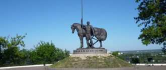
Old man Khoper. Source of Khopra. Legendary mill
According to legend, old man Khoper lived in these places. He was walking along the steppe and saw 12 springs coming out of the ground. The old man took a shovel and connected all these springs into one large stream, on which he built a mill and ground grain here for peasants from the surrounding villages. And the river was then given the name of its creator. At the source of the Khoper River near the village of Kuchki, Penza District, Penza Region, a monument “Old Man-Khoper” by sculptor Andrei Smely was erected. The Khoper originates in the central part of the Penza region, within the Volga Upland, flows through elevated terrain in a southwestern direction, and flows into the Don near the village of Ust-Khopyorskaya.
Khopyor is navigable (from the city of Novokhopyorsk, 323 km from the mouth). Motor ships "Comets", ferries, and barges sail along the Khopr River. A pontoon bridge was installed in the village of Fedoseevskaya from 1955-1957. Since the late nineties, due to the construction of bridges, shipping has been cancelled. Along the entire route of the river, bridges reach a height of 18-26 meters. A significant part of its length is accessible for kayaking. On the river are the cities of Balashov, Povorino, Borisoglebsk, Novokhopyorsk, Arkadak, Uryupinsk. The Khopra Valley was one of the places where the Don Cossacks settled. The Khoper River became widely known in Russia thanks to its scandalous reputation for defrauding investors by building a financial pyramid.
In the Khopra Valley, back in the middle of the 20th century, reserves with rich flora and fauna were organized - Almazovsky, Khopersky, Arkadaksky. In these reserves the following animals are protected: fox, river beaver, muskrat, wild boar, brown hare. In the lower reaches of the river, in the area between the cities of Borisoglebsk and Novokhopyorsk, there is the Khopyorsky Nature Reserve.
Dendrological parks and botanical gardens There are 4 of them on the square. 182.5 hectares: Akhunsky dendrological park – 17.0 hectares; arboretum in the village Sura – 2.5 hectares; Arboretum site of the Barabanovsky forestry of the Lomovsky forestry enterprise - 3.0 hectares; arboretum of the forestry named after. prof. G. F. Morozova - 14.3 hectares. They were created for educational and aesthetic purposes, cultural recreation of the population, and the cultivation of interzonal species of trees and shrubs. Medical and health-improving areas and resorts 1. Resort areas, including plantings around sanatoriums, holiday homes and pioneer camps, 8 thousand hectares. 2. Sanitary protection zones (sanitary protection zones of water supply sources and mineral water deposits) around the sanatoriums of the Republic. and local values – pl. 6.7 thousand hectares (see “Chistye Prudy”). 3. Recreational or leisure areas. This includes forested areas and mountains. forests - total area 42.2 thousand hectares.
Other protected areas 1. Monuments of landscape art, there are 4 of them on the square. 97.0 hectares, they are of interest as objects of architectural and park art, they have scientific, historical and educational environmental significance. Ancient parks are of particular interest and value: Golitsynsky Forest Park - 18.0 hectares; Zubrilovsky Park – 7.0 hectares; Kurakinsky Park - 30.0 hectares (see Nadezhdinskaya Estate); Belokamenskoye forest park – 42.0 hectares. There are about 100 species of trees and shrubs, 30 of which were imported from Europe, Asia and America (Weymouth and black pine, Siberian cedar, Siberian fir, Amur velvet, Manchurian walnut, large-leaved linden, silver poplar and many others). 2. City parks. This includes all parks located in the territory. cities of Penza. region Their total area is approx. 5 thousand hectares. Naib. famous: park of culture and recreation named after. V. G. Belinsky, Arbekovsky Park, located in P.
3. Particularly valuable productive lands with a total area of \u200b\u200bare allocated. 120 hectares, including: arable land - 105.5 hectares, hayfields - 2.2 hectares and pastures - 12.3 hectares.
ISSA RIVER
Issa is a river in the Penza region and the Republic of Mordovia of Russia, the right tributary of the Moksha (Volga basin). The length of the river is 149 km (of which in the territory of Mordovia - 98 km), the basin area is 2350 km² (in the territory of Mordovia - 1790 km²).
The width of the channel in the lower reaches of the river is up to 50 m, the average depth is 1-1.5 m.
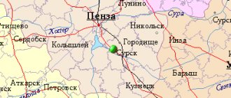
Issa originates from the village of Bereznikovsky, Luninsky district, Penza region. The largest settlements on the river are the city of Insar and the urban-type settlement of Issa.
Issa River near the village. Paevo
Issa river in summer
The Issa has 3 small tributaries (Seitma, Insarka and Potizh) and 30 very small tributaries. The total length of the Issa river network with all its constant tributaries is 480 km.
Tributaries (km from the mouth] 19 km: Seitma (Selma) River 44 km: Tarsa River 68 km: Shishkov Stream 71 km: Paska Stream 78 km: Insarka River 85 km: Vyazera Stream 90.7 km: Bolshoy Stream 91 km: River Stsevka 98 km: Potizh River (Prorva, Potish, Portizh) 105 km: Shishov River 114 km: Sukhoi Shirokois River 128 km: Kostylyayka River.
CROW RIVER
The Vorona is a middle river in the Penza, Tambov and Voronezh regions of Russia, the right tributary of the Khoper River (Don basin). Along the entire river there are many natural monuments, a beaver reserve, beautiful cliffs, sandy beaches, relict oak forests. Length - 454 km, basin area - 13,200 km². The river is very popular for boating and fishing! The source of the river is springs on the Kerensko-Chembarskaya Upland (north of the village of Vedenyapino, Pachelma district, Penza region). The right bank is low, the left bank is high. There are deciduous forests and many lakes in the river valley.
CROW river
The river is fed by snow. The average annual flow rate at the mouth is 41.5 m³/sec. Freeze-up from early December to early April. The maximum depth of the river is 4 m.
LIST OF NATURAL MONUMENTS As of 06/01/2000, 51 were approved, including: botanical - 38 on a total area of 4756.1 hectares, aquatic - 13 on a total area of 167.2 hectares. These are individual biological objects that are important for science, education, culture, nature conservation, and for instilling a caring attitude towards nature.
1) Botanical natural monuments, 2) Geographical cultures and memorial plantings.
Among them: massifs and groves, geographical cultures and memorable plantings, phenomenal trees and exotic plants. Bekovsky district: -Khopersky pine forest. Bekovskoe forestry, 72.0 hectares.
Belinsky district: -Shugai tract. Svishchevskoe forestry, 18.9 hectares.
Bessonovsky district: -Geographical pine crops
Vadinsky district: -Kuvshinovsky forest. Verkhnelomovskoye forestry, 77.0 ha
Gorodishchensky district: -Melnichny Bor. Chaadaevskoe forestry, 192.0 hectares. -Salovsky pine forest. Chaadaevskoe forestry, 535.0 ha. - Nikolsky Bor. Krasnooktyabrskoye forestry, 1010.0 hectares. - "Ravine of Death." Pavlo-Kurakinskoe forestry, 2.5 hectares.
Zemetchinsky district: -Weymouth pine crops. Morsovskoe forestry, 0.8 hectares. - Obolensky Garden. Saltykovo village, Saltykovskoye forestry, 19.0 hectares. -Memorable cedar plantings. Saltykovskoe forestry, 17.0 hectares.
Luninsky district: -Bolshevyassky forest (pine). Bolshevyasskoe forestry, 609 hectares. -Geographical cultures of pine. Ivanyrsensky forestry, 97.0 hectares. -Pine crops on an eroded slope. Lomovskoye forestry, 81.0 hectares. -Lomovsky moss swamps. Lomovskoye forestry, 39.8 hectares.
Maloserdobinsky district: -Klyuchevoy Bor. Danilovskoye forestry, 239.0 hectares.
Mokshansky district: -Steppe “Bolshaya Endova”. Educational and experimental farm of Perm State Agricultural Academy, 50.0 hectares.
Nizhnelomovsky district: -Cave of bats. Golovinschenskoye forestry, 3.0 hectares.
Nikolsky district: -Giant oak. Ilmensky forestry, 1.0 ha. -Pestrovsky forest area. Pestrovskoe forestry, 7.3 hectares.
Penza: -Akhunsky pine forest. Zasursky forestry, 273 hectares. -Square of the Museum of Folk Art. St. Kuibysheva, 47; 0.4 ha.
Penza district: -Arbekovsky forest (oak grove). Ramzai forestry, 281 hectares. -Ardym Shikhan. Right bank of the river Ardym, 4.0 ha. -Geographical cultures of larch. Zasursky forestry, 10.0 hectares. -Elena steppes. GPP "Elansky" and state farm "Konstantinovsky", 237.8 hectares. -Zarechensky forest. Zarechensky Gorleskhoz, 80.0 ha. -Zasursky bor-blueberry. Zasursky forestry, 13.8 hectares. -Zolotarevsky pine forest -Olshansky slopes. North of the village. Olshanka, 30.0 ha. -Plantations of serviceberry and black hawthorn. Zasursky forestry, 1.6 hectares. -Prisur oak grove. Zasursky forestry, 357.0 hectares. -Giant pines. Zasursky forestry, 2.0 hectares. -Shnaevskaya ash oak grove. Urban settlement Zolotarevka, 100.0 ha.
Sosnovoborsky district: -Bor-belomoshnik. Inderskoe forestry, 12.0 hectares. -Double oak. Markinskoye forestry, 0.1 ha. -Cedar Grove. Forest garden forestry, 0.42 hectares.
Shemysheysky district: -Krasny Maar. Kolkhoz named after Michurina, 34.0 ha.
3) Water natural monuments.
Represented by lakes, ponds, springs and swamps. Belinsky district: -Lake “Chkalovskoye”. Morozovskoye forestry, block 94, 12.0 hectares. -Spring “Alive”. State farm "Poimsky", 0.1 hectares.
Gorodishchensky district: -Lake “Borovoye”. Chaadaevskoe forestry, 0.2 ha. -Lake “Bolshoye Mokhovoe”. Chaadaevskoye forestry, 14.0 hectares. -Lake “Tsarkovskoe”. Village of Srednyaya Eluzan, 50.5 hectares.
Kuznetsk district: -Cranberry swamp. Chibirley forestry, 21.0 hectares. - Nikolskoe swamp. Collective farm "Path to Communism", 48.8 hectares. -Spring “Chapel”. Kuznetsk, 0.08 hectares.
Luninsky district: -Lesnye lakes. Vazersky forestry, 5.2 hectares.
Mokshansky district: - “Chistye Prudy”
Nikolsky district: -Lake “Shevokal”. Bolshevyasskoye forestry, 3.7 hectares.
Penza district: -Bolshoy spring. Leninsky forestry enterprise, 0.02 ha. -Life-giving spring. S. Valyaevka, 0.1 ha. -Klyuchevsky spring. S Zasechnoe, 0.1 ha.
INZA RIVER
Inza is a river in the Ulyanovsk and Penza regions, the right tributary of the Sura River (Volga basin). The name of the Inza River supposedly comes from the Mordovian-Erzya “inzeen” - “raspberry”. The river originates in the Ulyanovsk region in the Bazarnosyzgan and Inzensky districts, flows in the Nikolsky district of the Penza region, the right tributary of the Sura, flows near the village of Sura.
ARTICLE ABOUT THE SUR RIVER
The source of the Inza River is located in the village of Voronovka, Bazarnosyzgan district, flows from an ordinary spring and flows at the bottom of a ravine, filling with groundwater and rainwater.
It has tributaries: left - Ramaleika, Perepeleika; right - Papuza, Embeleika, Syzganka.
Characteristics Length 103 km Water system Sura → Volga → Caspian Sea
WATER COURSE INZY Istok Volga Upland • Location village. Voronovka (Bazarnosyzgansky district of the Ulyanovsk region) • Height 240 m Ustye Sura • Location of the village of Sura (Nikolsky district of the Penza region) • Height 116 m • Coordinates: 53°54′11″ s. w. 45°43′52″ E. d. (G) (O) (I) River slope 1.2 m/km
RIVER VYSHA
Vysha (Noksa) is a river in the Penza region, Mordovia and Ryazan region of Russia, the right tributary of the Tsna (Volga basin). Pool of Moksha. Length - 179 km, basin area - 4570 km². Powered by snow and rain.
Freeze-up usually occurs from November to April.
The sources of the river are in the Penza region.
Flows through the regional center of Zemetchino. The administrative border of the Penza region with Mordovia runs along the river for 15 km, on the territory of which the village of Vysha is located (3 km from the river). It flows into the Tsna on the territory of the Ryazan region. At the confluence is the village of Vysha, Shatsk district, Ryazan region, famous for the Holy Dormition Vyshinsky Monastery.
Tributaries (from the mouth): right - Izvest (3.5 km), Purlya (24 km), Shuvarka (53 km), Ushinka (147 km); left - Kermis (23 km), Pochkar (72 km), Torcha (84 km), Sych (87 km), Raevka (94 km), Mashnya (107 km), Noksa (147 km); further r. Noksa Burtas (148 km), Olshanka (155 km).
—————————————————————————————————————————————————— —————————————- SOURCE OF INFORMATION AND PHOTO: Team Nomadic Ryabov A.M. Specially protected natural areas / Penza Encyclopedia. M.: Scientific publishing house "Big Russian Encyclopedia", 2001, p. 421-422. Penza Encyclopedia. M.: Scientific publishing house "Big Russian Encyclopedia", 2001, Appendix 14. Specially protected natural areas of the Penza region as of June 1, 2000, p. 713-714. https://www.penzaobl.ru Natural monuments of the Penza region Antonov (1, 2, 4); With love for nature; Problems of protecting Russia's biodiversity: Materials of All-Russia. conf. September 24–26, 1996. P., 1996; Scientific and practical conference “Ecological problems of agriculture”. June 20–21, 1996. P., 1996. A. M. Ryabov. Specially protected natural areas / Penza Encyclopedia. M.: Scientific publishing house "Big Russian Encyclopedia", 2001. https://www.geografia.ru/penza.html Gladkov N.A., Mikheev A.V., Galushin I.M. 1975. Nature conservation. Textbook manual for students of biology. specialties ped. Inst. M., Enlightenment. 299 pp. Pocket book of a naturalist and local historian. M., Geographgiz, 1961, 264 p. Classics of local history. Anthology. Ed. P.S. Kabytova, E.L. Dubman.