TOP 5 most interesting places in the Astrakhan region
A journey through the Astrakhan region will be especially vivid and memorable if you start it from the coast of the Caspian Sea, the biosphere reserve and the main treasures of the Bogdinsko-Baskunchaksky Nature Reserve - Mount Bolshoye Bogdo and Lake Baskunchak. Along the way, tourists should visit the artificial city of Saray-Batu, one of the most spectacular attractions created by human hands.
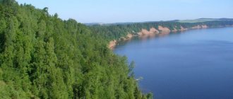
Caspian Sea
- Coordinates on the map: 45.627749, 48.986745.
In the southeast, the Astrakhan region borders the largest lake in the world, which is called the sea due to its incredible size. The Caspian Sea is in many ways inferior to the Black Sea resorts, but they are also popular among vacationers.
The shore of the Caspian Sea is covered with coarse golden sand; in the summer the water warms up to 26 °C. Several recreation centers have been built on the coast, which operate all year round and offer tourists all the conditions for passive and active recreation.
Astrakhan Biosphere Reserve
- Address: Kamyzyaksky district, Damchik village.
The region's most extensive reserve was founded in April 1919, but received the status of a natural site of national importance only in November 1927. The natural reserve with an area of almost 68,000 hectares covers the territories of three districts:
- Ikryaninsky,
- Kamyzyaksky,
- Volodarsky.
The protected area is home to 17 species of mammals and 280 species of birds, including the endangered little cormorants, Egyptian herons, Dalmatian pelicans and the rare white cranes. Dozens of fish species live in rivers and reservoirs: sturgeon, stellate sturgeon, carp, chub, herring, beluga, bream, asp, pike perch, pike and many others.
The value of Astrakhan nature is recognized internationally; in 1984, the reserve was included in the World Network of Biosphere Reserves.
Mount Big Bogdo
- GPS coordinates: 48.144200, 46.856681.
The indescribably beautiful mountain Big Bogdo is the heart of the Astrakhan region. The amazing peak is actually a large hill, but its 150-meter height makes it the highest point of the entire Caspian lowland. The name of the mountain comes from the Kalmyk “Bogdo-uul”, which translated into Russian means “holy”. The slopes of the hill are dotted with numerous caves, grottoes, and funnels.
Scientists first became interested in the peak in 1769. In 1926, the mountain was explored by the future science fiction writer Ivan Efremov. The expedition of the 19-year-old boy subsequently formed the basis of his story “White Horn”.
Big Bogdo is the edge of the so-called salt dome. Since the dome continues to protrude outward, the mountain grows along with it: every year its height increases by about one millimeter. The Red Slopes are the only place in the country where the squeaky gecko lives. Kalmyk Buddhists consider the hill a sacred place and periodically make pilgrimages to it.
Lake Baskunchak
- Coordinates: 48.201701, 46.887530.
At the foot of the Big Bogdo lies the most famous and largest salt lake in the region - Baskunchak, which means “sunny” in Turkic. The reservoir is located on the top of a salt mountain, extending several kilometers deep into the earth. Baskunchak itself is quite shallow, its maximum depth is 3 meters.
The length of the reservoir is 18 kilometers, width - 13 kilometers. Only one river flows into the lake with the telling name Gorkaya Rechka. The only river, which also partially dries up, is not capable of replenishing the lake with water alone; it is mainly fed by 25 springs located on the northwestern bank of Baskunchak.
Salt has been mined on the reservoir since the 8th century. In the Middle Ages, amazingly pure salt was in demand not only in Rus', but also in overseas countries; the valuable product was sent for sale along the famous Silk Road. The concentration of salts in the lake is so high that the water easily holds the bodies of people and objects on the surface.
In Soviet times, racing cars were even held here to set speed records. Nowadays, the lake produces 80% of all salt mined in Russia. The reservoir is also famous for its healing brine and deposits of medicinal clays. In the summer, tourists from all over the country come to Baskunchak; vacationers take mud baths and swim in salt water.
Saray-Batu
- Coordinates: 47.238519, 47.373263.
The eyes of travelers heading to Astrakhan through the village of Tambovka are presented with an unexpected picture that can easily be mistaken for a desert mirage. In the middle of the steppe and sand dunes, an ancient settlement with adobe houses grows.
The eastern city is not a historical monument at all, but a large-scale set for the film “The Horde,” filmed in 2011. The filmmakers' creation recreates the disappeared Golden Horde capital of Sarai-Batu. After filming ended, the scenery turned into an open-air museum and a new landmark of the Astrakhan region.
Astrakhan nature reserves and sanctuaries
Astrakhan nature is diverse and priceless, therefore, various landscape, botanical, zoological and complex reserves were created to protect it.
Bogdinsko-Baskunchaksky Nature Reserve
- Coordinates: 48.197646, 46.982264.
The second nature reserve of the Astrakhan region was organized in the vicinity of the Bolshoye Bogdo mountain-hill and the unique salt lake Baskunchak. In 1993, a reserve of the same name with an area of 53,700 hectares was created on the border with Kazakhstan. Later, in 1997, a state nature reserve was established on a plot of land covering more than 18,000 hectares.
In addition to the mountain and the lake, the young reserve included karst fields, the Sharbulak tract, the Green Garden oasis of forest vegetation, as well as numerous caves and sinkholes.
The flora and fauna of the protected area is diverse and incredibly valuable from a scientific point of view; many species of birds, mammals and plants are listed in the Russian Red Book and the International Red Book. Some specimens are endemic, meaning they live in only one place on the planet.
Ilmenno-Bugrovoy reserve
- Coordinates: 46.183333, 47.600000.
A large reserve was founded in 1995 on the lands of the Narimanovsky and Ikryaninsky districts. The area of the protected area is 6,700 hectares. A unique feature of the local landscape is the Baer mounds, whose length reaches 20 kilometers and width - 800 meters.
Huge sandy-clayey hills gave the reserve part of its name - “Bugrovoy”. The first part of the name, “Ilmenno”, comes from the numerous ilmens - salt and freshwater lakes.
The main goal of the reserve is to protect the unique natural complexes of the Caspian region, as well as to preserve rare bird species in their natural habitat. The protected area is home to 40 species of mammals and 200 species of birds, including Dalmatian pelican; More than 300 plant species are found. Scientific delegations regularly come to the reserve, and students from various universities also do internships here.
Burley Sands Nature Reserve
- Coordinates: 47.550000, 47.266667.
A small landscape reserve in the Kharabalinsky district was created in 1998. The reserve was designed to preserve a unique complex of northern deserts - the natural habitat of many reptiles.
Rare reptiles are found in the Burley Sands; experts pay special attention to such species as:
- patterned runner,
- multi-colored foot and mouth disease,
- fast foot and mouth disease,
- eared roundhead,
- steppe viper,
- nimble lizard,
- roundhead-twirlytail.
Any activity that may change the landscape of the area or harm flora and fauna is prohibited on the territory.
Reserve "Stepnoy"
- Coordinates: 45.763432, 47.074416.
A huge reserve with an area of more than 109,000 hectares was formed relatively recently - in 2000. The territory was taken under protection in order to preserve a unique area of the feather grass steppe and save saigas, steppe eagles, imperial eagles, black vultures and other birds and animals on the verge of extinction from complete destruction. Ecotourists are allowed to observe the beautiful inhabitants of the steppe from afar.
Reserve "Enotaevsky"
Photo: © https://yandex.ru/maps/-/CCUUVCRC1A
- Coordinates: 47.247941, 47.060115.
The biological reserve in the Enotaevsky district is one of the oldest in the Astrakhan region, it was founded in 1986. Part of the protected area is on the islands. The reserve's specialists are trying to preserve and reproduce the number of mammals and birds that have suffered from human activity and the hands of poachers:
- roe deer,
- pheasant,
- gray partridge,
- deer and others.
Tourists are prohibited from hunting, fishing, destroying nests, or otherwise harming local animals or their habitat.
Reserve "Kabaniy"
Photo: © https://yandex.ru/maps/-/CCUUVCf2GD
- Coordinates: 47.316667, 47.016667.
The name of the second reserve of the Enotaevsky district speaks for itself: its main goal was to preserve the wild boar population. The protected area was organized in 1991, and currently its area is more than 2,600 hectares.
"Boar" covers several islands of the Volga-Akhtuba floodplain. In addition to wild boars, the reserve is home to red deer, brown hare, gray partridge, pheasant, roe deer and waterfowl.
Astrakhan region: its rivers and reservoirs
There are a huge number of rivers and reservoirs in the region; every tourist will find something special for themselves among the water resources of the region. Those wishing to improve their health should pay attention to the salt lakes Tinaki and Mramornoe. Fishermen will enjoy the region's most fishing spots - the Volga Delta and the Akhtuba River. And lovers of unusual places will definitely be impressed by Gorkaya Rechka.
Lake Tinaki
- Coordinates: 46.409432, 47.936466.
Salt Lake Tinaki is not as famous as its big brother Baskunchak, but it also does not deserve the attention of tourists. A small shallow reservoir is lost among the high Berov hillocks of the Narimanov region. The water level in Tinaki is constantly changing, in summer the depth barely reaches one meter, and in dry years the lake practically dries up.
Due to its unusual composition, the water takes on a pink tint in summer. The name of the reservoir, according to one version, comes from the word “mud,” since the shores of the lake are covered with dark, strong-smelling mud, similar to mud.
Sulfide-silt mud, like brine, has healing properties. The Bakhchisarai khans used the gifts of Tinaki already in the 15th century. In the 19th century, a balneological resort was organized on the shore of the reservoir. In 1820, a mud sanatorium was built for vacationers and the sick. Treatment methods were improved, and the popularity of mud baths grew every year. The resort still exists today.
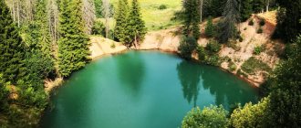
Marble Lake
- Coordinates: 48.203032, 46.795479.
A strikingly beautiful reservoir was formed near the village of Nizhny Baskunchak on the site of a gypsum quarry. The high walls and islands of white gypsum look like marble from afar, which is why local residents nicknamed the pond Marble.
After the quarry was blown up, underground fresh springs were flooded, which, having passed through salty rocks, also became salty, like sea water. The blue pond among the white rocks began to attract tourists, but soon the area lost its spectacular attraction.
In 1998, the gypsum quarries became the property of the German concern Knauf, and the new owner closed access to its territory. Only once a year, on Builder’s Day, local residents and tourists are allowed to swim in Marmara Lake, and hundreds of vacationers gather on the shores of the reservoir.
Volga Delta
- Coordinates: 45.988227, 47.868418.
The mighty full-flowing Volga River pierces the Astrakhan region from the northwest to the southeast, dividing the region into two unequal parts. A few kilometers before it flows into the Caspian Sea, the river divides into many branches, forming a delta.
The Volga Delta is a valuable place both from the point of view of science and from the point of view of tourism, therefore it has a special environmental status. The banks are home to hundreds of plants, including rare species, and countless birds. Some birds live in the delta area permanently, others stop during the migration period.
But the main treasure of the Volga is fish; the river has fed coastal settlements and even neighboring regions since ancient times. Fishing spots in the Astrakhan region are considered one of the best in Russia, and hunting for catches continues in the Volga delta all year round.
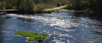
Akhtuba River
- Coordinates: 47.856126, 46.561622.
A well-known and popular river among fishermen flows from the Volga near the city of Volzhsky and flows into the Buzan River near the village of Krasny Yar. The modern name of the river comes from the Tatar phrase “ak-tyube”, which is translated into Russian as “white hill”.
There are several cities on the banks of the Akhtuba, including Akhtubinsk. In the northern part, in the Volga-Akhtuba floodplain, there are endless fertile fields and melon fields. The generous river is rich in fish; every year thousands of fishermen come here from all over Russia, attracted by the large catch.
Gorkaya Rechka
- Coordinates: 48.213128, 46.956090.
The surroundings of Lake Baskunchak look like scenes from a science fiction film or landscapes from another planet. Among the low hills, on the ground white with salt, flows a stream of surprisingly bright red-orange water. The water in the “Martian” river has a bitter-salty taste, hence the name of the reservoir – Gorkaya Rechka.
The river acquires an incredible color in the summer, when salt water reacts with bacteria under the influence of sunlight. The striking feature of the Gorkaya Rechka does not scare away the birds; the birds calmly build nests on the banks of the blood-red stream and hatch their chicks.
Unusually beautiful places in the region
Astrakhan knows how to truly surprise. In different parts of the region there are unique plantings that you would not expect to see in the Russian region.
Lotus fields
- Coordinates: 45.825533, 47.777567.
The most beautiful natural attraction of the region can be seen only once a year near the village of Liman. Between mid-July and mid-September, the river waters are covered with a huge colorful board of blooming lotuses.
The air is filled with the aroma of soft pink relict flowers, and the surface of the river becomes green from huge leaves reaching one meter in diameter.
The delightful landscape attracts travelers; excursions to the “Caspian Rose” valley are in great demand. Picking flowers listed in the Red Book is strictly prohibited, so guests of the valley can only admire the plants from a distance.
Tract Cordon
- Coordinates: 47.392000, 47.850600.
In the Kharabalinsky district, among the fields and melons, hides an unusual plantation, where not the usual watermelons or grain crops grown in Astrakhan, but large desert cacti. The Cordon tract is a natural habitat for the prickly pear cactus.
The exotic plant was planted in these places in 1904-1917 and since then every spring it delights people with large yellow and pink flowers. The prickly old-timers stand out against the background of the Astrakhan steppe and seem to be aliens from distant Mexico. In 1995, the tract was recognized as a natural monument.
Oryol forest
- Coordinates: 47.483333, 47.166667.
The terrain in the Astrakhan region is predominantly steppe or desert, so each area where trees grow is of special importance.
One of these places is the Oryol Forest, located 15 kilometers from the city of Kharabali. The natural monument was named after its creator, the forester Mitrofan Orlov, who proposed planting a forest in order to stop the advancing sands. The tract was laid out at the beginning of the 20th century; over the past hundred years it has grown into a large forest.
In the Oryol Forest there are trees atypical for the local climate: poplars, ash trees, maples. The age of some trees reaches 70 years.
Churkinsky Monastery
- Address: Volodarsky district, village. Churkin.
Near the village of Churkin, the ancient Assumption-Nicholas Monastery has been preserved, but ecotourists are attracted not by the shrines of the reviving monastery, but by the small poplar grove of the same name.
The trees, unusual for Astrakhan, are up to 60 years old. In 1993, Astrakhan specialists proposed creating a natural monument called the Churkinsky Monastery, but the regional administration did not support their initiative.
Where to go with children in Astrakhan
In hospitable Astrakhan, which warmly welcomes tourists, not only adults, but also young travelers are welcome. The city has prepared a wonderful entertainment program for children.
Planetarium
- Opening hours: daily, except Monday. On weekends from 9:00 to 19:00, on weekdays from 9:00 to 17:00.
- Ticket price: adult 250 rubles, children 120 rubles.
- Phone: +7 851 226‑25-76.
- Address: st. Admiralteyskaya, 1/8. Transport stop "Swan Lake".
The city planetarium, established in 1959, is located in a luxurious building built in the middle of the last century, with amazing architectural elegance. It is equipped with the most modern equipment that allows you to create unique effects during a virtual journey through distant galaxies. In addition to the main program, visitors are invited to view an interesting exhibition dedicated to the development of astronautics and admire a wonderful collection of models of rockets, satellites, and airplanes.
Circus
- Working hours: from Wednesday to Sunday inclusive. Performances start on weekends at 16:00, on weekdays at 18:00.
- Ticket prices: from 500 rubles to 1200 rubles.
- Phone: +7 851 251‑14-92.
- Website: https://www.circus-astrahan.ru
- Address: st. Kakhovskogo, 1A. Transport stop "Circus".
There is a special attitude towards the circus in Astrakhan. It is no coincidence that since the middle of the 19th century. century, up to four tents operated here simultaneously, and already in 1898 a building was built for performances by acrobats, jugglers, and magicians, capable of accommodating 1,200 spectators. Circus performances are no less popular today, often attracting full houses. The most famous troupes consider it an honor to perform in the Astrakhan circus; they triumphantly tour different countries of the world. Be sure to take your child to a colorful show performed by wonderful artists.
Park "Planet"
- Opening hours: daily from 10:00 to 23:00.
- Ticket prices: you can ride the attractions by paying from 60 rubles. up to 150 rub.
- Address: intersection of Zvezdnaya and Ostrovsky streets. Transport stop "Park Planet".
The largest entertainment recreation center in the city is exactly the place where a child of any age can have a wonderful rest and gain vivid emotions. There are many attractions here, there are two small ponds on the water surface of which they offer catamaran rides. Those interested are invited to come into contact with wildlife at the petting zoo. For the youngest visitors there is a playground with swings and other safe attractions. Experienced animators conduct colorful performances for kids.
Archeological and historical monuments
Astrakhan is a region with a long history. Hidden under its sands are ancient civilizations, rich cities, destroyed by time and natural elements.
Samosdelskoye settlement
- Coordinates: 46.025556, 47.840556.
The famous archeological monument is located in the Kamyzyaksky district near the village of Samosdelka. Here, on the banks of the Old Volga, scientists have discovered the remains of three disappeared medieval settlements. The most ancient, Khazar, arose in the 9-10 centuries; historians suggest that it was the famous Itil - the last capital of the Khazar Kaganate.
In its place in the 11th-12th centuries, in pre-Mongol times, the trading city of Saksin, or Sajsin, grew up. The latest settlement dates back to the 13th-14th centuries, that is, to the times of the Golden Horde.
Samosdel ruins began to be studied for the first time in 1898. Almost a century later, in 1989, the village teacher Alexander Anatolyevich Pukhov collected an impressive collection of ceramics from the 9-10th centuries near the river and transferred it to the State Directorate for the Protection of Historical and Cultural Heritage. Experts became interested in the finds, assembled an expedition and began excavations at the site of the ancient settlement. Research is still ongoing.
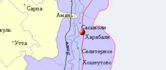
Selitrennoye settlement
- Coordinates: 47.166667, 47.450000.
Not far from the village of Selitrennoye, the ruins of the ancient city of Sarai-Batu, which is considered the very first capital of the Golden Horde, have been preserved. According to historical data, the rich city was built by Batu Khan in the mid-13th century.
During the heyday of the city, there were 75,000 inhabitants; Mongols, Circassians, Byzantines, Russians and other peoples lived in different quarters of the huge capital. The settlement survived many wars; even Tamerlane, for some unknown reason, spared the city, although at the same time he destroyed all the nearby villages.
Saray-Batu existed for a relatively short time; already in the second half of the 15th century its population became smaller and smaller, and over time only a few buildings remained from the city.
In 1710, a plant for the production of saltpeter was built on the site of the once brilliant capital, and at the same time the village of Selitrennoe was founded nearby. The ancient settlement has been studied since the 18th century, and today it has been given the status of an archeological monument of federal significance.
Damn town
- Coordinates: 46.116667, 47.766667.
Another interesting archeological monument is located in the Ikryaninsky district, 4 kilometers from the village of Troitskoye. The remains of a 14th century settlement were found in the 80s of the 19th century, but the first serious study of the settlement was carried out only in 1958 by archaeologist V. A. Filipchenko.
In the 80s, the monument was repeatedly examined by another scientist, Evgenia Shnaidshtein. It is noteworthy that excavations have never been carried out at the site of the ancient settlement; specialists limited themselves to periodic reconnaissance.
Over the years of inspections, archaeologists discovered traces of dugouts, half-dugouts, ruins of a brick structure and a large burial ground on a hillock on the banks of the Bakhtemir River. Fragments of multi-colored tiles, fragments of burnt bricks, fragments of ceramic dishes, items made of non-ferrous metals, coins and even fish hooks continue to be found on the territory.
Semibugra
- Coordinates: 46.164445, 48.255134.
Excavations in the vicinity of the village of Semibugri began quite recently - in August 2022. According to some scientists, it was at this point in the Kamyzyak region, and not near Samosdelka, that the city of Itil stood centuries ago. Archaeologists have discovered the remains of a Khazar settlement with an area of about 150 hectares.
Based on the coins, fragments of ceramics and other artifacts found, it was possible to determine that the ancient city was founded in the 8th century. The discovery caused a sensation in the scientific community; at the moment, experts continue to study the new monument and discuss its significance in world history.
Photos of Astrakhan in the past and present. To the 300th anniversary of the Astrakhan province. Part 3
On the occasion of the 300th anniversary of the Astrakhan province,
Point-A continues to introduce its readers to photographs of old Astrakhan from the photo project of the Head of the State Public Institution of JSC "Astrakhan Regional Resource Center" Vadim Mankov.
The photo shows the building at Chalabyan, 16. In 1946 (at the time of photography) the club of the Stalingrad Suvorov Military School was located here. The school itself was located in Astrakhan from 1943 to 1946. The main building was located at Chalabyan, 17. The official opening of the school took place in December 1943, 612 Suvorov students sat down at their desks.
Last year and in the second half of the 90s.
May 1, 2016 and November 7, 1961
Zvezdnaya Street last year and in the first half of the 80s.
2017 and 1949 The photo from the Volga newspaper shows the entrance to the port territory - the central arch of the 17th pier on what is now Admiralteyskaya Street.
2017 and August 1949. The photo from the Volga newspaper shows the launch of models of warships by young shipbuilders of the Palace of Pioneers. The newspaper wrote: “Last Sunday, unusual flotillas appeared on the May Day Canal. Models of various rubber-powered warships glided across the water. Then small ships with white sails came out onto the water. Numerous spectators who filled the banks of the canal watched with interest the progress of self-propelled floating models. On that day, the first regional competitions in marine modeling were held in Astrakhan. Adult and young shipbuilders submitted more than two dozen models of warships, tugboats and sailing vessels to the competition.”
The intersection of Admiralteyskaya and Nikolskaya now and in the first post-war years. In a large three-story building - the V.I. Hotel. Smirnova (built at the turn of the 19th-20th centuries). The building housed 60 rooms and a restaurant. During the January battles of 1918, the hotel was badly damaged by fire and at the end of the 20s it was almost completely dismantled during the formation of a wide and straight street along the Kremlin wall (now it is Admiralteyskaya). And now we see only a small surviving part of the former hotel building. There are rails in the foreground. Until the mid-50s there was a turning tram ring here.
The intersection of Esplanadnaya and Kommunisticheskaya streets. The tower and abbot's building of the former Spaso-Preobrazhensky Monastery at the beginning of the 20th century (the monastery itself was no longer active by that time).
The intersection of Esplanadnaya and Kommunisticheskaya streets (now and in the 80s). The well-known stop “Tower” and the corner tower of the fence of the former Spaso-Preobrazhensky Monastery (now there is an icon shop).
The intersection of Esplanadnaya and Kommunisticheskaya streets, but only now in 2022 and 1983.
The intersection of Esplanadnaya and Kommunisticheskaya streets now and in the first post-war years. The photo clearly shows the city estate of the Kononovs, built at the end of the 19th century. Further down the street is the red house of E.G. Bukhartseva. It also appeared at the end of the century before last. Both houses are included in the list of architectural monuments.
A section of Kirov Street along the Bratsky Garden last autumn and in the first post-war years.
ACCC now and around 1970. In the foreground on the left is the abandoned pit of an unbuilt swimming pool. Behind him is a “view from the back” of the ACCCC House of Culture. Now here is the cultural center of ASU. Behind the cultural center you can see the buildings of a cardboard and paper workshop. To the right is a three-story building (in the old photograph) - the plant's headquarters. Later it was added to the 1st floor (the green building in the modern photograph). Now here is the administrative building of the Severnaya Thermal Power Plant. Behind this building (in the old photo) is a tall structure and a huge chimney. This is a soda recovery boiler designed to regenerate chemicals used in the production of pulp using the sulfate method with heat recovery to produce steam for energy parameters. That is, the heat from burning the lye was additionally used for production needs and heating the village. And the missing amount was generated by a thermal power plant. Since paper is no longer boiled here, the building along with the pipe was dismantled. In a modern photograph we see the new pipe of the Severnaya CHPP. On the right, towards us, is Mosin Street. The photographs were taken from the side of Bumazhnikov Avenue.
The former tram stop at the intersection of Sverdlova and Admiralteyskaya streets last summer and in the first half of the 80s.
Church in honor of the Holy Equal-to-the-Apostles Prince Vladimir last fall and in the 1950s. The temple was consecrated in July 1902. Closed in 1939. After closing it was used as a warehouse. At the end of the 1960s, a bus station was opened in the temple building. In July 1999, the bus station was moved to the old railway station building, and the temple was returned to the Russian Orthodox Church.
The intersection of Sovetskaya and Kommunisticheskaya streets, a festive demonstration on March 8, 1923.
Three pseudo-panoramas of the Astrakhan Kremlin. The top row is made up of two photographs from 2015; the middle one is from two photographs from 1979; the bottom one is from photographs taken in 1894.
Persian mosque on the street. Kirov before the revolution and now. The minarets were dismantled when the mosque was converted into a sewing workshop in 1939.
The area of the stadium and Latyshev Street (until 1957 - Boldinskoe Highway) now and in 1943. On the left is the city water intake that moved here before the war. Then there is a vacant lot where a stadium will appear in 1955. Then along Pryamaya Bolda there is a large territory of a cooperage factory. He first bore the name of Stalin, then Kalinin. Now here is the Astrakhan “Santa Barbara” - a small cottage community. Then, refrigerator buildings are visible on both sides of the railway bridge. And further to the right of the bridge is a fish factory.
Theater Park now and Leninsky Park in 1943.
Photo from the Prechistenskaya bell tower of the Kremlin. Much has changed in the decade separating the photographs.
To be continued.
Previous materials:
Mentions of Astrakhan: enthusiastic and not so... Mentions of Astrakhan: enthusiastic and not so... Part 2 Taras Shevchenko. “Oh yes Astrakhan! Oh yes, the port is a city. You won’t find fish soup” “Spoil the City”: Astrakhan through the eyes of Ivan Aksakov. Part 1 “Spoil the city”: Astrakhan through the eyes of Ivan Aksakov. Part 2 Nemirovich-Danchenko. Along the Volga: essays and impressions of a summer trip. Part 1 Nemirovich-Danchenko. Along the Volga: essays and impressions of a summer trip. Part 2 Nemirovich-Danchenko. Along the Volga: essays and impressions of a summer trip. Part 3 Nemirovich-Danchenko. Along the Volga: essays and impressions of a summer trip. Part 4 Artists brothers Chernetsov. Astrakhan II half of the 19th century Astrakhan province of the 19th century. on unique photographs by S. Vishnevsky Vintage photographs of S.I. Klimashevskaya. The first Astrakhan tram The first postcards with views of the Astrakhan region V.A. Sergeeva. The end of the 19th century in the Golden Fund of Astrakhan photography. Mikhail Alekseevich Kozlov Photos of Astrakhan in the past and present. To the 300th anniversary of the Astrakhan province Photos of Astrakhan in the past and present. To the 300th anniversary of the Astrakhan province. Part 2
Other interesting sights of the Astrakhan region
There are several natural monuments within and outside the reserves that deserve special mention.
Dune "Big Brother"
- Coordinates: 46.430284, 47.492575.
The area in the west of the region is mostly deserted; here you can admire real sand dunes. The largest dune was called “Big Brother”.
It is believed that this name was given to him by the racers who regularly organize the “Kagan’s Gold” competition in the desert. The wind, like a sculptor, works with inspiration on the sand hill, constantly changing the shape and size of its creation. Only SUVs can drive through sandy terrain. The road to the dune is impassable, so getting to it on your own is almost impossible.
Tourists, as a rule, visit the attraction as part of an excursion group, using suitable transport and accompanied by an experienced guide.
Hillock Black
- Coordinates: 46.267990, 48.193641.
Cherny Hillock is the most famous of the Baer hillocks, named after the first explorer K. M. Baer. Cherny is one of the few hillocks in the Ilmenno-Bugrovy Nature Reserve that have escaped the harmful influence of humans.
Thanks to this, the natural monument has been preserved in its original form; such rare and amazingly beautiful plants as sand poppy, Bibirstein tulip, dwarf iris and others still grow on it.
Rollers and bee-eaters nest on the slopes of the hillock. In the fall of 1999, a worship cross was erected on the top of the hill, symbolizing the inviolability of Russian borders.
Hill of Snakes
- Coordinates: 46.350000, 48.716667.
10 kilometers from the village of Marfino there is a Botanical hillock, interesting from a botanical point of view, nicknamed Zmein. Zmeiny, together with the neighboring hillock Bolshoi Barfon and the surrounding territory, is protected by the state. In the mid-90s, this area of the landscape received the status of a natural monument.
Scientists became interested in the hillocks for a reason: Zmeiny is the only place in Russia where a very rare tropical plant, the Volga globulus, grows, whose homeland is considered to be the valley of the Tigris and Euphrates rivers. At the foot of the Great Barfon grows another endangered species - the water fern, or Marsilea Egyptian.
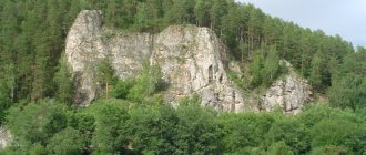
Baskunchak Cave
- Coordinates: 48.283056, 46.797222.
There are three dozen caves on the territory of the Bogdinsko-Baskunchaksky Nature Reserve. The largest of them, originating from the shore of Lake Baskunchak, pierces the ground to a depth of about 32 meters and has a total length of 1.5 kilometers.
The huge karst cave is considered the longest not only in the reserve, but in the entire territory of the Northern Caspian Sea. The cave is mostly dry, but there is a small freshwater lake inside.
The underground tunnel has three entrances; for many years they were considered separate caves. The cave has been known since the 19th century; inscriptions left by travelers back in 1874 are preserved on its walls.
The first serious study of the area was carried out in the 1940s by Saratov scientist A.D. Gedeonov. Over time, not only speleologists, but also ordinary tourists began to visit the cave. Today Baskunchakskaya is one of the most popular natural sites in the reserve.
Maly Zhemchuzhny Island
- Coordinates: 45.048611, 48.310000.
A small area of land in the Caspian Sea appeared on world maps relatively recently - in the 30s of the last century, when the level of the Caspian Sea fell. One of the shallows came to the surface and turned into an oblong island.
The area of the island is constantly changing, it reached its maximum size in the 70s, then its length was 10 kilometers and width - 400 meters. Over the past decades, the length has decreased three times.
Maly Zhemchuzhny became famous thanks to the large population of endemic Caspian seals, which chose the island as a rookery. At the beginning of spring and at the end of autumn, thousands of heavy carcasses wash up on the shores.
Also nesting on the land are endangered bird species such as the herring gull, black-headed gull and spotted tern. The fauna of the island attracts the attention of scientists from all over the world; famous film companies in Britain, France and other countries make documentaries about the natural monument.
Clean Bank Island
- Coordinates on the map: 45.211069, 48.027545.
The small island, 6 kilometers long and 4 kilometers wide, is interesting for its history. Pure Bank is one of the supposed locations of the legendary Itil. Some researchers, in particular historian Konstantin Vasilkov, believe that the remains of the city are underwater near the shores of the island.
Konstantin Nikolaevich cites photographs from space and chronicles about Itil as evidence of his theory: medieval authors wrote that a wall with a diameter of 5-6 kilometers was built around the city, and the photographs show a polygon with the same diameter. The island itself was inhabited until recently, but nowadays it is inhabited only by birds.
Don't miss the sights of the regions neighboring the Astrakhan region - the Volgograd region and the Republic of Kalmykia
You may also be interested in interesting places in the cities of the Astrakhan region - Astrakhan
The Astrakhan region is unlike any other region in Russia. Traveling along southern roads, you suddenly find yourself in the Mexican desert, overgrown with cacti, or in the Chinese province, in the land of fragrant lotuses. This land is full of surprises and will be able to impress even the most sophisticated tourists with its attractions!
Main attractions of Astrakhan
The sights of Astrakhan, photos and descriptions of which you will find in this article, are very diverse. Some of them are considered unique calling cards of the city.
Astrakhan Kremlin
- Address: transport stop "Oktyabrskaya" square.
The perfectly preserved fortress is a wonderful example of Russian fortification art of the 16th century. The citadel, founded under Ivan the Terrible, took more than 25 years to build. It has thick walls, the height of which in some places reaches 8 meters, and 7 powerful towers. The fortress, built on a hill in the middle of the island, still looks impregnable. Now it is a wonderful architectural and museum complex. On its territory there are many historical buildings, the Trinity and Assumption Cathedrals, and several interesting museums.
Monastery of John the Baptist
- Opening hours: daily, from 7:30 to 19:00.
- Telephone.
- Website: https://www.ioanno.ru
- Address: st. Magnitogorskaya, 9. Transport stop “Bolshiye Isady”.
The founding date of the monastery is considered to be 1688, when the authorities gave permission to build a church in a settlement of monks, outside of what was then Astrakhan. Nine years later, a delightful temple with an elegant bell tower was erected here, the main shrine of which was considered the miraculous image of John the Baptist, now lost. Subsequently, several more small churches and buildings were built on the territory of the monastery. After the Revolution, all the property of the monastery was requisitioned, and the novices returned here again in 1995. After the restoration, the monastery looks magnificent.
Opera house building
- Address: st. Henri Barbussa, 16. Transport stop "Opera and Ballet Theatre".
Since its grand opening in 1994, the building that became home to the Astrakhan Opera and Ballet Theater has become an iconic city landmark. The building with an eclectic exterior is not inferior in splendor to palaces. Huge arched windows, elegant turrets, hexagonal domes covered with tiles create a unique architectural composition that you can admire for hours. The aesthetic impression is enhanced by the lush design of the facade. It is decorated with carvings, stucco moldings and other elements of architectural decor.
Astrakhan TV tower
- Address: st. Lyakhova, 4/5. Transport stop "Selenskie Isady".
The fact that the TV tower has become a kind of calling card of Astrakhan is not at all surprising. The elegant structure, erected in 1967, has a height of 180 m, so you can admire it not only from any part of the city, but also from the surrounding villages within a radius of 10 km. The structure, made of high-strength steel, looks especially interesting in the evenings when the lights turn on. By the way, the TV tower is nominated for entry into the Guinness Book of Records as the least energy-intensive structure of this type in the world.
Swan Lake
- Address: st. Admiralteyskaya. Transport stop "Swan Lake".
The unique natural recreation around a fabulously beautiful lake, along the surface of which snow-white swans move gracefully, is not only a favorite vacation spot for city residents, but also an iconic landmark of Astrakhan. Stone stairs descend to the shore of the reservoir. There are alleys and neat lawns laid out around it. There is a delightful rotunda in the center of the lake. She looks so lightweight that she seems to float above the water. It’s simply impossible not to take a stunning memorable photo against the backdrop of this magnificence.