The Perm region is located on the eastern edge of the Russian Plain and the western slope of the Middle and Northern Urals , at the junction of two parts of the world - Europe and Asia . The geographical location of the region, its flora and fauna constitute a rich potential that one can admire and rightfully be proud of.
The Perm region is a territory of developed industry and business, art and culture, glorious history and rich natural resources. The region has many different architectural monuments and simply beautiful corners.
Mountains and rocks of the Perm region
The first mentions of this territory began to appear in the 12th century, when it was called “Great Perm”, or the Far Land. From here the Russian exploration of the Urals and Siberia began. It is impossible to imagine the Perm region without mountains. They were here before the arrival of people, saw the dawn of civilization and will probably die along with the planet. Here, every rock, every mountain, every stone has its own special name.
Ermak stone
- Coordinates on the map: 57.380551, 57.121596.
The limestone rock, named after the famous Cossack chieftain, is located in the Kungur region of the Perm Territory. However, this is not only a tourist attraction, but also a local natural monument. And it is notable for its three peaks rising above the Sylva River.
The highest, 40 meters, is named Ermak. Its peak is densely overgrown with pine forest, and the slopes are popular with climbers. The Ermachikha cliff is slightly smaller, its height is 30 m. And the very small Ermachenok is about 15 m high. It differs from its neighbors in that its peak has a pointed shape, and the slopes are devoid of vegetation.
Mount Polyudov stone
- GPS coordinates: 60.484513, 57.004295.
The highest point of the Polyud Ridge is named Polyud Mountain and is a Natural Monument of regional significance. According to ancient Komi-Permyak legends, it is named after a hero with remarkable strength. When an enemy came to Earth, Polyud heroically fought against him and won. Now the hero is sleeping in grief until his homeland is again in danger.
The height of the mountain is 527 m. Its slopes are steep, especially the northern one, and covered with coniferous forests. The best view of it opens from Cherdyn, from there the rock looks like the crest of a giant sea wave. Every year the festival “Heroes of the Land of Visherskaya” takes place in these places, and a television tower is installed on the top of the rock.
Usva pillars
- Coordinates: 58.653397, 57.569167.
The ancient limestone massif on the right bank of the Usva stretches for several kilometers. Today it is part of the land, but the age of the fossils that are still being excavated here indicate that thousands of years ago there was a sea here.
Since 1965, the pillars have the status of a Natural Monument of regional significance, and tourists call them the calling card and pearl of the Perm region. Many come specifically to see this miracle of nature.
The height of the Usva pillars reaches 120 m. They offer a beautiful view of the stormy Usva, the Big Log and Panoramic stones. And climbers are attracted by a separate 70-meter outcropping, named Devil's Finger.
Getting to its top is very difficult; more than one accident has occurred during the climb. However, it continues to attract climbers, and at one time a tourist flag fluttered at its top, erected in honor of the conquest of this dangerous rock.
Topic: Entertainment in Perm for children
Vakutin stone
- Coordinates: 56.959930, 57.427518.
In the Komi-Permyak language, its name sounds like “Mountain Embracing Water,” and locals most often call this place the Gray Stone. From here there is an amazing view of the Irgina River, flowing right under the rock, a dense forest and the heavenly distance. The river in this place makes a 180-degree turn, as if hugging the Vakutin stone.
The rock is included in the register of Natural Monuments of regional significance. Once upon a time, the Perm Sea overflowed at this place, and the mountain is the remains of an ancient reef. Traces of extinct marine animals are still found in its vicinity.
Kvarkush Ridge
- Coordinates: 60.201667, 58.725000.
The attraction is located in the Krasnovishersky district of the Perm Territory and is considered one of the most popular and visited. It is especially loved by fans of wild tourism. The name of the ridge is translated as Naked Ural, but this is in the Komi language, while the Mansi prefer to call it Purap.
Kvarkush stretches from north to south for about 60 km. There is practically no vegetation on its stone placers, except for creeping shrubs, mosses and northern berries.
The nature here resembles the tundra, sometimes even reindeer and bears can be found. But most interesting are the picturesque peaks and rocks located at different heights. The most important one is the Vogulsky stone - 1066 km high. The rest are impressive just by the name - Kvarkushonki, Three Brothers, Coffin... They are definitely worth seeing.
Kolchima stone
- Coordinates: 60.330542, 57.609878.
The mountain has a second, more ancient name - the Remembered Stone - and is a continuation of the Polyudova Ridge. It is located in the north of the Krasnovishersky district and is very popular among tourists. Despite its low height of about 780 m, it is already an impressive sight from afar.
The rock resembles the ruins of a beautiful castle or some fantastic animal. Pomenennaya Mountain owes its appearance to the many stone remains made of quartz and sandstone. Many of them reach a height of more than 30 m and have a special bizarre shape.
Stone City
- Coordinates: 58.722669, 57.633268.
Tourists know this unique landscape natural monument of the Urals under this name. Although it has an older name - Devil's Settlement, which was given to it by local residents, considering it unclean.
The stones are millions of years old. They arose back when the ancient river flowed into the Perm Sea and made its way through the rocks. Today, such stones are called “houses”, the height of some of them reaches 12 m. You can get into the Stone Town through an arch called the “Gate”, and rocky remains resembling frozen animals live in it. There is a Seal and a Turtle, a Rat and even an Idol - the permanent city guard.
From the heights of the remains there is a wonderful view of the Ural taiga, but it is not always possible to catch it. After all, most often the surrounding area is cut off from the Stone Town by a thick curtain woven from fog.
Vetlan Stone
- Coordinates for the map: 60.476712, 57.099649.
Vetlan stretches like a rocky wall along the Vishera coast for 1750 km. Almost all of its cliffs are at least 100 m high, and the highest rises 263 m above sea level. A real legendary hero who deserves the love of the beautiful Vishera.
From its top there is an amazing panorama of the Polyudov Stone and Vishera, winding between them like a winding ribbon.
From here you can even see the ridge islands that were built by prisoners to form dams and redirect the rafted timber. Every year, millions of tourists strive to conquer this giant stone fence, and many succeed.
Third day of the road trip
The main purpose of visiting the city of Krasnovishersk was to climb the Vetlan stone. That's where we're going.
Vetlan stone on the Vishera River
The Vetlan stone on the Vishera River is one of the majestic rocks of the Ural Mountains of the Perm Territory.
The Vetlan stone is an almost vertical stone wall with a height reaching almost 265 meters, stretching along the Vishera River. Even in ancient times, the stone massif amazed people’s imagination, connecting the origin of the Vetlan stone with a beautiful legend about heroes who lived in ancient times and a young girl in love...
GPS coordinates of Vetlana: N 60º28,594´; E 57º05.846'.
In order to get to the rocks, you need to drive through the city of Krasnovishersk along the Vishera River (the river should be on your left). After finishing a good road, having passed the outskirts of the city and several tourist centers, you can leave the car and continue walking. You can also drive to the foot of the mountain in an SUV. The distance from Krasnovishersk is about 8 km. From the last tourist bases it is about two kilometers.
Let's go back along the previous tracks. Unfortunately, the track from Krasnovishersk to Usolye and further to the town of Chusovoy was not recorded. Having reached the town of Bereznyaki, we follow the signs towards the town of Usolye.
Usolye city
In the past, Usolye was called new Usolye.
Like Kamskaya Salt, Novoye Usolye owes its existence to the table salt mined here. It was the patrimony of the largest Russian merchants and industrialists, the Stroganovs - first eminent people, and then barons and counts. The Stroganovs not only gave the name to this small but very significant settlement, but also decorated it with magnificent stone buildings, which, together with other, later buildings, made up an interesting architectural complex of the 18th - 19th centuries, which became one of the best attractions of the Perm region.
After a walk through the sights of Usolye, we go towards the town of Chusovoy, where we spend the night.
You can spend the night at the Chusovskaya Hotel - rooms range from simple multi-bed rooms to suites. Prices are reasonable. Address of the Chusovskaya Hotel: 618206 Perm Territory, Chusovoy, st. 50 years of Komsomol, no. 27. Tel. /fax 8 (34 256) 4 - 85 - 26, 4 - 69 - 41 Website: Hotel "Chusovskaya" There is no guarded parking at the hotel, we do not recommend leaving it on the street. There is paid parking approximately two blocks from the hotel.
Perm caves and gorges
Famous caves and mountain gorges are the special pride of the Perm region. There are a lot of them in these places and each such attraction is unique and inimitable in its own way.
Kungur cave
- Address: Filippovka village, Kungur district.
The ice cave is considered not only the main pearl of the Perm region, but also one of the most impressive in the world. The first mentions of it date back to 1703, and already in the 19th century local peasants began to conduct excursions for travelers there.
The insides of the cave are about 50 large and huge ice grottoes, 60 crystal clear underground lakes and 146 through shafts connecting the cavity with the surface, over a length of more than 5700 m. The air passing through the shafts creates wonderful sounds, for which the phenomenon was called “organ pipes” . The highest of them, 22 meters, is located in the Ethereal Grotto.
The tourist route has a length of about 1500 m. Along the entire route, for the convenience of travelers, paths are equipped and lighting is organized to enhance the impression of the magical spectacle.
Babinogorskaya cave
- Address: s. Babina Gora, Kungur district.
Not far from Kungur, in the village of Babina Gora, there is an interesting gypsum cave, which is often compared to Ordinskaya. The entrance to it is a vertical well located right in the courtyard of a residential building. Through it, visitors enter the grotto, the walls and ceiling of which are covered with carved snow lace in winter.
Three corridors lead out of the grotto. Two of them end in dead ends, and the last one leads to a cave with an underground lake. In winter, the reservoir is covered with fragile ice, ready to collapse at any moment, and bizarre stalagmite columns grow from the floor.
If you move further, you can get into the Labyrinth - a small system of tangled underground passages. There, every now and then, there are “organ pipes” emerging to the surface like karst funnels. But most of the Babinogorskaya cave is hidden under water and is not yet accessible even to speleologists.
Miracle Cave
- Coordinates: 58.200749, 58.142864.
It is located in the Chusovsky district and is considered one of the most beautiful caves in the region. Getting into it is not so easy; the entrance is located at an altitude of 50 meters and is a narrow gap in one of the slopes of Mount Kladovy Kamen.
The cave was formed thanks to the flow of an ancient underground river, which dried up over time and left us with wonderful galleries with many grottoes, passages and partitions.
All the beauty and unusualness of the cave are the deposits, stalactites and stalagmites, among which there are even hollow ones called “pasta”, “moon milk”, helictites and corallites, cave pearls. One of the most beautiful deposits is even called the Master of the Cave.
Interesting names are given to the most beautiful grottoes, striking the imagination with patterns and weaves:
- Lobby,
- Sink,
- Hope,
- Devil,
- Dolphin.
Unfortunately, less and less of its pristine beauty remains every year. Visitors to the Wonder Woman break off stalactites and deposits in order to take at least a small part of her with them.
Kizelovskaya Cave
- Coordinates: village. Mine, Kizelovsky district.
It can be found in the Gubakhinsky district of the Perm Territory, which is generally considered a paradise for speleologists. The cave was declared a Natural Monument of regional significance and has a second name - Visherskaya. It is the second longest (7600 m) in the Perm region and one of the most difficult and dirty.
It is unrealistic to go down into it without special equipment and minimal skills. It is also necessary to know the entire complex system of wells, galleries and corridors, because you can very easily get lost in it.
The cave is interesting because of its bizarre sinter formations, stalagmites and stalactites, and in one of the grottoes the head of the Owner of the cave is sculpted from clay. Tourists and speleologists leave him offerings and ask for favors.
And the original names of the cave rooms - Walking Through Torment, Trams and Metro, Giant, TV, Organ Pipe, Gallery of Wonders - have long stirred the memory with their unusualness and original beauty.
Orda Cave
- Coordinates: 57.182407, 56.888165.
This is another natural monument of the Perm region and a real paradise for fans of cave diving. It is located in Mount Kazakovskaya, on the left bank of the Kungur River, and is considered the longest gypsum underwater cave in Russia.
Its study began at the end of the 20th century. In the early 1990s. The dry part of the cave was fully explored, and in 1994, diving into the underground lake began. So it became known that the land part is only 300 m, and the remaining 4300 m belong to the water space.
The cave begins with 3 small grottoes with beautiful names: Ice Palace, Crystal and Maksimovich. In winter, there are a lot of ice formations and deposits, and the floor is strewn with fallen plaster blocks. Another grotto, the Dry Hall, is located behind the underwater part of the cave.
From it you can get into the main underwater passages, named after Russian cities: Chelyabinsk, Moscow, Sverdlovsk, Krasnoyarsk. Here is the longest underwater siphon in Russia and the CIS. Its length is 935 m.
Reservoirs and waterfalls of the Perm region
In terms of the number of reservoirs, the Perm Territory ranks first among the Ural regions. All of them in one way or another belong to the Kama Basin. But there are very few natural waterfalls here, but those that exist evoke admiration for their power and beauty.
Plakun Waterfall
- Coordinates: 57.190146, 57.474305.
This beautiful waterfall is located near the village of Suksun, on the right bank of the Sylva. According to legend, these are the tears of a girl who was forcibly separated from her lover and imprisoned in the depths of a mountain. It's quite small.
The water gushing from the springs at the top of the mountain falls from a 7-meter height in three streams, powerful enough that it is not so easy to stand under them. In addition, it is always icy and after a few minutes it is impossible to be under it. But it tastes very pleasant and is considered healthy due to its carbon dioxide content.
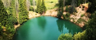
Blue Lakes
- Address: pos. Limestone quarry, Aleksandrovsk.
These reservoirs are nothing more than flooded limestone quarries left here after the activities of the Stroganov merchants. Their uniqueness lies in the wonderful turquoise surface of the water, the color of which is given by particles of limestone and copper. The most famous of them are Shavrinskoye and Morozovskoye.
The first has a depth of 72 m and is considered the deepest reservoir (including artificial ones) of the Kama region. The second, named after Savva Morozov, who owned the local factories at the end of the 19th century, is not so deep, but stretches 4 km in length.
Zhigalan waterfalls
- Coordinates: 60.167283, 58.810497.
This, the most beautiful waterfall cascade in the Perm region, is located on the mountain river Zhigalan, originating on the eastern peaks of the Kvarkush ridge. Their total length is about half a kilometer, and the height difference between the sources of the river and its mouth is 630 m.
There are several powerful waterfalls, but the lower cascade is considered the most beautiful. It falls into the valley from a 15-meter height, roaring, jumping over huge boulders and scattering snow-white foam in front of it.
The water here is always clean and cold, because Zhigalan originates on peaks covered with eternal snow. In 1991, the Zhigalan waterfalls received the status of a hydrological natural monument of regional significance.
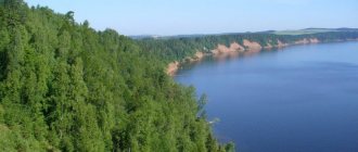
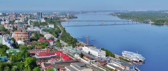
Chusovaya River
- Coordinates: 60.635391, 58.055548.
This river is the most famous in the Perm region, the only one that came from behind the Ural Mountains and made its way through them. The river valley is considered one of the most ancient in the region, and its name, according to one version, means “Sacred River”.
The banks of Chusovaya are a very picturesque sight - limestone, shale, dolomite rocks of the Permian and Devonian periods, numerous karst caves and arches. Most of them have their own original names and are classified as Natural Monuments.
It is also interesting to archaeologists. Many sites of ancient man from the Bronze and Neolithic times were found on its banks. But judging by the fact that the research has been inconsistent, the main discoveries are yet to come.
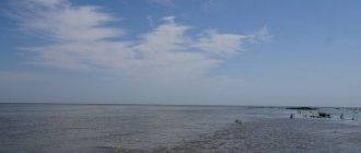
White Sea
- Address: st. Novosodovaya, Berezniki.
A charming seascape that would be more appropriate on some tropical island can be captured in Berezniki. Beautiful white sand and bluish-turquoise water invite you to take a dip or walk barefoot on the beach, but you shouldn’t do this.
The local sand is nothing more than sludge - waste from soda production from a plant located nearby. They also color the water in such an unusual shade. You cannot swim here due to the viscosity of the sludge, but you are allowed to admire the amazing view from the dam.
Copan Canal
- Coordinates: 57.898180, 54.345450.
The man-made canal, which today has become one of the main attractions of the Ochersky district, was built to connect the Ocher and Chepets rivers and increase the capacity of the Ochersky plant. For 2 years, 5,000 serfs from 4 volosts dug it by hand, without stopping work even in winter. A tremendous amount of work was done, but it was in vain. There was still not enough water.
Today it is one of the favorite places for tourists. In the summer, you can swim here in the cool water and admire two 10-meter waterfalls falling into the canal. One of them is a small river flowing from Chepts, the other is a stream that originates in a nearby swamp.
The fourth day of auto travel in the Perm region
On the last day of traveling by car in the Perm region, we visit two interesting sites from a historical point of view: the Memorial Complex of Political Repressions Perm-36 and the Ethnographic Park of the History of the Chusovaya River.
Memorial complex of political repressions Perm - 36
Memorial complex of political repressions Perm - 36 is, perhaps, the only museum of the history of political repressions in Russia.
The location of the complex was not chosen by chance; it was in the Perm region that the first Gulag labor camps were created in 1929, and only in 1988 the last of the political camps was closed.
The Perm-36 museum complex was created in 1994 on the territory of a labor camp for political prisoners that operated on this site.
Coordinates of the Memorial Complex of Political Repressions Perm-36: N: 58' 15,510; E: 57' 25.573.
From the town of Chusovoy you need to go towards the village of Kuchino, the distance is approx. 50 km.
Ethnographic Park of the History of the Chusovaya River
The ethnographic park of the history of the Chusovaya River, located in the valley of Arinina Mountain, on the banks of the playfully murmuring Arkhipovka River, was founded in 1981 on the basis of the Ogonyok Olympic Reserve children's school.
The creator and ideological inspirer of the Ethnographic Park and Ogonyok is Leonard Dmitrievich Postnikov, a famous cultural and sports figure not only in the city of Chusovoy and the Perm region, but also far beyond their borders. The park is interesting for its huge and unique collection of peasant household items from the 19th and 20th centuries. In the park you can see not only ancient wooden huts and chapels, but also a fire station, a village store, which has “whatever there is!” Separate exhibitions are dedicated to the history of Ermak.
Coordinates of the ethnographic park of the history of the Chusovaya River: N: 55' 24,191; E: 60' 08.282.
From the town of Chusovoy we drive along the Gornozavodsky tract to the Ogonyok sports base, the distance is about 5 km.
Next we move towards the house...
Track of the fourth day (bottom of the page): Perm region day 4: Chusovoy - Perm-36 - Chusovoy River Park - Yekaterinburg.
In our case, the road route around the Perm region lasted only four days. But it can be extended for a longer period of time and cover other interesting places in the Perm region.
What else can you see in the Perm region:
Trophy route in the Perm region Sign Europe - Asia near the Evropeiskaya station
Perm reserves and reserves
The unique nature of the Perm region is worthy of preservation, because it is a universal heritage that we are obliged to pass on to our descendants. For this purpose, entire protected areas and security zones are created on its territory. So far there are only two of them, but developments in this direction are still underway today.
Vishera Reserve
- Coordinates: 61.483333, 59.216667.
The purpose of its creation was to preserve the unique nature of the northern Urals. On an area of more than 240 thousand hectares there are virgin taiga forests, mountain ranges, clear streams and crystal waterfalls, large populations of animals, including many from the Red Book, and more than 400 species of plants. The Molebny ridge, sacred to the Mansi, as well as the Saklaim-Sori-Chakhl peak, the border between Europe and Asia, are considered unique objects of the reserve.
Basegi Nature Reserve
- Coordinates: 58.857423, 58.468288.
This reserve was created in the 80s. last century in order to preserve the taiga forests of the Western Urals. It is named after one of the highest peaks located on its territory.
Today, the reserve is home to more than 500 fauna representatives, many of which are considered rare and are listed in the Red Book. The flora here is represented by trees, shrubs and herbs, of which 17 species are endemic, not found anywhere else in the world. Relict plants from the pre-glacial, glacial and post-glacial periods were also discovered here.
Picturesque landscapes and rocky ridges attract tourists here. Some of them come as volunteers to help reserve workers with construction work, clearing areas and counting inhabitants.
Second day of traveling by car in the Perm region
City of Solikamsk
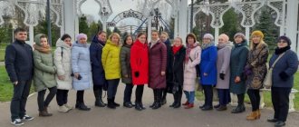
In the morning we walk around Solikamsk, visiting the main city museums.
Founded in the 15th century, the city of Solikamsk (follow the link - detailed information about the history of the city and its main attractions), historical name - Sol Kama, is simply full of interesting architectural and historical monuments.
In Solikamsk you can visit a unique ensemble of churches built in the 17th - 18th centuries, and an open-air museum - the Museum of the History of Salt of Russia, and taste the water of the preserved Lyudmilinskaya well, drilled in 1906 - 1907 - one of the oldest salt wells cities.
Cherdyn city
The next point on our route is the city of Cherdyn - the most ancient city of the Kama region.
It is located deep in the taiga forests of the Perm region, on the right bank of the fast-flowing Kolva River, six kilometers from its confluence with the Vishera. Its few buildings stand on a high ravine bank. Historical information about Cherdyn is extremely meager and fragmentary. The time when the city was founded is also unknown... In fact, Cherdyn is a historical landmark. In every corner, in every Cherdyn house you can find echoes of the history of the formation and development of the Kama region.
After walking through the historical streets and museums of Cherdyn, you should definitely get to the village of Nyrob, which became notorious due to the imprisonment and death of boyar Mikhail Romanov on its territory...
On the way to the village of Nyrob we stop at a natural and historical site - Narrow Street and Iskorskoye Settlement.
Narrow street and Iskorsk settlement
The narrow street and the Iskorskoye settlement are a landscape natural monument of the Perm region.
A place interesting both for its unusual appearance and its history. A narrow street - a narrow gap - a corridor, located in a rocky massif, about 60 centimeters wide, no more than 40 meters long. According to legend, if you pass through the narrow street through which Paraskeva Pyatnitsa, the defender of the ancient town of Iskor, was carried out and executed many centuries ago, all sins will be forgiven. The Chapel of Paraskeva Pyatnitsa stands not far from Narrow Street - on the site of the ancient Iskor settlement. Coordinates of Narrow Street: N 60º41,006´; E 56º45.669'.
Coordinates of the Iskor settlement: N 60º41,184´; E 56º45.667'.
The narrow street and the Iskorsk settlement are located about five kilometers from the village. Nyrob, incl. a couple of kilometers along the grader. A little before reaching the villages of Nyrob and Lyunva, you need to turn right - towards Narrow Street and the Iskorsky settlement. Rotation coordinates: N 60º41.300´; E 56º43.044'.
Village Nyrob
The small village of Nyrob, founded in 1579, became famous not only in Russia, but also abroad, thanks to its bloody history.
It was in the village of Nyrob of today's Perm Territory that Mikhail Nikitich Romanov (the uncle of the first tsar of the Romanov family, Mikhail Fedorovich Romanov) was exiled to harsh imprisonment in 1601, where a year later he died in a specially dug hole for “allegedly wanting to poison Tsar Boris Godunov.” .
A walk around Nyrob will not take much time...
Then we move a little back, towards Cherdyn, after which we go towards the city of Krasnovishersk, where we stop for the night: the hotel is located right at the entrance to the city.
Track of the second and partly of the third day (at the bottom of the page): Perm region day 2-3: Solikamsk - Cherdyn - Iskorskoe ancient settlement - Nyrob - Krasnovishersk - Vetlan stone. Note on the track of the second day: the track starts from the Museum of the History of Salt, Borovsk district, st. Newspapers Zvezda, 2.
Mysterious sights of the region
The entire Perm region is shrouded in a mystical veil. Here, anomalous zones and otherworldly events occur almost out of the blue, and legends about them go far beyond the region.
Moleb triangle
- Coordinates: 57.194971, 57.883638.
This anomalous zone, located between the villages of Kamenka and Molebka, is of particular interest to ufologists. Here, quite often, according to eyewitnesses, paranormal phenomena occur: objects rise into the air, luminous balls, ghosts are visible, and even aliens land.
In the old days, this territory on the left bank of the Sylva was considered sacred for the Mansi. Sacrificial rituals were regularly held here and a sacrificial stone was installed. And strange phenomena were noted at the beginning of the 20th century.
Once in Molebka, people begin to experience all these strange things for themselves. Many people develop a fever, a strange rash or a headache. They are overcome by inexplicable anxiety and excitement.
White Mountain, Vyselki, Druid Grove, Pyramids - all these are the names of the most mystical places in the Triangle, where inexplicable events occur. Most legends, rumors and prophecies are associated with these places; they are also included in most tourist routes.
Hell Lake
- Coordinates: 60.221042, 52.962908.
The mystical reservoir is located in the floodplain of one of the most inaccessible rivers in the Gainsky region - Poryshe. According to ancient legends, the evil god Kul lives in it, taking the form of a pike and dragging fishermen to hell through a funnel at the bottom of the lake. Maybe that’s why, or maybe because snakes are found in large numbers on its shores, the reservoir began to be called Hell’s Lake.
In the spring, strange geological processes begin to occur at its bottom, as a result of which the entire surface of the lake seethes and bubbles. This adds mystique to the strange body of water and confirms what is said in ancient legends. And if you believe more modern rumors, at its bottom there is a cemetery for radioactive waste that was dumped into it from airplanes.
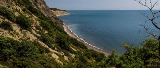
Mount Zarathustra
- Coordinates: 58.166701, 56.348677.
This is the name of Cape Strelka, located where the Kama and Chusovaya merge into a single whole. It is believed that this is where cosmic energy accumulates, the presence of which is noted by those who have visited this unusual place.
Moreover, if you believe the legends, the prophet Zarathustra was born here and received Divine Revelation. Whether this is true or not is not known for certain, but the mountain and its surroundings are always full of tourists. Some are interested in stunning views, others come to get a boost of cosmic energy.