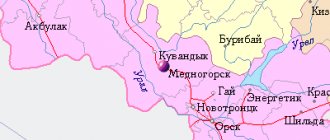
Kharabali
(Astrakhan region)
OKATO code:
12245501
Founded:
1770
City since:
1974 City of district subordination (Kharabalinsky district of the Astrakhan region)
Center:
Kharabalinsky district
Telephone code (reference phone)
| 85148***** | 51-409 |
Deviation from Moscow time, hours:
1
Geographical latitude:
47°24′
Geographical longitude:
47°15′
Altitude above sea level, meters:
0 Sunrise and sunset times of the Sun and Moon in the city of Kharabali
Story
The village of Kharabali was founded in 1789 by fugitive peasants from the central provinces of Russia - Voronezh, Tambov, Kursk - on a high hillock [1].
There are several versions of the origin of the name Kharabali. According to one, the name of the village comes from a hillock that once divided the village into two parts, Kharabali (translated from Kalmyk as “black hillock”). According to another, the name comes from the name of the river that washes this place and is abundant in fish (“Kharabalyk” - “a lot of fish”) [1].
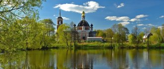
In 1876, using public funds, craftsmen from Moscow, with the participation of local craftsmen, began to erect a two-story, brick church with five domes. In 1889, the church opened its doors to parishioners.
The famous Kharabalin gardens brought wide fame to the village.
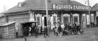
In 1926, the first electric light bulb appeared in Kharabali, and radio coverage of the village began. In 1927, the first collective farm “Iskra” was organized in the village of Kharabali. In 1930 - the collective farm "New Way" and the fishing collective farm "Red Catchers". In 1932, construction of a canning factory began in Kharabali, and in July 1936 it was put into operation.
In the period from the 30s and early 40s in the village. In Kharabali, the following buildings were built: secondary school No. 5, the building of the district executive committee, a party office, a village club, a cinema with 450 seats, a hospital with 35 beds, a park was planted in the center, a canteen, a library, an industrial plant, a food processing plant were operating [2]
In the late 1940s-1950s, mass landscaping of Kharabali began. In the mid-1950s, when the first water pipeline was laid, fruit trees were planted on the streets of Kharabalei.
In 1974, the village of Kharabali was transformed into a city of regional subordination. Kharabali becomes the center of agricultural and industrial production [1].
Map
| Kharabali: maps |
Kharabali: photo from space (Google Maps) Kharabali: photo from space (Microsoft Virtual Earth)
| Kharabali. Nearest cities. Distances in km. on the map (in brackets along roads) + direction. Using the hyperlink in the distance , you can get the route (information courtesy of the AutoTransInfo website) | |||
| 1 | Enotaevka | 24 (304) | SW |
| 2 | Sasykoli | 25 () | NW |
| 3 | Tsagan Aman (Republic of Kalmykia) | 43 (350) | NW |
| 4 | Nikolskoye | 74 (384) | NW |
| 5 | Narimanov | 91 (185) | SE |
| 6 | Verkhniy Baskunchak | 99 (175) | WITH |
| 7 | Black Yar | 111 (429) | NW |
| 8 | Akhtubinsk | 127 (135) | NW |
| 9 | Krasny Yar | 127 (223) | SE |
| 10 | Starokucherganovka | 131 () | SE |
| 11 | Astrakhan | 131 (158) | SE |
| 12 | Ilyinka | 138 () | YU |
| 13 | Nachalovo | 138 (171) | SE |
| 14 | Red Barricades | 140 () | YU |
a brief description of
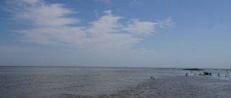
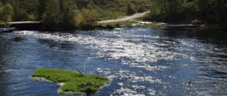
Located on the Caspian lowland, on the left bank of the river. Akhtuba (a branch of the Volga), 142 km northwest of Astrakhan. Railway station (Kharabalinskaya) on the Astrakhan - Saratov line.
Territory (sq. km): 1147
Information about the city of Kharabali on the Russian Wikipedia website
Historical sketch
Founded in 1770 as the village of Kharabalinskoye, later Kharabali. The name, apparently, represents a Kalmyk adaptation of the name of the Kazakh family Kara-Balasy, whose pastures were located in close proximity to the place where the village arose.
In the materials of the 1897 population census, it is mentioned as the village of Kharabalinskoye (Kharabali) in the Enotaevsky district of the Astrakhan province.
City since 1974
Municipal indicators
| Index | 2001 |
| Demography | |
| Number of births, per 1000 population | 10.9 |
| Number of deaths, per 1000 population | 14.2 |
| Natural increase (decrease), per 1000 population | -3.3 |
| Standard of living of the population and social sphere | |
| Average monthly nominal accrued wages, rub. | 1552 |
| Average housing area per inhabitant (at the end of the year), sq.m. | 16.8 |
| Number of preschool institutions, pcs. | 4 |
| Number of children in preschool institutions, thousand people | 0.6 |
| Number of daytime educational institutions (at the beginning of the school year), pcs. | 4 |
| Number of students in daytime educational institutions, thousand people | 3.1 |
| Number of doctors, people. | 78 |
| Number of nursing staff, people. | 222 |
| Number of hospital institutions, pcs. | 1 |
| Number of hospital beds, thousand units | 0.266 |
| Number of medical outpatient clinics, pcs. | 1 |
| Capacity of medical outpatient clinics, visits per shift, thousand units. | 0.9 |
| Number of registered crimes, pcs. | 345 |
| Persons who committed crimes were identified, persons. | 323 |
| Economy, industry | |
| Number of enterprises and organizations (at the end of the year), pcs. | 1075 |
| Construction | |
| Volume of work performed by type of activity “Construction” (until 2004 - volume of work performed under construction contracts), million rubles. | 37.4 |
| Commissioning of residential buildings, thousand sq.m. of total area | 3.2 |
| Commissioning of residential buildings, apartments | 41 |
| Commissioning of preschool institutions, places | 0 |
| Commissioning of educational institutions, places | 0 |
| Commissioning of hospital facilities, beds | 0 |
| Commissioning of outpatient clinics, visits per shift | 0 |
| Transport | |
| Number of bus routes (in intracity traffic), pcs. | 1 |
| Number of passengers transported by buses per year (in intracity traffic), million people. | 0.1 |
| Connection | |
| Number of residential telephone sets of the city public telephone network, thousand units. | 2.5 |
| Trade and services to the population | |
| Retail trade turnover (in actual prices), million rubles. | 335.2 |
| Retail trade turnover (in actual prices), per capita, rub. | 18023 |
| Public catering turnover (in actual prices), million rubles. | 1.7 |
| Volume of paid services to the population (in actual prices), million rubles. | 27.4 |
| Volume of paid services to the population (in actual prices), per capita, rub. | 1487 |
| Volume of household services to the population (in actual prices), million rubles. | 1.7 |
| Volume of household services to the population (in actual prices), per capita, rub. | 92 |
| Investments | |
| Investments in fixed assets (in actual prices), million rubles. | 14.1 |
| Share of investments in fixed assets financed from budgetary funds in the total volume of investments, % | 10.6 |
Data sources:
- Regions of Russia. Main characteristics of the constituent entities of the Russian Federation: statistical collection. Goskomstat of Russia. - M:, 2003.
Economy
In Kharabali: a vegetable canning plant, a mechanical forestry enterprise (industrial wood, wicker products - baskets, vases, lampshades, etc.), a brick factory.
Vegetables, melons and rice are grown in the Kharabala region. Sheep, camels and horses are raised.
Deposits of sand and clay.
Culture, science, education
Museum of History and Local Lore.
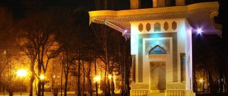
Architecture, sights
40 km south of Kharabali is an archaeological site of the 13th century. Sarai-Batu, the former capital of the Golden Horde.
70 km to the south is Kalmytsy Khurul (Buddhist monastery, built after 1812).
| Population by year (thousands of inhabitants) | |||||||
| 1897 | 3.5 | 1996 | 19.1 | 2007 | 18.1 | 2015 | 18.0 |
| 1939 | 8.3 | 1998 | 18.9 | 2008 | 18.1 | 2016 | 18.1 |
| 1959 | 9.7 | 2000 | 18.8 | 2010 | 18.1 | 2017 | 18.0 |
| 1970 | 14.3 | 2001 | 18.6 | 2011 | 18.1 | 2018 | 18.0 |
| 1979 | 17.0 | 2003 | 18.3 | 2012 | 18.2 | 2019 | 17.8 |
| 1989 | 18.6 | 2005 | 18.2 | 2013 | 18.3 | 2020 | 17.5 |
| 1992 | 18.7 | 2006 | 18.1 | 2014 | 18.1 | 2021 | 17.3 |
Other interesting sights of the Astrakhan region
There are several natural monuments within and outside the reserves that deserve special mention.
Dune "Big Brother"
- Coordinates: 46.430284, 47.492575.
The area in the west of the region is mostly deserted; here you can admire real sand dunes. The largest dune was called “Big Brother”.
It is believed that this name was given to him by the racers who regularly organize the “Kagan’s Gold” competition in the desert. The wind, like a sculptor, works with inspiration on the sand hill, constantly changing the shape and size of its creation. Only SUVs can drive through sandy terrain. The road to the dune is impassable, so getting to it on your own is almost impossible.
Tourists, as a rule, visit the attraction as part of an excursion group, using suitable transport and accompanied by an experienced guide.
Hillock Black
- Coordinates: 46.267990, 48.193641.
Cherny Hillock is the most famous of the Baer hillocks, named after the first explorer K. M. Baer. Cherny is one of the few hillocks in the Ilmenno-Bugrovy Nature Reserve that have escaped the harmful influence of humans.
Thanks to this, the natural monument has been preserved in its original form; such rare and amazingly beautiful plants as sand poppy, Bibirstein tulip, dwarf iris and others still grow on it.
Rollers and bee-eaters nest on the slopes of the hillock. In the fall of 1999, a worship cross was erected on the top of the hill, symbolizing the inviolability of Russian borders.
Hill of Snakes
- Coordinates: 46.350000, 48.716667.
10 kilometers from the village of Marfino there is a Botanical hillock, interesting from a botanical point of view, nicknamed Zmein. Zmeiny, together with the neighboring hillock Bolshoi Barfon and the surrounding territory, is protected by the state. In the mid-90s, this area of the landscape received the status of a natural monument.
Scientists became interested in the hillocks for a reason: Zmeiny is the only place in Russia where a very rare tropical plant, the Volga globulus, grows, whose homeland is considered to be the valley of the Tigris and Euphrates rivers. At the foot of the Great Barfon grows another endangered species - the water fern, or Marsilea Egyptian.
Baskunchak Cave
- Coordinates: 48.283056, 46.797222.
There are three dozen caves on the territory of the Bogdinsko-Baskunchaksky Nature Reserve. The largest of them, originating from the shore of Lake Baskunchak, pierces the ground to a depth of about 32 meters and has a total length of 1.5 kilometers.
The huge karst cave is considered the longest not only in the reserve, but in the entire territory of the Northern Caspian Sea. The cave is mostly dry, but there is a small freshwater lake inside.
The underground tunnel has three entrances; for many years they were considered separate caves. The cave has been known since the 19th century; inscriptions left by travelers back in 1874 are preserved on its walls.
The first serious study of the area was carried out in the 1940s by Saratov scientist A.D. Gedeonov. Over time, not only speleologists, but also ordinary tourists began to visit the cave. Today Baskunchakskaya is one of the most popular natural sites in the reserve.
Maly Zhemchuzhny Island
- Coordinates: 45.048611, 48.310000.
A small area of land in the Caspian Sea appeared on world maps relatively recently - in the 30s of the last century, when the level of the Caspian Sea fell. One of the shallows came to the surface and turned into an oblong island.
The area of the island is constantly changing, it reached its maximum size in the 70s, then its length was 10 kilometers and width - 400 meters. Over the past decades, the length has decreased three times.
Maly Zhemchuzhny became famous thanks to the large population of endemic Caspian seals, which chose the island as a rookery. At the beginning of spring and at the end of autumn, thousands of heavy carcasses wash up on the shores.
Also nesting on the land are endangered bird species such as the herring gull, black-headed gull and spotted tern. The fauna of the island attracts the attention of scientists from all over the world; famous film companies in Britain, France and other countries make documentaries about the natural monument.
Climate
- Average annual air temperature - 10.7 °C
- Relative air humidity - 59.1%
- Average wind speed - 3.9 m/s
| Average daily air temperature in Kharabali according to NASA[5] | ||||||||||||
| Jan | Feb | Mar | Apr | May | Jun | Jul | Aug | Sep | Oct | But I | Dec | Year |
| −4.3 °C | −4.0 °C | 2.0 °C | 11.8 °C | 19.2 °C | 24.4 °C | 26.9 °C | 24.7 °C | 18.3 °C | 10.6 °C | 1.7 °C | −3.4 °C | 10.7 °C |
Population
Population dynamics
| 1859[6] | 1897[7] | 1900[8] | 1904[9] | 1914[10] |
| 1938 | 2785 | 3478 | 3252 | 5502 |
| Population | ||||||
| 1897[11] | 1959 | 1970 | 1979[12] | 1989[13] | 1992[11] | 1996[11] |
| 3500 | ↗9700 | ↗14 300 | ↗17 043 | ↗18 566 | ↗18 700 | ↗19 100 |
| 1998[11] | 2000[11] | 2001[11] | 2002[14] | 2003[11] | 2005[11] | 2006[11] |
| ↘18 900 | ↘18 800 | ↘18 600 | ↘18 296 | ↗18 300 | ↘18 200 | ↘18 100 |
| 2007[11] | 2008[11] | 2009[15] | 2010[16] | 2011[11] | 2012[17] | 2013[18] |
| →18 100 | →18 100 | ↗18 117 | →18 117 | ↘18 100 | ↗18 178 | ↗18 275 |
| 2014[19] | 2015[20] | 2016[1] | ||||
| ↘18 146 | ↘18 041 | ↗18 097 | ||||