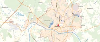
Kostroma is located on the banks of the Volga River. A map of Kostroma from a satellite will help you explore the city. Using a map, you can examine in detail the geographical location of a settlement and the access routes to it. In addition, the map will help you plan your trip and create convenient travel routes. Kostroma was founded in the 12th century. The city is one of the historical values of Russia and is included in excursion tours along the Golden Ring.
With the help of a detailed map of Kostroma, you can find any address in the city and not get lost.
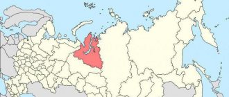
Where is Kostroma?
Kostroma is the administrative center of the Kostroma region, located on the Volga River.
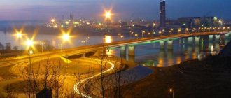
The city is located on the Kostroma Lowland, on the left and right banks of the Gorky Volga reservoir at the old mouth of the Kostroma River. The approximate population is 277 thousand people, the total area of the city is 144 square kilometers. The climate in Kostroma is temperate continental. The Atlantic Ocean has a huge moderating effect on the climate. The average annual air humidity in the city is 79%, the annual precipitation rate is 574 mm. The main rivers of Kostroma are the Volga and the left tributary of the Kostroma. The right bank of the Volga is steep and high; the left bank is low. The width of the Volga River in Kostroma is 600 m. Also within the city, small rivers flow into Kostroma and the Volga: Sula, Chernaya Rechka, Zaprudnya.
Kostroma is located in the same time zone as Moscow, the offset relative to Coordinated Universal Time (UTC) is +3.
Historical reference
The famous Volga city owes its existence to the son of Vladimir Monomakh - Prince Yuri Dolgoruky. The first mention of the settlement dates back to 1152. The Volga region lands were settled for the purpose of strategic strength and strengthening the princely possessions. The city and the area where Kostroma is located achieved its greatest prosperity during the reign of Vasily Yaroslavovich in the middle of the 13th century. The youngest son of Yaroslav Vsevolodovich declared the city the capital of his possessions, and a year later of all lands between the Volga and Oka.
Vasily made a huge contribution to the construction of religious shrines in the city. Under him, the Zaprudnensky Monastery, the Church of the Resurrection, and the Assumption Cathedral were founded. Expanding the territory of the Grand Duchy of Moscow, the stronghold city serves as an important defense against attacks by the Tatar army.
During the XII-XV centuries, a special place was given to the construction of defensive fortifications in the form of monasteries. Among such memorialized fortifications on the territory where Kostroma is located, the Ipatiev and Nikolo-Babaevsky monasteries stand out.
Kostroma had to go through difficult times when it was captured by Polish invaders. Only thanks to the people's militias of Minin and Pozharsky, the ancient city became Russian again.
At the end of the 18th century, Kostroma became a provincial city and a leader in the production of linen products - fabrics, oil and seeds.
Today, the settlement with a population of 277 thousand people is a major center of the textile and woodworking industries. The city of Kostroma, where the largest number of creative unions and organizations is located, has become the heart of folk festivals of folk art in Russia. It was in this ancient settlement that the history, traditions, rituals, clothing and crafts on which the great state developed and was built were preserved.
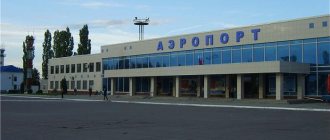
Kostroma Airport
In Kostroma there is an airport of federal significance "Sokerkino". Airport type - shared use, operating hours - from 4:00 to 13:00. Civil aircraft, as well as helicopters of the Russian Ministry of Defense, are based at the Sokerkino airfield.
Popular destinations of regular passenger flights: Simferopol, Voronezh, St. Petersburg, Lipetsk, Anapa. Passengers are transported on the An-26 aircraft by Russian airlines. The airport's annual passenger traffic is more than 7.4 thousand people.
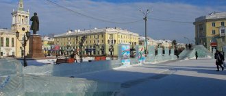
Attractions
The pearl of the city, its heart and calling card is the Ipatiev Monastery. For more than 300 years, the white-stone beauty has been storing the historical treasures of the Russian people. Among them are a unique wall painting by Kostroma icon painter Gury Nikitin, an ancient library with the Ipatiev Chronicle, and a gilded five-tiered iconostasis. Here on March 23, 1613, the election of Mikhail Romanov to the throne took place. It was the Kostroma monastery that became the cradle of the royal dynasty, and the Romanov revival began from its walls. Historical buildings have been preserved on the territory of the attraction - the Trinity Church, the chambers of the boyars, the cells of the monks, the holy gates, towers and buildings.
Where is Kostroma located, in what region of our vast Motherland can you still see so many churches that played an important role in the life of the locality? It is here, in the Volga region, that every piece of land is imbued with faith, history and love. God-protected and majestic - this is how the ancient city appears before tourists.
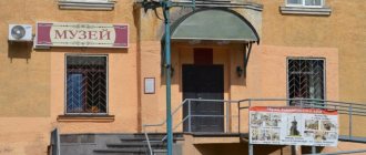
Among the modern attractions, tourists can visit the Flax and Birch Bark Museum. The halls display all types of work with plant material - from straw to shirts, from bark to baskets and bast shoes.
Train Station
The Kostroma-Novaya railway station is a freight railway station of the Yaroslavl region of the Northern Railway. The main railway station of the city and the station square are located on the territory of the station. The station is located at the junction of three streets: Volzhskaya, Nikitskaya, Titova. The station is located at pl. Shirokova, 1.
Popular long-distance train routes that run through the station: Yaroslavl, Moscow, Vladivostok. In summer, trains to St. Petersburg, Adler and Anapa run through the station. Also at the Kostroma-Novaya railway station there is service for commuter trains that go to Kosmynino, Galich, Nerekht, Yaroslavl.
Climatic conditions
The climate of the area where Kostroma is located has all the characteristics typical of the central Russian region of Russia. The summer season begins from mid-May and lasts until the end of August, pampering the townspeople with its temperature readings up to +30°C maximum and +22 (on average). Winters are cold and frosty. The air temperature drops to -30°C, and high humidity only makes the frost stronger. The coldest period occurs in January. Precipitation is a common occurrence in the area where Kostroma is located. Moist air masses from the Atlantic move freely across the flat territory, being the main reason for their abundance.
Automobile highways
Federal highways pass through Kostroma:
- M8 Kholmogory is a federal highway with a total length of 1,271 km. It is part of the European route E115. The route passes through the territory of the following regions of Russia: Yaroslavl region, Arkhangelsk region, Moscow region, Vladimir region. The road surface is asphalt.
- P243 is a federal highway that originates in Kostroma and passes through Kirov and Sharya. The total length of the R-243 route is 882 km. The road surface is asphalt concrete.
- P600 is a federal highway that connects the regional centers of Ivanovo and Kostroma. The total length of the route is 100 km. The road starts in Ivanovo and passes through Privolzhsk, Furmanov, Volgorechensk. The final point of the R-600 route is Kostroma. The road surface of the route is asphalt.
- 34H-3 - Public road of intermunicipal importance in the Kostroma region. The route runs from Kostroma to Nerekht. The total length of the road is 34 km.
What is Kostroma known for?
- In the city there is a Fire Tower - a historical monument built in the 19th century according to the design of P. Fursov. At this point in time, the building is part of the Kostroma historical and architectural reserve complex.
- Another monument of the 19th century that is located in Kostroma is the Guardhouse, located on Susaninskaya Square. The military-historical department of the city museum-reserve is located in the building of the Guardhouse.
- On Susaninskaya Square there is the Borschov House, a mansion built in the style of late classicism. The house was built in the 19th century, the author of the project was P. Fursov.
- In 1913, for the 300th anniversary of the Romanov dynasty, the Romanov Museum was built in Kostroma, which is an imitation of an ancient Russian tower. The museum exhibition includes the history of the Romanov family: important events in the life of the rulers, paintings, and objects of applied art.
- On Molochnaya Gora Street there is a nature museum of the Kostroma region. In this museum, tourists from all over the world can get acquainted with all the diversity of the nature of Kostroma and the region.
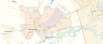
Map
| Kostroma: maps |
Kostroma: photo from space (Google Maps) Kostroma: photo from space (Microsoft Virtual Earth)
| Kostroma. Nearest cities. Distances in km. on the map (in brackets along roads) + direction. Using the hyperlink in the distance , you can get the route (information courtesy of the AutoTransInfo website) | |||
| 1 | Karavaevo | 8 () | SE |
| 2 | Nikolskoye | 10 () | NE |
| 3 | Krasnoe-on-Volga | 33 (35) | SE |
| 4 | Nekrasovskoe (Yaroslavl region) | 35 (36) | Z |
| 5 | Volgorechensk | 39 (43) | YU |
| 6 | Nerekhta | 40 (41) | SW |
| 7 | Sudislavl | 47 (50) | IN |
| 8 | Privolzhsk | 47 (53) | SE |
| 9 | Plyos | 48 (71) | SE |
| 10 | Susanino | 57 (61) | NE |
| 11 | Furmanov | 58 (72) | YU |
| 12 | Danilov | 64 (147) | NW |
| 13 | Yaroslavl | 65 (79) | Z |
| 14 | We love | 66 (158) | WITH |
| 15 | Navoloki | 69 (96) | SE |
| 16 | Ostrovskoye | 77 (83) | IN |
| 17 | Zavolzhsk | 78 (81) | SE |
| 18 | Konstantinovsky (Yaroslavl region) | 79 () | Z |
| 19 | Prechistoye (Yaroslavl region) | 80 (177) | NW |
| 20 | Kineshma | 80 (85) | SE |
| 21 | Gavrilov-Yam | 82 (112) | SW |
| 22 | Tutaev | 83 (119) | Z |
| 23 | Novo-Talitsy (Ivanovo region) | 84 () | YU |
| 24 | Vichuga | 84 (102) | SE |
| 25 | Ivanovo | 85 (100) | YU |
| 26 | Komsomolsk | 87 (96) | SW |
| 27 | Buoy | 87 (98) | NE |
| 28 | Springs | 88 (118) | SE |
| 29 | Kokhma | 93 (112) | YU |
| 30 | Semibratovo (Yaroslavl region) | 98 (104) | SW |
a brief description of
The city is located on the Kostroma Lowland, on the banks of the Volga River, 372 km northeast of Moscow.
Port on the river Volga. Railway station.
In 1970, Kostroma was included in the list of historical cities of Russia. The urban planning value of its heritage is assessed at the national level. Kostroma is included in the “Golden Ring of Russia” tourist route.
The climate is moderate continental. Average temperatures in January are -12, July are +18. Precipitation is about 600 mm per year.
Territory (sq. km): 145
Information about the city of Kostroma on the Russian Wikipedia website
Historical sketch
Founded in the 12th century. on the Volga, at the confluence of the river. Kostroma (from which it received its name) was first mentioned in the Resurrection and Tver Chronicles in 1213, when the Rostov prince Konstantin ravaged Kostroma. According to historian V. Tatishchev, the city was founded in 1152 during the expansion of Prince Yuri Dolgoruky in the Volga region.
The hydronym can be explained in two ways. According to one version, the presence of the final element -ma allows us to consider Kostroma, like neighboring Tolshma, Totma, Vokhtoma, etc., as a pre-Russian name of the Finno-Ugric type. However, the identification of the formant -ma is controversial in some cases, and the basis kostra- is atypical for the hydronymy of this region. Therefore, modern researchers are returning to the opinion of the Slavic origin of this name. In Russian mythology, Kostroma personified fertility and spring. In the “farewell to spring” ritual, the funeral ritual of Kostroma was performed in the form of her straw effigy. The mythological name is based on the Slavic kostra “bast, fiber” or the dialect kostroma “twigs, straw, weeds”.
From the middle of the 13th century. center of the Kostroma appanage principality as part of the Vladimir-Suzdal principality, in 1272-76. was the residence of the Grand Duke. Since 1362, part of the Moscow state.
From the beginning of the 13th to the end of the 17th centuries. Kostroma was repeatedly ravaged by the Tatars, Novgorod ushkuiniki, Polish-Lithuanian troops, etc. In 1375 it was ravaged by the Novgorod ushkuiniki, who sailed here along the Volga. At the beginning of the 14th century. Kostroma supported the Tver prince Mikhail against the Moscow prince Yuri in the struggle for the great reign and was defeated in 1318.
In the 14th century the city was fortified. In 1413 and 1493 Kostroma was devastated by severe fires, after the first of which a new fortress was founded on the high left bank. In 1471 and 1478 The Kostroma army took part in the campaigns of Ivan III against Novgorod.
In the 1540s Kostroma was attacked three times by the Kazan Tatars; in 1549 they were defeated by the Kostroma militia on the Yazovka River.
Kostroma was closely connected with the Godunov family and then played a significant role in the accession of the new Romanov dynasty in Russia. In 1609, supporters of False Dmitry II captured the Ipatiev Monastery, which protected the approaches to the city, and turned it into a support base for military operations in the northeast of the country. The Kostroma militia expelled the rebels and joined the people's militia K.M. Minin and D.M. Pozharsky played a significant role in the fight against Polish intervention. The feat of the Kostroma peasant Ivan Susanin has become legendary.
In the 17th-18th centuries. Kostroma is one of the large Russian cities with developed textile and metalworking industries. According to the census of 1650, there were 2,086 households in Kostroma.
In 1708 the city of the Moscow province, from 1719 the center of the Kostroma province. Since 1778, the center of the Kostroma governorship (since 1796 - Kostroma province).
In the 18th-19th centuries. Kostroma is an industrial center. The first linen manufactory was founded in 1751.
In 1856, in the provincial city of Kostroma, Kostroma province, there were 41 churches, 1,620 houses, 372 shops.
In 1913, city celebrations took place in honor of the visit of Emperor Nicholas II to Kostroma.
Since 1944 - the center of the Kostroma region.
In 1994, the urban districts of Dimitrovsky, Leninsky and Sverdlovsky were abolished.
Municipal indicators
| Index | 1990 | 1999 | 2001 | 2003 | 2005 |
| Demography | |||||
| Number of births, per 1000 population | 12 | 7.5 | 8.5 | 9.7 | 10.1 |
| Number of deaths, per 1000 population | 11.1 | 15.4 | 17.4 | 19.5 | 18.3 |
| Natural increase (decrease), per 1000 population | 0.9 | -7.9 | -8.9 | -9.8 | -8.2 |
| Standard of living of the population and social sphere | |||||
| Average monthly nominal accrued wages, rub. | 0.262 | 1311.3 | 2549.4 | 4507 | 6896.9 |
| Average housing area per inhabitant (at the end of the year), sq.m. | 16.8 | 19 | 19.5 | 20.9 | 21.5 |
| Number of preschool institutions, pcs. | 139 | 98 | 89 | 86 | 86 |
| Number of children in preschool institutions, thousand people | 19.7 | 10.7 | 10.1 | 10.3 | 11.3 |
| Enrollment of children in preschool educational institutions (at the end of the year), as a percentage of the number of children of the corresponding age, % | 80 | 79.5 | |||
| Number of daytime educational institutions (at the beginning of the school year), pcs. | 44 | 50 | 50 | 49 | 47 |
| Number of students in daytime educational institutions, thousand people | 35.6 | 36.4 | 33.5 | 29.7 | 25.9 |
| Number of doctors, people. | 1620 | 1625 | 1551 | 1515 | 1519 |
| Number of nursing staff, people. | 3743 | 4056 | 3839 | 3785 | 3732 |
| Number of hospital institutions, pcs. | 14 | 12 | 11 | 12 | 13 |
| Number of hospital beds, thousand units | 4.6 | 4 | 4.2 | 4.2 | 4.3 |
| Number of medical outpatient clinics, pcs. | 30 | 35 | 35 | 43 | 58 |
| Capacity of medical outpatient clinics, visits per shift, thousand units. | 5.3 | 5.7 | 5.3 | 5.6 | 5.8 |
| Number of registered crimes, pcs. | 3380 | 8840 | 10986 | 8218 | 9495 |
| Persons who committed crimes were identified, persons. | 2741 | 2071 | 1615 | 1770 | |
| Economy, industry | |||||
| Number of enterprises and organizations (at the end of the year), pcs. | 5934 | 6596 | 7404 | 8885 | |
| Number of operating enterprises by type of activity: mining (at the end of the year), pcs. | 4 | ||||
| Number of operating enterprises by type of activity: manufacturing (at the end of the year), pcs. | 212 | ||||
| Number of operating enterprises by type of activity production and distribution of electricity, gas and water (at the end of the year), pcs. | 70 | ||||
| Volume of shipped goods of own production by type of mining (in actual prices), million rubles. | 36.6 | ||||
| Volume of shipped goods of own production by type of manufacturing (in actual prices), million rubles. | 11150.1 | ||||
| Volume of shipped goods of own production by type of production and distribution of electricity, gas and water (in actual current prices), million rubles. | 4814.6 | ||||
| Construction | |||||
| Volume of work performed by type of activity “Construction” (until 2004 - volume of work performed under construction contracts), million rubles. | 0.127 | 640.6 | 1066.6 | 1607.5 | 1003.1 |
| Commissioning of residential buildings, thousand sq.m. of total area | 133.4 | 90.2 | 132.8 | 68.6 | 54.8 |
| Commissioning of residential buildings, apartments | 2354 | 1450 | 1988 | 816 | 752 |
| Commissioning of preschool institutions, places | 0 | 0 | 0 | 0 | 0 |
| Commissioning of educational institutions, places | 2592 | 0 | 0 | 0 | 0 |
| Commissioning of hospital facilities, beds | 80 | 0 | 0 | 0 | 0 |
| Commissioning of outpatient clinics, visits per shift | 30 | 0 | 25 | 0 | 0 |
| Transport | |||||
| Number of bus routes (in intracity traffic), pcs. | 28 | 31 | 38 | 30 | 21 |
| Number of trolleybus routes, pcs. | 7 | 6 | 6 | 6 | 6 |
| Length of operational trolleybus lines (at the end of the year), km | 28.4 | 29.7 | 29.7 | ||
| Number of passengers transported by buses per year (in intracity traffic), million people. | 77.5 | 124.1 | 131.2 | 101.3 | 58.1 |
| Number of passengers transported by trolleybuses per year, million people. | 49 | 46.4 | 54.3 | 41.7 | 41.6 |
| Connection | |||||
| Number of telephone sets of the city public telephone network, thousand units. | 42.2 | 68.4 | 78.1 | 89.2 | 101.1 |
| Number of residential telephone sets of the city public telephone network, thousand units. | 24.3 | 53.4 | 61.1 | 70.9 | 79.1 |
| Number of payphones of the city telephone network (including universal ones), pcs. | 451 | 343 | |||
| Trade and services to the population | |||||
| Retail trade turnover (in actual prices), million rubles. | 2615.5 | 4433.8 | 6749.1 | 10000.2 | |
| Retail trade turnover (in actual prices), per capita, rub. | 9059 | 15427 | 24286 | 36335 | |
| Index of physical volume of retail trade turnover, % compared to the previous year | 108 | 102.4 | |||
| Index of physical volume of public catering turnover, % compared to the previous year | 108.5 | 112.3 | |||
| Number of stores, pavilions (at the end of the year), pcs. | 61 | 31 | |||
| Sales area of shops, pavilions (at the end of the year), sq.m. | 9019.9 | 4128.9 | |||
| Volume of paid services to the population (in actual prices), million rubles. | 0.134 | 595.1 | 1162.4 | 2183.4 | 4125.6 |
| Volume of paid services to the population (in actual prices), per capita, rub. | 0.4 | 2061.3 | 4044.6 | 7856.7 | 14991.2 |
| Volume of household services to the population (in actual prices), million rubles. | 0.035 | 99.3 | 163.4 | 213.6 | 280.8 |
| Volume of household services to the population (in actual prices), per capita, rub. | 0.116 | 344.1 | 568.5 | 768.7 | 1020.4 |
| Investments | |||||
| Investments in fixed assets (in actual prices), million rubles. | 0.307 | 568.2 | 1768.4 | 1748.8 | 3324.3 |
| Share of investments in fixed assets financed from budgetary funds in the total volume of investments, % | 33.3 | 35.1 | 25.6 | 14.4 | |
Data sources:
- Regions of Russia. Main characteristics of the constituent entities of the Russian Federation: statistical collection. Goskomstat of Russia. - M:, 2003.
- Regions of Russia. Basic socio-economic indicators of cities. Statistical collection. Rosstat. - M:, 2005. p. 43
- Transport in Russia: Statistical collection. Goskomstat. - M:, 2003. pp. 112, 122
- Transport in Russia: Statistical collection. Rosstat. - M:, 2005. pp. 119, 129
- Regions of Russia. Basic socio-economic indicators of cities. 2006. Statistical collection. Rosstat. - M:, 2006. p. 43
Culture, science, education
Kostroma State Technological University, Kostroma State Agricultural Academy, Kostroma State Pedagogical University.
Drama Theater.
Historical and architectural museum-reserve, museum of fine arts.
In the village of Karavaevo there is the Kostroma Agricultural Academy (the Kostroma breed of meat and dairy cows was bred here).
Universities of the city
Military Academy of Radiation, Chemical and Biological Defense named after.
Marshal of the Soviet Union S.K. Timoshenko 156015, Kostroma, st. Gorky, 1
Kostroma State Technological University
156005, Kostroma, st. Dzerzhinsky, 17 WWW: https://www.kstu.edu.ru/
Kostroma State University named after. ON THE. Nekrasova
156000, Kostroma, st. May 1, 14 WWW: https://ksu.edu.ru/
Kostroma branch of the Modern Humanitarian Academy
156013, Kostroma, st. Lenina, 20
Russian State Humanitarian University (Kostroma branch)
156000, Kostroma, st. Sverdlova, 36
Museums, galleries, exhibition halls
Kostroma State Historical, Architectural and Art Museum-Reserve 156000, Kostroma, Mira Ave., 7 Telephone(s): inquir.
ex.bureau Website: https://www.kostromamuseum.ru/ Museum of Nature of the Kostroma Region 156000, Kostroma, Kostroma, st. Molochnaya Gora, 3 Phone(s) Website: https://www.km-priroda.ru/
Museum of Jewelry Art 156000, Kostroma, st. Sovetskaya, 7 Phone(s) Website: https://museum.ametist-kostroma.ru/
Municipal Art Gallery of Kostroma 156013, Kostroma, pl. Mira, 2 Phone(s): (4942) 51-6445
Architecture, sights
The central part of the city is an integral urban planning ensemble that arose in the late 18th and early 19th centuries. on the site of the old center, demolished earthen and wooden fortifications of the Kremlin and the New Town (17th century) as a result of development according to the regular master plan of 1781-84. 7 radial rays, covered by semirings of transverse streets, converge on the central square located near the river.
In the northern corner of the square there is a high pyramidal fire tower (1823-26, the top was rebuilt in 1880). The ensemble of the square is completed by 2 symmetrically located buildings of former shopping arcades, from the north - Bolshie Muchnye (1789-93), from the south - Red (1789-1800), surrounded by arcades on powerful 4-sided pillars.
In place of the Kremlin there is a city park, with terraces going down to the Volga. At the end of one of them - the so-called. Ostrovsky's gazebo (erected in 1956 according to models of park structures of the 18th-19th centuries).
The blocks adjacent to the central square are built with stone former merchant mansions of the late 18th - early 19th centuries. according to standard projects. On the central city street is the former Assembly of the Nobility, originally a merchant mansion of the 18th century.
In the north-west of the central part of the city is the Epiphany Monastery (founded in the 15th century) with the five-domed Epiphany Cathedral (1559-65), stone chambers of the 17th century. Not far from the embankment is the elegant five-domed Church of the Resurrection on Debra (1652, interior frescoes from the 17th century, carved gilded iconostasis from the 17th century). In the eastern part of the city there is the Church of St. John Chrysostom (1791, built in the traditions of the 17th century) with a three-tier bell tower.
Opposite the center, across the Kostroma River, is the Ipatiev Monastery (founded at the beginning of the 14th century), which includes stone fortress walls and round corner towers (16-17th centuries). On the territory of the monastery there is the Trinity Cathedral (1650-52) with a belfry (1603-05). 3-storey Bishop's (16-17 centuries) and fraternal (16-18 centuries) buildings, near the western fortress wall - the so-called. chambers of the Romanov boyars (16th-17th centuries, restored in 1863). Outside the walls of the monastery, to the south of it is the Museum of Wooden Architecture (churches of the 16th-17th centuries, huts, windmills of the 19th century).
Opposite the central part of Kostroma, in the Trans-Volga region, on the right bank of the Volga, there is the Nativity Church (Ilyinskaya on Gorodishche, 1663, rebuilt in 1702, 1773), the Transfiguration Church with a hipped bell tower (1685, the top was rebuilt).
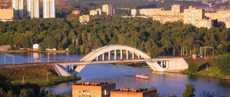
In the modern city, the old buildings of the center are largely preserved. Large residential construction is underway in the Volga region, with which it is connected by a bridge (1970s), as well as in the southeastern part of the city.
| Population by year (thousands of inhabitants) | |||||||
| 1811 | 10.1 | 1959 | 171.7 | 1996 | 285.9 | 2012 | 269.3 |
| 1840 | 13.5 | 1962 | 189 | 1998 | 289.4 | 2013 | 271.4 |
| 1856 | 14.8 | 1967 | 209 | 2000 | 288.1 | 2014 | 273.4 |
| 1863 | 21.4 | 1970 | 223.0 | 2001 | 287.9 | 2015 | 276.1 |
| 1897 | 41.3 | 1973 | 236 | 2003 | 278.8 | 2016 | 276.7 |
| 1914 | 68.7 | 1976 | 247 | 2005 | 275.9 | 2017 | 277.6 |
| 1923 | 59.2 | 1979 | 254.7 | 2006 | 274.5 | 2018 | 277.3 |
| 1926 | 72.3 | 1982 | 262 | 2007 | 273.4 | 2019 | 276.1 |
| 1931 | 87.6 | 1986 | 273 | 2008 | 271.7 | 2020 | 276.9 |
| 1939 | 121.3 | 1989 | 278.4 | 2010 | 269.7 | 2021 | 277.4 |
| 1956 | 156 | 1992 | 282 | 2011 | 268.7 | ||
Literature
- Krogius V.R.
Historical cities of Russia as a phenomenon of its cultural heritage. M.: Progress-Tradition, 2009. pp. 183-186 - Pospelov E.M.
Geographical names of the world: Toponymic dictionary: About 5000 units. M.: Russian dictionaries, Astrel Publishing House LLC, AST Publishing House LLC, 2001. pp. 217-218 - Ch.
ed. Gorkin A.P. Geography of Russia: encyclopedic dictionary. M.: Great Russian Encyclopedia, 1998. pp. 284-285 - Ch.
ed. Lappo G.M. Cities of Russia: encyclopedia. M.: Great Russian Encyclopedia, 1994. pp. 210-213