Map of Kaluga, Kaluga region. Characteristics of the city
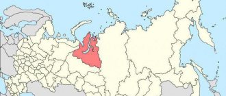
Kaluga is a city in the Central Federal District. It is the administrative center of the Kaluga region. The online map of Kaluga shows that the center of Moscow is 160 km away.
The city of Kaluga is mentioned in the charters of the Lithuanian prince Olgerd dated 1371. This is considered the date of the founding of the settlement, but many scientists argue that the settlement has a much more ancient history. Be that as it may, Kaluga appeared on the map of Russia only in 1389. It was during this period that its territory became part of the Moscow Principality. At the end of the 14th century, Kaluga was a guard outpost, a reliable barrier on the way of the Tatar-Mongols and other foreigners.
For 13 years from 1505 to 1518. the city had the status of an appanage principality until in 1587 and 1595 it again had to become a fortified city. During these years, he defended Moscow from the attacks of the Crimean Tatars. In 1719 Kaluga acquired a new status. It is designated the center of the Kaluga province. Today the city is considered one of the largest in Russia. Its territory area is 168.8 km2. At the end of 2022, over 340,000 people lived here.
Flag
The flag of Kaluga is made in the form of a rectangular panel. The ratio of its sides is 2:3. On the left is a red vertical stripe 1/3 the length of the flag with an image of a satellite at the top. It is turned towards the shaft. The rest of the area is occupied by two blue horizontal stripes, one of which depicts the historical crown and a wavy white one between them. The ratio of the width of the stripes (in the case of blue ones, indicated by the largest width) is 3:2:3.
The flag was approved on January 25, 2000. Included in the State Heraldic Register of the Russian Federation under No. 588.
Kaluga on the map of Russia: geography, nature and climate
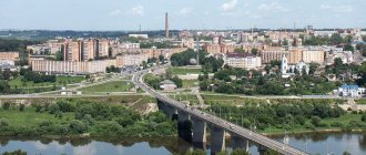
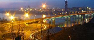
The city of Kaluga is located on the Central Russian Upland, located on the left bank of the river. Oka and its tributaries: Kievka, Kaluzhka, Yachenka and Tereptsa. On the territory of the city there is a large Yachenskoye reservoir, which influences the climate of the surrounding areas.
Climate
The city itself is located in a temperate continental climate zone. The seasons are clearly visible here. A moderately cold winter does not frighten you with severe frosts. The average temperature in January is from -100C to -80C. Summers are warm and humid, but pleasant. Due to the large number of water arteries, the heat is easily tolerated. The average temperature in July is from +190C to +250C. This warm weather often continues until the very end of September.
Flora and fauna
The map of the city of Kaluga shows that coniferous-deciduous and broad-leaved forests predominate in the city. The flora is represented by more than 1,000 species of plants: birch, aspen, various types of horsetails and ferns, spruce, etc. Bream and roach, perch and pike are found in the city’s reservoirs. And the fauna is represented by Western European, steppe and northern species of animals: fox, elk, wild boar, hare, etc.
City information
Kaluga is the administrative center of the municipality and region of the same name. Located in the west of the Russian Federation. It is located on the banks of the Oka River and its tributary – Yachenka. The economy is represented by enterprises in the military, engineering, and food industries. There are automobile factories.
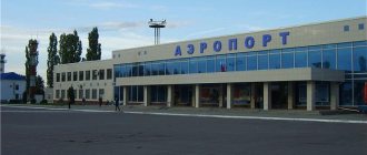
The M3 “Ukraine” highway passes near the settlement. There is a railway service connecting with major cities. There is a civil airport "Grabtsevo". There are universities and their branches, secondary specialized educational institutions. The population is more than 340 thousand people.
Map of the city of Kaluga with roads. Transport infrastructure
The municipality is a large-scale transport hub. If you look at a map of Kaluga from a satellite, you can see that four major highways pass near the city:
- R 92 - crosses the territory of the settlement in the south. Tula Highway exits onto R 92, which is located perpendicular to the R 132 highway;
- R 132 - connects Kaluga and Tula;
- Highway R 93 “Medyn-Kondorovo-Kaluga” is a large regional road. Length 60 km;
- Highway E 101 (M 3) “Moscow-Kaluga-Bryansk” is a 500-kilometer route connecting the capital of Russia with the border of Ukraine.
Residents of the city are served by public transport, represented by buses, minibuses and trolleybuses. There are 68 bus routes in Kaluga. At the end of 2015, the fleet of minibus taxis was updated. There are 15 trolleybus routes. Also in the city there are:
- Kaluga International Airport - restored in 2015;
- Railway station "Kaluga-1" - opened in 1874.
- Azarova Railway Station;
- Railway station "Kaluga-2" - Kiev direction, opened in 1959.
- Perspektivnaya Railway Station;
- The bus station is located in the same building as the Kaluga-1 railway station.
Bus service is provided with the suburbs and intercity.
Average salary by profession
The minimum salary in settlements of the Kaluga region is 11,280 rubles. The average monthly (nominal) is 41,204. In reality, Kaluga residents on average earn almost 30 thousand rubles per month.
Salary indicators in the most popular areas of employment in Kaluga
The city is actively constructing new residential complexes. In this regard, the most popular industries are construction and real estate.
You can find out about salaries in Russia by region by following the link.
The most popular industries in which residents are employed
| Industry | Salary (thousand rubles per month) |
| Construction | 48 |
| Transport | 46,7 |
| Agriculture | 45,6 |
| Production | 45,7 |
| Top management | 43 |
| Show Business | 41 |
| Medicine | 40 |
| Real estate | 36,7 |
| Engineering | 36 |
| 34,3 |
average salary
| Period | Average salary (thousand rubles per month) |
| June 2020 | 25,9 |
| July 2020 | 26 |
| August 2020 | 29,2 |
| September 2020 | 27,7 |
| October 2020 | 32 |
| November 2020 | 30,7 |
| December 2020 | 30,8 |
| January 2021 | 31,6 |
| February 2021 | 30 |
| March 2021 | 32,7 |
The highest demand in the city is for drivers of various categories and secretaries.
The most in-demand professions in 2022
Demand for professions as a percentage
| Profession | Number of vacancies |
| Driver | 447 |
| Secretary in the office | 261 |
| Process engineer | 231 |
| Salesman-cashier | 185 |
| Internet manager | 164 |
| Store manager | 115 |
| HR specialist | 112 |
| Taxi driver | 107 |
| Online store manager | 102 |
More information about the labor market in Russia.
Top 10 paid professions
| Profession | Average salary (thousand rubles per month) | |
| 1 | Welder | 97 |
| 2 | Sewing equipment adjuster | 83 |
| 3 | Argon welder | 81 |
| 4 | Relay controller | 80 |
| 5 | Electrical fitter | 74 |
| 6 | Minibus driver | 72,5 |
| 7 | Carousel turner | 70 |
| 8 | Driver category E | 70 |
| 9 | Machine operator/setter | 66,8 |
| 10 | CNC operator | 66,8 |
How much does a doctor earn?
A doctor in Kaluga earns about 40 thousand rubles a month.
Average income of doctors in 2020-2021.
| Period | Average salary (thousand rubles per month) |
| June 2018 | 40 |
| July 2018 | 40 |
| August 2018 | 40 |
| September 2018 | 45 |
| October 2018 | 45 |
| November 2018 | 45 |
| December 2018 | 45 |
| January 2019 | 45 |
| February 2019 | 50 |
| March 2019 | 50 |
How much does a teacher earn?
The average salary of a teacher is about 16 thousand rubles per month.
Average teacher salary
| Period | Average salary (thousand rubles per month) |
| June 2018 | 17 |
| July 2018 | 16 |
| August 2018 | 18 |
| September 2018 | 18 |
| October 2018 | 18 |
| November 2018 | 14,5 |
| December 2018 | 13 |
| February 2019 | 20 |
| March 2019 | 20 |
Find out more about teacher salaries in Russia.
How much does the seller get?
The average salary of a salesperson is about 22 thousand rubles per month.
Average salesperson salary
| Period | Average salary (thousand rubles per month) |
| June 2018 | 22 |
| July 2018 | 22,1 |
| August 2018 | 23 |
| September 2018 | 22 |
| October 2018 | 22 |
| November 2018 | 22 |
| December 2018 | 20 |
| January 2019 | 22 |
| February 2019 | 23 |
| March 2019 | 23 |
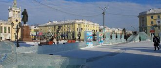
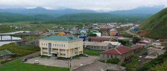
Sights of the city of Kaluga
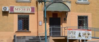
Kaluga is a historical city. Every tourist will find a lot of interesting places and exciting sights. Among the main museums:
- House-Museum of K.E. Tsiolkovsky . The founder of rocket science lived and worked in this building. The furnishings and all the personal belongings of the scientist were preserved in the house. Address on the map of Kaluga: st. Tsiolkovsky, 79;
- Zolotarev estate on the street. Pushkina, 14. It is also a local history museum. The building where the museum is located is itself a striking monument of classicism from 1775. The museum presents a huge number of exhibitions;
- Chizhevsky House-Museum on the street. Moskovskaya, 62. A mini observatory has been equipped, exhibitions illustrating the life path of the famous biophysicist are presented;
- Kaluga Regional Art Museum on the street. Lenina, 104. Personal art collections of famous figures of Kaluga are presented here.
These are just the most popular and largest museums in the city. Tired of viewing the exhibitions, you can sit on cozy benches in the Central Recreation Park of Kaluga. It is located on the square. Stary Torg, 4. The uniqueness of the place is in the exotic and rare green spaces. Here you can see perennial oaks, blue spruces, Weymouth pines, Siberian firs and other plants.
Among the equally interesting places of interest:
- Planetarium on the street Ak. Koroleva, 2. Projections of the starry sky and space are shown here using the most modern German equipment;
- Sculpture “Bag of Happiness” on the street. Theater. The beautiful and unusual sculpture was donated to the city by a banking institution;
- Chambers of Korobov merchants on the street. Plekhanova, 88. The merchant's house was built in a unique architectural style.
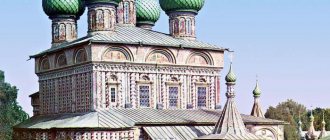
When visiting Kaluga, you should definitely see the Church of the Intercession of the Blessed Virgin Mary “on the moat” and the Temple of Cosmas and Damian . As well as the Gostiny Dvor of 14 chambers and the Museum of Crafts and Life .
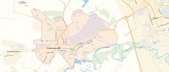
Territorial structure of Kaluga
Officially, the settlement is divided into three districts - Oktyabrsky , Leninsky and Moskovsky . Each of them, if you look at the map of Kaluga with streets and houses, is divided into several districts:
- Cuba is the northernmost microdistrict with five-story Khrushchev buildings;
- Baikonur is Kubyaka's neighbor. The area was built for space industry workers. Nowadays veterans live here;
- Raduzhny is a new microdistrict being built with comfortable housing;
- Severny is a microdistrict adjacent to the ring road. Farthest from the center;
- Bushma - on the map of Kaluga it is located in the eastern part of the city. A more modern area where the regional psychiatric clinic is located;
- Typhoon is a microdistrict built in 1980. It is considered the most comfortable for living. Located in the east of Kaluga;
- Malinniki is the most unsuitable for living and the oldest microdistrict. Located in the northeastern part. There is an industrial zone and a turbine plant here;
- Silicate - located in the north-west of Kaluga. The area is well connected to the city center and has good housing;
- Podzavalie - built on the hills. The private sector is mainly located here;
- The right bank is the most developing area of the city. A beautiful residential complex “Pravgorod” is being built here;
- Terepets is a young microdistrict. Construction began in 1985. Located in a forested area;
- Annenki is an area built for medical workers. Located in Kaluga Bor.
The list shows large microdistricts of the city. But there are also smaller ones: Dubrava, Sereda and Turynino.
The Saints
- St. Tikhon of Kaluga and Medyn (+ 1492)
- blzh. Lavrenty Kaluga (+ 1515), Fool for Christ's sake
- sschmch. Augustine (Belyaev), archbishop. Kaluzhsky (+ 1937), executed in Kaluga
- prmch. Ioannikiy (Dmitriev), archimandrite. (+ 1937), shot in Kaluga
- prmch. Seraphim (Gushchin), priest. (+ 1937), shot in Kaluga
- sschmch. Georgy Izvekov, prot (+ 1937), born in Kaluga
- sschmch. John of Speransky, Archpriest (+ 1937), shot in Kaluga
- sschmch. Sergius Orlov, priest. (+ 1937, commemorated December 8), served in Kaluga villages, shot at the Kaluga training ground
- martyr Alexy Gorbachev (+ 1937), executed in Kaluga
- martyr Apollo Babichev (+ 1937), native of Kaluga, executed in Kaluga
- martyr Mikhail Arefiev (+ 1937), native of Kaluga, executed in Kaluga
- mts. Anna Ostroglazova (+ after 1937), born in Kaluga
- martyr Nikolai Smirnov (+ not earlier than 1937), psalmist of St. George's Cathedral in 1922-1937.
- mts. Olga Maslennikova (+ 1941), born in Kaluga
- mts. Feoktista Chentsova (+ 1942), born in Kaluga
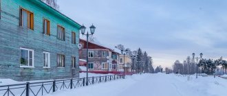
Map of Kaluga with streets and houses
Looking at the street map of Kaluga, you don’t notice any small streets. It seems that the whole city is cut up by long large avenues and streets. There are an unusually large number of significant city arteries here. Among them:
- st. Lenin
- st. Nikitina
- st. Moscow
- st. Tula
- st. Stepan Razin
- st. Lunacharsky
It will be difficult to get lost. Kaluga has a very convenient and simple layout of the territory.
Economy and industry of Kaluga
Kaluga is an economically developed city. There are large Russian enterprises here that produce products in the field of metalworking, automobile and mechanical engineering, and electric power. The light food industry is also developed here. There are large factories producing building materials in the city. The most significant enterprises for the city:
- Kaluzhsky;
- Kaluga Bread Factory (since 1936);
- Kaluga turbine;
- ;
- JSC "Autoelectronics";
- Kaluga Electromechanical Plant and many others.
There are more than 10 large shopping centers and 8 markets in the city. There are hypermarkets and business centers.