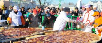
Where to go from Yekaterinburg for the weekend? In response to this question, we offer our TOP best routes for the whole family starting from Yekaterinburg. All routes were compiled by real Experts of the Urals who have already experienced them themselves. For each route, we have prepared a map and GPS coordinates of places that you must visit in the Sverdlovsk region.
If these routes suddenly aren’t enough for you, then we invite you to familiarize yourself with our list of attractions in the Sverdlovsk region , as well as an interactive map of the Urals , where you can see the distance from the capital of the Urals .
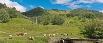
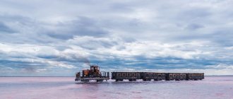
Based on the hike to the Suhogorsk stone
After a very long break, having sat at home, we again happened to return to the mountains... We just went to the Sukhogorsky (Kazan) Stone - the highest point of the Sukhogorsk ridge, and only 1200 meters high, but that was enough to start again weaving a chain of hikes and travel, which has not been interrupted to this day, having already taken someone to the Pamir-Alay, the Fan Mountains, and someone to the Caucasus, to storm Elbrus... ... Find out more
Satellite cities of Yekaterinburg.
Berezovsky
The city was built near a gold mine and there have never been any hazardous industries here. In addition to good ecology, multi-apartment high-rise and low-rise brick buildings are built here, which is a rarity today. Geographically, the city borders the Shartash district. However, territorial proximity does not affect the time spent traveling to the center of Yekaterinburg. There are no large factories with hazardous production in Berezovsky. The city is surrounded by pine trees. Clean water and fresh air are a big advantage over other satellite cities and we recommend buying an apartment in Berezovsky.
Upper Pyshma
The driver of the city's development is the UMMC company, which invests in the construction of housing and social facilities. The disadvantages of the city are relatively high housing prices (closest to housing prices in Yekaterinburg in the Uralmash and Elmash districts) and not the most favorable environmental situation.
At the moment, enterprises in the field of non-ferrous metallurgy, metalworking, mechanical engineering and the chemical industry are concentrated in Verkhnyaya Pyshma. According to experts, high concentrations of a wide range of heavy metals - copper, zinc, mercury, lead, arsenic, cadmium - are observed in the upper layers of the soil.
Aramil
This is the smallest settlement in our ranking. This city is called promising, but so far “unpromoted”. In terms of infrastructure (besides educational), there are only grocery stores here. The development is represented by the private sector, nine- and three-story buildings. Aramili has the lowest prices for apartments.
There are no large industrial productions in Aramil. The settlement is surrounded by a forested park area, creating a barrier to pollutants and smog in Yekaterinburg.
Sredneuralsk
The settlement was formed in connection with the start of construction of the Sredneuralsk State Regional Power Plant (SuGRES). Sredneuralsk is home to a small number of residents; the quality and quantity of infrastructure leave much to be desired. The prices for apartments cannot be called “provincial”. The environmental situation is influenced by the city-forming enterprise.
The oldest cities in the Sverdlovsk region
The first cities on the territory of the modern Sverdlovsk region appeared at the turn of the 16th-17th centuries, long before Yekaterinburg. But it was inhabited long before the names of today's cities appeared. Numerous sites of ancient man have been found here, the appearance of which is dated from the Paleolithic to the Iron Age.
Verkhoturye, 1598. Founded in 1598 by the expedition of Vasily Golovin and Ivan Voeikov as a permanent protected point, which later became the main fortress on the way to Siberia. Verkhoturye is today both the oldest and one of the smallest cities in the Sverdlovsk region.
Turinsk, 1600. The settlement appeared on January 30 (February 9), 1600 as a fort on the site of the ancient settlement of Epanchin (Epanchin-Yurt) destroyed by Ermak. Its appearance is associated with the Babinovskaya road, built in 1597 from Solikamsk to the upper reaches of the Tura. A protected settlement between Verkhoturye and Tyumen served to guard the waterway to Siberia.
Irbit, 1631. The oldest settlements in these places date back to the second millennium BC (Bronze Age); modern Irbit is located almost on the site of the Irbit settlement, located on a hill near the northwestern outskirts of the city. It is believed that the ancestors of the Mansi lived here until the 13th century. In 1631, at the confluence of the Irbit River and Nitsa, a fort was founded.
Stone city. Perm region
Stone City is one of the main natural attractions of the Perm region. This is a truly unique natural monument, located on the main peak of the Rudyansky Spoy ridge. This place got its name for a reason. Bizarre rock outcrops form a real city: with streets, avenues, and dead ends. It seems that you are wandering through an ancient, abandoned city.
There are many other attractions near the Stone Town: Usva Pillars, geologists' caves, the abandoned village of Yubileiny, abandoned coal mines in Usva, so it is better to plan your trip for two days.
More details
general information
GPS coordinates: N 58° 43'20″; E 57° 37'59″ From Yekaterinburg to Kamenny Town 400 km. We spent about 6 hours on the road, stopping a couple of times to stretch our legs and drink coffee. From Usva to the parking lot from which the route begins - 9 km. From the parking lot to the Stone Town - 1.5 km. Where to stay: Chalet legend - tel Tourist transfer - Usva-Gromovaya-Shumikhinsky-Kamenny Gorod - 8 912 484 61 73
Kazan. Republic of Tatarstan
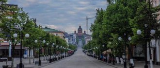
Kazan is the capital of Tatarstan. And the third capital of Russia with a thousand-year history, which attracts tourists from Yekaterinburg with simple logistics of the way there/back.
A symbiosis of Eastern and Western culture, religion, mentality. You should set aside at least a day to visit the ancient Kremlin of the 12th century with its palaces, temples, museum and one of the largest mosques in Europe.
Be sure to take a walk along Bauman (a pedestrian street, similar to Arbat). Try chak-chak and echpochmak.
More details
general information
From Yekaterinburg to Kazan 1100 km. The most convenient train in time is train 139Н (Novosibirsk-Adler), which departs from Yekaterinburg at 18.19 local time and arrives in Kazan at 6 am. Time in Kazan is Moscow, that is, it differs from ours by 2 hours.
Kirovgrad is the leader in the ranking of the smallest in area
The smallest town in size is ancient Kirovgrad: its area is only 10 km². It is believed that Kirovgrad grew out of the small village of Kalatay, which appeared in 1661. However, the official date of formation of the city is considered to be 1808, since it was then that the audit documented its existence. Soon, rich deposits of copper ore and small gold deposits were discovered nearby. During their development, it was possible to obtain a significant archaeological find - the famous Shigir idol. Made from larch during the Mesolithic era, the sculpture is considered the oldest surviving one in the world: its age is about 11,000 years.
Kirovgrad is also known as the birthplace of Russian non-ferrous metallurgy: it was here, at the Kalatinsky copper smelter built in 1914, that the first refined copper in the USSR was produced. However, the deposits were quickly depleted, and by 1941 the plant was mothballed. Before this, in 1932, the settlement received city status, and three years later received a new name: in honor of the famous revolutionary Sergei Kirov, the town was renamed Kirovgrad.
Train Station
The Yekaterinburg-Passenger station is the main passenger transport hub of the city, located on the main route of the famous Trans-Siberian Railway (Transsib). The station serves more than 115 thousand passengers per day, which puts it in third place in terms of passenger traffic among Russian stations (after Moscow and St. Petersburg).
From the Ekaterinburg railway station there are direct flights to many Russian cities and cities in Central Asia - Astana, Tashkent, Bishkek, etc. Also from the Yekaterinburg-Passenger station you can take a direct flight to Berlin, Warsaw, Gomel, Grodno, Pyongyang, Erdenet and other international destinations.
In addition to the passenger station, there is an auxiliary cargo station "Shartash" in Yekaterinburg, from which passenger flights depart to some nearby cities, including Bogdanovich, Kamensk-Uralsk and Artyomovsk.
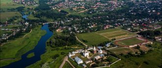
Dalmatovsky Monastery. Kurgan region
The ensemble of the Dalmatovsky Monastery is a historical and cultural monument of federal significance. The founding date is considered to be 1644, when the monk Dalmat, a resident of the Nevyansk Epiphany Monastery in Verkhoturye, settled in a cave on the high bank of the Iset River.
The ensemble of the Dalmatovsky Monastery is a historical and cultural monument of federal significance. To date, the following have been restored: the Church of Sorrows, the chapel-tomb of St. Dalmatus, the gateway Ionic Theological Church, the chapel in front of the entrance to the monastery, the northern cells (now there is a museum here).
The Dalmatovo Monastery was a center of spiritual enlightenment and education in Siberia. Among the students of the Dalmatov School was the inventor of radio A.S. Popov, home teacher M.Yu. Lermontov, poet, professor of literature A.F. Merzlyakov, famous Trans-Ural local historian, archaeologist, writer A. N. Zyryanov, geographer, polar explorer K.D. Nosilov.
More details
Metro
The Yekaterinburg metro is small, it has only one line with 9 stations. The construction of the metro began only in the late 80s; due to the crisis, the stations were put into operation at a slow pace in the 90s, the last one was built relatively recently - in 2012. Currently, 2 branches (27 stations) are in the design stage. However, the Ekaterinburg metro ranks 4th in Russia in terms of passenger traffic (after the Moscow, St. Petersburg and Novosibirsk metro), serving about 170 thousand passengers daily, or about 49.3 million per year (data for 2022).
Nevyansk - bears the title of the first factory city in history
In second position in the ranking of small towns is Nevyansk, whose area is 17 km². It owes its appearance to Peter the Great, who in 1701 ordered the construction of an iron and iron smelting plant in the Urals. Due to the fact that the settlement began to form around the built enterprise, Nevyansk can be called the first factory city in world history. Also, its development is connected with another famous person: businessman Nikita Demidovich Antufiev. The emperor taught him a lesson in managing the new plant, not suspecting that soon the enterprising Nikita would achieve unprecedented heights, becoming the founder of the Demidov family.
The current city limits were recorded in 2006, when the population was 25,600. In Nevyansk and the neighboring town of Cementnoye there are five large factories operating in the following areas:
- mechanical engineering;
- pipe processing;
- cement production;
- production of dry mixtures.
In addition, the small town is considered a cultural center of Old Believer icon painting of the mining type. The most famous landmark is the Ural Leaning Tower of Nevyansk, built in 1721 as a family building of the Demidovs, marking their receipt of the title of nobility. Scientists are still debating whether something went wrong during construction, or as a result of subsequent flooding of the basements, but the tower tilted 3° 16′ at its greatest point. The structure is a symbol of the city and was even minted on a commemorative coin of the Central Bank in 2007.
Automobile highways
Six federal highways pass through Yekaterinburg simultaneously, which is due to the city’s favorable geographical location between the European and Asian parts of Russia:
- P242 (Novomoskovsky tract) is a highway to Perm, adjacent to the city from the west.
- P351 is a highway to Tyumen in the eastern part of the city, turning into a backup of the Siberian Highway.
- P352 (Serovsky tract) - the road to Nizhny Tagil, then to Serov, adjoins the city from the north-west.
- P354 is a highway to Shadrinsk, then to Kurgan, it adjoins from the east and also turns into a backup of the Siberian Highway.
- P355 (Polevskoy tract) - road on Polevskaya, adjacent from the southwest.
Also, roads to Rezh (Rzhevsky Tract, adjacent to the EKAD - Yekaterinburg Ring Road) and Chusovskoye Lake (Chusovsky Tract) pass through Yekaterinburg, but they are not included in the list of federal highways.
The highway to Chelyabinsk is part of the AH7 route of the Asian international network. The route begins in Yekaterinburg and ends on the Indian Ocean coast in Karachi, passing through six (not counting Russia) states - Kazakhstan, Kyrgyzstan, Uzbekistan, Tajikistan, Afghanistan and Pakistan.
Map
| Ekaterinburg: maps |
Yekaterinburg: photo from space (Google Maps) Yekaterinburg: photo from space (Microsoft Virtual Earth)
| Ekaterinburg. Nearest cities. Distances in km. on the map (in brackets along roads) + direction. Using the hyperlink in the distance , you can get the route (information courtesy of the AutoTransInfo website) | |||
| 1 | Upper Pyshma | 14 (23) | WITH |
| 2 | Berezovsky | 15 (16) | NE |
| 3 | Mountain Shield | 16 () | YU |
| 4 | Big Source | 17 () | SE |
| 5 | Sredneuralsk | 18 (17) | NW |
| 6 | Source | 19 () | IN |
| 7 | Aramil | 21 (15) | SE |
| 8 | Verkhneye Dubrovo | 29 () | IN |
| 9 | Bobrovsky | 29 (31) | SE |
| 10 | Monetary | 31 (37) | NE |
| 11 | Degtyarsk | 32 (74) | SW |
| 12 | Sysert | 39 (44) | YU |
| 13 | Pervouralsk | 39 (48) | Z |
| 14 | Revda | 40 (48) | Z |
| 15 | Zarechny | 44 (66) | IN |
| 16 | Bilimbay | 47 (61) | Z |
| 17 | Polevskoy | 49 (56) | SW |
| 18 | Beloyarsky | 50 (58) | IN |
| 19 | Novouralsk | 55 (75) | NW |
| 20 | Asbestos | 56 (82) | IN |
| 21 | Malysheva | 58 (97) | NE |
| 22 | Novoutkinsk | 64 (85) | Z |
| 23 | Verkhniye Sergi | 65 (109) | Z |
| 24 | Reftinsky | 72 (104) | IN |
| 25 | Verkhniy Tagil | 72 (82) | NW |
| 26 | Kirovgrad | 73 (87) | NW |
| 27 | Nevyansk | 75 (92) | WITH |
| 28 | Cement | 76 () | WITH |
| 29 | Dir | 77 (88) | NE |
| 30 | Nizhniye Sergi | 80 (109) | Z |
a brief description of
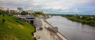
Located on the eastern slope of the Middle Urals along the banks of the river. Iset (tributary of the Tobol), 1667 km east of Moscow.
The climate is continental. The average temperature in January is -18, in July +19. Precipitation is 500 mm per year.
Large transport hub. Latitudinal and meridional railways and roads converge in Yekaterinburg. Metropolitan.
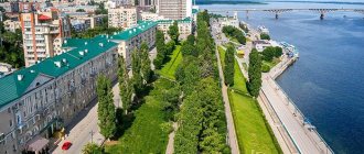
Yekaterinburg is a large industrial center of Russia, the scientific and cultural center of the Urals.
Territory (sq. km): 1143
Information about the city of Yekaterinburg on the Russian Wikipedia site
Historical sketch
The city was founded in 1721 by V.N. Tatishchev as a mining, cultural and trade center of the Urals.
The official founding date is November 7 (18), 1723, when the first stage of the State Metallurgical Plant on the river came into operation. Iset and widespread urban construction began. The Isetsky plant and the fortress attached to it were soon named Yekaterinburg in honor of the wife of Emperor Peter I, Ekaterina Alekseevna (1684-1727).
The Ural Mining Administration and the Mining School were located in Yekaterinburg. Near the city, the Verkh-Isetsky and Verkhneuktussky (Elizavetinsky) metallurgical plants were built, which later merged with Yekaterinburg.
In 1735, a mint was established where copper coins were minted. In the 18th century In Yekaterinburg, a stone processing industry arose (in 1751 a lapidary factory was built to produce vases, boxes and other products from malachite and porphyry). In 1763, the Siberian Highway was built from Moscow through Yekaterinburg to Siberia.
Since 1781, Yekaterinburg has been the center of the Yekaterinburg region of the Perm governorate, since 1796 it has been a district city of the Perm province.
Yekaterinburg played a big role in the creation of the gold mining industry in Russia. Gold ores mined in the surrounding mines were smelted here.
Since the 1840s Yekaterinburg became a center of metalworking, and from the end of the 19th century. - an important railway center of the Urals (in 1878 it was connected by railway with Perm).
The first printing house opened in the city in 1803, and a hospital in 1832. The Mining Museum was founded in 1834, and the observatory in 1836. A professional theater began operating in 1843. In 1869, the Ural Society of Natural Sciences was founded.
In 1856, in the mining district city of Yekaterinburg, Perm province, there were 9 churches, 2925 houses, 316 shops.
On October 26 (November 8), 1917, Soviet power was established in the city. On the night of July 17-18, 1918, the former Russian Emperor Nicholas II and his family were shot in Yekaterinburg. On July 25, 1918, the city was captured by the Czechoslovaks during the mutiny of the Czechoslovak Corps. Released as a result of the Yekaterinburg operation in July 1919.
By the beginning of the 20th century. Yekaterinburg is one of the largest district cities in the European part of Russia. Since 1919 the center of the Yekaterinburg province, since 1923 - the Ural region. In 1924-91. was called Sverdlovsk (after the name of the Soviet party and statesman Y.M. Sverdlov (1885-1919)). Since 1934 the center of the Sverdlovsk region.
Since the 1930s Large factories were built in the city, mainly machine-building and metalworking.
The city included the villages of Nizhne-Isetsky (PGT from 08/27/1928, 3.4 thousand inhabitants, 1931), Uktus (PGT from 08/27/1928, 3.0 thousand inhabitants, 1931).
Municipal indicators
| Index | 1990 | 1999 | 2001 | 2003 | 2005 |
| Demography | |||||
| Number of births, per 1000 population | 11.7 | 7.7 | 8.9 | 10.1 | 10 |
| Number of deaths, per 1000 population | 10 | 13.8 | 14.4 | 14.4 | 13.6 |
| Natural increase (decrease), per 1000 population | 1.7 | -6.1 | -5.5 | -4.3 | -3.6 |
| Standard of living of the population and social sphere | |||||
| Average monthly nominal accrued wages, rub. | 0.31 | 1707 | 3644 | 6494 | 9887 |
| Average housing area per inhabitant (at the end of the year), sq.m. | 15.3 | 19.3 | 19.7 | 19.6 | 20.3 |
| Number of preschool institutions, pcs. | 629 | 336 | 314 | 286 | 294 |
| Number of children in preschool institutions, thousand people | 90.6 | 34.8 | 35.1 | 36.1 | 37.9 |
| Enrollment of children in preschool educational institutions (at the end of the year), as a percentage of the number of children of the corresponding age, % | 58.5 | 57.8 | |||
| Number of daytime educational institutions (at the beginning of the school year), pcs. | 178 | 238 | 232 | 233 | 227 |
| Number of students in daytime educational institutions, thousand people | 163.7 | 177.2 | 161.7 | 143.4 | 125 |
| Number of doctors, people. | 9893 | 11039 | 10850 | 11047 | 10967 |
| Number of nursing staff, people. | 18021 | 17010 | 16089 | 16582 | 17664 |
| Number of hospital institutions, pcs. | 54 | 64 | 61 | 55 | 52 |
| Number of hospital beds, thousand units | 22.7 | 19 | 18.8 | 18.5 | 18.6 |
| Number of medical outpatient clinics, pcs. | 142 | 224 | 251 | 254 | 256 |
| Capacity of medical outpatient clinics, visits per shift, thousand units. | 35.6 | 37.6 | 40.1 | 32.1 | 32.4 |
| Number of registered crimes, pcs. | 27129 | 36997 | 42493 | 41780 | 60642 |
| Persons who committed crimes were identified, persons. | 13658 | 15588 | 15176 | 11243 | 11119 |
| Economy, industry | |||||
| Number of enterprises and organizations (at the end of the year), pcs. | 54958 | 70375 | 89307 | 115149 | |
| Number of operating enterprises by type of activity: mining (at the end of the year), pcs. | 12 | ||||
| Number of operating enterprises by type of activity: manufacturing (at the end of the year), pcs. | 542 | ||||
| Number of operating enterprises by type of activity production and distribution of electricity, gas and water (at the end of the year), pcs. | 156 | ||||
| Volume of shipped goods of own production by type of mining (in actual prices), million rubles. | 461.3 | ||||
| Volume of shipped goods of own production by type of manufacturing (in actual prices), million rubles. | 73517.2 | ||||
| Volume of shipped goods of own production by type of production and distribution of electricity, gas and water (in actual current prices), million rubles. | 26958.9 | ||||
| Construction | |||||
| Volume of work performed by type of activity “Construction” (until 2004 - volume of work performed under construction contracts), million rubles. | 0.569 | 1823 | 3649 | 2748.4 | 13340.9 |
| Commissioning of residential buildings, thousand sq.m. of total area | 605.6 | 307.9 | 310.8 | 412.8 | 643.1 |
| Commissioning of residential buildings, apartments | 3490 | 3318 | 4618 | 8359 | |
| Commissioning of preschool institutions, places | 1954 | 0 | 0 | 0 | 0 |
| Commissioning of educational institutions, places | 5724 | 0 | 0 | 0 | 0 |
| Commissioning of hospital facilities, beds | 250 | 630 | 0 | 180 | 62 |
| Commissioning of outpatient clinics, visits per shift | 1910 | 50 | 0 | 0 | 870 |
| Transport | |||||
| Number of metro stations, pcs. | 7 | 7 | |||
| Operating length of metro tracks, km | 0 | 7 | 8 | ||
| Number of bus routes (in intracity traffic), pcs. | 62 | 52 | 51 | 42 | |
| Number of tram routes, pcs. | 31 | 29 | 28 | 27 | 28 |
| Length of operational tram tracks (at the end of the year), km | 77.2 | 78.9 | 78.8 | ||
| Number of trolleybus routes, pcs. | 17 | 18 | 18 | 18 | 18 |
| Length of operational trolleybus lines (at the end of the year), km | 59.4 | 77 | 76.4 | ||
| Number of passengers transported by metro per year, million people. | 0 | 31 | 40.1 | 43.6 | |
| Number of passengers transported by buses per year (in intracity traffic), million people. | 317.5 | 272.9 | 265.5 | 238 | 145.2 |
| Number of passengers transported by trams per year, million people. | 245.6 | 224.5 | 225.9 | 244.9 | 202.2 |
| Number of passengers transported by trolleybuses per year, million people. | 113.7 | 141.5 | 135 | 131.5 | 95.5 |
| Connection | |||||
| Number of telephone sets of the city public telephone network, thousand units. | 195.6 | 411.1 | 449.9 | 514.6 | 557.6 |
| Number of residential telephone sets of the city public telephone network, thousand units. | 161.3 | 277.4 | 298 | 342.2 | 390.7 |
| Number of payphones of the city telephone network (including universal ones), pcs. | 3857 | 3872 | |||
| Trade and services to the population | |||||
| Retail trade turnover (in actual prices), million rubles. | 25360 | 48147 | 82296 | 154814.7 | |
| Retail trade turnover (in actual prices), per capita, rub. | 19266 | 36931 | 63940 | 115749.3 | |
| Index of physical volume of retail trade turnover, % compared to the previous year | 114.9 | 127.2 | |||
| Index of physical volume of public catering turnover, % compared to the previous year | 126.1 | 122.9 | |||
| Number of stores, pavilions (at the end of the year), pcs. | 349 | 376 | |||
| Sales area of shops, pavilions (at the end of the year), sq.m. | 76983 | 114380 | |||
| Volume of paid services to the population (in actual prices), million rubles. | 0.3 | 3638 | 10199 | 20891 | 36318 |
| Volume of paid services to the population (in actual prices), per capita, rub. | 0.2 | 2764 | 7823 | 15626 | 27153.7 |
| Volume of household services to the population (in actual prices), million rubles. | 0.102 | 382.9 | 804.7 | 1271.2 | 3512 |
| Volume of household services to the population (in actual prices), per capita, rub. | 0.076 | 290.9 | 617.3 | 950.8 | 2625.8 |
| Investments | |||||
| Investments in fixed assets (in actual prices), million rubles. | 0.713 | 3900 | 8752 | 13680 | 23809.1 |
| Share of investments in fixed assets financed from budgetary funds in the total volume of investments, % | 41.1 | 18.3 | 25.7 | 18.3 | 18 |
Data sources:
- Regions of Russia. Main characteristics of the constituent entities of the Russian Federation: statistical collection. Goskomstat of Russia. - M:, 2003.
- Regions of Russia. Basic socio-economic indicators of cities. Statistical collection. Rosstat. - M:, 2005. p. 269
- Transport in Russia: Statistical collection. Goskomstat. - M:, 2003. pp. 110, 112, 114, 120, 122, 123
- Transport in Russia: Statistical collection. Rosstat. - M:, 2005. pp. 117, 119, 121, 127, 129
- Regions of Russia. Basic socio-economic indicators of cities. 2006. Statistical collection. Rosstat. - M:, 2006. p. 265
Culture, science, education
There are about 140 research, design and design institutes and organizations in the city. Ural Center RAS. Ural State University.
Institutes: polytechnic, mining, architectural, medical, pedagogical, agricultural, electromechanical, railway transport engineers, legal, forestry, etc. Conservatory.
Theaters: opera and ballet named after A.V. Lunacharsky, dramatic, musical comedy, young spectators, puppets.
Philharmonic. Circus.
Museums: regional local history museum, Ural Mountains museum, literary museum named after D.N. Mamin-Sibiryak, House-Museum of P.P. Bazhova. Art gallery (founded in 1936 - the largest collection of works of Kasli casting, including the unique Kasli cast-iron pavilion, which received a gold medal at the World Exhibition in Paris in 1900). Museum of the History of Medicine, Museum of Military Glory of the Urals and History of the Ural Military District.
Architecture, sights
Yekaterinburg extends from west to east for 15 km, from north to south for 26 km. The Iset River, dividing the city into western and eastern parts, has been turned into a system of stepped reservoirs (the largest is Verkh-Isetsky pond, the others are Gorodskoy, Parkovy and Nizhneisetsky).
In Yekaterinburg there are numerous buildings from the 18th - early 19th centuries. in the style of classicism: the Mining Chancellery (1737-39, rebuilt in 1833-35 according to the design of the architect M.P. Malakhov), the former estate of Rastorguev-Kharitonov (1794-1824, architect Malakhov), Malakhov’s house (1817-20), etc. .
On the site of a metallurgical plant built in 1723, a Historical Square with blocks of rocks from different regions of the Ural region was created.
Since the second half of the 1920s, reconstruction and new construction were carried out in the city. Large buildings appeared in the constructivist style: “House of Offices” (1930, architect V.I. Smirnov), the residential complex “Chekist Town” (1931, architects I.P. Antonov, V.D. Sokolov, etc.), Vtuzgorodok complex (1929-30). Since 1959, the construction of large-block and large-panel residential buildings has been underway. According to the general plan approved in 1972, the center is developing along the river. Iset.
| Population by year (thousands of inhabitants) | |||||||
| 1856 | 16.9 | 1967 | 961 | 1998 | 1274.4 | 2012 | 1377.7 |
| 1897 | 43.2 | 1970 | 1025.0 | 2000 | 1266.3 | 2013 | 1396.1 |
| 1913 | 53.5 | 1973 | 1099 | 2001 | 1259.1 | 2014 | 1412.3 |
| 1923 | 97.4 | 1976 | 1163 | 2003 | 1293.5 | 2015 | 1428.0 |
| 1926 | 133.8 | 1979 | 1211.2 | 2005 | 1304.3 | 2016 | 1444.4 |
| 1931 | 223.3 | 1982 | 1252 | 2006 | 1308.4 | 2017 | 1455.5 |
| 1939 | 425.5 | 1986 | 1315 | 2007 | 1315.1 | 2018 | 1468.8 |
| 1956 | 707 | 1989 | 1364.6 | 2008 | 1323.0 | 2019 | 1483.1 |
| 1959 | 778.6 | 1992 | 1304 | 2010 | 1343.8 | 2020 | 1493.7 |
| 1962 | 853 | 1996 | 1277.8 | 2011 | 1349.8 | 2021 | 1495.1 |