District in the Republic of Kalmykia, Russia
| Gorodovikovsky district Gorodovikovsky district | |
| District | |
| Other transcription(s) | |
| • Kalmyk | Bashtan district |
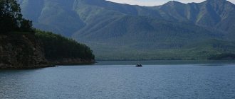
| Khagin-Sala river near Village from Vesely in Gorodovikovsky district | |
| Location of Gorodovikovsky district of the Republic of Kalmykia. | |
| Coordinates: 46°05'N 41°56'E / 46.083°N 41.933°E / 46,083; 41.933 Coordinates: 46°05'N 41°56'E. / 46.083°N 41.933°E / 46,083; 41,933 | |
| A country | Russia |
| Federal subject | Republic of Kalmykia [1] |
| Established | 1920 [1] |
| Administrative center | Gorodovikovsk [1] |
| Square [1] | |
| • General | 1,099.05 km 2 (424.35 sq mi) |
| population size (2010 Census) [2] | |
| • General | 17 295 |
| • Evaluate (2018) [3] | 15 533 ( -10,2% ) |
| • Density | 16/km2 (41/sq mi) |
| • Urban | 55,3% |
| • Rural | 44,7% |
| Administrative structure | |
| • Administrative division | 1 town, 6 rural administrations |
| • Settlements [1] | 1 Cities/towns, 18 rural localities |
| Municipal structure | |
| • Municipally registered as | Gorodovikovsky municipal district [4] |
| • Municipalities [4] | 1 Urban settlements, 6 Rural settlements |
| Timezone | UTC+3 (MSK[5]) |
| OKTMO ID | 85605000 |
| Web site | https://agrmo.rk08.ru |
Population of Gorodovikovsky district.
| 2010 Census | 17 295 [2] |
| 2002 Census | 19 322 [6] |
| 1989 Census | 20 895 [7] |
| 1979 Census | 20 922 [8] |
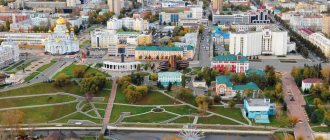
Gorodovikovsky district
(Russian: Gorodovikovskiy raion; Kalmyk: Bashntan rayon,
Bashntansky district
) is an administrative [1] and municipal [4] district (rayon), one of thirteen in the Republic of Kalmykia, Russia. It is located in the west of the republic. The area of the district is 1,099.05 square kilometers (424.35 sq mi). [1] Its administrative center is the city of Gorodovikovsk. [1] Starting from the 2010 census, the total population of the district was 17,295 people, of which the population of Gorodovikovsk was 55.3%. [2]
Administrative and municipal status[edit]
According to administrative division, Gorodovikovsky district is one of thirteen in the Republic of Kalmykia. [1] It is divided into one city (an administrative division with the administrative center in the city (locality) Gorodovikovsk) and six rural administrations, which include eighteen rural localities. [1] As a municipal entity, the district is included in the Gorodovikovsky municipal district
. [4]Gorodovikovsk is included as an urban settlement, and six rural administrations are included as six rural settlements within the municipal district. [4] The city of Gorodovikovsk is the administrative center of both the administrative [1] and municipal [4] district.
Map
| Gorodovikovsk: maps |
Gorodovikovsk: photo from space (Google Maps) Gorodovikovsk: photo from space (Microsoft Virtual Earth)
| Gorodovikovsk. Nearest cities. Distances in km. on the map (in brackets along roads) + direction. Using the hyperlink in the distance , you can get the route (information courtesy of the AutoTransInfo website) | |||
| 1 | Yashalta | 38 (133) | NE |
| 2 | Krasnogvardeyskoe (Stavropol Territory) | 41 (91) | SW |
| 3 | Safe (Stavropol Territory) | 48 (83) | IN |
| 4 | Razvilnoe (Rostov region) | 51 (99) | Z |
| 5 | Salsk | 54 (64) | NW |
| 6 | Ptichye (Stavropol Territory) | 64 () | YU |
| 7 | Giant (Rostov region) | 65 () | NW |
| 8 | Peschanokopskoe (Rostov region) | 66 (116) | Z |
| 9 | Trunovskoye (Stavropol Territory) | 68 () | YU |
| 10 | Donskoye (Stavropol Territory) | 70 (108) | YU |
| 11 | Proletarsk | 70 (98) | WITH |
| 12 | Abundant | 81 (131) | YU |
| 13 | White Clay (Krasnodar region) | 82 (151) | IN |
| 14 | Novotroitskaya (Stavropol Territory) | 84 () | YU |
| 15 | Novoaleksandrovsk | 84 (139) | SW |
| 16 | Ipatovo | 85 (103) | SE |
| 17 | Tselina (Rostov region) | 85 (109) | NW |
| 18 | Kugulta (Stavropol Territory) | 87 () | SE |
| 19 | Orlovsky (Rostov region) | 87 (130) | WITH |
| 20 | Moskovskoye (Stavropol Territory) | 88 (122) | YU |
| 21 | Rashevatskaya (Stavropol Territory) | 89 () | SW |
| 22 | Blagodatnoe (Stavropol Territory) | 91 () | SE |
| 23 | Ryzdvyany (Stavropol Territory) | 91 (149) | YU |
| 24 | Solnechnodolsk (Stavropol Territory) | 93 (155) | YU |
| 25 | Novopokrovskaya (Krasnodar region) | 96 (171) | Z |
| 26 | Pelagiada (Stavropol Territory) | 98 () | YU |
| 27 | Konstantinovskoe (Stavropol Territory) | 102 () | SE |
| 28 | Grachevka (Stavropol Territory) | 104 (197) | YU |
| 29 | Verkhnerusskoe (Stavropol Territory) | 105 () | YU |
| 30 | Mikhailovsk | 105 (173) | YU |
a brief description of
Located on the Kuma-Manych depression, on the river. Bashantenon, 60 km from the railway. Salsk station, 240 km west of Elista
Territory (sq. km): 152
Information about the city of Gorodovikovsk on the Russian Wikipedia site
Historical sketch
Founded in 1872 as the Kalmyk settlement of Bashanta (Mongolian baishin "house").
Since 1909, the administrative center of the Bolshederbetovsky (from 1930 Western) ulus. Since 1938, the working village of Bashanta.
The city of Gorodovikovsk has been named after the Soviet military leader Hero of the Soviet Union O.I. since 1971. Gorodovikov (1879-1960).
Municipal indicators
| Index | 2001 |
| Demography | |
| Number of births, per 1000 population | 12 |
| Number of deaths, per 1000 population | 16.2 |
| Natural increase (decrease), per 1000 population | -4.2 |
| Standard of living of the population and social sphere | |
| Average monthly nominal accrued wages, rub. | 1407 |
| Average housing area per inhabitant (at the end of the year), sq.m. | 19.5 |
| Number of preschool institutions, pcs. | 5 |
| Number of children in preschool institutions, thousand people | 0.3 |
| Number of daytime educational institutions (at the beginning of the school year), pcs. | 5 |
| Number of students in daytime educational institutions, thousand people | 1.9 |
| Number of doctors, people. | 35 |
| Number of nursing staff, people. | 105 |
| Number of hospital institutions, pcs. | 1 |
| Number of hospital beds, thousand units | 0.1 |
| Number of medical outpatient clinics, pcs. | 1 |
| Capacity of medical outpatient clinics, visits per shift, thousand units. | 0.2 |
| Number of registered crimes, pcs. | 230 |
| Persons who committed crimes were identified, persons. | 277 |
| Economy, industry | |
| Number of enterprises and organizations (at the end of the year), pcs. | 350 |
| Construction | |
| Volume of work performed by type of activity “Construction” (until 2004 - volume of work performed under construction contracts), million rubles. | 101.9 |
| Commissioning of residential buildings, thousand sq.m. of total area | 2.9 |
| Commissioning of residential buildings, apartments | 38 |
| Commissioning of preschool institutions, places | 0 |
| Commissioning of educational institutions, places | 0 |
| Commissioning of hospital facilities, beds | 0 |
| Commissioning of outpatient clinics, visits per shift | 0 |
| Transport | |
| Number of bus routes (in intracity traffic), pcs. | 1 |
| Number of passengers transported by buses per year (in intracity traffic), million people. | 7.7 |
| Connection | |
| Number of residential telephone sets of the city public telephone network, thousand units. | 1.7 |
| Trade and services to the population | |
| Retail trade turnover (in actual prices), million rubles. | 2.1 |
| Retail trade turnover (in actual prices), per capita, rub. | 206 |
| Public catering turnover (in actual prices), million rubles. | 178 |
| Volume of paid services to the population (in actual prices), million rubles. | 16.6 |
| Volume of paid services to the population (in actual prices), per capita, rub. | 1627 |
| Volume of household services to the population (in actual prices), million rubles. | 0.2 |
| Volume of household services to the population (in actual prices), per capita, rub. | 20 |
| Investments | |
| Investments in fixed assets (in actual prices), million rubles. | 7.4 |
| Share of investments in fixed assets financed from budgetary funds in the total volume of investments, % | 28.4 |
Data sources:
- Regions of Russia. Main characteristics of the constituent entities of the Russian Federation: statistical collection. Goskomstat of Russia. - M:, 2003.
Economy
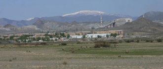
Brick, canning, butter factories. Meat processing plant, folk crafts plant, etc.
In the Gorodovikovsky district, wheat, barley, buckwheat, sunflower, corn, vegetables, and melons are grown. They raise cattle, pigs, sheep, goats, and horses.
Deposits of natural gas, brick clay, gypsum, fresh water.
Main enterprises
PLANT CULTIVATION
Agricultural production cooperative "New Life"
359000, Republic of Kalmykia, Gorodovikovsky district, Gorodovikovsk,
Offers:
Crop production
Museums, galleries, exhibition halls
Gorodovikovsky Museum of Local Lore 359050, Republic of Kalmykia, Gorodovikovsky district, Gorodovikovsk, st. Lenina, 13 Phone(s): (231) 9-1909 Website: https://www.museum.kalm.ru/
Architecture, sights
The water tower (1909, height 38 m) has been preserved.
A natural monument is the Bashanta oak grove (the first trees were planted in 1887).
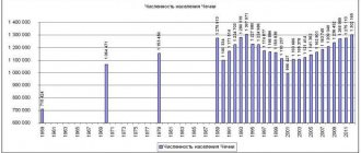
| Population by year (thousands of inhabitants) | |||||||
| 1939 | 4.0 | 1998 | 10.5 | 2008 | 9.8 | 2016 | 8.8 |
| 1959 | 4.6 | 2000 | 10.3 | 2010 | 9.5 | 2017 | 8.8 |
| 1970 | 7.8 | 2001 | 10.0 | 2011 | 9.6 | 2018 | 8.8 |
| 1979 | 11.9 | 2003 | 10.9 | 2012 | 9.3 | 2019 | 8.7 |
| 1989 | 11.9 | 2005 | 10.5 | 2013 | 9.1 | 2020 | 8.6 |
| 1992 | 11.6 | 2006 | 10.2 | 2014 | 9.0 | 2021 | 8.4 |
| 1996 | 10.7 | 2007 | 10.0 | 2015 | 8.9 | ||
Links[edit]
Notes[edit]
- ^ abcdefghijkl Decree No. 137
- ^ abc Federal State Statistics Service (2011). “All-Russian Population Census 2010. Volume 1" [All-Russian Population Census 2010, vol. 1]. All-Russian Population Census 2010 [All-Russian Population Census 2010]
. Federal State Statistics Service. - "26. The size of the permanent population of the Russian Federation by municipalities as of January 1, 2022". Federal State Statistics Service. Retrieved January 23, 2022.
- ^ abcdef Law No. 308-IV-Z
- "On the Calculation of Time". Official Internet portal of legal information
. June 3, 2011. Retrieved January 19, 2022. - ↑
Federal State Statistics Service of Russia (May 21, 2004).
“The population of Russia, the constituent entities of the Russian Federation as part of federal districts, urban settlements, settlements, settlements of 3 thousand or more people” [Population of Russia, its federal districts, federal districts, districts, urban settlements, rural settlements - administrative centers and rural settlements with a population of more than 3,000 people] (XLS). All-Russian Population Census 2002
. - “All-Union Population Census of 1989. The current population of union and autonomous republics, autonomous regions and districts, territories, negative phenomena, urban settlements and rural district centers” [All-Union Population Census of 1989: current population of union and autonomous republics, Autonomous regions and districts , territories, regions, districts, towns and villages performing the functions of district administrative centers. All-Union Population Census of 1989 [All-Union Population Census of 1989]
.
Institute of Demography of the National Research University: Higher School of Economics [Institute of Demography of the National Research University: Higher School of Economics]. 1989 - via Demoscope Weekly
. - “All-Union Population Census of 1979. National composition of the population by regions of Russia” [All-Union Population Census of 1979. Ethnic composition of the population by regions of Russia] (XLS). All-Union Population Census of 1979 [All-Union Population Census of 1979]
.
1979 - via Demoscope Weekly
(website of the Institute of Demography of the State University - Higher School of Economics.
Gorodovikovsky district
1. GORODOVIKOVSKY DISTRICT MUNICIPALITY OF THE REPUBLIC OF KALMYKIA
359050, Republic of Kalmykia, Gorodovikovsk, lane. Komsomolsky, 3,
email: This email address is being protected from spambots. You must have JavaScript enabled to view it. , reception phone: (884731) 91-9-90, official website www.agrmo.rk08.ru
Status – municipal district.
The territory includes:
Gorodovikovskoe urban municipality of the Republic of Kalmykia, which has the status of an urban settlement;
Vinogradnenskoye rural municipality of the Republic of Kalmykia, which has the status of a rural settlement;
Druzhnenskoye rural municipality of the Republic of Kalmykia, which has the status of a rural settlement;
Lazarevskoye rural municipality of the Republic of Kalmykia, which has the status of a rural settlement;
Pushkinskoe rural municipality of the Republic of Kalmykia, which has the status of a rural settlement;
Rozental rural municipality of the Republic of Kalmykia, which has the status of a rural settlement;
Yuzhnenskoye rural municipality of the Republic of Kalmykia, which has the status of a rural settlement.
The administrative center is the city of Gorodovikovsk.
Structure of local government bodies:
1) the representative body of the municipal formation - the Assembly of Deputies of the Gorodovikovsky District Municipal Formation of the Republic of Kalmykia;
2) head of the municipal formation (highest official of the municipal formation) - Head of the Gorodovikovsky district municipal formation of the Republic of Kalmykia (akhlachi);
3) local administration (executive and administrative body of the municipal formation) - administration of the Gorodovikovsky district municipal formation of the Republic of Kalmykia;
4) other bodies provided for by the charter of the municipality and having their own powers to resolve issues of local importance.
The Assembly of Deputies of the Gorodovikovsky District Municipality of the Republic of Kalmykia consists of 15 deputies elected on the basis of universal, equal and direct suffrage by secret ballot on the basis of a mixed majoritarian-proportional system of relative majority. 3 deputies are elected in three single-mandate electoral districts, 4 deputies are elected in 2 multi-member electoral districts and 8 deputies of the Assembly of Deputies are elected in a single electoral district in proportion to the number of votes cast for the lists. The term of office is 5 years.
The head of the Gorodovikovsky district municipal formation of the Republic of Kalmykia (akhlachi) is elected from among the deputies of the Assembly of Deputies of the Gorodovikovsky district municipal formation of the Republic of Kalmykia, and is its chairman.
The head of the administration of the Gorodovikovsky district municipal formation of the Republic of Kalmykia is appointed to the position under a contract concluded based on the results of a competition to fill the specified position for the term of office of the Assembly of Deputies of the Gorodovikovsky district municipal formation of the Republic of Kalmykia.
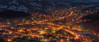
Gorodovikovsk (Republic of Kalmykia)
Gorodovikovsk:| Yashalta | 38 (133) | NE | |
| 2 | Krasnogvardeyskoe (Stavropol Territory) | 41 (91) | SW |
| 3 | Safe (Stavropol Territory) | 48 (83) | IN |
| 4 | Razvilnoe (Rostov region) | 51 (99) | Z |
| 5 | Salsk | 54 (64) | NW |
| 6 | Ladovskaya Balka (Stavropol Territory) | 64 () | SW |
| 7 | Giant (Rostov region) | 65 () | NW |
| 8 | Peschanokopskoe (Rostov region) | 66 (116) | Z |
| 9 | Trunovskoye (Stavropol Territory) | 68 () | YU |
| 10 | Donskoye (Stavropol Territory) | 70 (108) | YU |
| 11 | Proletarsk | 70 (98) | WITH |
| 12 | Abundant | 81 (131) | YU |
| 13 | White Clay (Krasnodar region) | 82 (151) | IN |
| 14 | Novotroitskaya (Stavropol Territory) | 83 () | YU |
| 15 | Novoaleksandrovsk | 84 (139) | SW |
| 16 | Ipatovo | 85 (103) | SE |
| 17 | Tselina (Rostov region) | 85 (109) | NW |
| 18 | Kugulta (Stavropol Territory) | 87 () | SE |
| 19 | Orlovsky (Rostov region) | 87 (130) | WITH |
| 20 | Moskovskoye (Stavropol Territory) | 88 (122) | YU |
| 21 | Rashevatskaya (Stavropol Territory) | 89 () | SW |
| 22 | Blagodatnoe (Stavropol Territory) | 91 () | SE |
| 23 | Ryzdvyany (Stavropol Territory) | 91 (149) | YU |
| 24 | Solnechnodolsk (Stavropol Territory) | 93 (155) | YU |
| 25 | Novopokrovskaya (Krasnodar region) | 96 (171) | Z |
| 26 | Pelagiada (Stavropol Territory) | 98 () | YU |
| 27 | Konstantinovskoe (Stavropol Territory) | 102 () | SE |
| 28 | Grachevka (Stavropol Territory) | 104 (197) | YU |
| 29 | Mikhailovsk | 105 (173) | YU |
| 30 | Svetlograd | 109 (159) | SE |
a brief description of
Located on the Kuma-Manych depression, on the river. Bashantenon, 60 km from the railway. Salsk station, 240 km west of Elista
Territory (sq. km): 152
Historical sketch
Founded in 1872 as the Kalmyk settlement of Bashanta (Mongolian baishin “house”).
Since 1909, the administrative center of the Bolshederbetovsky (from 1930 Western) ulus. Since 1938, the working village of Bashanta.
The city of Gorodovikovsk has been named after the Soviet military leader Hero of the Soviet Union O.I. since 1971. Gorodovikov (1879-1960).
Some numbers
| Index | 2001 |
| Demography | |
| Number of births, per 1000 population | 12 |
| Number of deaths, per 1000 population | 16.2 |
| Natural increase (decrease), per 1000 population | -4.2 |
| Standard of living of the population and social sphere | |
| Average monthly nominal accrued wages, rub. | 1407 |
| Average housing area per inhabitant (at the end of the year), sq.m. | 19.5 |
| Number of preschool institutions, pcs. | 5 |
| Number of children in preschool institutions, thousand people | 0.3 |
| Number of daytime educational institutions (at the beginning of the school year), pcs. | 5 |
| Number of students in daytime educational institutions, thousand people | 1.9 |
| Number of doctors, people. | 35 |
| Number of nursing staff, people. | 105 |
| Number of hospital institutions, pcs. | 1 |
| Number of hospital beds, thousand units | 0.1 |
| Number of medical outpatient clinics, pcs. | 1 |
| Capacity of medical outpatient clinics, visits per shift, thousand units. | 0.2 |
| Number of registered crimes, pcs. | 230 |
| Persons who committed crimes were identified, persons. | 277 |
| Economy, industry | |
| Number of enterprises and organizations (at the end of the year), pcs. | 350 |
| Construction | |
| Volume of work performed by type of activity “Construction” (before 2004 - volume of work performed under construction contracts), million rubles. | 101.9 |
| Commissioning of residential buildings, thousand sq.m. of total area | 2.9 |
| Commissioning of residential buildings, apartments | 38 |
| Transport | |
| Number of bus routes (in intracity traffic), pcs. | 1 |
| Number of passengers transported by buses per year (in intracity traffic), million people. | 7.7 |
| Connection | |
| Number of residential telephone sets of the city public telephone network, thousand units. | 1.7 |
| Trade and services to the population | |
| Retail trade turnover (in actual prices), million rubles. | 2.1 |
| Retail trade turnover (in actual prices), per capita, rub. | 206 |
| Public catering turnover (in actual prices), million rubles. | 178 |
| Volume of paid services to the population (in actual prices), million rubles. | 16.6 |
| Volume of paid services to the population (in actual prices), per capita, rub. | 1627 |
| Volume of household services to the population (in actual prices), million rubles. | 0.2 |
| Volume of household services to the population (in actual prices), per capita, rub. | 20 |
| Investments | |
| Investments in fixed assets (in actual prices), million rubles. | 7.4 |
| Share of investments in fixed assets financed from budgetary funds in the total volume of investments, % | 28.4 |
Data sources:
Regions of Russia. Main characteristics of the constituent entities of the Russian Federation: statistical collection. Goskomstat of Russia. – M:, 2003.
Economy
Brick, canning, butter factories. Meat processing plant, folk crafts plant, etc.
In the Gorodovikovsky district, wheat, barley, buckwheat, sunflower, corn, vegetables, and melons are grown. They raise cattle, pigs, sheep, goats, and horses.
Deposits of natural gas, brick clay, gypsum, fresh water.
Main enterprises
PLANT CULTIVATION
Agricultural production cooperative “New Life”
359000, Republic of Kalmykia, Gorodovikovsky district, Gorodovikovsk,
Offers:
Crop production
Museums, galleries, exhibition halls
Gorodovikovsky Museum of Local Lore 359050, Republic of Kalmykia, Gorodovikovsky district, Gorodovikovsk, st. Lenina, 13 Phone(s): (231) 9-1909
Architecture, sights
The water tower (1909, height 38 m) has been preserved.
Natural monument – Bashanta oak grove (the first trees were planted in 1887).
2 things to do in Gorodovikovsk:
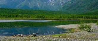
- Go fishing - the bite is great here. In Kalmykia, fishing is generally okay. Over the weekend you can catch tens of kilos of small pike, perch and carp. It’s worth finding out in advance which places you can fish in and where it’s better not to go. The fact is that local residents are jealous of visiting fishermen. So, to avoid conflict, it is better to collect information.
- Hunt - in Kalmykia, hunting is one of the main ways of obtaining meat, and for tourists it is one of the entertainments. Here they hunt hare, fox, wild boar, and various birds.
Commercial bases offer their services tastefully. However, you need to be careful: entrepreneurs are ready to use various tricks just to lure a client. For example, they post unverified information on the site or post old photographs without talking about what is happening now in the “fat” places. So when choosing a database, you should trust trusted sources and authoritative sites.