General information about the Sakhalin region
Distinctive features .
The only region in Russia entirely located on islands is the Sakhalin region. It includes the island of Sakhalin and the Kuril Islands. Perhaps this is, if not the most distant, then certainly the most inaccessible region of the Russian Federation. We learned about Sakhalin thanks to Russian pioneers who explored the shores of the Pacific Ocean in the 17th century. The Kuril Islands were discovered a little later - in 1711. Until the 19th century, no one laid claim to either the Kuril Islands or Sakhalin. The Ainu and Nivkhs lived there, who did not bother anyone, and were engaged in fishing and gathering. But over time, a struggle began between Russia and Japan for these islands, and questions about the ownership of the Kuril Islands are still periodically raised by the Japanese, who consider the four Kuril Islands to be their “northern territories.” What is the background to the conflict?
After the signing of the first border treaty between Russia and Japan in 1855, the island became the joint possession of the two states. In 1875, the countries “gave up”, and the southern part of Sakhalin passed to Russia, and Japan received all the Kuril Islands. In 1905, after Russia's defeat in the Russo-Japanese War, the southern part of Sakhalin officially passed to Japan. After the victory over Japan in 1945, the Soviet Union regained both Sakhalin and the Kuril Islands. Today Russia denies any possibility of changing the status of the Kuril Islands.
Geographical location . The Sakhalin region is located in the Far East and includes the islands of the Sea of Okhotsk - Sakhalin and the Kuril Islands archipelago. Therefore, it does not border any regions by land. By sea, its borders pass with the Kamchatka Territory in the north, the Khabarovsk Territory in the west, and with Japan in the south. The Sakhalin region is part of the Far Eastern Federal District.
Due to its large extent from north to south, the nature of the Sakhalin region is very diverse. If in the north of the Kuril Islands mostly shrubs grow, reminding us of the northern tundra, then in the south coniferous forests are already stretching with might and main, and the southern part of Sakhalin Island is also rich in deciduous forests. There are very few rivers; Sakhalin has several large rivers (Tum, Poronai, Lyutoga, Naiba).
Volcanoes of the Kuril Islands similar to giant waste heaps
Life on the islands has its own specifics. All of them are located in a seismically active zone. Therefore, there are many dangers for local residents. These include earthquakes and active volcanoes in the Kuril Islands. This includes tsunamis that can destroy entire cities. So, in 1952, a giant wave completely washed away Severo-Kurilsk, on the island of Paramushir. However, the city was rebuilt and people still live there.
Population. Although the Sakhalin region is located, from the point of view of a resident of the capital, almost at the end of the world, it is not such a sparsely populated region. In total, 493,302 people live here. Although in its best times, in 1990-1991, as many as 715 thousand people lived here.
80% of the population lives in cities. By national composition, 82% are Russians, 5% are Koreans, 2.44% are Ukrainians. Nivkhs make up only 0.44% of the region's population. The ratio of male to female population is 48% to 52%.
Residents of Yuzhno-Sakhalinsk have been accustomed to winter sports since childhood.
Crime . 29th place in the ranking of regions by the number of crimes committed. And this is not surprising. Harsh climate, drunkenness, corruption, unemployment - all this contributes to the development of crime.
The unemployment rate in Sakhalin is quite high - 7.66%. This corresponds to 60th place in the regional ranking. Needless to say, there are few businesses here. But in terms of domestic regional product per capita, the Sakhalin region is in third place.
Above are only Moscow (it’s clear why) and the Tyumen region (it’s also clear why - oil). The reasons for such success of the Sakhalin region are the oil, gas and gas condensate deposits found here. In terms of the volume of explored reserves of the latter, the Sakhalin region ranks 4th in the Russian Federation. On the Kuril Islands everything is much worse. In the southern Kuril Islands, people are mainly engaged in fish processing. Perhaps the joint exploitation of the southern islands with Japan, proposed by the Russian government, will somehow change the situation in the region.
The first gas power unit of the Yuzhno-Sakhalinskaya CHPP
The average monthly salary in the Sakhalin region is 39 thousand rubles. And the highest salaries are in the public administration sector (57 thousand rubles), financial activities (76 thousand rubles) and the extraction of fuel and energy minerals (64 thousand rubles). But this is not the case everywhere. For example, in various manufacturing industries the average salary is 13-14 thousand rubles.
Real estate value . Prices for apartments in the regional capital Yuzhno-Sakhalinsk are quite high: on average, a square meter here costs more than 70 thousand rubles. One-room apartments cost 2.7-3 million rubles. And these figures will only grow. But since salaries on Sakhalin are also decent, such housing is quite affordable for locals.
The climate of the Sakhalin region is influenced by the Sea of Okhotsk and the Kuril Current and is characterized by cold summers and severe frosty winters. The average temperature in February is −8°C, in August - from +10 to +17°C, depending on latitude. In summer there are frequent fogs, typhoons, and monsoon rains. The annual precipitation is 700-1000 mm.
How to get to Sakhalin
Sakhalin on the map of Russia gives an idea of the distance to it. The fastest way to get there is by plane. There are 2 options: fly to Yuzhno-Sakhalinsk or Vladivostok.
The most convenient way to get to the island is a non-stop flight from Moscow to Yuzhno-Sakhalinsk airport. The flight takes about 8.5 hours. Modern airliners are equipped with individual audio and video systems, and flight information is available to each passenger. Travelers are provided with hot meals, which are served twice. The time difference with Moscow is 8 hours.
If you were unable to purchase a ticket for a direct flight, you can fly to the international airport in Vladivostok, then by plane 2 hours to Yuzhno-Sakhalinsk.
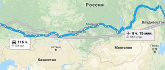
Those wishing to see the country “from edge to edge” can be offered a train trip on the route Moscow – Vladivostok. There are 2 options: and the luxury tourist class “Imperial Russia”. The duration of the trip is at least 7 days. Then from Vladivostok in 2 hours by plane to Yuzhno-Sakhalinsk.
A more difficult option to get to Sakhalin is by ferry. The ferry service connects the mainland port of Vanino and the island port of Kholmsk. A regular bus runs between Kholmsk and Yuzhno-Sakhalinsk. You can get to Vanino by personal transport, but the road is of poor quality.
You can get to Vanino by train from Khabarovsk - 1 day, from Vladivostok - 2 days. The ferry journey takes about 12 hours. If desired, personal transport can be loaded onto the ferry by pre-booking a seat for it. There is a gas station in Kholmsk, the A-392 highway will lead to Yuzhno-Sakhalinsk in an hour.
Thermal springs
There are many thermal springs on Sakhalin, since the island is located in an area of active volcanoes. However, only 2 groups out of all are used.
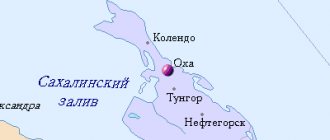
- Daginsky springs located within the lagoon north of the village of Nogliki. During the Soviet era, a hospital was located here. Now only the Patriot spring has the appropriate design; the rest are hot puddles and pits with water. In summer, those wishing to take water or mud baths are accommodated in tents near the springs.
Supporters of organized treatment can purchase a ticket to the Dagi-Oasis sanatorium complex in the small village of Goryachiye Klyuchi. Those who are accustomed to life in hotels will be satisfied with a hotel room in the village of Nogliki. People get here by train from Yuzhno-Sakhalinsk, then by car along an asphalt road.
- Not far from Yuzhno-Sakhalinsk there are Sinegorsk springs. Their composition is unique because they contain arsenic. The sanatorium has a staff of highly qualified specialists to provide assistance to vacationers. The sanatorium is located in the village of Sanatornoye, which is easily accessible by bus or car from Yuzhno-Sakhalinsk.
Features of the flora and fauna of Sakhalin
Due to the peculiarities of the Sakhalin climate, the flora of the island requires separate consideration for each climatic region.
For the northern part, where plains and many wetlands predominate, mosses and lichens are ubiquitous. In rare meadows there are forbs and sedges. Taiga massifs consist mainly of larches and cedars. To the south, spruce and fir trees appear; dwarf cedar dominates the mountain slopes.
The most interesting is the flora of southern Sakhalin. Northern taiga and southern species coexist here. Spruce and larches are entwined with vines of wild grapes and lemongrass. Hydrangea and rhododendron shrubs among yews and yellow maples.
The dwarf cedar grows next to the cork tree, mountain sakura and weigela. The hollies are surrounded by ferns. In the undergrowth there are often impenetrable thickets of Kuril bamboo. In the river valleys, willows and alders common to the middle zone are common, and oaks and ash trees are also found. The fauna of Sakhalin is not rich.
These are mainly taiga representatives:
- Brown bear;
- wolverine;
- fox;
- white hare;
- squirrel;
- chipmunk;
- ermine;
- weasel.
There are still wild reindeer in the north. There are many birds on Sakhalin; some stop here to rest on their way if they fly from afar. Indigenous species are common to the taiga and forests of Russia. On some secluded lakes, white swans breed their chicks in the summer. In the forests of southern Sakhalin there are birds and butterflies characteristic of the more southern region - the island of Hokkaido.
The world's largest fur seal rookery is registered on Tyuleniy Island.
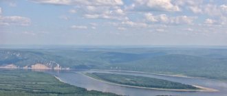
Inland waters
Sakhalin on the map of Russia is a region with a dense river network. However, most rivers are small rivers, mostly mountainous. There are only two rivers on the island more than 300 km long, and several more 120-130 km long.
There are more than 16 thousand lakes on the island.
The largest ones are of the lagoon type. Small lakes are represented by oxbow lakes, thermokarst and dammed lakes in mountainous areas.
Neva Lake on Sakhalin
| Rivers | Lakes |
| Poronai | Nevskoe |
| Tym | Tunaicha |
| Lutoga | Besse |
| Langeri | Ayinskoe |
| Rukutama |
Of these, the first 4 rivers flow into various bays of the Sea of Okhotsk, the last one into Lake Nevskoye.
Ski resorts
In winter, the capital of the island offers the following options for vacationers:
- The Mountain Air complex is located within the city of Yuzhno-Sakhalinsk. Comfortable accommodation, stable snow cover on several slopes, modern ski lifts, equipment rental.
- Winter resorts Tomari less known, but gradually developing. The trip to Tomari will take 4.5 hours by commuter train.
It is important for tourists to decide on travel dates in advance. Although Sakhalin does not look very expressive on the map of winter tourism in Russia, the winter months from the first days of December to the last days of April are suitable for skiers to relax. Sanatoriums operate regardless of the time of year. It is better to postpone sightseeing until the summer.
Article design: Mila Friedan
Minerals
The island's mineral resources are very diverse. The main one is oil and gas deposits. Thanks to this, Sakhalin hosts a unique gas liquefaction facility, which, along with oil, is successfully exported.
High quality hard coal is actively mined and used locally. Deposits of gold and germanium are important. Currently, a rich deposit of chromite ores has been discovered. Large-scale construction is underway on Sakhalin, so the extraction of limestone for cement production is also a priority.
In addition, there are many small ore occurrences of non-ferrous metals, but they have not yet been developed. The region is characterized by valuable mineralized and hot underground waters, since the island is located in the Pacific “Ring of Fire” zone.