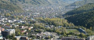
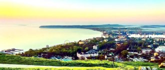
Gorno-Altaisk is the capital and the only settlement with city status in the Altai Republic, located in Western Siberia. The city's population is approximately 63 thousand inhabitants.
Previously, until the 20s of the 19th century, on the site of Gorno-Altaisk there were settlements of Turkic nomadic Teleut tribes. In 1924, the first Russians arrived here from the city of Biysk, who named their settlement Ulala. Here the priests of the Russian Orthodox Church were engaged in missionary work, striving to convert most of the infidels and pagans living in Altai to the Christian faith.
Businessmen from Biysk flocked to the village, and by the end of the 19th century it was turning into a major economic center of Siberia.
On February 27, 1928, the village was recognized as a city. In 1932, the old name was changed to Oirot-Turu, and then, in 1948, it was changed to Gorno-Altaisk.
Currently, the city exists thanks to the developed tourism industry. The plans of local authorities include the implementation of a large-scale construction project of a ski complex with hotels, a cable car and other elements of developed infrastructure.
Description and history of the development of Gorno-Altaisk
Gorno-Altaisk is located in Russia, in the south of Western Siberia. The city is the capital of the Altai Republic. The area of Gorno-Altaisk almost reaches 100 square kilometers, and the number of local residents exceeds sixty-three thousand people. The city stands at the confluence of the Ulalushka and Maima rivers, not far from the Altai Mountains. Local time differs from Moscow by +4 hours.
Altai is translated from the Turkic and Mongolian languages as “gold”, that is, Gorno-Altaisk - “mountain gold”
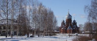
Gorno-Altaisk is a fairly young city. The first mention of settlements in this place dates back to the beginning of the 19th century - then Teleuts lived in this area. A little later, Russian residents also appeared here and formed the village of Ulala. Also, clergy and merchants settled in the village, thanks to which Ulala began to develop in the commercial sphere. By the end of the 19th century, the village was one of the largest shopping centers in the Tomsk province, which it was part of at that time. After the Revolution of 1917, the village became the center of the newly formed Oirot Autonomous Region, and in 1928 Ulala received city status. Four years later, the settlement was renamed Oirot-Turu, and in 1948 - Gorno-Altaisk. Having received a new name, the city entered a new period: they began to build residential buildings and erect factories. In 1992, Gorno-Altaisk became the capital of the Altai Republic.
Natural attractions
Chuysky tract
The Chuysky tract is one of the most famous and ancient roads not only in Altai, but throughout Russia. This is one of the 10 most beautiful roads in the world according to National Geographic. The first mentions of this road were found in Chinese chronicles dating back to the last millennium. At that time, the Mungal tract was still used by traders and warriors traveling from Russia to Mongolia and China. The modern Chuisky tract is a paved road that leads from Novosibirsk through Altai to Mongolia, and then through China to the Arabian Sea in the Pakistani port of Karachi.
In addition, the Chuysky tract is the main road that tourists use to travel around Altai. Not far from it are the tourist centers of Chemal and Turyuzovaya Katun, the famous Katu-Yaryk pass and the valley of the Chulyshman River. The tract passes both through the Southern and near the North Chuysky ridge. Well, driving along the historical part of the tract from Biysk to the border with Mongolia, you can see Mongolian burial mounds and stone women (images) guarding them.
"Altai Mars"
Do you want to go on vacation in Altai and suddenly find yourself on another planet? Let's say on Mars? Then you definitely need to go to the valley of the Kyzyl-Chin River, which is located 7.5 km from the Chuysky tract in the Altai Republic. Due to the fact that the local soil is full of polymetallic ores, the color of the mountains here acquires multi-colored shades. Mostly red. In addition, there is almost no vegetation on such soil. All this makes the valley of the Kyzyl-Chin River a real Mars.
The Martian Valley in Altai, although a famous place, is not as popular as the Katu-Yaryk pass. Therefore, there will not be huge crowds of tourists here, which means you can walk around the local Mars in relative solitude and feel like a real explorer of another planet. And, of course, the photographs from these places are simply exceptional. So if you've ever dreamed of becoming an astronaut, it's time to make that dream come true in Altai.
Geyser Lake
Small (only 30 meters in diameter), but colorful Geyser Lake is located in the Altai Republic, 165 km from the border of Russia and Mongolia. The lake in Altai surprisingly resembles the American lake in Yellowstone Park. In its middle, geysers also come out, and with them blue silt rises to the surface from the bottom. Thanks to this, the water in the Altai lake acquires an unusual blue hue. From the center of the lake, this silt spreads out into concentric rings and gradually changes its color.
Katun River
Katun is the main river in Altai, even its name is translated from Altai as “mistress”. The source of the river is located on the slope of the highest mountain in the region - Belukha. Then Katun spills throughout the region, passing through the territory of the Altai Territory and the Altai Republic. The most popular place to relax on the river is the special tourist zone “Turquoise Katun”. There are hotels, cafes and shops here, and excursions and expeditions around Altai depart from here.
In addition to the tourist and entertainment infrastructure, in the vicinity of Turquoise Katun there are several interesting places where it is worth going on an excursion:
- Tavdinsky caves with a length of 5 km, located on the left bank of the river;
- Tavdinskaya arch is a karst arch (width - 13 meters, height - 5 meters) in the mountains above Katun;
- Maralniks are special farms in Altai where rare maral deer are bred. These deer are known for their antlers, or rather antlers, which are widely used in medicine and cosmetology.
Mount Belukha
Mount Belukha is the main one among all the natural attractions of the Altai Mountains. This is the highest peak in Altai - 4509 meters above sea level. It is located on the Katunsky ridge. The border between Russia and Kazakhstan runs along this mountain range. The mountain itself belongs to the Altai Republic and is part of the Katunsky Nature Reserve. In addition, it is included in the UNESCO World Heritage List as part of the Golden Mountains of Altai complex.
Belukha got its name because of the abundance of snow, which covers it almost to the very foot. Locals call the mountain differently. In Kazakh, her name sounds like “Kadyn-Bazhy”, which means “Top of the Katun”. In the South Altai language (one of the main languages in the Altai Mountains), Belukha is known as “Uch-Sumer”, or “three-headed”. You can’t argue with either one. One of the most famous rivers in Altai, the Katun, originates from the slopes of Belukha. Well, the mountain itself actually has several peaks.
Katu-Yaryk pass and Chulyshman river valley
The valley of the Chulyshman River is one of the pearls of the Altai Mountains. There are three main reasons why tourists are so attracted to this area:
- from the top of an almost 900-meter mountain there is a breathtaking view of the valley of the Chulyshman River;
- the descent into the valley, where all tourists rush, takes place along an amazing, although quite dangerous, mountain serpentine (3.9 km long) at the Katu-Yaryk pass;
- The tourist infrastructure is quite developed here, there are cafes, equipped toilets and a parking lot.
However, remember that the Katu-Yaryk pass is not only quite dangerous for inexperienced drivers, but also treacherous even with professionals. Almost any car can go down to the valley of the Chulyshman River along a steep mountain serpentine road, but many people cannot go back up. It is best to use SUVs that are not too overloaded on the pass.
"Stone Mushrooms"
Ak-Kurum stone mushrooms are high rocks that stand alone on the slopes of mountain ranges in the valley of the Karasuk River. Ak-Kurum means “white scree”. In Altai, scree (kurum) is precisely the name given to huge boulders resulting from the weathering of rock. So stone mushrooms in Altai appeared in the process of soil erosion - wind and precipitation gradually carried away pieces of rocks.
Why do we call these rocks stone mushrooms in Russian? The fact is that on the tops of these weathered rocks there are massive boulders that from a distance resemble mushroom caps. True, if you want to see this miracle of nature, then you should hurry. The Ak-Kurum stone mushrooms continue to collapse. In addition, periodic earthquakes in Altai negatively affect this natural attraction.
Lake Teletskoye
Lake Teletskoye is the largest in Altai. Its area is 223 km², and its depth reaches 325 meters. The lake contains a large supply of clean fresh water, and its transparency reaches 14 meters in depth. That is why Lake Teletskoye is often called small Baikal. However, like Baikal, it is recognized as a UNESCO World Heritage Site as part of the Golden Mountains of Altai complex.
The Teletskoye Lake area is extremely popular among tourists. There is all the necessary infrastructure for recreation, and in the surrounding area you can walk along mountain trails and see several other natural attractions:
- Korbu waterfall is one of the most famous in the Altai Mountains. Its height is 12 meters, and at the mouth of Korbu is the deepest place of the lake. The only way to get to the observation deck at the waterfall is to come here by boat.
- Stone Bay is located 4 km from the village of Artybash - the main tourist center on Lake Teletskoye. According to legend, a meteorite fell into this place, and that is why the coast of the bay is strewn with huge boulders, some of them taller than a man.
- Kishte waterfall translated from Altai means “calling”. It is significantly smaller in size than Korb. However, here a much larger volume of water falls at an incredible speed. That is why Kishte is considered the loudest waterfall in Altai.
- Yailyu pine grows almost at the very edge of the water on Lake Teletskoye. The tree is called “bowed”, or drunk. Even in the last century, a pine tree in the village of Yaylyu tilted strongly towards the ground. Tides and storms on the lake have washed away all the soil from its roots, but the tree continues to cling to the ground and grow even in this state.
Ukok Plateau
The Ukok plateau (or plateau) is located in the Kosh-Agach region of Altai and is considered one of the most mysterious places on the map of Russia. The location of the plateau is such that it is equidistant from the four oceans; In addition, Ukok is located on the border of four countries: Russia, Kazakhstan, China and Mongolia. Its average height ranges from two to two and a half thousand meters above sea level.
From the Mongolian language “Ukok” is translated as “cabinet”, “elongated box” or “massive mountain”. The plateau is known not only for its amazing landscapes and harsh climate, but also for its archaeological finds. For example, it was here that the ancient burial of a girl was discovered - the famous “Altai Princess”.
Multinskie lakes
Multinskie lakes are a whole cascade of lakes in the upper reaches of the Multa River. There are three lakes in total: Lower, Middle, Upper. Nearby there are also lakes Poperechnoye, Verkhneye transverse, Kuiguk and Krepkoye. The Multinskie lakes are located quite far from populated areas, and a trip to them will turn out to be a real hiking trip. People usually get here on foot or in off-road vehicles.
In summer, the water heats up to fifteen degrees, and it is quite possible to swim in the lakes. But first of all, people come to this area for the scenery and walks in the surrounding area. Coniferous forests, boulders covered with cedars, mountain slopes, clearings and picturesque trails equipped for tourists, mirror-like surface of water and the sound of waterfalls - all this awaits travelers who go to Multinskie Lakes.
Shavlinskie lakes
The chain of Shavlinsky lakes stretches along the North Chuysky ridge for almost ten kilometers. These lakes are famous throughout the world - not only for their beauty, but also for the amazingly rich color of the water: blue, green, azure... The reservoirs border mountain slopes and flowering meadows, and in the Upper Shavlinskoye Lake three peaks are reflected at once - Beauty, Dream and Fairy Tale.
Shavlinsky lakes are cold, the weather here is changeable, but some travelers still dare to swim, especially on sunny days. On rainy days, the clouds descend along the mountain slopes to the water itself and, reflected in the surface of the lake, paint it in deep, dark tones.
Karakol Valley
The valley along the Karakol River is one of the most sacred places in Altai. This small area (the length of the valley is only 3 km) contains the largest number of burial mounds, ancient sacrificial altars and stone slabs, as well as rock paintings. Moreover, it was here that for the first time in Altai, multi-colored petroglyphs were found, made using mineral paints of white, black and red.
In order to preserve the historical and cultural monuments found in this area, in 2001 the territory of the Karakol Valley and its surroundings was united into the Uch-Enmek Natural Park with a total area of 60.5 thousand hectares. Are you looking for where to go in Altai to find a mysterious place imbued with ancient history? The Karakol Valley is what you need.
Aktru Glaciers
The seven Aktru glaciers occupy about sixteen square kilometers, and their slopes have an interesting feature: the northern sides are much steeper than the southern ones.
Among the glaciers there are valley, flat-topped, corrugated and even a hanging glacier called “Tronov's Pants”, as well as a hanging glacier called “Trainee” or “Container”. The Aktru mountain-glacial basin is located on the North Chuisky ridge. Most of the glaciers are suitable for mountaineering, but the routes require special preparation. However, there are places where you can walk even without mountaineering experience. Blue Lake, the icy Aktru River with its waterfall, and the Ram’s Foreheads chain of hills are a few more attractions of this area.
Uchar Waterfall
Uchar Waterfall is the second name of the Big Chulchinsky Waterfall, located on the territory of the Altai State Nature Reserve. According to different versions, “Uchar” means “flying” or “impregnable”. Both are true: this is the highest cascading waterfall in Altai with a total fall height of one hundred and sixty meters. It even made it onto the list of the five most inaccessible attractions in our country.
Uchar is located in the Ak Cholushpa natural park. Sometimes this waterfall is called a waterfall because the water in it flows down a steep slope rather than falling. But this does not make it any less impressive: the frantic speed of the flow creates such noise that it is impossible to talk near the “Flying”.
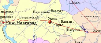
Table: how to get to the city of Gorno-Altaisk
| Point of departure | Airplane | Bus | Automobile |
| Moscow | On Thursdays and Sundays there are flights from Domodedovo Airport twice a day. Travel time: 4 hours 20 minutes. Flight cost: from 11,800 rubles. | There are no direct flights. | Route length: 3785 kilometers. Approximate travel time: 2–3 days. Routes: M7, M5, P254, P256. |
| Krasnoyarsk | Flights operate daily, except Tuesday and Thursday, from Yemelyanovo airport. Flight time: 2.5 hours. Flight cost: from 3900 rubles. | There are no direct flights. | Distance between cities: 1093 kilometers. Travel time: 10–11 hours. Routes: P255, P256. |
| Novosibirsk | Flights operate daily, except Tuesday and Thursday, from Tolmachevo Airport. Flight time: 1.5 hours. Ticket price: from 3200 rubles. | There are four daily flights. Travel time: 7.5–8.5 hours. Cost of the trip: from 1300 rubles. | Distance between cities: 450 kilometers. Travel time: 4.5–5.5 hours. Route: P256. |
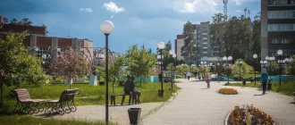
Spring on Kommunistichesky Avenue
Kommunistichesky Avenue is the central street of the capital city of Gorno-Altaisk. Here a powerful spring gushes out of the ground. A natural source of clean and tasty water is located near the Dynamo stadium. The territory of the spring is decorated with sculptural compositions. The sculpture “Yrystu and Alyonushka” is installed here, which depicts Yrystu, the hero of the Altai folk epic, and Alyonushka, the heroine of a Russian fairy tale. The sculptural group stands on a stone pedestal installed next to the spring of the same name. Marble statues of fairy-tale heroes are a symbol of friendship between the Russian and Altai people. They were created by local sculptor P.I. Bogomolov.
Where to go for tourists with children
There are not many places for children's leisure in Gorno-Altaisk. The most popular are:
- Park of culture and recreation. During the summer, the park offers various attractions that will be most interesting for young children. Address: Sportivny Avenue, building 3.
- Gamer slot machine hall. In a small area of the hall there are about twenty slot machines aimed at adults and children of various ages. Address: Kommunistichesky Avenue, building 11, shopping center "Maria-Ra", 3rd floor. Opening hours: from 10 am to 10 pm.
The slot machine hall is a great opportunity to have fun - Children's playroom "Rainbow". The play area includes several fun rides, children's slides, mazes, ball pits and many other entertaining games. Address: Kommunistichesky Avenue, building 109/2, Gorny shopping center, 1st floor. Opening hours: from 10 am to 8 pm.
In the playroom you can leave your child under the supervision of employees - The Good Troll board game club is an entertainment area not only for children, but also for adults. Here are hundreds of the most exciting board games that you can play with your group or with complete strangers. There is a special children's series of games for children. Address: Kommunistichesky Avenue, building 39. Opening hours: from 11 am to 8 pm.
Board games are a fun pastime for children over 7 years old
City panoramic park "Mount Tugaya"
The mountain is located in the central part of Gorno-Altaisk. Its name comes from the Altai word “Tuu-Kaya”, which means “rock mountain”. The toponym is also associated with the word “Uyt-Kaya”, “kaya” is a rock, uyt is a depression, in Russian the phrase “rock with depressions” is obtained. The height of the mountain peaks reaches more than 641 m. In the winter season, you can come here for active skiing. And in the spring, traditional rituals associated with the national holiday “Chaga Bayram” are organized here. The panoramic park named “Mount Tuugaya”, founded in 2022, is also located on this territory. The infrastructure of the park complex includes observation platforms, a platform for rituals “Altai Spring” and a 750-step stone staircase.
Tips for staying in Gorno-Altaisk
Gorno-Altaisk is located between mountains, which greatly influences the climate in the city. The weather can change dramatically several times a day: in the morning - rain, in the afternoon - sun, and in the evening - rain again. Both winter and summer often experience prolonged precipitation. Summers in the city are hot, and winters are cold and long.
The hottest month is July, the temperature stays around 30 degrees. It is in July that the city is visited by the largest number of tourists. June is often marred by rain, but in August the temperature can drop sharply to +15 degrees. Among the summer entertainments, travelers can enjoy rafting along the mountain-glacial rivers of the Altai Republic. As a rule, beginners are offered a one-hour rafting, but there are also more difficult levels: two- and even eight-hour rafting. For big fans of extreme recreation, the city offers multi-day water tours with river rafting and accommodation in a forest in a tent camp.
Rafting tours in Altai are a real active holiday, a sea of emotions, adrenaline and pleasant memories
Throughout the autumn and most of the spring in Gorno-Altaisk it is quite cold and rainy. In winter, the city becomes attractive for ski lovers. There are two resorts in close proximity to the city. There are three trails with a lift on Mount Tugaya, and on Mount Komsomolskaya there is one trail with a red difficulty level for professional athletes. Equipment rentals are available on both slopes. There are also more than five ski resorts operating at various distances from Gorno-Altaisk. In winter, the city celebrates Chaga Bayram - the national New Year of the Altai people. The festivities last for several days in mid-February, during which various competitions are organized, rituals are held, and national costumes are shown.
Alpine skiing is one of the most popular winter sports in Altai
A week is not enough to see all the sights of the Altai Republic; the memorable places of Gorno-Altaisk can be explored in just one day. But, as a rule, visiting the city is accompanied by trips to the natural monuments of the region, so tourists spend quite a long period in Gorno-Altaisk. There are more than fifty hotels in the city, in addition, in the surrounding area there are several tourist centers where you can also stay. Buses are becoming the main means of transportation for tourists in Gorno-Altaisk. They run both within the city itself and between neighboring settlements.
Altai souvenir products are unique and varied:
- As useful souvenirs you can purchase:
- balms from mountain herbs;
- Altai honey;
- Cedar oil;
- herbal tea
- The city also offers a wide variety of handmade souvenirs:
- wood paintings;
- tambourines;
- shamanic drums;
The shaman's tambourine is one of the most exotic souvenirs that can be brought from Gorno-Altaisk - carpets;
- wool pillows.
- In addition, popular souvenirs among tourists are various amulets and amulets, as well as locally produced natural cosmetics.
Historical landmarks
"Altai Princess"
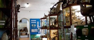
Probably the most unusual exhibit of the National Museum of Gorno-Altaisk is the “Altai Princess,” the mummy of a twenty-five-year-old girl, found in one of the mounds on the Ukok plateau. It is believed that the girl was from a noble family - she was buried according to ancient Altai traditions and was given the responsibility of protecting the world from evil penetrating from otherworldly spheres.
The “Princess” was buried more than two thousand years ago and was found in 1993, but there is still debate about what nationality she belonged to. DNA analysis showed Caucasian roots; anthropologists believe that the facial features of the “princess” are Southern Caucasian, and her clothes are attributed to Turkic or Iranian origin. The Altaians are sure that this girl is the ancestor of their people, Princess Kadyn.
Pazyryk mounds
The Pazyryk mounds are five ancient burial grounds located in the Ulagansky region of Altai. The burials date back to the Iron Age and range from twenty-five to fifty meters in diameter. In the village of Ulagan there is the Pazyryk Museum, the exhibition of which is dedicated to these burials and the entire Pazyryk culture. But the most valuable archaeological finds discovered in the mounds are kept in the Hermitage and in the museums of Novosibirsk and Gorno-Altaisk.
The burial chambers hidden inside the burials are real log houses, inside of which sarcophagi, carts, harnesses and other utensils were placed. Some mounds were plundered in ancient times, but, thanks to the layer of permafrost, many objects from that era were preserved in untouched burials.
Rock paintings on the Kalbak-Tash rock
Petroglyphs, or ancient rock paintings in Altai are found in several places at once. But the largest collection (about 5,000 images) was collected in the Kalbak-Tash tract on the right bank of the Chui River in the area of 723 km of the Chuisky tract. Among the Altai rock paintings there are standard subjects - people and animals, everyday life and hunting, as well as runic writing and solar (solar) signs. These images were created over a long period of time - from the 4th-6th centuries BC until the Middle Ages. The most ancient ones were made with stone tools, later they were replaced by metal ones.
Patmos Island
Patmos Island is a rocky island on the Katun River. The Temple of St. John the Theologian and the Znamensky Convent were built on it. This place is located in the vicinity of the Altai village of Chemal - very popular among tourists for holidays in Altai. The only way to see the church and monastery is to cross the long suspension bridge over the Katun. Its height is 15 meters. It sways violently due to the movement of people and the wind, which terrifies many travelers. But if you are not afraid of heights, then we highly recommend visiting this rocky island and attending a service in the temple.
Denisova Cave
The cave is located on the border of the Altai Territory and the Altai Republic, and it is called that because in the eighteenth century the hermit Dionysius lived in it for many years. Local residents also call the cave differently - Ayu-Tash, which means “Bear Stone”. It is believed that this cave was once home to a powerful Black Shaman who could transform into a bear.
Denisova Cave is a world famous archaeological site. In terms of the significance of archaeological finds, it is compared to the Egyptian pyramids. In 2010, the remains of a man who lived fifty thousand years ago were found in Denisova Cave. Using DNA samples, scientists have determined that this species is different from both Neanderthals and modern humans, and represents a separate branch of evolution, called Denisovan man.
Nicholas Roerich Museum
In the village of Verkh-Uimon of the Altai Republic there is a memorial house-museum of Nicholas Roerich - a monument to Altai history and culture. The museum contains reproductions of many of the artist’s paintings dedicated to the Altai mountains. In addition, on the territory there is a house in which the Roerichs lived during their Central Asian expedition. For Roerich, Altai was interesting as the center of Eurasia, a place of fusion of the cultures of East and West.
Tours of the museum are dedicated to the life and work of the artist, the history of his family and the Central Asian expedition undertaken by the Roerichs. The museum was created at the end of the nineteenth century, later restored by the Siberian Roerich Society, and then opened after reconstruction in 2001.
Vasily Shukshin Museum
Memorial and museum complex created in the writer’s homeland in the village of Srostki, Altai Territory. On the territory of the museum-reserve dedicated to the writer, actor and director Vasily Shukshin, there are three cultural heritage sites: the school where he studied and then worked, the house where he spent his childhood, and the estate bought by Shukshin for his mother. During the excursions you can learn about the fate and work of Vasily Makarovich, about his childhood and school years, about the history of the village of Srostki, where the museum is located.
The museum complex also includes estate lands and memorable corners of the village. The surrounding area also deserves attention: the picturesque Mount Piket, on which stands the monument to Vasily Shukshin, the majestic wide Katun River, Popovsky Island.
On an individual trip to Altai, we will develop a route especially for you and include the most interesting places, select comfortable hotels and organize adventures that will make the trip truly special. Call us on tel. or write to - we'll tell you all the details.
Tract "Yelanda"
The Elanda tract is located on the outskirts of the capital city of Gorno-Altaisk. About 10-11 years ago a recreation area was opened on this territory. The dominant and central object of the complex is an artificial lake. But over time, the reservoir, like the recreation complex itself, lost its former appearance. Now it looks less like a swamp. But swimming is allowed on it. This place is more suitable for relaxing in silence surrounded by nature and fishing.
Mount Komsomolskaya
The mountain range is one of the oldest in Gorno-Altaisk. The peaks of Komsomolskaya Mountain are visible from anywhere in the city. The mountain range was formed more than 700 million years ago. The height of its peaks reaches 421 m. The mountain is famous for its rather rich and rich flora. In the summer season there is peace and quiet here, which is important for a peaceful holiday in the lap of nature. And in winter snowboarders and skiers come here. In addition to paved trails and modern rope tows, there is an artificial snowmaking system.