Demidov
(Smolensk region)
OKATO code:
66211501
Founded:
1499
City since:
1776 City of district subordination (Demidovsky district, Smolensk region)
Center:
Demidovsky district
The city was formerly called:
| Porechye | 1918 |
| Telephone code (reference phone) | |
| 48147***** | 41-20-9 |
Deviation from Moscow time, hours:
0
Geographic latitude:
55°16′
Geographic longitude:
31°31′
Altitude above sea level, meters:
160 Sunrise and sunset times in the city of Demidov
External links [edit]
- Mozhgorod.ru. Entrance to Demidova (in Russian)
| vteAdministrative divisions for the Smolensk region | |||
| Administrative center: Smolensk • Rural area. | |||
| Districts |
| ||
| Cities and towns |
| ||
| Urban settlements |
| ||
Map
| Demidov: maps |
Demidov: photo from space (Google Maps) Demidov: photo from space (Microsoft Virtual Earth)
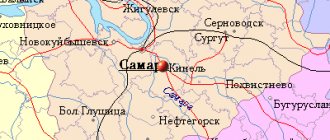
| Demidov. Nearest cities. Distances in km. on the map (in brackets along roads) + direction. Using the hyperlink in the distance , you can get the route (information courtesy of the AutoTransInfo website) | |||
| 1 | Velizh | 42 (46) | NW |
| 2 | Rudnya | 45 (48) | SW |
| 3 | Spirituality | 57 (70) | IN |
| 4 | Smolensk | 63 (92) | SE |
| 5 | Ozerny | 66 (116) | NE |
| 6 | Kardymovo | 71 (111) | SE |
| 7 | Usvyati (Pskov region) | 71 (83) | NW |
| 8 | Yartsevo | 77 (93) | IN |
| 9 | Red | 78 (122) | YU |
| 10 | Zharkovsky (Tver region) | 80 (343) | NE |
| 11 | Monasticism | 104 (148) | YU |
| 12 | White | 109 (165) | NE |
| 13 | Safonovo | 111 (134) | IN |
| 14 | Glinka | 111 (186) | SE |
| 15 | Pochinok | 113 (144) | SE |
| 16 | Western Dvina | 116 (264) | WITH |
| 17 | Kunya (Pskov region) | 118 (189) | WITH |
| 18 | Dorogobuzh | 119 (161) | IN |
| 19 | Verkhnedneprovsky | 120 (154) | IN |
a brief description of
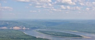
Located between the Vitebsk and Smolensk-Moscow uplands, at the confluence with the river. Kasplya, its right tributary of the river. Gobza (Western Dvina basin), 50 km from the railway. Rudnya station.
There are about 30 lakes in the Demidovsky district (the largest is Akatovskoye). Smolensk Poozerye National Park.
Territory (sq. km): 79
Information about the city of Demidov on the Russian Wikipedia site
Historical sketch
It was first mentioned in 1499 under the name Porechye; the name indicated its location along the river bank. In the 17th century there was a trade border customs office here.
At the beginning of the 18th century. palace village. In 1723, by decree of Peter I, a trading pier was founded here. The road from St. Petersburg to Smolensk and further to Ukraine passed through the village. Small river vessels were built. In the 18th century There was a mint that existed until 1763.
Since 1776, the district town of Porechye of the Smolensk governorship (since 1796 - Smolensk province).
Late 18th - early 19th centuries. - the period of the greatest prosperity of Porechye, mainly as a starting point for ships with hemp, flax, bread and other goods to the Baltic cities. By the middle of the 19th century. the importance of the Porech pier fell due to the shallowing of the river. Kasplya and the construction of a railway to Vitebsk and Minsk away from the city.
During the Patriotic War of 1812 it was burned.
In 1856, in the district town of Porechye, Smolensk province, there were 5 churches, 824 houses, 27 shops.
In 1918, it was renamed Demidov, in honor of the chairman of the district committee of the RCP (b) Ya.E. Demidov (1889-1918).
During the Great Patriotic War of 1941-45, Demidov was occupied by Nazi troops on July 13, 1941. It was liberated on September 22, 1943 by troops of the Kalinin Front during the Dukhovshchina-Demidov operation.
Economy
Factories: flax processing, dairy. Production of underwear knitwear, building materials. Bakery plant, timber industry enterprise.
In the Demidovsky district, rye, oats, barley, flax, potatoes, and vegetables are grown. They raise cattle (meat and dairy), sheep, pigs, and poultry.
Deposits of sand and gravel mixtures, fusible clays, mineral waters and medicinal mud.
Culture, science, education
Museum of History and Local Lore.
Museum N.M. Przhevalsky in the village of Przhevalskoye (formerly Sloboda), where the traveler lived for a long time.
Museums, galleries, exhibition halls
Demidov Museum of History and Local Lore 216240, Smolensk region, Demidov district, Demidov, st.
Kommunisticheskaya, 12 Telephone(s): (48147) 4-1936 Memorial House-Museum N.M. Przhevalsky OGBUK "Smolensk State Museum-Reserve" 216270, Smolensk region, Demidovsky district, town Przhevalskoye, st. Sovetskaya, 49 Phone(s): (48147) 2-63-73 Website: https://www.smolensk-museum.ru/
Museum of Partisan Glory OGBUK "Smolensk State Museum-Reserve" 216270, Smolensk region, Demidovsky district, Przhevalskoye village, st. Sovetskaya, 52 Phone(s): (48147) 2-63-73 2-65-03 Website: https://www.smolensk-museum.ru/
Architecture, sights
The buildings of the old city were located on the right bank of the Kaspli, along which in the 9th-11th centuries. passed the path “from the Varangians to the Greeks”, in the 12-14 centuries. - to the Baltic cities. A center was formed on the arrow at the merger of Kaspli and Gobza. According to the regular plan of 1780, the city took the form of a rectangle stretched along the river. Kasplya and the roads Smolensk - Vitebsk. According to the regular plan of 1817, the city grew to the southwest.
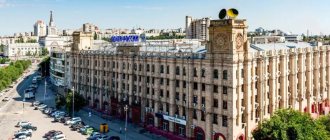
At the end of the 19th - beginning of the 20th centuries. In the center, stone buildings were built in the eclectic and modernist styles - two-story, with dark red brick facing, which largely determine its modern appearance. At the entrance to Demidov from the town of Dukhovshchina at the end of the 19th century. The Spiritual and Annunciation churches were built.
At the end of the Great Patriotic War, the city was restored, maintaining a regular grid of streets. In 1981, a city development project was approved taking into account the preservation of elements of the old city layout.
Architectural monuments of the 18th-19th centuries have been preserved, including the Assumption Cathedral (1851-62), the cemetery Church of the Intercession (1857, chapel - 1865).
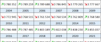
| Population by year (thousands of inhabitants) | |||||||
| 1856 | 3.8 | 1989 | 10.2 | 2006 | 8.3 | 2015 | 6.6 |
| 1897 | 5.7 | 1992 | 9.8 | 2007 | 8.1 | 2016 | 6.5 |
| 1913 | 9.5 | 1996 | 9.9 | 2008 | 8.0 | 2017 | 6.3 |
| 1931 | 5.3 | 1998 | 9.8 | 2010 | 7.8 | 2018 | 6.2 |
| 1939 | 7.9 | 2000 | 9.7 | 2011 | 7.3 | 2019 | 6.1 |
| 1959 | 6.9 | 2001 | 9.6 | 2012 | 7.1 | 2020 | 6.1 |
| 1970 | 8.5 | 2003 | 8.8 | 2013 | 6.9 | 2021 | 6.0 |
| 1979 | 9.7 | 2005 | 8.4 | 2014 | 6.7 | ||
Links[edit]
Notes[edit]
- ^ abcdefghi Resolution No. 261
- ^ a b Federal State Statistics Service (2011). “All-Russian Population Census 2010. Volume 1" [All-Russian Population Census 2010, vol. 1]. All-Russian Population Census 2010 [All-Russian Population Census 2010]
. Federal State Statistics Service. - "26. The size of the permanent population of the Russian Federation by municipalities as of January 1, 2022". Federal State Statistics Service. Retrieved January 23, 2022.
- ^ abcd Law No. 131-z
- Federal State Statistics Service. Federal Agency for Technological Regulation and Metrology. No. OK 033-2013 January 1, 2014 “All-Russian classifier of municipal territories. Code 66 611 101 ". (Federal State Statistics Service. Federal Agency for Technological Regulation and Metrology. No. OK 033-2013 dated January 1, 2014. Russian classification of municipal territories. Code 66 611 101.
). - "On the Calculation of Time". Official Internet portal of legal information
. June 3, 2011. Retrieved January 19, 2022. - Post office. Information and computing center of OASU RPO. ( Post office
).
Search for postal service objects ( postal Search for objects
) (in Russian) - ↑
Federal State Statistics Service of Russia (May 21, 2004).
“The population of Russia, the constituent entities of the Russian Federation as part of federal districts, urban settlements, settlements, settlements of 3 thousand or more people” [Population of Russia, its federal districts, federal districts, districts, urban settlements, rural settlements - administrative centers and rural settlements with a population of more than 3000] (XLS). All-Russian Population Census of 2002 [All-Russian Population Census of 2002]
. - “All-Union Population Census of 1989. The current population of union and autonomous republics, autonomous regions and districts, territories, negative phenomena, urban settlements and rural district centers” [All-Union Population Census of 1989: current population of union and autonomous republics, Autonomous regions and districts , territories, regions, districts, urban settlements, villages performing the functions of district administrative centers. All-Union Population Census of 1989 [All-Union Population Census of 1989]
.
Institute of Demography of the National Research University: Higher School of Economics [Institute of Demography of the National Research University: Higher School of Economics]. 1989 - via Demoscope Weekly
. - ^ a b c Historical information (in Russian). Administration of the Demidovsky district. Retrieved June 16, 2016.
- Egorenkov, L. I. Modern economic and geographical differentiation of the Smolensk region (in Russian) (1). Moscow: Vestnik MGOU: 9–21. Cite journal requires |journal= (help)
- Encyclopedia of the Smolensk region (in Russian). Smolensk Industrial and Economic College. Retrieved June 16, 2016.
- Smolensk province (in Russian). Cartologist - ancient maps of Russia. Retrieved June 18, 2016.
- ^ abc Boris Parfenov; Olga Khorenzhenkova. On the history of the formation of the Smolensk region (in Russian). Smolensk. Retrieved June 18, 2016.
- Industry (in Russian). Administration of the Demidovsky district. Retrieved June 14, 2016.
Sources [edit]
- Administration of the Smolensk region. Resolution No. 261 of April 30, 2008 “On approval of the registration of administrative-territorial units and territorial units of the Smolensk region,” as amended. Resolution No. 464 of June 27, 2014 “On amendments to the register of administrative-territorial units and territorial units of the Smolensk region.” Published: Database “Consultant-plus”. (Administration of the Smolensk region. Resolution No. 261 of April 30, 2008 “ On approval of the Register of administrative-territorial units and territorial units of the Smolensk region”
as amended by Resolution No. 464 of June 27, 2014.
Administrative-territorial units and territorial units of the Smolensk region
). - Smolensk Regional Duma. Law No. 131-z of December 28, 2004 “On granting the status of a municipal district to the municipal formation” Demidovsky district “of the Smolensk region, on establishing the boundaries of municipalities whose territories are part of it, and granting them temporary status,” as amended. Law No. 74-z of May 28, 2015 “On Amendments to the Regional Law” On granting the status of a municipal district to the municipal formation “Demidovsky District” of the Smolensk Region, on approving the boundaries of municipalities whose territories are part of it, and granting them the corresponding status "". Came into force on the date of official publication. Published: “Bulletin of the Smolensk Regional Duma and Administration of the Smolensk Region”, No. 14, part II, p. 6, December 30, 2004 (Smolensk Regional Duma. Law of December 28, 2004 No. 131-z “On assigning the status of a municipal district » municipal formation “Demidovsky district” of the Smolensk region, on establishing the boundaries of municipalities on the territory of which it is located “On assigning them the appropriate status”
as amended by the Law of May 28, 2015 No. 74-z “
On amendments to the regional law "On granting the status of a municipal district to the municipal formation "Demidovsky district" of the Smolensk region", Establishing the boundaries of municipalities whose territories they are included in, and assigning them the appropriate status
. "Valid from the date of official publication.).