Kinel
(Samara Region)
OKATO code:
36408
Founded:
1837
Urban-type settlement since:
1930
City since:
1944 City of regional subordination
Center:
Kinelsky district
Urban-type settlements, population as of 01/1/2021
| Alekseevka | 11.2 | Ust-Kinelsky | 11.3 |
| Telephone code (reference phone) | |
| 84663***** | 21-50-8 |
Deviation from Moscow time, hours:
1
Geographic latitude:
53°14′
Geographic longitude:
50°37′
Altitude above sea level, meters:
35 Sunrise and sunset times in the city of Kinel
What kind of shock village?
Despite his spectacular image, Yuri Petin is not the main shock in the village of Kinel-Cherkassy. The village itself is a shock. The shock is definitely positive. The largest village in Russia “beats” its image of a “record holder from the outback” 100%. There is a fitness center, a television studio, a printing house, a newspaper editorial office, three huge chain supermarkets and... even a travel agency! I can’t even call it a village. “We also have two swimming pools,” says Alexey Zubkov, director of the sports and recreation complex , with a similar shoulder span to actor Porechenkov. “Schoolchildren learn to swim for free, as part of physical education lessons. Then we select the most promising ones and enroll them in professional sections. In the long term - a football field and a hockey rink, running tracks, the area helped to defrost the construction site ... "
Article on the topic
"We think we live in paradise." Why residents of Chekalin do not leave the city
The stores have a wide selection of local products. “This is because we have the most developed private entrepreneurship,” says Vyacheslav Goncharuk, deputy head of the Kinel-Cherkassy district . “You won’t believe it: now there is no free land left for private owners - we are uprooting bushes to meet demand. Our private owners take out the most loans. The district's agricultural department helps them as much as possible - so that people earn money from the land themselves and benefit others. The latest innovation is that we are returning 30% to our greenhouse growers for gas heating of greenhouses. The business incubator is actively working: if someone is thinking about private business, we immediately provide all the necessary legal assistance. We suggest how to receive and use all possible grants, benefits and subsidies for private entrepreneurs (federal, regional and district). And it works! Our Kinel-Cherkassy tomatoes are a brand of regional scale; many villagers at one time “rose” to them. But what is important: when the “tomato attack” came from China, Turkey, etc., people did not fold their hands - they expanded the range, added new crops. And one of the local farmers, in the wake of the demand for original Russian cuisine, is even going to... raise deer! We have very hardworking and enterprising people - this is our main resource.”
The soul of the village is tractor driver and accordion player Vladimir Losev. Photo: AiF / Olga Kostenko-Popova
“In Kinel-Cherkassy there is a cultural event almost every day, three national centers work,” proud Olga Zolotychuk, head of the Department of Culture, Youth Policy and Sports of the Kinel-Cherkassy District . — Last year, the Trinity Day was recreated with rural costumes, chants, and dances from our region. Imagine, it turned out, for example, that a sundress is not “entirely ours,” there were so many discoveries. People do all this with soul and pleasure, not just work from morning to night. We have three theaters: folk, youth and children’s, one premiere after another!” I ask, seeing a picturesque river, right in the middle of the village: “Do you swim in the summer?” I get the answer: “Of course. And last year we had an international beach tennis tournament on the shore, even participants from Brazil came.”
Map
| Kinel: maps |
Kinel: photo from space (Google Maps) Kinel: photo from space (Microsoft Virtual Earth)
| Kinel. Nearest cities. Distances in km. on the map (in brackets along roads) + direction. Using the hyperlink in the distance , you can get the route (information courtesy of the AutoTransInfo website) | |||
| 1 | Ust-Kinelsky | 4 (6) | NW |
| 2 | Alekseevka | 8 (14) | Z |
| 3 | Stroykeramika | 15 () | Z |
| 4 | Smyshlyaevka | 15 (19) | Z |
| 5 | Petra Dubrava | 18 () | NW |
| 6 | Roshchinsky | 21 () | YU |
| 7 | Novosemeykino | 23 (39) | NW |
| 8 | Samara | 33 (36) | Z |
| 9 | Krasny Yar | 33 (46) | NW |
| 10 | Rozhdestveno | 37 () | IN |
| 11 | Krotovka | 37 (45) | IN |
| 12 | Peaceful | 38 (54) | NW |
| 13 | Timashevo | 39 (62) | IN |
| 14 | Volzhsky | 39 (64) | NW |
| 15 | Utevka | 43 () | SE |
| 16 | Novokuibyshevsk | 46 (70) | Z |
| 17 | Kurumoch | 47 (58) | NW |
| 18 | Otradny | 50 (51) | IN |
| 19 | Rich | 51 (60) | SE |
| 20 | Neftegorsk | 60 (99) | SE |
| 21 | Kinel-Cherkasy | 64 (69) | NE |
| 22 | Chapaevsk | 66 (82) | SW |
| 23 | Krasnoarmeyskoe | 69 (96) | SW |
| 24 | Elkhovka | 73 (96) | WITH |
| 25 | Borskoe | 75 (83) | IN |
| 26 | Zhigulevsk | 76 (106) | Z |
| 27 | Bezenchuk | 83 (107) | Z |
| 28 | Alekseevka | 84 () | SE |
| 29 | Sukhodol | 84 (128) | NE |
| 30 | Tolyatti | 85 (102) | Z |
a brief description of
Located on the river. Bolshoy Kinel, near its confluence with Samara, 41 km east of Samara. Railway node
Territory (sq. km): 109
Information about the city of Kinel on the Russian Wikipedia site
Historical sketch
Founded in 1837 as a village. In 1877, during the construction of the Samara-Orenburg railway, a railway was created. Kinel station, a junction since 1888.
Name by location on the river. The Bolshoi Kinel (the right tributary of the Samara), where the Tatar word “wide”, is a truncated form of the Turkic elga “river”, i.e. "wide river". The definition of large contrasts this river with its tributary Maly Kinel.
Workers' village of Kinel from 01/30/1930 City from 03/16/1944
Economy
Kinel is the center of an agricultural region.
A plant for closures, a furniture factory, a clothing factory, and enterprises for servicing railway transport.
In the town of Alekseevka there is a building materials plant and a livestock breeding complex.
Culture, science, education
In the PGT Ust-Kinelsky Samara Agricultural Institute and experimental breeding station.
Museums, galleries, exhibition halls
House-Museum of V.I. Lenin in the village Alakaevka 446404, Samara region, Kinelsky district, village. Alakaevka, st. Leninskaya, 1 Phone(s): (8-84663) 345-74
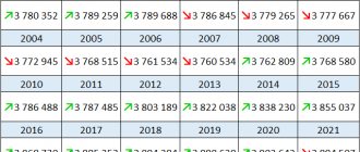
| Population by year (thousands of inhabitants) | |||||||
| 1931 | 6.4 | 1996 | 34.6 | 2008 | 31.5 | 2017 | 35.3 |
| 1939 | 17.0 | 1998 | 34.4 | 2010 | 30.8 | 2018 | 35.7 |
| 1959 | 32.4 | 2000 | 34.5 | 2011 | 34.5 | 2019 | 35.7 |
| 1967 | 36 | 2001 | 34.4 | 2012 | 34.2 | 2020 | 35.8 |
| 1970 | 39.4 | 2003 | 34.4 | 2013 | 34.0 | 2021 | 35.6 |
| 1979 | 42.1 | 2005 | 32.8 | 2014 | 34.3 | ||
| 1989 | 33.4 | 2006 | 32.4 | 2015 | 34.7 | ||
| 1992 | 33.9 | 2007 | 32.0 | 2016 | 34.9 | ||
About the city
The city of Kinel, Samara region (before January 25, 1991, Kuibyshev region) is located 40 km from the regional center. The year of birth of the city is considered to be 1837.
Kinel is located on the left bank of the Bolshoi Kinel River, at the confluence of the Bolshaya Kinel and Samara rivers. Until the 20s of the 19th century, the richest land in this basin was empty.
Once upon a time, in the early 30s of the 19th century, a small settlement of Studenets, consisting of eighteen families of appanage peasants, arose on these fertile lands. The reason for the settlement was the abundance of water, flat terrain, diversity of soils, meadows and pastures, floodplain forests, rivers and lakes rich in fish and waterfowl. The postal road between the cities of Samara and Orenburg ran here. In this place, in 1837, a small railway settlement arose, the name of which was given “Kinel” - after the name of the river flowing nearby.
On December 6, 1850, this entire territory became subordinate to the Samara province.
On August 12, 1875, a locomotive whistle sounded for the first time in Samara. And soon the Orenburg-Samara railway line through Kinel was put into operation. Its official opening took place on January 1, 1877. It was on this day that the small village began to be called the Kinel railway station, and since 1888 - the junction.
According to some local historians, in 1877 the station was called Charykovskaya after the name of the landowner, on whose lands both the village and the station were built. Since 1895, the growing village near the station and the station merged into a single settlement with the common name Kinel.
According to the census on January 28, 1897, the total number of residents was 1,700 people. By 1910, the population of Kinel, after the formation of the Samara Agricultural School (1903), had grown significantly and reached 3013 inhabitants.
By 1916, Kinel, a 1st class station, was classified as one of the largest stations in Russia at that time. And even then it was possible to talk about the railway as a city-forming industry for the city.
According to the population census on May 1, 1931, there were already about 8,300 people, including in the neighborhoods of New Students, Agricultural Institute, Sovety, Rechka, Gorny, Mozharo-Minaevsky, Ivan-Chasy (Elshnyagi), Lebed. Before the war in 1939, the population of the village of Kinel was 17,160 people.
Great changes took place in the village during the years of Soviet power. On January 30, 1930, the village (settlement) was classified as a workers' settlement (see Directory: State Archives of the Kuibyshev Region and its branches. P. 278).
By decree of the Presidium of the Supreme Soviet of the RSFSR dated March 16, 1944, the village of Kinel was renamed into the city of district subordination of Kinel (see the book “Addition to the directory of administrative and territorial divisions of the Union Republics.” Publication of information articles in the service of the Presidium of the Supreme Soviet of the USSR. - M.. 1944. - P.6). With the publication of the decree, the executive committee of the Kinel City Council of Workers' Deputies was elected.
At the end of the war, Kinel was a small town, being a regional center. The population concentrated near the station on the northern and southern sides.
As the railway economy developed, the urban economy also developed. In 1957, as soon as its own asphalt plant was built in Kinel, the roads on the city streets began to be gradually covered with asphalt. In the early 60s, since the construction of the road bridge across the Kinel River in the Agricultural Institute area, the highway both exiting the city of Kinel and in the direction of the cities of Kuibyshev and Otradny was also asphalted. A large asphalt road was built in the direction of the villages of Bobrovka and M. Malyshevka. with the advent of good asphalt roads, the motor transport enterprise created in 1958 began to organize regular bus traffic in the city of Kuibyshev, village. M. Malyshevka and on other routes, as well as within the city.
By the beginning of 1963, the city's population had grown to 35 thousand people. In this regard, by decree of the Presidium of the Supreme Soviet of the RSFSR dated February 1, 1963, the city of Kinel of regional subordination was transformed into a city of regional subordination.
On the 25th anniversary of Victory Day in the Great Patriotic War, in 1970, a Victory Park was founded with an obelisk in memory of the fellow countrymen who died at the fronts. The obelisk was a truncated tetrahedral pyramid with a five-pointed star on top and a bas-relief image of the Golden Star of the Hero of the Soviet Union on the front side. Victory Park was reconstructed in 1985. Today the obelisk is a beautiful composition of three rifle bayonets pointing upward, with an eternal flame at the base.
The boundaries of a city—city limits—define the territory within which local self-government is exercised. The city limits of the city of Kinel were established by the decision of the executive committee of the Kuibyshev Regional Council of Workers' Deputies dated October 15, 1976 No. 687 on a total area of 5288 hectares and additional decisions on the transfer of land to the jurisdiction of the city.
Currently, the administrative boundaries of the city district include the Lebed, Elshnyagi, Gorny microdistricts, the village of Alekseevka, the village of Ust-Kinelsky with the settlements of Students, Sovety, and Melnitsa.
The elected bodies of local government in the city are the Duma of the Kinel urban district and the head of the city district. The executive body of city government is the administration of the Kinel city district.
Kinel is located in the central part of the Samara province and occupies a very advantageous transport and geographical position. Our city performs an important transport function among Russian cities. It is marked with a small dot on the geographical map, but it is one of the largest junction stations in the world.
REFERENCE
Kinel is located in the east of the region. Year of foundation: 1944. Area: 36.75 square meters. km. Population 30.8 thousand people. Distance to Samara – 41 km.
Main rivers – Bolshoi Kinel, Samara
Economy . In the city there are factories for the production of seals from rubber-cork material, rubber products, spare parts for the automotive industry made of plastic, PET molds, a furniture factory, food industry enterprises, brick and cement factories, and a clothing factory.
Kinel is a large junction station of the Kuibyshev Railway, the largest marshalling station of network importance.