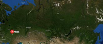
Pavlovo is a small town on the Oka River in the Nizhny Novgorod region. The first mention of the city dates back to the 16th century. Historically, crafts related to metal processing developed in Pavlovo: blacksmiths, tinsmiths, coppersmiths and others. Pavlovo became famous as a center for the production of locks, forks and knives. The city is home to the Pavlovsk Bus Plant, which produces PAZ buses. Also, the city of Pavlovo gained fame in connection with the cultivation of indoor lemons, which are now widespread far beyond the city.
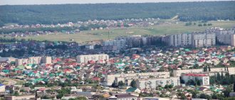
Pavlovo on the Oka is often called the pearl of the Nizhny Novgorod region, distinguished by its originality and charm. The city is spread out on seven hills - Trinity and Semenova, Spasskaya and Ubogaya mountains, Kamenka, Voskresenskaya and Dalnyaya steep.
Pavlovo on the map of Russia, geography, nature and climate
Location and geography of Pavlovo:
- in the north-west of the Volga Upland, in the Starodubye ;
- city blocks are located on the slopes of the Peremilov Mountains , on the right bank of the Oka River ;
- the territory (43 sq. km) is hilly, indented by ravines and ravines;
- within the city there are 7 hills called “mountains”, the central part is in the lowlands.
Features of the local relief are clearly visible on the map of Pavlovo from a satellite. The city is located in a temperate continental climate zone:
- winters are traditionally cold, the average January temperature is 10°C, the minimum recorded temperature is 34.1°C;
- summer is warm, the average July temperature is + 20°C, the maximum summer temperature record is +38.7°C;
- precipitation is usually caused by cyclones from the west.
Routes on the map of Pavlovo. Transport infrastructure
The city is crossed by the P125 , connecting Nizhny Novgorod with Kasimov. Pavlovo is connected by bus routes to Moscow and the regional center. Suburban communication has been developed.
The Metalist railway station is located in Pavlovo - the terminus on the branch connecting the city with the Okskaya station. Commuter trains and freight are transported along this dead-end line.
More than a dozen bus routes provide passenger transportation within the city.
It is possible to cross between the two banks of the Oka using a ferry and a pontoon bridge.
City name
In all historical documents there are two versions of the name of the city - Pavlov Ostrog and Pavlov Perevoz. The following legends are associated with these names:
- In the middle of the 16th century, after the conquest of the Kazan and Astrakhan khanates by Ivan the Terrible, the threat of attack by the Crimean Tatars and steppes remained. For this reason, fortified cities were built along the border of the Moscow principality. By order of Tsar Ivan the Terrible, a guard fortress was built on the steep bank of the Oka, in the area of Spasskaya Mountain, from where the area was clearly visible in the southern and southeastern directions. Its garrison consisted of 50 archers, headed by the archery centurion, after whom the fortress was named - Pavlov fort
- There is also a legend about the ferryman Pavel, who lived on the banks of the Oka and was engaged in transportation. In all likelihood, even before the construction of the fortress, a crossing over the Oka River was established near the modern market, through which the Russian population living along the Klyazma River was connected with the Mordovian tribes living in this area. In the area of the crossing there was an inn and a forge for shoeing horses; fairs were held here, fishermen, boatmen and timber raftsmen worked here. Perevoz appeared in this place long before the founding of the fortress - only this can explain that for a century the name Pavlov Perevoz was used along with the name of the city Pavlov Ostrog.
Sights of the city of Pavlovo
In modern Pavlovo, historical buildings have been preserved, mainly mansions of wealthy Pavlovsk residents, built in the 18th and 19th centuries.
Among the main attractions of the city are museums, architectural monuments, and temples. Their location is clearly shown on the map of Pavlovo with houses.
Museums
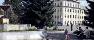
The Pavlovsk Historical Museum has existed for more than 80 years; it used to be called the Industrial Museum. It is located in the historical part of the city, among ancient buildings. The museum halls are located in the house of the merchant Gomulin - an estate of the 19th century, which is an architectural monument of regional significance; a quarter of the museum funds are made of metal: unique collections of knives and locks.
In the City Exhibition Hall you can see works of decorative and applied art, works by local artists.
Monuments
Of interest are both ancient sights and modern monuments in honor of famous people and events:
- Architectural monuments - the estate office of the Sheremetev counts , the house (in the Art Nouveau style) of the manufacturer Terebin, the building of the volost government.
- Religious buildings – Ascension Cathedral , Church of the Resurrection.
- Pavlovsk lemon is a monument dedicated to the achievements of local breeders who developed a variety of indoor citrus.
- Monument to Favorsky - academician, famous organic chemist. Located in the park of the same name.
- Monument to Pavlovsky blacksmith on Krasnoarmeyskaya street.
- Monument to “Kopeyka” - a VAZ-2101 traffic police patrol car.
- Monument to the first PAZ 651 - near the entrance of the Pavlovsk bus plant.
Parks Pavlovo
The favorite vacation spot for Pavlovsk residents is the Dalnyaya Krucha :
- the oldest in the city, the main part of it still retains a regular layout;
- from the high bank of the Oka River a panorama of Pavlovo and its surroundings opens;
- Linden and maple plantings predominate; chestnut, birch and ash grow.
Another green area of the city is the arboretum of the Pavlovsk mechleskhoz:
- natural monument of regional significance;
- laid down in 1958;
- the collection includes more than 140 species of shrubs and trees, including rare species.
PAVLOVO
PAVLOVO, a city in Russia, in the west. parts of the Nizhny Novgorod region, the center of the Pavlovsk district. Us. 59.5 thousand people (2013). Located on the slopes of the Peremilovsky Mountains, on the river. Oka (pier). Railway Art. Metalhead. The highway Nizhny Novgorod – Navashino – Murom (Vladimir region) – Kasimov (Ryazan region) passes through P.
It was first mentioned in a decree from the order of the Kazan Palace on April 6, 1565 as the palace village of Pavlovo. Sometimes it was also called Pavlov's Transport. In the 2nd half. 16 – 1st quarter. 17th centuries here there was a wooden-earth fortress Pavlov Ostrog. In 1622 the village was donated by Tsar Mikhail Fedorovich to Prince. I. B. Cherkassky, in 1642–44 a palace village, from 1644 it belonged to the prince. Y. K. Cherkassky and his descendants, in 1743 (finally in 1747) as a dowry for Princess V. A. Cherkasskaya passed to her husband, gr. P.B. Sheremetev, and their descendants. From the 2nd half. 17th century The steel industry was actively developing in Petrograd - the production of bladed weapons and firearms, knives, scissors, and weight rockers. Pavlovian padlocks became widespread. Rope spinning, tanning, soap making, lard making, and icon painting were developed. At 19 – beginning. 20th centuries P. is the center of the largest handicraft metalworking district in the country, Pavlovsk, which included St. 200 villages and hamlets of Nizhny Novgorod and Vladimir provinces. In 1894–1904, a printed organ of the volost self-government was published in Pavlovsk (a unique case in the Russian Empire) - “Actions of the Bodies of the Pavlovsk Peasant Society.” In 1900, one of the first metrological centers in the country was opened. institutions - calibration tent for trade weights and measures. To the beginning 20th century P. became the largest rural settlement in Nizhny Novgorod province. (1852 yards in 1911), the largest enterprises at that time were the factory of the brothers A. M. and V. M. Terebin (opened as a metalworking establishment in the 1850s), the famous Pavlovsk handicraft artel (founded by A. G. Stange in 1890; now “Pavlovsk Order of Honor Factory of Artistic Metal Products named after Kirov”).
Sov. power in Petrograd was established on October 28 (November 10), 1917. Since 1919 the city. District town of Nizhny Novgorod province. (1919–29; locally decided in 1918). In 1927, railway traffic was opened. Line Metalist (Pavlovo) - Okskaya. Since 1929, the regional center of the Nizhny Novgorod (from 1932 Gorky) region (1929–36), from 1936 the Gorky (from 1990 Nizhny Novgorod) region. In 1932, the Automotive Tools Plant (now the Pavlovsk Bus Plant) was put into operation, and in 1940, Plant No. 467 of the People's Commissariat of Aviation. industry of the USSR (now “Gidroagregat”). In Vel. Otech. During the war, evacuation hospital No. 1743 operated in Petrograd, and the 106th department was formed. shooter brigade (Dec. 1941 – Apr. 1942).
Pavlovo. Resurrection Church. 1777–78. Photo by P. S. Pavlinov
Pavlovo. House of V.I. Gomulin (now the Historical Museum). 1885. Photo by P. S. Pavlinov
In the center of the city, the historical part has been partially preserved. development. Among the main architects. dominant: 5-domed Resurrection Church. (1777–78) and Baroque with elements of classicism, Voznesenskaya Ts. (1795). Among the early citizens. and residential buildings: the Sheremetev estate office (last third of the 18th century), residential buildings (late 18th – mid 19th centuries). After the fire of 1872, in the spirit of eclecticism, the building of a craft school was erected (1895), Society. house with commercial premises (1897). Residential buildings of this time are often decorated with tower bay windows, patterned brickwork, balusters, wrought iron grilles: the estate of the merchant V.I. Gomulin (1885; now the Historical Museum), etc. Among the trees. houses 19 – beginning 20th centuries: 2-storey house of the 19th century, in which the chemist A.E. Favorsky was born; house of industrialist A. M. Terebin (1910). The Spartak cinema was built in the style of late constructivism (1937; now an entertainment center), Soviet. neoclassicism - Palace of Culture (1950s). Church in honor of the icon of the Mother of God “Joy of All Who Sorrow” (2000). Historical museum (founded in 1936). People's College artist industries (founded in 1945, current status since 2004).
Important industrial center of the Nizhny Novgorod region Leading enterprises: Pavlovsk Bus Plant (now part of the GAZ Group; a large Russian manufacturer of small and medium-sized buses of the PAZ brand), Gidroagregat and mechanical engineering. Voskhod plant (1946) (both produce equipment for aircraft, rocket and space technology). Production of gardening tools, snow removal equipment (“Mechanical Tools”), pneumatic tools (Russian-American enterprise “Instrum-Rand”), etc. Art Center. metalworking (“Pavlovsk Order of Honor Factory of Artistic Metalware named after Kirov” is a large Russian manufacturer of cutlery made of stainless steel, silver, including those with gilding).
Main streets of Pavlovo
There are 360 streets in the city of Pavlovo, the main ones are:
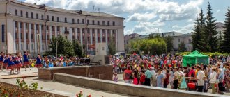
- Kommunisticheskaya - at the beginning it intersects with Mayakovsky Street, at the end - with Dorozhnaya. On this street are the City Administration, the Palace of Culture, and nearby is the Green Park and the airplane monument.
- Chkalova - starts from the intersection with Chapaev Street and lasts to the border with Ilyich Alley. It intersects with Favorsky Street, one of the most green in the city. Not far from Chkalova Street there is a cozy Favorsky square.
- Ilyich Alley - lasts from the border with Chkalov Street to the city outskirts. The decoration of the street is the Rowan Grove park, and not far away, already outside the city limits, is the Sosenki forest. There are many retail establishments on Ilyich Alley, including large chains (Pyaterochka, Magnit).
It’s easy to find the desired object in the city using a map of Pavlovo with streets.
Houses of Soplyakovs and Maklakovs
At No. 12 is another apartment building that belonged to the heirs of the merchant A.M. Maklakova. Both monuments were built at the beginning of the 20th century. The Maklakovsky house is a solid brick building with white stone inserts.
Closely adjacent to it is house No. 14, which belonged to the family of sausage merchant M.V. Soplyakov from the 1880s-1890s. Thanks to its location on the corner of Bazarnaya Square (the latter, together with Central Square and Lunacharsky Street connecting them, forms Pavlov’s modern “downtown”), the Soplyakovs’ house becomes an important city-forming accent. Its undoubted artistic merits - an asymmetrical thirteen-window façade, an openwork cornice and a figured attic - only emphasize the importance of this architectural monument in the modern development of the city.
Economy and industry Pavlovo
Pavlovo is considered a center of metalworking - the city has established the production of products using artistic forging. Pavlovo is also known for its mechanical engineering products:
- open joint-stock company "Pavlovsky Bus" - produces small and medium-capacity PAZ buses and spare parts for them;
- open joint-stock company "Gidroagregat" - production of products for the aerospace industry;
- machine-building plant Voskhod – also develops and produces equipment for the aerospace industry;
- Pavlovo enterprises produce metalworking tools, road and welding equipment, engineering access control systems, and metal structures.
The products of food industry enterprises satisfy the needs of consumers in the city and region.
Map
| Pavlovo: maps |
Pavlovo: photo from space (Google Maps) Pavlovo: photo from space (Microsoft Virtual Earth)
| Pavlovo. Nearest cities. Distances in km. on the map (in brackets along roads) + direction. Using the hyperlink in the distance , you can get the route (information courtesy of the AutoTransInfo website) | |||
| 1 | Tumbotino | 6 (7) | NW |
| 2 | Vorsma | 12 (13) | IN |
| 3 | Sosnovskoe | 17 (17) | YU |
| 4 | Gorbatov | 20 (29) | WITH |
| 5 | Vacha | 24 (31) | SW |
| 6 | Ilyinogorsk | 31 (71) | WITH |
| 7 | Bogorodsk | 32 (33) | NE |
| 8 | Volodarsk | 32 (87) | WITH |
| 9 | Reshetikha | 32 (93) | NE |
| 10 | Gorokhovets | 35 (48) | NW |
| 11 | Novosmolinsky | 37 () | WITH |
| 12 | Dzerzhinsk | 39 (87) | NE |
| 13 | Mulino | 41 () | WITH |
| 14 | Gremyachevo | 62 (148) | YU |
| 15 | Bolshoye Kozino | 64 (105) | NE |
| 16 | Hydropeat | 65 () | NE |
| 17 | Far Konstantinovo | 65 (129) | IN |
| 18 | Vyazniki | 65 (92) | NW |
| 19 | Kulebaki | 68 (111) | SW |
| 20 | Nikologory (Vladimir region) | 69 () | Z |
| 21 | Balakhna | 69 (106) | NE |
| 22 | Zhdanovsky | 70 () | NE |
| 23 | Nizhny Novgorod | 70 (82) | NE |
| 24 | Navashino | 71 (81) | SW |
| 25 | Kstovo | 73 (90) | IN |
| 26 | Bor | 76 (104) | NE |
| 27 | Arzamas | 77 (166) | SE |
| 28 | Outcall | 77 (169) | SE |
| 29 | Moore | 77 (87) | SW |
| 30 | Trans-Volga region | 78 (129) | WITH |
| 31 | Talitsy (Ivanovo region) | 78 (310) | NW |
a brief description of
The city is located on the slopes of the Peremilov Mountains, on the right bank of the Oka (pier), 78 km southwest of Nizhny Novgorod. Railway Metalist station.
The indoor lemon and tangerine cultures bred in Pavlovo became famous.
Territory (sq. km): 43
Information about the city of Pavlovo on the Russian Wikipedia site
Historical sketch
It was first mentioned in 1566 as Pavlovsk Ostrog. Subsequently known as the palace village of Pavlovo, or Pavlov Ostrog. Who Paul was, whose name the city bears, is not indicated in the sources. According to legend, it was founded on the Moscow-Nizhny Novgorod road by the ferryman Pavel. It was known from the beginning as Pavlov Perevoz, after the construction of the fortress - Pavlov Ostrog.
In 1621 it was donated to Prince Cherkassy, in 1742 the village passed through the family line into the possession of the Sheremetev garaf.
In the 18th century Pavlovo is a wealthy commercial and industrial village, whose residents were mainly engaged in the lock-and-knife trade. Pavlovsky locks (padlocks and chest locks) and guns were especially famous. In addition to metalworking, residents were engaged in leather production, weaving ropes and lace.
The village of Pavlovo was located in the Gorbatovsky district of the Nizhny Novgorod province.
Since 1919, the district city of the Nizhny Novgorod province, since 1919 the regional center of the Nizhny Novgorod region (Gorky), later - the Gorky region.
Municipal indicators
| Index | 2001 |
| Demography | |
| Number of births, per 1000 population | 7.7 |
| Number of deaths, per 1000 population | 18.7 |
| Natural increase (decrease), per 1000 population | -11.1 |
| Standard of living of the population and social sphere | |
| Average monthly nominal accrued wages, rub. | 2141 |
| Average housing area per inhabitant (at the end of the year), sq.m. | 20.5 |
| Number of preschool institutions, pcs. | 27 |
| Number of children in preschool institutions, thousand people | 2.7 |
| Number of daytime educational institutions (at the beginning of the school year), pcs. | 12 |
| Number of students in daytime educational institutions, thousand people | 8.2 |
| Number of doctors, people. | 245 |
| Number of nursing staff, people. | 800 |
| Number of hospital institutions, pcs. | 7 |
| Number of hospital beds, thousand units | 1.1 |
| Number of medical outpatient clinics, pcs. | 4 |
| Capacity of medical outpatient clinics, visits per shift, thousand units. | 3 |
| Number of registered crimes, pcs. | 1541 |
| Persons who committed crimes were identified, persons. | 555 |
| Economy, industry | |
| Number of enterprises and organizations (at the end of the year), pcs. | 2077 |
| Construction | |
| Volume of work performed by type of activity “Construction” (until 2004 - volume of work performed under construction contracts), million rubles. | 83 |
| Commissioning of residential buildings, thousand sq.m. of total area | 6 |
| Commissioning of residential buildings, apartments | 23 |
| Commissioning of preschool institutions, places | 0 |
| Commissioning of educational institutions, places | 0 |
| Commissioning of hospital facilities, beds | 0 |
| Commissioning of outpatient clinics, visits per shift | 0 |
| Transport | |
| Number of bus routes (in intracity traffic), pcs. | 10 |
| Number of passengers transported by buses per year (in intracity traffic), million people. | 18.1 |
| Connection | |
| Number of residential telephone sets of the city public telephone network, thousand units. | 4.3 |
| Trade and services to the population | |
| Retail trade turnover (in actual prices), million rubles. | 905.8 |
| Retail trade turnover (in actual prices), per capita, rub. | 13071.4 |
| Public catering turnover (in actual prices), million rubles. | 31 |
| Volume of paid services to the population (in actual prices), million rubles. | 135.2 |
| Volume of paid services to the population (in actual prices), per capita, rub. | 1951.2 |
| Volume of household services to the population (in actual prices), million rubles. | 6.3 |
| Volume of household services to the population (in actual prices), per capita, rub. | 91.5 |
| Investments | |
| Investments in fixed assets (in actual prices), million rubles. | 153.3 |
| Share of investments in fixed assets financed from budgetary funds in the total volume of investments, % | 10.9 |
Data sources:
- Regions of Russia. Main characteristics of the constituent entities of the Russian Federation: statistical collection. Goskomstat of Russia. - M:, 2003.
Economy
Pavlovo is a center of metalworking and mechanical engineering.
Factories: bus (PAZ buses), metalworking tools, metal products (the former Pavlovsk handicraft artel - the first in Russian metalworking, founded in 1890 by A.G. Stange), artistic metal products.
NPO "Mekhinstrument", Pavlovsk production association and territorial production association "Rosinstrument" (production of metal products). Dairy plant, meat processing plant and other enterprises.
In the Pavlovsk region, grains, potatoes, and vegetables are grown. Meat and dairy cattle breeding, poultry.
Deposits of gypsum, limestone, dolomite, marl, clay, sand, peat, etc.
Main enterprises
AUTOMOTIVE INDUSTRY
OJSC "Pavlovsky Bus" (PAZ)
606130, Nizhny Novgorod region, Pavlovsky district, Pavlovo, st.
Suvorova, 1 Offers:
buses and spare parts for them, technological equipment
MEDICAL INDUSTRY
OJSC "Medical Instrument Plant named after.
M. Gorky" 603131, Nizhny Novgorod region, Pavlovsky district, Tumbotino town, st.
Pushkina, 1 Offers:
medical instruments
Culture, science, education
Evening department of Nizhny Novgorod Polytechnic University.
Museum of Local Lore (opened in the 1930s).
Pavlovo is the birthplace of organic chemist A.E. Favorsky, botanist-traveler N.M. Albova and others.
Universities of the city
Pavlovsk branch of Nizhny Novgorod State Technical University named after.
R.E. Alekseeva 606100, Nizhny Novgorod region, Pavlovsky district, Pavlovo, st. Maxim Gorky, 23 WWW: https://pfngtu.ucoz.ru/
Museums, galleries, exhibition halls
Pavlovsk Historical Museum 606100, Nizhny Novgorod region, Pavlovsky district, Pavlovo, st. Krasnoarmeyskaya, 6 Phone(s): (83171) 3-45-05
Architecture, sights
The city has largely preserved its historical layout and development, with a clearly defined historical center.
The following churches have survived: Resurrection (1778), Ascension (1795). The former estate of merchant V.I. Gomolina (now a museum), the residential building of the manufacturer Terebin, the Sheremetevs' patrimonial office, the building of the volost government, etc.
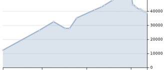
| Population by year (thousands of inhabitants) | |||||||
| 1897 | 12.4 | 1979 | 68.4 | 2003 | 64.8 | 2014 | 59.0 |
| 1931 | 20.6 | 1982 | 69 | 2005 | 63.2 | 2015 | 58.6 |
| 1939 | 32.4 | 1986 | 71 | 2006 | 62.5 | 2016 | 58.4 |
| 1959 | 47.9 | 1989 | 71.5 | 2007 | 61.7 | 2017 | 58.2 |
| 1962 | 55 | 1992 | 72.2 | 2008 | 61.1 | 2018 | 57.6 |
| 1967 | 60 | 1996 | 71.7 | 2010 | 59.9 | 2019 | 57.0 |
| 1970 | 63.2 | 1998 | 71.3 | 2011 | 60.7 | 2020 | 56.7 |
| 1973 | 66 | 2000 | 70.4 | 2012 | 60.0 | 2021 | 56.1 |
| 1976 | 68 | 2001 | 69.8 | 2013 | 59.5 | ||