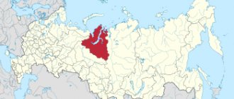
This peninsula is located in the north-west of the Russian Federation, and is part of the Murmansk region. It is washed by the Barents Sea in the north, and the White Sea in the east and south. The western border of the peninsula is a meridional depression that stretches from the Kola Bay along the Kola River to Kandalaksha Bay.
Its area is 100 thousand square kilometers, the northern coast is steep and high, and the southern coast is flat and low-lying, gently sloping. In the west of the peninsula there are mountain ranges - the Khibiny and Lovozero tundras. In its center stretches the Keiva ridge.
Climatic conditions
The Kola Peninsula has a very diverse climate. The warm North Atlantic Current warms it in the northwest. Here the climate is milder, subarctic, maritime. Closer to the east, center and southwest of the territory, continentality increases - here the climate becomes moderately cold. The average January temperature ranges from -10 °C in the northwest to -18 °C in the center. In July the air warms up from +8 °C to +10 °C.
The snow cover is completely established in early October, and disappears only at the end of May (in the mountains this process drags on until mid-June). Frosts and snowfall are common even in summer. Strong winds often blow on the coast (up to 55 m/s); in winter, prolonged snowstorms are a common occurrence.
History of the peninsula
Experts divide it into four main stages. The first began even before the Russians arrived on the Kola Peninsula. At that time, the indigenous population lived here - the Sami. They were engaged in deer hunting, berry picking, and fishing. The Sami lived in huts with a flat roof - tupas, or in huts made of reindeer skins - kuvaks.
The second historical period begins in the eleventh century, with the appearance of the first Pomeranian settlements. Their inhabitants did the same things as the Sami, but, unlike them, they rarely went hunting.
They lived in ordinary Russian huts, but with very narrow windows. They were necessary to retain heat as much as possible. Solid pieces of ice were installed in these narrow windows. When it thawed, a strong connection with the tree was formed.
The third historical period of the Kola Peninsula can be considered wars against invaders. The indigenous population has been interfered with by the Norwegians since ancient times. Since ancient times they have laid claim to the lands of the Sami. They had to fight them to defend their territory. The British began to lay claim to the peninsula after the Norwegians. In the 17th and 18th centuries, they burned Kola, a fortress built at the mouth of the river of the same name.
The fourth stage in the history of the peninsula is entirely connected with the emergence of the city of Murmansk. The first prospectors appeared in these places in 1912. Today it is the largest port in the Arctic.
Cities of the Kola Peninsula
The first settlement of Pomors, which appeared on the territory of the present city of Kola, appeared in 1264. It is mentioned in the notes of Simon van Salingen, a merchant from Holland in the 16th century.
At this time, the Pomors began active trade with the Norwegians, Swedes, British, and Danes, who arrived by ship on the Kola Peninsula. The city of Kola became the administrative center. Its population was engaged in fishing, breeding poultry and cattle.
In 1814, the first stone church on the peninsula was built here. The townspeople became famous for fearlessly repelling the attacks of the Swedes and the British.
Plus three hundred years
In Soviet times, historians Ivan Ushakov and Igor Shaskolsky found published notes by the Dutch merchant Simon van Salingen, in which he describes Kola in 1565 as a settlement in its infancy and consisting of only three courtyards. It is the year 1565 that today is considered to be the first mention of Kola - this principle is used by the Soviet school of historiography when establishing the dates of the founding of settlements. This date is also indicated on the stele at the entrance to the city.
However, data has recently been published that back in the 13th century, the Novgorod mayor of Alexander Nevsky, Valit Korelyanin, following the order of the Grand Duke, erected a stone fortification in Ust-Kola in 1264. It was a “stone fence of twelve walls,” which was called “Babylon.” This structure was subsequently dismantled during the construction of the Kola fort in 1583 at the confluence of the Kola and Tuloma rivers. In other words, already in the 13th century Kola was an outpost of Novgorod Rus' in the Kola North. It had the “locking” function of two important trade routes, one of which along the Tuloma River led towards Finland and Sweden, and the other along the Kola River led to Karelia and Novgorod Rus'.
According to Metropolitan Mitrofan, Salingen’s data cannot be considered objective. The so-called “Finnish source” of 1556 in Swedish has recently been put into circulation, which indicates that in Kola already at that time the population numbered “like five church parishes.” At that time, parishes were the name given to settlements that were able to maintain a church. For this, the parish had to consist of 100-120 people. If there were five church parishes in Kola, it means that at least 500-600 people lived there.
Already in the 13th century, Kola was an outpost of Novgorod Rus' in the Kola North
The ancient age of Kola is also beyond doubt because this city was located near the great waterway that once connected the Kola and Kandalaksha bays. The historical source “The Book of the Big Drawing”, which describes the northern borders of Russia from the great Novgorod princes, reports that in the Middle Ages the Kola Peninsula was actually an island, which was separated from the mainland by the “Kola Sea Strait”. It is known that the enlightener of the Sami, Saint Theodoret of Kola, according to Prince Kurbsky, at the beginning of the 16th century came along the “great river Kola” from the Solovetsky Islands to the “wild Lapps” in the Kola Bay. The Kola River was called “great” for the reason that it was a large sea waterway passing through all of Lapland and leading to Karelia. Along this route, Karelians annually went fishing in small boats between Teriberka and Cape Kegor (the ancient name of Cape German on the Rybachye Peninsula).
Now this waterway does not exist, and the Kola River has become shallow. Satellite data show that a long process of uplifting Fennoscandia continues - the part of the earth's lithosphere on which Norway, Sweden, Finland, Karelia and the Murmansk region are located, the left bank of the Onega and Kena rivers in the Arkhangelsk region, the northern part of the Andoma Upland, the right bank of the Svir and Neva rivers in the Leningrad region regions, as well as the seas adjacent to these territories. Every year Fennoscandia rises by 11 millimeters - more than a meter in a hundred years. For this reason, at the beginning of the 16th century, the rivers of the Kola Peninsula were approximately five meters deeper than today.
“The charter of 1264 mentions the Novgorod volost of Koloperm near the Kola Bay,” emphasized Bishop Mitrofan. — Of course, if a volost exists, then it must have its own volost center. True, the charter does not say that Kola was this center. But there is no doubt that a settlement existed here already at that time. If we take 1264 as the founding date of Kola, it turns out that in 2024 the city will celebrate its 760th anniversary. And this is already solid! In any case, the Kola region definitely has this founding date, as the heir to the Koloperm volost.
By the way
There is another option for the founding date of the city. In 1532, Hieromonk Elijah, a confidant of Metropolitan Macarius, and Hierodeacon Theodorit, known as the enlightener of the Lapps, Theodoret of Kola, consecrated the Annunciation and St. Nicholas churches in Kola. According to the Metropolitan, the consecration of the temple can be considered the foundation of a full-fledged settlement. But we were talking about the consecration of two entire churches in Kola - winter and summer. If we consider this date as the founding of Kola, then in 2022 the city may celebrate its 490th anniversary. Confirmation of the correctness of this approach is the founding of another regional center of the Murmansk region - the city of Kandalaksha. It is from the moment of consecration of the first church that the existence of Kandalaksha begins. The Sofia Chronicle mentions that Theodoret of Kola in 1526 built the first Church of the Nativity of John the Baptist at the mouth of the Niva River. Today this year is considered the founding date of Kandalaksha. By the way, in 2022 Theodoret Kola turns 450 years old, and the Kandalakshans intend to erect a monument to the founder of their city. The design of the monument has already been prepared.
Murmansk
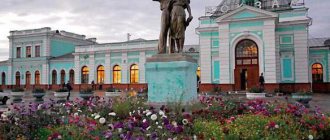
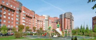
This largest city in the Arctic is located on the Kola Peninsula. It was founded in October 1916. At first it was called Romanov-on-Murman. The city bore this name until April 1917. It is located on the shores of the Kola Bay, 50 kilometers from the Barents Sea. It is surrounded by numerous hills.
Its area is 15,055 hectares (including the area of the Kola Bay - 1,357 hectares). The city consists of three administrative districts - Oktyabrsky, Leninsky and Pervomaisky.
Murmansk cannot be considered one of the largest cities in our country, but it is the largest city in the world located above the Arctic Circle.
In May 1985, he received the high title of “Hero City”, and in February 1971 he was awarded the Order of the Red Banner of Labor.
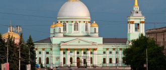
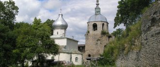
Annunciation Church
One of the attractions of modern Kola is the Annunciation Church. It is considered the oldest stone building on the entire Kola Peninsula.
At first I didn’t even understand what bothered me about the architecture of this church. I took a closer look. Typically, temples have domes placed on a cylindrical drum. And here a huge “onion” dome is planted directly on the base, the so-called quadrangle.
Scientists have found that the Annunciation Church used to form a single complex with the wooden Resurrection Cathedral of the late 17th century and the bell tower, which have not survived to this day. The local history museum displays a model of the cathedral. And in the church courtyard there is this model of a log wall.
In the courtyard of the temple there is a table like this with stools made from logs.
There is another attraction in the temple itself. This is the Wayward Cross.
Putny (bow) cross
The cross was installed in 1655 by the Kola governor G.I. Volyntsev at the ship pier. This cross was worshiped (hence the name - worship) by fishermen who went fishing at sea and merchants who brought goods to the Kola Peninsula. Local Pomors prayed to him and thanked him for saving his life during storms.
At the beginning of the twentieth century, the cross stood by the road, then it was demolished and for a long time nothing was known about it. Subsequently, the cross was found and installed right in the temple.
In 1974 it was recognized as an architectural monument of federal significance.
Apatity
The Kola Peninsula, photos of which can often be seen on the pages of publications for travelers, does not have many large cities on its territory. One of them is Apatity, with the territory under its jurisdiction, which includes the Khibiny station and the village of Tik-Guba.
The city is located between Lake Imandra and the Khibiny Mountains, on the banks of the Belaya River. Population: 57,905 people.
In 1916, a railway station appeared on the site of the current city, in connection with the start of road construction. In 1930, the state farm “Industry” was organized here.
The foundation of the city took place in 1951, and three years later the construction of the academic campus began. Due to the death of Stalin, work was suspended until 1956. Then the city began construction of the Kirov State District Power Plant. In 1956, the first residential building was put into operation.
In 1966 the city was reorganized. It included the village of Molodezhny.
Map
| Cola: cards |
Cola: photo from space (Google Maps) Cola: photo from space (Microsoft Virtual Earth)
| Cola. Nearest cities. Distances in km. on the map (in brackets along roads) + direction. Using the hyperlink in the distance , you can get the route (information courtesy of the AutoTransInfo website) | |||
| 1 | Kildinstroy | 9 () | YU |
| 2 | Murmansk | 9 (7) | WITH |
| 3 | Murmashi | 11 (11) | SW |
| 4 | Safonovo | 20 () | NE |
| 5 | Severomorsk | 24 (29) | NE |
| 6 | Snezhnogorsk | 36 (49) | WITH |
| 7 | Polar | 38 (57) | NE |
| 8 | Gadzhievo | 42 (62) | WITH |
| 9 | Vidyaevo | 50 () | WITH |
| 10 | Zaozersk | 62 (122) | WITH |
| 11 | Olenegorsk | 83 (92) | YU |
| 12 | High | 84 () | YU |
| 13 | Pechenga | 103 () | NW |
| 14 | Monchegorsk | 105 (124) | YU |
| 15 | Zapolyarny | 106 (145) | NW |
| 16 | Revda | 120 (159) | SE |
a brief description of
The city is located on the Kola Peninsula, beyond the Arctic Circle, at the confluence of the Kola and Tuloma rivers, near their confluence with the Kola Bay of the Barents Sea, 12 km south of Murmansk.
South-west of Kola, on the right bank of the river. Tuloma is the village of Murmashi, the northernmost balneological and mud resort in Russia.
Territory (sq. km): 172
Information about the city of Kola on the Russian Wikipedia site
Historical sketch
It was first mentioned as a Pomor settlement in 1264, Kolo volost. In 1565, the Kola fort was built, known as the city of Kola.
Named after its location at the mouth of the Kola River. A common etymology from the Finno-Ugric Kuljoki “fish river”. But since this form of the hydronym is not confirmed by any written source, an etymology from the Sami Koljok “golden river” is proposed. The Russians adopted the name first in the form of a semi-calculation of the Kola River, mentioned in the chronicle under 1532, which was then turned into the river. Cola. The Kola Peninsula got its name from the village of Kola and the Kola River.
In 1589-91. Residents more than once repelled attacks by the Swedes.
In the 15th-17th centuries. Kola is the starting point for fishing voyages to the islands of Spitsbergen (Grumant) and Novaya Zemlya. In the 18th century loses its importance as the center of foreign trade of the Moscow State in the North.
Since 1708 as part of the Arkhangelogorod province, since 1719 in the Arkhangelogord province. Since 1784, the district city of the Arkhangelsk governorship (since 1796 - Arkhangelsk province). From the second half of the 19th century. shabby city.
In 1856, in the district town of Kola, Arkhangelsk province, there was 1 church, 35 houses, 3 shops.
On March 15, 1926, it was transformed into the village of Kola, and later developed as a satellite of Murmansk.
Workers' settlement since August 20, 1935. City (secondary) since August 2, 1965.
Economy
Factories: furniture, pasta. Beer plant.
Near Kola there is a fur-breeding state farm.
Main enterprises
ELECTRIC POWER INDUSTRY
OJSC "Kolenergo"
184364, Murmansk region, Kola district, urban-type settlement Murmashi, st.
Kirova, 2 Offers:
electricity, heat
AVIATION TRANSPORT
JSC "Airport Murmansk"
184364, Murmansk region, Kola district, urban-type settlement Murmashi, Airport
Offers:
Air passenger and cargo transportation
Culture, science, education
Museum of Pomeranian Life (on display is a 17th-century worship prayer cross).
Universities of the city
Murmansk branch of the Moscow Academy of Entrepreneurship under the Moscow Government
184380, Murmansk region, Kola district, Kola, st. Andrusenko, 11 WWW: https://www.mosapkola.ru/
Architecture, sights
The earthen rampart and moat of the Kola fortress, one of the first stone buildings on the Kola Peninsula - the Annunciation Cathedral (1800-09), have been preserved.
In the vicinity of Kola there is a Neolithic site (2nd - 1st millennium BC).
| Population by year (thousands of inhabitants) | |||||||
| 1856 | 0.5 | 1992 | 16.1 | 2007 | 10.6 | 2016 | 9.7 |
| 1897 | 0.6 | 1996 | 12.4 | 2008 | 10.5 | 2017 | 9.7 |
| 1926 | 0.6 | 1998 | 12.2 | 2010 | 10.3 | 2018 | 9.7 |
| 1939 | 8.4 | 2000 | 11.9 | 2011 | 10.4 | 2019 | 9.7 |
| 1959 | 12.3 | 2001 | 11.8 | 2012 | 10.3 | 2020 | 9.7 |
| 1970 | 12.1 | 2003 | 11.1 | 2013 | 10.1 | 2021 | 9.6 |
| 1979 | 13.3 | 2005 | 10.8 | 2014 | 10.1 | ||
| 1989 | 16.5 | 2006 | 10.6 | 2015 | 9.9 | ||
polar night
Due to the fact that the Kola Peninsula is located beyond the Arctic Circle, the polar night reigns here from the end of November to the end of January.
The black sky is strewn with bright stars, the cities are illuminated by electric lanterns. At noon, the sky brightens a little, with purple, dark blue and even pink hues appearing on it. Thus two short hours of twilight pass. Then the sky darkens again.
Rivers of the peninsula
The reservoirs of this land are mainly fed by melt water (up to 60% of the flow). The rivers of the Kola Peninsula are deep for 2 months a year (May-June), and then they become significantly shallower. The water level in them largely depends on summer rains.
Their length exceeds 50 thousand km. They belong to the basin of two northern seas - the Barents and White. Some of them are more than 200 km long - Varzuga, Ponoy, Tuloma. They occupy 70% of the total area of the basins of the Murmansk region. Almost all rivers have a meridional flow direction; only the Ponoi River has a latitudinal flow.
Many rivers (Niva, Voronya, Umba, etc.) flow from large lakes. The water in them is usually greenish-blue and clear. During floods, rivers carry large amounts of silt, sand, and fallen leaves. The Kola Peninsula is characterized by long-term ice cover - 7 months, ice cover remains up to 210 days a year. The rivers open in May.
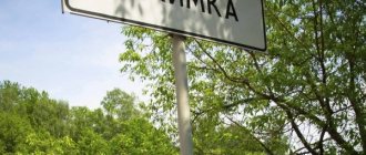
Cola
(Murmansk region)
OKATO code:
47205501
Founded:
1264
Urban settlement since:
1935
City since:
1965 City of district subordination (Kola district, Murmansk region)
Center:
Kola district
Telephone code (reference phone)
| 81553***** | — |
Deviation from Moscow time, hours:
0
Geographic latitude:
68°53′
Geographic longitude:
33°03′
Altitude above sea level, meters:
60 Sunrise and sunset times in the city of Kola
Hydro resources
On the rivers Tuloma, Niva, Kovda, Voronya there are hydroelectric power stations and reservoirs built. Unlike the lowland southern rivers, in the northern ones, due to the cooling of water on the rapids during the cold season, bottom ice forms.
The rivers of the Kola Peninsula are conventionally divided into four groups:
- semi-plain (Varzuga, Ponoy, Strelna);
- river-canals (Varzina, Niva, Kolvitsa);
- lake type (Umba, Drozdovka, Rynda);
- mountain type (Kuna, Malaya Belaya).
Fishing
The Kola Peninsula today is one of the most interesting places for true connoisseurs of trout and salmon fishing. It is well known all over the world as the best place for catching “noble fish”. Conventionally, fishermen divide the rivers of the peninsula into those that flow into the cold Barents Sea, and those that carry their waters to the White Sea.
Fishing on the Kola Peninsula is a pleasure not only for beginners, but also for experienced lovers of this activity. In July, a large number of not very large salmon – “tinda” – enter the rivers of the peninsula, and the August stocks contain medium-sized salmon.
This harsh region left its mark on the inhabitants of reservoirs. In many rivers there are no grayling, here they are replaced by Arctic char and whitefish.
River trout here grows to a very respectable size of five and sometimes seven kilograms, and brown trout does not exceed 2 kilograms.
The most famous rivers that attract fishermen from all over the country and from abroad to the Kola Peninsula (Russia), belonging to the northern shore, are Yokanga, Kola, Rynda, Kharlovka, Varzina, Vostochnaya Litsa. It is here that the best wild fishing on the Kola Peninsula is organized.
Pages of history
Let's see what Wikipedia tells us about Cola:
The administrative center of the Kola district of the Murmansk region, the historical center of the Kola Peninsula, a satellite city of Murmansk. The city is located at the confluence of the Kola and Tuloma , near their confluence with the Kola Bay of the Barents Sea, 12 km from the city center of Murmansk. The population is about 10 thousand people as of 2022.
Kola is considered the oldest city on the Kola Peninsula. Historians name two key dates associated with the founding of Kola:
- 1264 - Kolo volost is mentioned as a settlement of Pomors
- 1565 - the city of Kola, in which the Kola fort was built
There is no consensus on the etymology of the name itself. Everyone agrees that the settlement was named after the river on which it stood. Then why did the river itself get such a name?
Version one : from the Finno-Ugric Kuljoki, which translates as “fish river”.
Version two : from the Sami Koljok, which translates as “golden river”.
In any case, this name came into Russian as Kola River, which was later modified into Kola. Then the settlement was named Kola, and from the settlement the name passed to the whole peninsula.
Already under Ivan the Terrible, international trade emerged on the Kola Peninsula. In 1582, in response to the aggressive actions of Denmark, the tsar imprisoned the governor Averky, a monk Abraham Palitsyn, in the Kola prison. He was a famous writer and church leader. It was Abraham Palitsyn who established a guest house in Kola, a postal service, and introduced trade and fishing duties.
In the Murmansk Museum of Local Lore (it’s called the “Museum of History”) there is an entire hall dedicated to the history of the emergence and development of Kola. It tells about the daily life and activities of the Kolyans.
The harsh northern climate did not allow the Kolyans to grow grain crops. However, they harvested such a rich harvest of cabbage and turnips that they sold these vegetables to the Danes who lived on the coast.
Kola cabbage
Academician N.Ya. Ozeretskovsky, who studied the life of the Kolyans, wrote:
“The cabbage will be born well... but it will never curl into the forks, no matter how long it sits in the beds in the fall, and no matter how much frost twists and shrinks it; its leaves, rising upward, always diverge to the side and are wide and long. In this form, the Kolyana cabbage taken from the beds is not cut into sections, as is usually done throughout Russia, but whole leaves are boiled in water, and then placed in tubs, adding the same water in which it was cooked, but slightly salted. When it is necessary to cook, they chop it, and Kola cabbage soup is extremely tasty...”
Kolyans also collected cloudberries, which were in great demand throughout Russia. They rented entire islands from the local Lapp residents and collected berries. It turns out that cloudberries were even supplied to the imperial court!
But I couldn’t find cloudberries either in Murmansk or in Kola. Or rather, I saw green berries in Murmansk when I was walking along the hills. But I wanted to know what ripe cloudberries taste like. And I managed to try this amazing berry only a week later, already in the Arkhangelsk region, when I came to visit Svetlana Kharyusheva.
Of course, the residents of Kola were engaged in fishing, whaling , and carting.
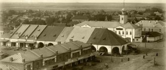
"Kola Tract": Kola - Kandalaksha
Kola was the crossing point of northern sea and land routes . It was here that the only road on the Kola Peninsula ended. It was called the “Kola Highway” and went from Kandalaksha to Kola. It connected the Kola Peninsula with the rest of Russia.
It was along this road that merchants and industrialists from all over Pomerania, scientists and Arkhangelsk governors came to Kola. In the spring they gathered in Kola, and then dispersed to the camps of the Murmansk coast. Local Lapp residents were engaged in transportation by land , and Russian shipowners were engaged in sea transportation .
The route was equipped with 10 road stations, the so-called “pits”.
This is what postal stations looked like at the beginning of the twentieth century.
In one of the halls of the History Museum in Murmansk, I discovered interesting statements about Kolya. If I worked as a history teacher now, I would definitely “hammer” this material for the lesson. There are so many interesting figures of speech - this is already the linguist in me speaking! - and facts on the basis of which you can come up with creative tasks!
Let's, for example, take one single phrase from this list: “From Kholmogory to Kola - thirty-three Nikolas.” And a cloud of questions immediately arises.
- Where are Kholmogory located?
- Why exactly from Kholmogory to Kola, and not to another locality?
- In what meaning is the name Nikola used?
- What does “thirty-three Nikolas” mean?
- Why exactly thirty-three?
- How would this phrase sound in modern Russian?
Yes, here you can easily do a real quest! Moreover, not only for students, but also for adults. For example, for those who come to Murmansk as a tourist. I would definitely take part!
Kharlovka River
This amazing river is well known to experienced salmon fishermen. In addition, travelers who appreciate the extraordinary northern nature often come here. They are attracted by the beautiful waterfall. Huge masses of water can lead to indescribable delight a person who has seen this stunning spectacle at least once.
Kharlovka is famous for its particularly large salmon and equally large trout. True, fish can pass through waterfall streams only if the water level in the river is appropriate. Sometimes anglers give up fishing and watch the salmon try to overcome this obstacle. In the white foam of water, the fish jumps out of the water. At the top of the waterfall there is a natural slab from which this process can be captured on film. Residents of the Kola Peninsula have long been no longer surprised by unique footage in which a huge fish seems to be flying into the camera lens.
Kharlovka has excellent fishing, which is why not only “savage” fishermen come here, but also high-quality organized tours are organized.