| Apartments in Russia | Excursions from Kaliningrad here | Car rental in Kaliningrad
Kaliningrad (formerly Königsberg) and the Kaliningrad region are the center of medieval architectural monuments. Teutonic castles, churches and extraordinary beauty of nature - that’s why you need to plan at least a week for Kaliningrad: there is something to be surprised by and where to wind hundreds of kilometers along the roads of hoary antiquity.
Where else in Russia can you find so many castles of the thirteenth century? Nowhere else, their coeval is only in Vyborg. So we plan our trips thoughtfully. As always, if you have the opportunity to rent a car, you can see much more in the same amount of time. You can rent a car here , the main thing is to do it in advance, because during the high season there may be very few options to choose from (or none at all).
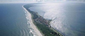
So, in the Kaliningrad region, two picturesque spits with trekking routes await us:
- Curonian Spit (national park and border with Lithuania),
- Baltic Spit (border with Poland).
Knight's castles of the 13th century:
- Preussisch-Eylau Castle (Bagrationovsk),
- Waldau Castle (Lower)
- Neuhausen Castle (Gurievsk)
- Lauken Castle (Saranskoye)
- Tapiau Castle (Gvardeysk)
- Georgenburg Castle (Chernyakhovsk)
Even more castles - only ruined ones:
- Lochstedt Castle (near Baltiysk)
- Ragnit Castle (Neman)
- Brandenburg Castle
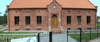
Medieval churches of the 13th century:
- Church of Pershken (XIII century, Novo-Moskovskoe village).
- Kircha Juditten (Kaliningrad).
Other picturesque, but more “youthful” churches:
- Kircha Arnau (XIV century, Rodniki village)
- Church of Heiligenwalde (XIV century, Ushakovo village)
- Church of Heiligenbeil (XIV century, Mamontovo village)
- Kirkha Tapiau (XVI century, Gvardeysk)
- Mennonite church (XIX century, Neman)
If you plan to travel on your own, there are two things to consider: the seasonal schedule and the huge number of excursions.
The seasonal schedule of trains and buses varies greatly. During the high season, additional modes of transportation become available (additional trains, ferries, etc.). So the most important thing when planning is an up-to-date schedule. If you want to see more, I highly recommend taking a look at the excursions. There are hundreds of excursion offers in the Kaliningrad region. And group tours - in them you will see much more than on public transport, while the cost is unlikely to be more expensive than the cost of buses and trains. There are also individual tours (here the price is, of course, higher, but it becomes possible to adjust the program to your own taste, the guides are always helpful!
When drawing up a rough plan for a trip around the Kaliningrad region, I show the maximum possibilities - for those who travel by car, I tell them what can be seen by public transport and recommend excursions that will help replace it. Go!
Content
- 1 Large cities 250-500 thousand people 1.1 Kaliningrad
- 2.1 Sovetsk (Kaliningrad region)
- 3.1 Guryevsk (Kaliningrad region)
General information about the Kaliningrad region
Distinctive features .
The Kaliningrad region is the smallest, westernmost and, probably, the most unique region in the Russian Federation. First of all, after the collapse of the USSR, it found itself cut off from the metropolis. This “Little Earth” is now surrounded by EU countries, which significantly complicates land transport between it and other regions of Russia. On the other hand, this region is an important outpost of Russia in the Baltic. In order to help the problem area with economic development, a free economic zone was created on its territory. Geographical location . The Kaliningrad region is sandwiched between Poland and Lithuania, and its north is washed by the waters of the Baltic Sea. These lands are famous for their amber, and it is here that the world's largest reserves of this unique material are located. Large areas of the region are located below sea level, so most of the region is covered by a network of drainage reclamation canals. Two large inland bodies of water are of economic importance - the Curonian and Kaliningrad Lagoons, where fishing is carried out.
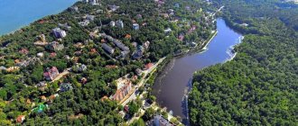
Embankment of the resort town of Zelenogradsk
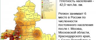
Population. Historically, Prussian tribes used to live on these lands. They did not harm anyone, bred horses and fought off the attacks of all sorts of adversaries. Then these lands were captured by the Teutonic Order, and for many centuries the Germans reigned here. After the victory over Nazi Germany, East Prussia was divided between Poland and the Soviet Union, which received only a small part of these lands in the form of the Kaliningrad region. Today, the national composition of the region looks like this: 86% Russians, 3.6% each Ukrainians and Belarusians, 1% Lithuanians and less than 1% Germans. As of 2013, the population was 954,773 people, with 47% men and 53% women. The population density is relatively low - 63.13 people/sq. m. Unfortunately, for the last ten years the population has remained unchanged, while there has been migration from small towns and villages to the regional center - Kaliningrad.
Crime . In the ranking of regions by crime level, the Kaliningrad region is in 46th place. Among the most typical crimes are the murders of entrepreneurs, illegal trafficking in weapons and drugs, and the smuggling of amber to European countries.
The unemployment rate in the Kaliningrad region is currently 9.1%. And although it was even higher in 2010, due to global economic conditions this figure is unlikely to decrease in the near future. In terms of wages, local residents can console themselves with the fact that they are higher than in the central regions of Russia (except for the capital, of course). Thus, in 2012, the average salary in the Kaliningrad region was 21,500 rubles.
Hotel Nesselbeck in Kaliningrad
The cost of real estate in the Kaliningrad region corresponds to the Russian average - 49 thousand rubles per sq. m. meter. In Kaliningrad itself, housing is quite expensive for local residents, who have to shell out 2 million rubles. for an apartment is an unaffordable luxury.
The climate of the Kaliningrad region is maritime and temperate continental. The coldest months are January and February, when the average temperature is −2.. −4°C. In summer it is quite cool here +17…+18°С. The average annual precipitation is 600-740 mm, with the greatest part falling in July and August. Therefore, despite the proximity of the sea, there is no smell of a resort here. Only 68 sunny days a year, as well as strong gusty winds in the fall, do not so much relax as they strengthen the soul of those who live here.
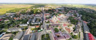
Small towns of less than 20 thousand people
Guryevsk (Kaliningrad region)
There are other settlements with this name, see Guryevsk.
Population 19,314 (2020).
Zelenogradsk
Population 16,536 people (2020).
Svetlogorsk
Population 15,208 (2020).
Gvardeysk
Population 13,313 (2020).
Pionersky
Population 12,194 (2020).
Neman
Population 10,756 people (2020).
Mamonovo
Population 8,014 (2020).
Polessk
Population 6,887 (2020).
Bagrationovsk
Population 6,388 (2020).
Pravdinsk
Population 4,025 people (2020).
Slavsk
Population 3,984 (2020).
Nesterov
Population 3,933 (2020).
Ladushkin
Population 3,886 people (2020).
Ozersk (Kaliningrad region)
There are other settlements with this name, see Ozyorsk.
Population 3,821 (2020).
Krasnoznamensk (Kaliningrad region)
There are other settlements with this name, see Krasnoznamensk.
Population 3,088 (2020).
Primorsk
Population 1,929 people (2020).
Kaliningrad
(Kaliningrad region)
OKATO code:
27401
Founded:
1255
City since:
1946 City of regional subordination
Center:
Kaliningrad region
Urban areas, population as of 01/1/2021
| Leningradsky | 180.9 | Moscow | 177.6 | Central | 134.7 |
| The city was formerly called: | ||
| Koenigsberg | 1255 | 1946 |
| Telephone code (reference phone) | |
| 4012****** | — |
Deviation from Moscow time, hours:
-1
Geographic latitude:
54°43′
Geographic longitude:
20°30′
Altitude above sea level, meters:
10 Sunrise and sunset times of the Sun and Moon in the city of Kaliningrad
see also
- Kaliningrad region
- Symbols and landmarks of the Kaliningrad region
- Cities of Russia
| [ + ] Cities by regions of Russia | |
| Cities of the North-West (NWFD) | St. Petersburg (and its cities) • Leningrad region (historical Staraya Ladoga) • Arkhangelsk region • Vologda region • Kaliningrad region • Karelia • Komi • Murmansk region • Nenets Autonomous Okrug • Pskov region |
| Cities of the Volga region (Volga Federal District) | Bashkortostan • Volgograd region • Kalmykia • Kirov region • Mari El • Mordovia • Nizhny Novgorod region • Orenburg region • Penza region • Perm region • Samara region • Saratov region • Tatarstan • Udmurtia • Ulyanovsk region • Chuvashia |
| Cities of Southern Russia (SFD) | Sevastopol (including Inkerman) • Republic of Crimea • Adygea • Astrakhan region • Krasnodar region • Rostov region |
| Cities of the North Caucasus (NCFD) | Dagestan • Ingushetia • Kabardino-Balkaria • Karachay-Cherkessia • North Ossetia - Alania • Stavropol Territory • Chechen Republic |
| Cities of the Urals (Ural Federal District) | Kurgan region • Sverdlovsk region • Tyumen region • Khanty-Mansi Autonomous Okrug - Yugra • Chelyabinsk region • Yamalo-Nenets Autonomous Okrug |
| Cities of Siberia (Siberian Federal District) | Altai Republic • Altai Territory • Irkutsk Region • Kemerovo Region • Krasnoyarsk Region • Novgorod Region • Novosibirsk Region • Omsk Region • Tomsk Region • Tyva • Khakassia |
| Cities of the Far East (FEFD) | Amur Region • Buryatia • Jewish Autonomous Region • Trans-Baikal Territory • Kamchatka Territory • Magadan Region • Primorsky Territory • Sakha (Yakutia) • Sakhalin Region • Khabarovsk Territory • Chukotka Autonomous Region |
| see also | Cities of the DPR, LPR, Transnistria, South Ossetia • Regions of Russia • Cities of Russia |
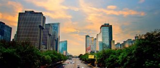
Kaliningrad is the beautiful capital of the region
Kaliningrad can immediately surprise you with such a structure as the Royal Gate. In the 20th century, they were sold to the city; they were rarely used, so there was no particular need. For the 750th anniversary of Kaliningrad, it was decided to restore the gate, making it one of the branches of the Museum of the World Ocean.
From the Royal Gate you can go straight to the Friedland Gate. This is a really interesting building and a popular tourist spot. The museum, organized in the building, displays an exhibition of found things. It is no secret that Kaliningrad has had to endure more than one purge, during which antiques were found. It is the Friedland Gate that can demonstrate them in all their glory. The museum also became famous thanks to the activities of the workers themselves, who very carefully and reverently created its collection. In the first hall, virtual streets await visitors; surrounded by projectors, guides will tell interesting moments in the history of Königsberg. Tourists note the atmosphere of the hall that exceeds expectations, as if plunging into the past. The Knights' Hall is dedicated to the history of the Teutonic Order. A lot of knightly uniforms are stored here. You can bypass the third hall, but if you like specific excursions, it’s also worth a visit. It is dedicated to the sewer system, which for a long time was simply absent in the Friedland Gate. The history of the issue, which affected not only the museum, but also many European cities, has been considered since ancient times.
The famous Fishing Village, beloved by locals and tourists, appeared only in 2006. It includes hotels, cafeterias and restaurants, shops, jewelry stores, a fish market and a tourist center. There are several observation towers that offer beautiful views. The main thing people love about the Fishing Village is its own atmosphere. Once upon a time, fishermen lived here, as the corresponding design reminds. You can feel the spirit of pre-war Königsberg by looking at the Gothic towers, lanterns and even ordinary benches.
You can take a pleasure stroll, admiring the park and the river, on Kant Island. Here is the grandiose Cathedral, built in the 14th century. Not only the building itself makes a pleasant impression, but also its museum. There is an arboretum nearby. There is also an interesting monument to Albrecht of Brandenburg on the island. In general, the spicy Kanta is suitable for romantics who like to take walks and have picnics. There are many scenic spots for photography.
But let's stop at the Cathedral. It is still unknown exactly when construction began. The generally accepted version is the beginning of the 14th century. The founder of the cathedral is Johannes Claret. There is the Kant Museum, as well as two chapels: Protestant and Orthodox. The exhibition helps to better learn about famous people of Königsberg; each visitor is offered a collection of coins and banknotes, as well as the opportunity to listen to the music of a mini organ.
Map
| Kaliningrad: maps |
Kaliningrad: photo from space (Google Maps) Kaliningrad: photo from space (Microsoft Virtual Earth)
| Kaliningrad. Nearest cities. Distances in km. on the map (in brackets along roads) + direction. Using the hyperlink in the distance , you can get the route (information courtesy of the AutoTransInfo website) | |||
| 1 | Guryevsk | 8 (7) | NE |
| 2 | Light | 23 (27) | Z |
| 3 | Zelenogradsk | 25 (32) | WITH |
| 4 | Ladushkin | 27 (29) | SW |
| 5 | Pionersky | 31 (45) | NW |
| 6 | Primorsk | 32 (33) | Z |
| 7 | Svetlogorsk | 32 (39) | NW |
| 8 | Gvardeysk | 37 (26) | IN |
| 9 | Bagrationovsk | 38 (39) | YU |
| 10 | Baltiysk | 38 (42) | Z |
| 11 | Amber | 39 (48) | NW |
| 12 | Polessk | 41 (48) | NE |
| 13 | Pravdinsk | 44 (53) | SE |
| 14 | Mamonovo | 45 (53) | SW |
| 15 | Slavsk | 83 (106) | NE |
| 16 | Chernyakhovsk | 85 (80) | IN |
| 17 | Sovetsk | 97 (108) | NE |
| 18 | Ozyorsk | 103 (112) | IN |
| 19 | Neman | 104 (120) | IN |
| 20 | Gusev | 110 (108) | IN |
a brief description of
Located on the Primorskaya Lowland, along the banks of the river. Pregolya, at its confluence with the Kaliningrad Bay, 1289 km west of Moscow. The port (non-freezing) is connected to the Baltic Sea by a deep-water canal (to the city of Baltiysk). Railway junction.
The climate is transitional from marine to moderate continental. The average temperature in January is -4, July is +16. Precipitation is about 700 mm per year.
Near the city there are climatic seaside resorts Svetlogorsk, Otradnoe, Zelenogradsk, Pionersky.
Territory (sq. km): 223
Information about the city of Kaliningrad on the Russian Wikipedia site
Historical sketch
It was founded in 1255 by the crusaders of the Teutonic Order as a stronghold during the conquest of the lands of the ancient Prussians and named Königsberg - the German “royal mountain” in honor of the Czech king Premysl II (aka Otakar II), who took an active part in campaigns against the Baltic Prussian tribes. It quickly became an important port city.
In 1525-1618. residence of the Prussian dukes. Since 1701, part of the Kingdom of Prussia.
During the Seven Years' War of 1756-63 it was taken by Russian troops (1758), until 1762 the center of the Russian General Government of East Prussia. Since 1871 part of Germany.
The main occupations of residents at the end of the 19th century. there was trade (export of bread and vegetables, import of sugar and tea) and fishing. There were machine-building, metallurgical and soap factories, candle and tobacco factories.
During the Great Patriotic War of 1941-45, the city was destroyed by more than 90%. On April 9, 1945, troops of the 3rd Belorussian Front stormed Königsberg.
By decision of the Potsdam Conference in 1945, Koenigsberg and the adjacent territory (about 1/3 of the former East Prussia) became part of the USSR. In 1946, it was renamed in honor of the Soviet party and statesman M.I. Kalinin (1875-1946).
In 2005, the 750th anniversary of the city was widely celebrated.
Municipal indicators
| Index | 1990 | 1999 | 2001 | 2003 | 2005 |
| Demography | |||||
| Number of births, per 1000 population | 11.7 | 6.7 | 6.9 | 8.5 | 8 |
| Number of deaths, per 1000 population | 8.8 | 12.5 | 15 | 16.7 | 17.1 |
| Natural increase (decrease), per 1000 population | 2.9 | -5.8 | -8.1 | -8.2 | -9.1 |
| Standard of living of the population and social sphere | |||||
| Average monthly nominal accrued wages, rub. | 0.268 | 1726 | 3628 | 6219 | 9651.3 |
| Average housing area per inhabitant (at the end of the year), sq.m. | 15.2 | 18.2 | 18.9 | 19.1 | 20.3 |
| Number of preschool institutions, pcs. | 156 | 106 | 97 | 95 | 94 |
| Number of children in preschool institutions, thousand people | 21.6 | 11.8 | 11.5 | 12 | 12.8 |
| Enrollment of children in preschool educational institutions (at the end of the year), as a percentage of the number of children of the corresponding age, % | 67.3 | 66.8 | |||
| Number of daytime educational institutions (at the beginning of the school year), pcs. | 54 | 65 | 73 | 72 | 69 |
| Number of students in daytime educational institutions, thousand people | 47.1 | 56.7 | 53.3 | 47.1 | 40.9 |
| Number of doctors, people. | 2400 | 2186 | 2318 | 2363 | 2400 |
| Number of nursing staff, people. | 6637 | 5083 | 4701 | 4663 | 4698 |
| Number of hospital institutions, pcs. | 29 | 31 | 31 | 31 | 33 |
| Number of hospital beds, thousand units | 6.9 | 6.1 | 6.1 | 5.8 | 5.6 |
| Number of medical outpatient clinics, pcs. | 36 | 43 | 50 | 52 | 69 |
| Capacity of medical outpatient clinics, visits per shift, thousand units. | 8.4 | 11.1 | 11.3 | 11.3 | 11.6 |
| Number of registered crimes, pcs. | 5932 | 10823 | 12341 | 11442 | 10935 |
| Persons who committed crimes were identified, persons. | 2090 | 4045 | 4516 | 2989 | 2590 |
| Economy, industry | |||||
| Number of enterprises and organizations (at the end of the year), pcs. | 1153 | 17140 | 20600 | 26174 | 45799 |
| Number of operating enterprises by type of activity: mining (at the end of the year), pcs. | 4 | ||||
| Number of operating enterprises by type of activity: manufacturing (at the end of the year), pcs. | 87 | ||||
| Number of operating enterprises by type of activity production and distribution of electricity, gas and water (at the end of the year), pcs. | 6 | ||||
| Volume of shipped goods of own production by type of mining (in actual prices), million rubles. | 15012.6 | ||||
| Volume of shipped goods of own production by type of manufacturing (in actual prices), million rubles. | 33588.5 | ||||
| Volume of shipped goods of own production by type of production and distribution of electricity, gas and water (in actual current prices), million rubles. | 5828.1 | ||||
| Construction | |||||
| Volume of work performed by type of activity “Construction” (until 2004 - volume of work performed under construction contracts), million rubles. | 0.135 | 437.5 | 448 | 769.5 | 3084.7 |
| Commissioning of residential buildings, thousand sq.m. of total area | 164 | 93 | 120 | 162 | 178 |
| Commissioning of residential buildings, apartments | 1020 | 1329 | 1394 | 1940 | |
| Commissioning of preschool institutions, places | 330 | 0 | 0 | 0 | 0 |
| Commissioning of educational institutions, places | 1176 | 216 | 0 | 0 | 0 |
| Commissioning of hospital facilities, beds | 223 | 0 | 0 | 42 | 42 |
| Commissioning of outpatient clinics, visits per shift | 1000 | 0 | 0 | 20 | 50 |
| Transport | |||||
| Number of bus routes (in intracity traffic), pcs. | 31 | 20 | 11 | 8 | 8 |
| Number of tram routes, pcs. | 10 | 10 | 8 | 8 | 7 |
| Length of operational tram tracks (at the end of the year), km | 45.4 | 47.3 | 47.3 | ||
| Number of trolleybus routes, pcs. | 6 | 6 | 6 | 6 | 5 |
| Length of operational trolleybus lines (at the end of the year), km | 47.4 | 48.3 | 48.3 | ||
| Number of passengers transported by buses per year (in intracity traffic), million people. | 93.1 | 104.9 | 104.1 | 104.7 | 13.2 |
| Number of passengers transported by trams per year, million people. | 59.3 | 63.5 | 64.2 | 57.4 | 29 |
| Number of passengers transported by trolleybuses per year, million people. | 28.7 | 31.7 | 30.2 | 26.6 | 11.9 |
| Connection | |||||
| Number of telephone sets of the city public telephone network, thousand units. | 55.3 | 106.5 | 123.3 | 129.8 | 148.8 |
| Number of residential telephone sets of the city public telephone network, thousand units. | 38.1 | 77.9 | 86.2 | 94.1 | 101.8 |
| Number of payphones of the city telephone network (including universal ones), pcs. | 924 | 419 | |||
| Trade and services to the population | |||||
| Retail trade turnover (in actual prices), million rubles. | 6896 | 9819 | 12616 | 21324.4 | |
| Retail trade turnover (in actual prices), per capita, rub. | 16196 | 23362 | 29428 | 50218.3 | |
| Index of physical volume of retail trade turnover, % compared to the previous year | 111 | 119.5 | |||
| Index of physical volume of public catering turnover, % compared to the previous year | 114 | 112.7 | |||
| Number of stores, pavilions (at the end of the year), pcs. | 220 | 136 | |||
| Sales area of shops, pavilions (at the end of the year), sq.m. | 23655 | 12798 | |||
| Volume of paid services to the population (in actual prices), million rubles. | 0.106 | 1574.6 | 3340.7 | 5856.8 | 9677 |
| Volume of paid services to the population (in actual prices), per capita, rub. | 0.3 | 3698 | 7948 | 13662 | 22789 |
| Volume of household services to the population (in actual prices), million rubles. | 0.032 | 174.6 | 314.6 | 527.8 | 864.4 |
| Volume of household services to the population (in actual prices), per capita, rub. | 0.078 | 409.9 | 748.5 | 1231.1 | 2035.6 |
| Investments | |||||
| Investments in fixed assets (in actual prices), million rubles. | 0.234 | 1277.5 | 3782.8 | 10220.5 | 17086.5 |
| Share of investments in fixed assets financed from budgetary funds in the total volume of investments, % | 14 | 11 | 19 | ||
Data sources:
- Regions of Russia. Main characteristics of the constituent entities of the Russian Federation: statistical collection. Goskomstat of Russia. - M:, 2003.
- Regions of Russia. Basic socio-economic indicators of cities. Statistical collection. Rosstat. - M:, 2005. p. 123
- Transport in Russia: Statistical collection. Goskomstat. - M:, 2003. pp. 110, 112, 120, 122
- Transport in Russia: Statistical collection. Rosstat. - M:, 2005. pp. 117, 119, 127, 129
- Regions of Russia. Basic socio-economic indicators of cities. 2006. Statistical collection. Rosstat. - M:, 2006. p. 123
Culture, science, education
University (founded in 1544 by the Prussian Duke Margrave Albrecht I).
Baltic State Academy of Fishing Fleet. Technical Institute of Fishing Industry and Economy.
Theatres: drama, puppet theaters.
Museums: historical and artistic, amber.
Botanical Garden. Zoo.
Architecture, sights
Among the surviving architectural monuments are the Cathedral (14th century) and the city gates (18th century).
About 1/3 of the city is occupied by parks, gardens, and public gardens. There are about 130 lakes and ponds.
Monument to F. Schiller (1910, sculptor K. Kauer), grave of I. Kant (born in Königsberg).
On Gvardeysky Prospekt there is a monument to 1,200 guardsmen who fell during the storming of Königsberg (1945-46).
| Population by year (thousands of inhabitants) | |||||||
| 1897 | 162 | 1982 | 370 | 2005 | 425.6 | 2015 | 453.5 |
| 1956 | 188 | 1986 | 389 | 2006 | 423.7 | 2016 | 459.6 |
| 1959 | 203.6 | 1989 | 401.3 | 2007 | 422.3 | 2017 | 467.3 |
| 1962 | 232 | 1992 | 410.7 | 2008 | 421.7 | 2018 | 475.1 |
| 1967 | 270 | 1996 | 422.1 | 2010 | 419.2 | 2019 | 482.4 |
| 1970 | 297.0 | 1998 | 426.3 | 2011 | 431.9 | 2020 | 489.4 |
| 1973 | 323 | 2000 | 424.4 | 2012 | 433.5 | 2021 | 493.3 |
| 1976 | 338 | 2001 | 421.7 | 2013 | 441.4 | ||
| 1979 | 354.8 | 2003 | 430.0 | 2014 | 448.5 | ||