The city of Novosibirsk, the capital of the Novosibirsk region, raised many questions among members of our community. People argued until their fingers were callused about the materials presented in the articles: nonsense, the author had never been to the city, a custom article. I would like to assure you in advance that no one orders articles from us. Everything is written on the initiative of the project’s author group, and according to the vector of community development. And the fact that the editors’ opinions sometimes do not coincide with the readers’ opinions is not surprising, because we are all different people, and, as we know, there is no ultimate truth.
Districts of Novosibirsk (city microdistricts)
Dzerzhinsky
on the map (Dzerzhinsky district, Novosibirsk) Located on the right bank of the Ob. The area of the district is 41.3 sq. km. The length of the region from north to south is 5 kilometers, from west to east - 5.5 kilometers. There are 220 streets and alleys in the Dzerzhinsky district, among which the main ones are: Dzerzhinsky Avenue, Aircraft Prospekt, Koshurnikova, Boris Bogatkov, Uchitelskaya.
Railway
on the map (Zheleznodorozhny district, Novosibirsk) The oldest in Novosibirsk. The first residential buildings appeared in 1893 in connection with the construction of the East Siberian section of the Siberian Railway. Until 1932, the area was called the Station part of the city. In August 1936, by the decision of the Novosibirsk City Council of Workers, Peasants and Red Army Deputies, the Kaganovichi District was formed. The district was renamed Zheleznodorozhny in 1957. On February 1, 2013, the Zheleznodorozhny District became part of the Central District. Territory - 8.3 sq. km.
Zaeltsovsky
on the map (Zaeltsovsky district, Novosibirsk) Zaeltsovsky district is located in the northwestern part of Novosibirsk. Territory – 83.0 sq. km. It includes a forest area of 1200 hectares, 3 rivers, 2 islands. More than 190 streets and alleys pass through the territory. The total length of streets is 162 km. Main streets: Dusi Kovalchuk, Krasny Prospekt, Kropotkina, Zhukovsky.
Kalininsky
on the map (Kalininsky district, Novosibirsk) The Kalininsky district was formed from part of the territory of the Dzerzhinsky district according to the Decree of the Presidium of the Supreme Soviet of the USSR dated October 20, 1980, in connection with the planning of the construction of large residential areas in the northern part of the city. In December 1997, the working village of Pashino was included in the district, which became a kind of enclave of the city.
Kirovsky
on the map (Kirovsky district, Novosibirsk) Located on the left bank of the city. Until 1930 - Bugrinsky district of the Novosibirsk district. The center is the village of Bugry, which was the largest among the surrounding villages. October 20, 1930 - By resolution of the Presidium of the All-Russian Central Executive Committee, the Zaobsky district was formed. December 2, 1934 - By resolution of the Presidium of the Novosibirsk City Council, the Zaobsky administrative district became Kirovsky. The renaming occurred after the report of the murder of S. M. Kirov. The area of the district is 52.0 sq. km.
Leninist
on the map (Leninsky district, Novosibirsk) The third largest and most populated district of Novosibirsk. Located on the left bank of the Ob. Territory - 70.3 sq. km. The main highways of the area are: Karl Marx Avenue, Vatutina Street, Stanislavsky Street, Titov Street, Station Street. The Leninsky district is connected to the right bank part of the city by a railway bridge across the Ob and two road bridges: Dimitrovsky and Kommunalny.
October
on the map (Oktyabrsky district, Novosibirsk) The district was founded in 1929. Before that it was called Zakamensky (since, relative to the central part, it was located behind the Kamenka River). This is one of the oldest parts of the city of Novosibirsk. Territory - 57.6 sq. km. Main streets: Bolshevistskaya, Vybornaya, Voskhod, Boris Bogatkova, Nikitina, Kirov.
Pervomaisky
on the map (Pervomaisky district, Novosibirsk) The area consists of several parts, separated by forests and railway tracks. One part of the area faces the M52 federal highway. A significant part of the area is occupied by the private sector. The area of the district is 69.3 sq. km.
Soviet
on the map (Sovetsky district, Novosibirsk) One of the administrative districts of the city of Novosibirsk, sometimes also called, after its most important part, Novosibirsk Akademgorodok. It is located in the south of the central part of the city on both banks of the Ob River and the Ob Sea. The area of the district is 76.7 sq. km. The most important streets are Lavrentieva Avenue, Morskoy Avenue, Primorskaya, Russkaya, Berdskoe Highway.
Central
on the map (Center, central district, Novosibirsk) Area of the district - 6.4 sq. km. Since February 1, 2013, the district has been merged with the Zheleznodorozhny and Zaeltsovsky districts into a single Central District
Churches, cathedrals and temples
Holy Spring Iskitim
Coordinates: N54°34.437′ E 83°21.288′ How to get there: by regular bus 49 km from Novosibirsk to Iskitim in 40 minutes.
A spring with healing water is located near the village of Lozhok, Iskitim region.
There is a legend that the water clogged here after the mass execution of prisoners in Siblag, a forced labor camp that was organized near these places in the 30-40s of the 20th century.
The spring was repeatedly blown up during the years of Soviet power, but it still continued to flow in this place. Now a church has been built near it, and the area near the source has been landscaped.
This is a popular place for parishioners to visit. Local residents have a tradition of coming to the holy spring during weddings.
St. Nicholas Church in the name of St. Nicholas the Wonderworker
Address: Iskitim, st. Collective, 1 Phone: 8 (3834) 36‑82-42, 8 (3834) 33‑83-43 Website: iskitimeparhia.ru Opening hours: Mon-Sun 8:00-19:00
The temple building was built from 1989 to 2013. On August 11, 2022, its consecration was carried out, Bishop Luka of Iskitim and Cherepanov was appointed ruling bishop.
The main shrine of the temple is the icon with the image of the Mother of God “Softening Evil Hearts,” transferred to the church from the Novosibirsk Metropolis.
Church in the name of St. Seraphim of Sarov
Address: Bolotninsky district, village. Turnaevo, st. Khokhlovka, 1
This temple is called “Siberian Kizhi” because it was built in 1912 on a stone foundation made of pine logs without nails.
Since 1940, the temple was closed and converted into a granary.
The church became operational again after renovation in 1998. Restoration work was carried out in the next decade under the leadership of architects A. I. Lykov and S. M. Klepikov.
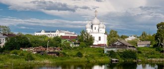
Alexander-Pokrovsky Convent
Address: town. Kolyvan, st. Kalinina, 22 Phone: 8 (3835) 25‑27-77 Website: kolivan-pokrov.ru Opening hours: Mon-Fri 8:30-17:00; Sat 8:30-19:00; Sun 8:00-18:00
The monastery in the village of Kolyvan was opened in 1992 on the initiative of Bishop Tikhon (Emelyanov) of Novosibirsk and Barnaul. Prior to this, in 1991, Patriarch Alexy II of Moscow and All Rus' visited this place and blessed the beginning construction of the monastery.
Now about 40 nuns and novices live and work in the monastery. A Sunday school has been opened at the monastery, where children of Kolyvan parishioners study.
In the church at the monastery there are such shrines as icons of saints Alexander Nevsky, Silouan of Athos, Innocent of Irkutsk, Tikhon, Patriarch of Moscow, Luke of Simferopol, Gury of Kazan, Philaret of Moscow, John of Tula and Nicholas of Alma-Ata with particles of relics, as well as a cross with a particle Life-giving Tree of Christ.
Suburban settlements of Novosibirsk
Berdsk
on the map (the city of Berdsk, a suburb of Novosibirsk) A city in the Novosibirsk region of Russia, part of the Novosibirsk agglomeration. Located south of Novosibirsk on the shore of the Novosibirsk Reservoir, it is the second most populous city in the Novosibirsk region. Founded in 1716 on the Berd River (the right tributary of the Ob) as the Berdsky fortress fortress. City since 1944.
Iskitim
on the map (city of Iskitim, suburb of Novosibirsk) City (since 1938) in the Novosibirsk region of Russia. The city of Iskitim forms the urban district and is also the administrative center of the Iskitim region. Part of the Novosibirsk agglomeration. The city is located on the Berd River (the right tributary of the Ob), 26 km south of Novosibirsk. Iskitim railway station is 57 km from Novosibirsk-Glavny station.
Ob
on the map (city of Ob, suburb of Novosibirsk) The city is located in the east of the Barabinskaya lowland, 5 km west of Novosibirsk and is connected with it by rail and road. Part of the Novosibirsk agglomeration. Railway station on the Trans-Siberian Railway. The area of the city according to 2008 data is 21.95 sq. km. Main enterprises: JSC Tolmachevo Airport
Krasnoobsk village
on the map (the village of Krasnoobsk, a suburb of Novosibirsk) Krasnoobsk (unofficial name - “VASKHNIL”) is an urban-type settlement in the Novosibirsk district of the Novosibirsk region. It was founded in 1970 as a settlement for workers of the then formed Siberian branch of the All-Russian Academy of Agricultural Sciences. The status of the village has been since 1976. Population - 19,775 people. (2013). Located on the left bank of the Ob between the Kirovsky and Sovetsky districts of Novosibirsk.
Mochishche village
on the map (Mochishche village, suburb of Novosibirsk) Located northwest of Novosibirsk. It borders with the Zaeltsovsky district.
Ozerny village
on the map (Ozerny village, suburb of Novosibirsk) Located north of Novosibirsk. The border of the Kalininsky district passes nearby.
p. Elite
on the map (Elite village, suburb of Novosibirsk) This village can be considered one of the oldest cottage villages in Novosibirsk. It was created for housing scientists of the Siberian Branch of the Russian Academy of Agricultural Sciences. Since its founding it has grown greatly. Now there are many modern houses and cottages on its territory. On the left bank of the Ob, “Elite” is now a kind of elite place to live - land plots and cottages are quite expensive there.
Kupino - on the outskirts of the region
Kupino, occupying 32 km², is one of the most remote from Novosibirsk: it is located 460 km to the southwest, almost at the borders of Kazakhstani territory. It is not surprising that before the period of active development of Siberia, the bulk of the population, along with the Siberian Tatars, were Kazakhs.
The settlers who came here in the late 19th and early 20th centuries founded about 60 villages, among which was Kupino. Its development was facilitated by the appearance of the railway, after which a fish factory and food processing plant opened.
Novosibirsk
(Novosibirsk region)
novosib_obl/novosibirsk/index.html
City of regional subordination Center:
Novosibirsk region
Center:
Novosibirsk district, Novosibirsk region
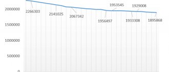
| Urban areas, population as of January 1, 2000 | |||||
| Dzerzhinsky | 156.8 | Kirovsky | 161.1 | Soviet | 131.2 |
| Railway | 69.1 | Leninist | 273.5 | Central | 73.6 |
| Zaeltsovsky | 144.2 | October | 152.0 | ||
| Kalininsky | 168.9 | Pervomaisky | 68.4 | ||
| The city was formerly called | ||
| New Village | 1893 | 1894 |
| Alexandrovsky | 1894 | 1895 |
| Novonikolaevsky | 1895 | 1903 |
| Novonikolaevsk | 1903 | 1925 |
| Telephone code | Help phone |
| 3832****** | 24-42-29 |
| Novosibirsk Nearest cities. Distances on the map (road), km, direction | |||||||
| 1 | Berdsk (Novosibirsk region) | 22 (. ) | YU | 8 | Yurga (Kemerovo region) | 146 (173) | NE |
| 2 | Ob (Novosibirsk region) | 27 (. ) | Z | 9 | Kamen-on-Obi (Altai Territory) | 171 (. ) | SW |
| 3 | Iskitim (Novosibirsk region) | 36 (. ) | SE | 10 | Novoaltaysk (Altai Territory) | 174 (215) | YU |
| 4 | Cherepanovo (Novosibirsk region) | 79 (. ) | YU | 11 | Kargat (Novosibirsk region) | 176 (. ) | Z |
| 5 | Toguchin (Novosibirsk region) | 101 (. ) | NE | 12 | Barnaul (Altai region) | 181 (229) | YU |
| 6 | Bolotnoye (Novosibirsk region) | 123 (132) | NE | 13 | Aleysk (Altai Territory) | 267 (. ) | YU |
| 7 | Chulym (Novosibirsk region) | 138 (. ) | Z | ||||
a brief description of
Located in the southeast of the West Siberian Plain, on the banks of the Ob, 3191 km east of Moscow.
The dam of the Novosibirsk hydroelectric power station, located in one of the districts of Novosibirsk, formed the Novosibirsk reservoir.
Junction of railway lines and roads. River port. Airport.
Novosibirsk is the largest industrial, cultural and scientific center in eastern Russia.
Historical sketch
It emerged in 1893 as Novaya Derevnya (unofficial name - Gusevka, from the surname Gusev) in connection with the construction of a railway bridge across the Ob during the Trans-Siberian Railway.
In 1894, Novaya Derevnya was renamed into the village of Alexandrovsky (possibly in honor of Emperor Alexander III, who died in 1894), in 1895 - into the village of Novonikolaevsky in honor of Emperor Nicholas III (1868-1918).
In 1903 it was transformed into the city of Novonikolaevsk, Tomsk province. The definition was newly included in the name to distinguish it from the names of the two cities of Nikolaevsk that existed at that time: at the mouth of the Amur and in the Trans-Volga region (from 1918 Pugachev).
In 1925 it was renamed Novosibirsk.
Economy
Mechanical engineering, incl. energy and electrical engineering: plants “Sibelektrotyazhmash”, electrothermal equipment, etc. Machine tool industry: factories of heavy machine tools and hydraulic presses, machine tool manufacturing, foundry machines and automatic lines, etc.
Agricultural engineering: PA “Sibselmash”. Instrument making, precision engineering, aircraft manufacturing (aviation software named after V.P. Chkalov), radio-electronic industry, textile engineering (Sibtekstilmash plant).
Metallurgical plant, tin plant. Chemical, chemical-pharmaceutical, light, food, industry. Production of building materials.
Grains, potatoes, vegetables, and fruit and berry crops are grown in the area. Dairy and meat cattle breeding, poultry farming.
Deposits of sand, building stone, brick clay, expanded clay raw materials, mineral waters.
Culture, science, education
Siberian Branch of the Russian Academy of Sciences and the Academy of Medical Sciences. University. Agricultural and technical universities. Medical Academy. Conservatory.
Institutes: architectural, civil engineering, water transport engineers, geodesy engineers, aerial photography and cartography, railway transport engineers, national economy, social rehabilitation, pedagogical, electrical communications. Branch of Tomsk University.
Theatres: “Red Torch”, opera and ballet (the largest in Russia), musical comedy, young spectators, puppet theater, regional drama.
Museums: local history, geological and zoological, history and culture of the peoples of Siberia. Art Gallery. House-Museum of S.M. Kirov.
28 km south of the center of Novosibirsk, on the shore of the reservoir - Academic Town (1957-66), part of the Sovetsky district of Novosibirsk. This is a complex of research institutes, residential buildings, and public utilities.
In the village of Krasnoobsk - the Siberian branch of the Russian Academy of Agricultural Sciences. In the village of Koltsovo - NPO “Vector” (development of fundamental and applied issues of biotechnology).
Architecture, sights
Cathedral (1897), station, trade building, theater (all 1900-12).
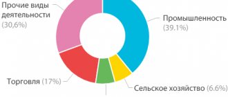
Economy and industry of the Novosibirsk region
The region's economy is based on the extraction of natural resources, engineering and food industries. The map of the Novosibirsk region allows you to examine in detail the location of industrial zones and deposits.
In the region, 7 oil and gas fields have been discovered and developed; marble, gold, coal, and peat are mined. Industrial enterprises of the region produce and produce:
- food products;
- beverages;
- tobacco products;
- electricity;
- electrical equipment and instruments;
- spare parts for cars;
- metal structures.
The mechanical engineering industry, which almost completely fell into decline during the “perestroika” period, is being actively restored. The largest ones and Sibselmash are establishing the production of agricultural machinery, aircraft instruments, turbines and steel-smelting furnaces.
The region has huge forest resources, you can see this on Yandex maps of the Novosibirsk region. Wood natural wealth is estimated at hundreds of millions of rubles.
Agriculture is most developed in the Barabinsk and Omsk regions, where livestock is raised for meat and milk is produced. In some areas, farms have also appeared that specialize in sheep breeding.
Novosibirsk is located in Western Siberia
This city is the largest in Siberia. The area of Novosibirsk is a little more than 500 square kilometers (this is five times smaller than Moscow).
Novosibirsk is located on both banks of the Ob (there is also the Novosibirsk Reservoir near the city). From Moscow to this city three thousand four hundred kilometers.
In general, Novosibirsk is a fairly large agglomeration that quickly covers the suburbs and nearby villages. At the same latitude as Novosibirsk are located: Moscow, Kaliningrad, Omsk, Chelyabinsk. This city has one and a half thousand streets and ten districts.
Parks, entertainment and more
Biotechnopark Koltsovo
Address: r/p Koltsovo, st. Tekhnoparkovaya, 1 Phone: 8 (3833) 06‑19-17, 8 (3833) 33‑37-03 Website: ick.ru Opening hours: Mon-Fri 9:00-18:00
An industrial park with an area of 114 hectares, the sites of which present the results of research and production in biotechnology and related fields.
The decision to create it was made by the government of the Novosibirsk region in 2011, and since then the construction and development of this science city in the form of a giant glass caterpillar has been underway.
Inside the building there are office premises, chemical, analytical and microbiological laboratories, a children's technology park and conference rooms.
Interesting facts about Novosibirsk
Here are some interesting facts about this Siberian city:
- It is in this city that the longest street in the world (without turns) is located. This record is recorded in the Guinness Book of Records.
- This city has been awarded the status of “The Most Reading City in Asia”, and all because one of the largest libraries in our country is located here.
- There is a unique zoo in Novosibirsk. More than a hundred animals that live in this “animal kingdom” are listed in the Red Book.
- There is also a unique Museum of the Sun here.
City infrastructure
As I wrote earlier, Novosibirsk stands on both banks of the Ob. You can get from the left to the right bank by driving along one of two bridges. Naturally, during rush hour there are simply gigantic traffic jams.
Novosibirsk also has a metro, which has only thirteen stations.
There are also a lot of minibuses, buses, trolleybuses and trams in the city.
The road surface in Novosibirsk is in rather poor condition. Some roads can easily be called minefields.
The capital of Siberia has a lot of large shopping and entertainment centers, shops, and catering establishments.
Friends, you often ask, so we remind you!
Flights
— you can compare prices from all airlines and agencies here!
Hotels
— don’t forget to check prices from all booking sites! Don't overpay. It's here!
Rent a Car
— also an aggregation of prices from all rental companies, all in one place, let's go here!
The name of this city has always been heard. Novosibirsk, it seems, is also called the capital of Siberia . I, perhaps, even to this day would not have known where exactly Novosibirsk is located in Russia, but it turned out that my main buyer of Siberian larch is from there. We've known him for a long time.
Historical places
IL-86 museum airplane (Ob)
Coordinates: N 55°00'40.9″ E 82°39'07.8″ How to get there: from Novosibirsk by train or train 17 km to the Ob or Aeroflot stations; 50 minutes by minibus No. 312.
Since 2015, a decommissioned IL-86 airliner has been stationed at the Tolmachevo airfield, which you can look at from the outside and climb aboard.
The plane was released on November 17, 1988, belonged to Avia and Sibir.
In 2008, aircraft of this model stopped flying. This is the only model that was not scrapped, which it was decided to leave as a monument to Soviet aviation.
Iskitim marble quarry
Coordinates: N 54° 36.109′ E 83° 20.731′ How to get there: by regular bus 49 km from Novosibirsk to Iskitim in 40 minutes.
Abandoned Shipunovskoe marble deposit in the form of an amphitheater near the city of Iskitim.
The height of the steps is approximately 1 meter.
Historical and architectural open air museum
Coordinates: N 54°50′58″ E 83°10′38″ How to get there: by car from Novosibirsk 20 minutes 30 km to the Akademgorodok stop.
A collection of cultural and historical Siberian monuments 4.5 km from the Novosibirsk academic campus.
Archaeological finds, exhibits in the form of yurts, black baths, cage huts, museum storage facilities, production sites and workshops are presented here.
The museum was created according to the design of architects S. N. Balandinin and V. Pergaev in 1972.
Museum of World Funerary Culture
Address: Voskhod village, st. Voentorgovskaya, 4/16 Phone: 8 (3833) 63‑03-29 Website: musei-smerti.ru Opening hours: Mon-Sun 11:00-19:00
The museum is located in the Memory Park of the Novosibirsk Crematorium. It presents the funeral traditions of different peoples of the world.
The initiative to create this museum belongs to S. B. Yakushin, academician of the European Academy of Natural Sciences and vice-president of the Union of Funeral Organizations and Crematoria. He spent about $14 million to open the museum in 2012.
It contains tens of thousands of artifacts related to burial rituals: funeral costumes, engravings, gravestones, hearses and sculptures, photographs and medals. The museum also contains about six thousand documents related to the topic of death: obituaries, official examinations, leaflets and forms.
This is the only museum dedicated to thanatology in Russia.
Novosibirsk is not the most distant city in Russia
It turned out that Novosibirsk is not yet the most distant city in Russia . There are also Krasnoyarsk, Irkutsk and the whole Far East. But you shouldn’t even try to drive into Novosibirsk by car. It's good if you arrive in a week. You can't sit behind the wheel all day long. I considered the option of a train, but this transport could not get there much faster, and it is not cheap. There was nothing left but to get to Moscow with my friend and business partner, and then board a plane.
Where Novosibirsk is, the new capital of Russia should be located
Novosibirsk is the capital of the Novosibirsk region (on the map).
The city is located in the center of Russia , in Western Siberia, at the same latitude as Moscow. It is the administrative center of the Siberian Federal District and the third largest city in the country. There has long been an idea in society to move the capital of Russia somewhere to the east. Here are just some of the arguments in favor of Novosibirsk that you can remember:
- optimal geographical location , in the center, at the intersection of routes;
- this city is already a major scientific and cultural center ;
- the need to relieve Moscow;
- the opportunity to make the government more independent of business by moving it outside of Moscow;
- a new impetus for the development of Siberia and the entire East of the country.
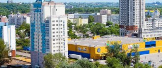
I was lucky to visit Novosibirsk in May of this year. Siberia turned out to be not cold, as I had always imagined. Located on the Ob , the city was all green. From the movement of the city and the new architecture, it was felt that the city and the entire region were developing. Having gone, I experienced for myself where Novosibirsk is located, and did not regret the trip.
Krasnoyarsk is a comprehensively developed metropolis
Krasnoyarsk was once called Bolshoi Ostrog. Even earlier, it became a center of attraction because it was located in a convenient place to live. It is believed that the first people settled on the territory of modern Krasnoyarsk closer to the Paleolithic era - approximately 35 thousand years ago.
The city's industry is represented by petrochemical and oil refining enterprises, there are factories for the production of non-ferrous metals, and there is a pharmaceutical plant that began producing penicillin more than 50 years ago. The educational sector also occupies a central position in the economy of Krasnoyarsk. The list of educational institutions is unusually large, including summer school, vocational schools that train technical specialists, polytechnic, pedagogical, assembly, construction colleges and technical schools. Krasnoyarsk is one of the scientific capitals with its own Academy Town. Local specialists study the problems of forest development, engage in computational modeling, biophysics and other areas. The culture of the metropolis is unusually rich. Many attractions are visited by tourists from different countries and regions of the Russian Federation. Dozens of sculptural compositions, museums, concert halls, theaters, libraries - Krasnoyarsk offers many options for cultural leisure.