Russia, Vologda region, Gryazovets district.
Link to the author’s article by Vologda historian Dmitry Aleksandrovich Pshenitsyn with research about the city of Gryazovec: https://www.bankgorodov.ru/place/Gryazovec
Location and directions
Gryazovets is a town on the Moscow road. This phrase is true. Before the construction of the Moscow-Vologda railway, the only route was the Moscow road, which crossed the center of Gryazovets and, taking into account the peculiarities of the construction of city blocks, suited the majority of city residents. Next to the road there was a hospital, a post office, a hotel (in the 60s of the 20th century it was called the “Collective Farmer’s House” (the author of the site is a witness to this) and other state and city (local) government bodies and authorities. Trade establishments were built along the road and fairs were located (shopping arcades). After the commissioning of the railway and the construction of the Gryazovets railway station, residents of the ancient city were able to easily get to the large shopping and industrial centers of the Russian Empire. The station is located on the outskirts of the city. A bus service was organized to the city center. In the summer of 2014 year, the author of the site, having arrived in his hometown (Gryazovets), was surprised to discover the absence of a regular bus route from the railway station to the city center, which means the indifference of the local authorities and “tears and snot” about the lack of funding, covering up his own reluctance to work and the desire to quickly “grab and get out" reached the northern lands of Russia. And when I analyzed the bus schedule at the Gryazovets bus station, I was completely shocked. It turns out that residents of the Gryazovets district do not need to visit the regional center but sit at home and rejoice at the meagerness, laziness and verbiage (dangerous) of the leaders who provide for the everyday life of the people. Why then did they try to steer, they would sit at home and “suck their paws.” Geographic coordinates Latitude: 58°52′33″N (58.875802) Longitude: 40°14′55″E (40.248495) Directions from Moscow Train from Yaroslavsky station 7 hours. 45 min., BlaBlaCar-6 hours. 20 minutes. Travel from St. Petersburg By plane to Vologda - 1 hour 30 minutes, then by bus 1 hour, BlaBlaCar - 9 hours. Distance: from Moscow: 434 km, from St. Petersburg: 717 km.
Short story
The first mention was in 1538. In 1780, the village of Gryazlevitsy was transformed into the district town of Gryazovets of the Vologda governorship. Description in the encyclopedic dictionary of Brockhaus and Efron (published at the border of the 19th-20th centuries) Gryazovets is a district town in the Vologda province, on the railway from Moscow to Vologda, 44 versts from the latter, on both banks of the Rzhavka River. The first information about the existence of a settlement on this site is found in a charter of 1538, granted to Kornilov to the Komel monastery, which mentions the Gryazovets repair, which belonged to the monastery. Subsequently, a trading village was formed here, in 1780 it was renamed a county town. In 1860 he lived. there were 2537, and in 1885 - 2301 (988 males and 1313 females). The buildings in 1873 were 449 wooden and 77 stone; churches - 3 stone; up to 200 shops. City bank, city school and women's gymnasium; city almshouse. City revenues in 1891 were 11,389 rubles, expenses were 10,976 rubles. All city property was valued in 1892 at 117,582 rubles. There were 4 factories and factories in 1891 with 34 workers and a total production amount of 42,594 rubles; one of these factories is a tannery, operating at 40,000 rubles; the other 3 are brick. Residents are mainly engaged in small crafts and trade; There are three fairs in the city every year. History of the name (toponym) In the 16th century. referred to as Pochinok Gryazovitsky. In the 17th century With. Gryazivitsy, also known as Gryazlivitsy, Gryazovitsy, Gryaznitsa, Gryaztsy. Since 1780 the city. Gryazovets. All forms of the name are from the base mud 'swamp, swamp'.
Gryazovets
(Vologda Region)
OKATO code:
19224501
Founded:
1538
City since:
1780 City of district subordination (Gryazovets district, Vologda region)
Center:
Gryazovets district
Telephone code (reference phone)
| 81755***** | 22-2-22 |
Deviation from Moscow time, hours:
0
Geographic latitude:
58°53′
Geographic longitude:
40°15′
Altitude above sea level, meters:
185 Sunrise and sunset times of the Sun and Moon in the city of Gryazovets
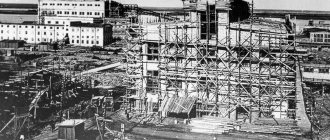
Old photos and images
City plan
Administrative and municipal status
Within the structure of administrative units, Gryazovets serves as the administrative center of Gryazovets District.[1] As an administrative division, it is part of the Gryazovets district as a city of regional significance of Gryazovets
.[2]
As a municipal entity, the city of district significance of Gryazovets, together with the village of Pirogovo in the Pertsevsky village council and the village of Svistunovo in the Rostilovsky village council of the Gryazovets district, is included in the Gryazovets municipal district as the Gryazovets settlement.
.[6]
Recommendations
Notes
- ^ a b c d f
Permit No. 178 - ^ a b c
Law No. 371-OZ - ^ a b c d
N. V. Soldatova (2006). G. V. Sudakov (ed.). Vologda Encyclopedia (PDF) (in Russian). Vologda: VSPU, Rus. p. 192. ISBN 5-87822-305-8. Received November twenty-first, 2013. - ^ a b
Federal State Statistics Service of Russia (2011).
“All-Russian Population Census 2010. Volume 1" [All-Russian Population Census 2010, vol. 1]. All-Russian Population Census 2010 [All-Russian Population Census 2010]
(in Russian). Federal State Statistics Service. - "26. The size of the permanent population of the Russian Federation by municipalities as of January 1, 2022.” Federal State Statistics Service. Retrieved January 23, 2022.
- ^ a b c d f
Law No. 1114-OD - "On the calculation of time." Official Internet portal of legal information
(in Russian). June 3, 2011. Retrieved January 19, 2022. - Post office. Information and computing center of OASU RPO. ( Post office
).
Search for postal facilities ( Search for postal facilities
) (in Russian) - Federal State Statistics Service of Russia (May 21, 2004). > [Population of Russia, its federal districts, federal subjects, districts, urban settlements, rural settlements - administrative centers, rural settlements with a population of more than 3000 people] (XLS). All-Russian Population Census of 2002 [All-Russian Population Census of 2002]
(in Russian). - “All-Union Population Census of 1989. The actual population of the union and autonomous republics, autonomous regions and districts, territories, regions, urban settlements and villages. Administrative-territorial division of the Arkhangelsk province in the 18th-20th centuries.” (in Russian). Archives of Russia. 2000. Archived from the original on July 24, 2011. Retrieved November 25, 2013.
- Public administration in the 18th–19th centuries (in Russian). Government of the Vologda region. Archived from the original on December 3, 2013. Retrieved November 25, 2013.
- ^ a b c d
Stages of historical development (in Russian). Administration of the Gryazovets Municipal District. Archived from the original on October 6, 2013. Retrieved November Twenty-first, 2013. - ^ a b
Information on changes in the administrative-territorial structure and network of party and Komsomol bodies of the Vologda region (1917–1991) (in Russian). Archives of Russia. Received November twenty-first, 2013. - Monuments of history and culture of the peoples of the Russian Federation (in Russian). Ministry of Culture of Russia. Retrieved June 2, 2016.
- Local History Museum of Gryazovets (in Russian). Russian Network of Cultural Heritage. Received November twenty-first, 2013.
Economy
Industry
Timber and food industry enterprises are located in Gryazovets.
Transport
One of the main highways of Russia, which connects Moscow and Arkhangelsk, passes near Gryazovets. There are also local roads, bus traffic comes from Gryazovets.
There is a railway station in Gryazovets on the connecting railway. Yaroslavl and Vologda.
Gryazovets has a gas pumping station. Here the Gryazovets – Vyborg Gas Pipeline branches off from the main Northern Lights Pipeline in a westerly direction.[13]
Veliky Ustyug is, in a broad sense, the “small” homeland of Father Frost
Veliky Ustyug is one of the oldest settlements in Russia, founded in 1141. Despite the modest number of Ustyug residents - 31,606, and area - 17 km, it is known to the residents of the country, being an important destination for winter family tourism. In addition to the residence of Father Frost, you can see 28 churches and temples built in the 17th and 18th centuries, which also attracts guests.
Tourism is an important source of income, since there are practically no industrial enterprises. From 2006 to 2010, the largest Russian fuel pellet production plant operated in Ustyug, which resumed operations in 2022. Folk crafts are developing, enterprises producing jewelry and traditional wooden products operate. The tourist flow could not radically change the situation: the town continues to remain sleepy, provincial, leading to a reduction in the number of Ustyun residents: since 1989 the level has decreased by almost 5,000.
Cherepovets is the largest in the Vologda region
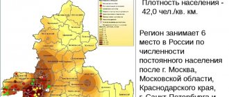
Cherepovets is the largest city in the Vologda region, where, according to information at the beginning of 2022, 318,856 people live. The area is small - 121 km², but for such a modest number of residents it is quite enough. The population density is 2,632.52 people/km. This value is typical for many small regional capitals. For comparison, in the capitals of neighboring entities it is:
- Yaroslavl - 2,957.83;
- Kostroma - 1,918.89;
- Petrozavodsk - 2,068.07.
It is an important industrial center, home to Russia's most famous mining and steel industries. Along with JSC Apatit, which operates in the chemical industry segment, it is one of the most significant enterprises: together the companies provide jobs for 40% of Cherepovets residents. In total, there are more than 1,500 enterprises, making the locality one of the ten largest industrial centers in the country. The level of industrial output per number of citizens is almost twice the national level. Thanks to the stable economy, the number of inhabitants does not stop growing: since 2008 it has increased by 10,000.
The capital Vologda is the second largest populated area
The capital of the region, Vologda, compared to the leader of the rating, is smaller in area and number of inhabitants with indicators of 116 km²/312,420 Vologda residents. However, in terms of density it is ahead of Cherepovets: the figure is impressive, amounting to 3,433.19. For comparison, in neighboring St. Petersburg the density is 3,837.47, in Arkhangelsk located to the north - 1,187.9.
Tourist attractiveness, high density, and relatively high standard of living lead to excessive motorization, traffic jams, and environmental deterioration. The level of air pollution is high: the main source of problems is exhaust gases. Industrial enterprises make a smaller negative contribution, but do not strive to modernize environmental safety systems.
The maximum period of growth of Vologda residents occurred in Soviet times, when the settlement grew from 60,000 to 280,000. After the collapse of the USSR, a demographic decline began, the traces of which can still be felt today: it is impossible to talk about stable growth, the increase occurs spasmodically.
Sokol is not small by the standards of the Vologda region
The third place on the list is occupied by the small town of Sokol with a population of 37,192. Sokol is developing thanks to industry: pulp and paper and woodworking.
Since 2010, the settlement has been included in the list of single-industry towns, and funds have been allocated for the development of Sokol’s traditional industry. However, government assistance did not produce the desired results: the number of residents, which has been steadily falling since 1996, continued its steady downward path. Over the past 20 years, the number of city residents has decreased by almost 10,000.
The most significant cities of the Vologda region by population
There are 15 cities in the Vologda region, among which there is not a single million-plus city. The largest settlements are the capital Vologda and industrial Cherepovets. Interesting: the latter is home to 6,436 more people than are registered in the capital. Next by a wide margin are Sokol and Ustyug, where the number of citizens is almost 10 times less than the largest settlements in the region. Sokol is included in the list of single-industry towns and is a woodworking center. The birthplace of the Slavic Santa, along with ancient Vologda, is attractive from a tourist point of view.
The Vologda region boasts the presence of 8 urban-type settlements. An interesting fact: in two of them - Sheksna and Kaduya, the number of residents even exceeds that of most cities in the region, amounting to 18,872 and 11,280, respectively. The list of the most populous includes:
- Cherepovets - 318,856.
- Vologda - 312 420.
- Sokol - 37,192.
- Veliky Ustyug - 31,606.
- Gryazovets - 14,916.
- Babaevo - 11,493.
- Vytegra - 10,232.
- Totma - 9,895.
- Kharovsk - 9,185.
- Belozersk - 8,914.
Due to such a large population gap between the two leading and small settlements, the social portrait of the region is extremely ambiguous. On the one hand, the indicators of poverty and unemployment are lower than the Russian average. In fact, the statements described above are typical only for Cherepovets, Vologda and their suburbs. On the periphery, in small villages and towns, the situation is the opposite: lack of work, social degradation.