For other places with the same name, see Sim, Russia.
City in Chelyabinsk region, Russia
| Sim Sim | |
| City [1] | |
| Coat of arms | |
| Sim Location | |
| Sim Sim Location Show map of Russia Sim Sim (Chelyabinsk region) Show map of Chelyabinsk region | |
| Coordinates: 54°59'N 57°42'E / 54.983°N W. 57.700 ° E. / 54.983; 57.700 Coordinates: 54°59'N 57°42'E. / 54.983 ° N W. 57.700 ° E. / 54.983; 57,700 | |
| A country | Russia |
| Federal subject | Chelyabinsk region [1] |
| Administrative region | Ashinsky district [1] |
| Town | Sim [1] |
| Based | 1759 |
| City status from | November 13, 1942 |
| Height | 200 m (700 ft) |
| population size (2010 Census) [2] | |
| • General | 14 466 |
| • Evaluate (2018) [3] | 12 893 ( -10,9% ) |
| Administrative status | |
| • Capital from | City Sim [1] |
| Municipal status | |
| • Municipal district | Ashinsky municipal district [1] |
| • Urban village | Simskoe urban settlement [1] |
| • Capital from | Simskoe urban settlement [4] |
| Timezone | UTC+5 (MSK+2[5]) |
| Postal code [6] | 456020, 456021 |
| OKTMO ID | 75609105001 |
| Web site | www.gorodsim.ru |
Sim
(Russian: Sim) is a city in the Ashinsky District of Chelyabinsk Oblast, Russia, located on the Sim River, 340 km (210 mi) west of Chelyabinsk, the administrative center of the region. Population: 14,466 people (according to the 2010 census); [2] 16,377 (2002 census); [7] 20,164 (1989 census). [8]
Links[edit]
Notes[edit]
- ^ abcdefghi Resolution No. 161
- ^ a b Federal State Statistics Service (2011). “All-Russian Population Census 2010. Volume 1" [All-Russian Population Census 2010, vol. 1]. All-Russian Population Census 2010 [All-Russian Population Census 2010]
. Federal State Statistics Service. - "26. The size of the permanent population of the Russian Federation by municipalities as of January 1, 2022". Federal State Statistics Service. Retrieved January 23, 2022.
- Federal State Statistics Service. Federal Agency for Technological Regulation and Metrology. No. OK 033-2013 January 1, 2014 “All-Russian classifier of municipal territories. Code 75 609 105 ". (Federal State Statistics Service. Federal Agency for Technological Regulation and Metrology. No. OK 033-2013 dated January 1, 2014. Russian Classification of Municipal Territories. Code 75 609 105.
). - "On the Calculation of Time". Official Internet portal of legal information
. June 3, 2011. Retrieved January 19, 2022. - Post office. Information and computing center of OASU RPO. ( Post office
).
Search for postal service objects ( postal Search for objects
) (in Russian) - ↑
Federal State Statistics Service of Russia (May 21, 2004).
“The population of Russia, the constituent entities of the Russian Federation as part of federal districts, urban settlements, settlements, settlements of 3 thousand or more people” [Population of Russia, its federal districts, federal districts, districts, urban settlements, rural settlements - administrative centers and rural settlements with a population of more than 3,000 people] (XLS). All-Russian Population Census 2002
. - “All-Union Population Census of 1989. The current population of union and autonomous republics, autonomous regions and districts, territories, effects, urban settlements and rural district centers” [All-Union Population Census of 1989: current population of union and autonomous republics, Autonomous regions and districts, territories, regions, districts, urban settlements and villages performing the functions of district administrative centers. All-Union Population Census of 1989 [All-Union Population Census of 1989]
.
Institute of Demography of the National Research University: Higher School of Economics [Institute of Demography of the National Research University: Higher School of Economics]. 1989 - via Demoscope Weekly
.
Introductory section “Tourism in the Urals” (cities, natural sites, attractions, museums, architectural complexes). City Sim. Chelyabinsk region. Distance from Chelyabinsk – 290 kilometers (along the M5 highway).
Location of the city on Yandex maps.
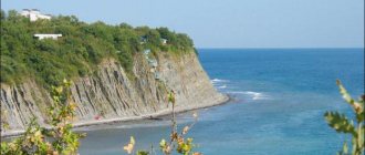
The Simskoe urban settlement is located in a picturesque place in the Southern Urals at the confluence of two rivers - Sim and Kuryak in a large floodplain valley surrounded by mountains and forest. Geographically, Sim belongs to the Ashinsky district. The name comes from the ancient Bashkir word -SYUM-, which means “love”, “beloved”.
More than two and a half centuries ago, these majestic wild places, owned by the Bashkir tribes, attracted the attention of factory owners who were building a factory empire in the Southern Urals. By decree of Her Imperial Majesty Elizaveta Petrovna dated March 29, 1759, permission was given to the Siberian merchant Matvey Myasnikov to build an ironworks on the Sim River. The population of the factory village was formed from serf peasants of Tula, Moscow, Ryazan, Kaluga and other provinces of Russia. There were a total of 1880 souls. Now the population of Simsk is about 15.3 thousand. This is one of the oldest centers of metallurgy in the Southern Urals. During the Peasant War under the leadership of E.I. Pugachev (1773-75), the plant was destroyed and rebuilt in 1778.
The city's main enterprise, the machine-building enterprise, produced units for the needs of civil and military aviation and the rocket and space industry during the Soviet period. Today the main products are pumps for Volga cars, rescue tools, units for lifting mechanisms, and pumps. Units for the aviation industry are produced in small volumes.
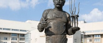
The city is also rich in its outstanding people: academician three times Hero of Socialist Labor I.V. was born here. Kurchatov, heroes of the Civil and Great Patriotic Wars V.D. Kovshov, M.V. Guzakov, former directors of the plant Puzikov G.M., holder of two Orders of Lenin, the Order of the Red Banner of Labor, the Order of the October Revolution, Davydov V.F., Chairman of the Legislative Assembly of the Chelyabinsk Region, awarded the Order of Honor, Honored Workers of Culture of the Russian Federation Gabaidullin Kh. .Kh., Ogorodov A.A., Honored Artist of Russia Borodina L.V., Honored Doctor of the Russian Federation Revin V.A.
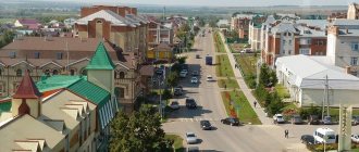
“A lot has been written about Sim, especially about Simsky Pond. Sim is known to everyone who has ever driven along the Ufa-Chelyabinsk highway. An amazing panorama opens up before those passing by - in a lowland surrounded by mountains, the city is spread out in full view. Exactly in the center, a two-hundred-meter thermal power plant pipe rises like a beacon, and a ribbon of river winds through the entire city!
Like any technical pond created to ensure the operation of the old Ural ironworks, the pond was created along with the plant in 1759 as a result of the construction of a dam on the Sim River. The surface of the water, like a horseshoe, is surrounded by rocks covered with forest, and in the center of the pond rises a picturesque mountain - Zhukova Shishka. It was named after the priest Zhukov, who once held services here. Some call this mountain "Devil's Finger". Indeed, if you look at the mountain from the side of the dam, the rocky outcrops are very similar to a palm with a protruding little finger. There was even a legend about a devil who tried to crawl out of the underworld, but could not; only his hand remained on the surface, petrified. It’s great to sit on the top “finger” and admire the surroundings. From here the whole city is at your fingertips.
But this mountain is unique not only for its appearance. Relict spruces and firs grow on it, and mighty pines grow on rock formations. Of the 22 endemic and relict plants in the Chelyabinsk region, two species are found only here - double-veined thyme and bedstraw. Thyme is generally a Pliocene-Pleistocene rock and mountain-steppe endemic of the Southern Urals. In the Chelyabinsk region it was found only here, on Mount Zhukova Shishka.
These places are generally loved by tourists - “specialists”: they go kayaking in deep water, and they give rock climbers training. Speleologists also have something to do: in the vicinity of the pond there are several small caves, and according to geologists, there are about a dozen of them upstream of the river!
It's a pleasure to swim in the pond. The river in Sima is shallow, “up to a chicken’s knee.” On the shore of the pond there was a ten-meter diving tower. The history of its design is interesting: November 1973. After another business trip to Moscow, the plant director invited the chief mechanic to his office. “We will have a recreation area on the reconstructed pond, where we plan to build a city beach. There should be a diving tower on the beach, but not just any tower, but an exact copy of the one located in the Moskva swimming pool in Moscow. Your design bureau is tasked with constructing an exact copy of the tower. Here is the Ogonyok magazine, there is a photograph of the tower. The design development period is two weeks. Get started." No one dared to contradict the domineering director. And the chief mechanic went, with his head down, to his department. How can you complete a task with only a journal? But in our country of Lefties and Kulibins, this may not be the case. Having calculated the scale of the tower from the magazine, the designers began work. And already in the summer of 1974 in Sima, those who wished could demonstrate their skills in jumping from a ten-meter tower, not suspecting that they were jumping from almost “the most important tower in the country.” Now all that remains of that tower are horns and legs - only a concrete base and the memories of local residents. And the “main tower of the country” is no longer in Moscow; in its place stands the restored Cathedral of Christ the Savior.” – from an article by guide Olga Shokhina.
What to see in the city of Sim? 10 sights of the city.
1. Simskoye Reservoir (Simsky Pond) is an artificial reservoir. It has been a hydrological natural monument since 1987. The reservoir is located on the river. Sim, near the southern outskirts of the city, in the upper section of the river. Built in 1972 for the purpose of water supply. The Simskoye Reservoir is one of the most beautiful artificial reservoirs in the Chelyabinsk region. It is surrounded by rocks covered with forest. There are many picturesque capes, cliffs and oddly shaped outcrops. The Zhukova Shishka mountain is adjacent to the dam. The hydraulic structures include: earthen embankment dam; controlled surface spillway (on the left bank) made of monolithic reinforced concrete; bull-type water intake (in the left abutment of the spillway). The reservoir is a favorite vacation spot for city residents. Since 1976, the Snow Carousel ski festival has been held here annually in winter, attracting more than 2 thousand participants from many cities in the Chelyabinsk region and Russia.
2. Mount Zhukova Shishka is located on the northwestern outskirts of the city of Sim and is a specially protected natural site. The height is about 300 meters. Back in 1770 - 1771, Peter Simon Pallas mentioned a conical mountain near Simskoe. This rocky hill organically merges with the dam of the Simskoe reservoir. It is composed of light limestones. There is a small cave in one of its steep slopes. On the Zhukovaya Shishka, relict spruce and fir trees grow, on the rock formations - powerful pines, and also rare plants grow: furrow carp, dark red napkin, Krasheninnikov's minuartia, foxglove grandiflora, European undergrowth, bedstraw, etc. At the foot of the mountain a monument to Glory was erected in memory of the residents of Sima who died in the Great Patriotic War.
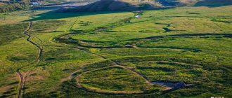
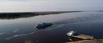
3. The Sim River is a tributary of the Belaya River and is known for its numerous and picturesque rocks, caves, and grottoes. Geographically located within the Chelyabinsk region and Bashkortostan. Length 239 kilometers. The source of the river is on the northern slopes of the Amshar ridge. Settlements located in the vicinity of the river: Sim, Minyar, Asha, Ulu-Telyak, Kazayak-Kutush, Petrovskoye, Kuznetsovka, Serpievka. The tributaries of the Sim River are Inzer, Minyar, Asha, Lemeza, Uk, etc. The most famous caves are Serpievsky Cave City and Ignatievskaya Cave. And in the area of the Ignatievskaya Cave, the river flows along an underground channel, forming a dry valley. Not far from the mouth of the river is the Okhlebininskaya cave. The Sim River basin can be divided into two parts: mountainous and flat. In the upper reaches from the city of Sim to the city of Asha, the river flows among mountain ranges located on both sides and covered with mixed forest. The Adzhigardak ridge stretches along the left bank, and the Sparrow Mountains along the right bank. In the city of Asha, the landscape changes, the riverbed turns southwest, leaving the mountain ranges. Downstream along the banks there is a forest with dense undergrowth, small swamps and oxbow lakes. In the area of the village of Kazayak-Khusnullino there are low mountains. In the upper reaches of the city of Sim, a dam was built on the river, forming a pond.
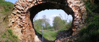
4. The city has preserved the remains of a dam , which was built by the dam master A. Isaev to ensure the operation of the Simsk ironworks in 1759. This hydraulic structure was described by academician P.S. Pallas, who visited the Simsky plant in May 1770: “The dam at the plant is no longer than one hundred fathoms, at the base it is reinforced across the laid beams, and therefore it seems that it can be strong.” Durable, for sure: it stood right up to the middle of the twentieth century.
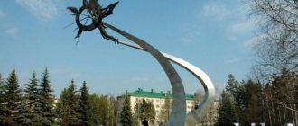
5. The city of Sim is the birthplace of Igor Vasilyevich Kurchatov . Soviet physicist, “father” of the Soviet atomic bomb. Three times Hero of Socialist Labor. Academician of the USSR Academy of Sciences and the Uzbek SSR Academy of Sciences, Doctor of Physical and Mathematical Sciences, Professor. Founder and first director of the Institute of Atomic Energy. Chief scientific director of the atomic problem in the USSR, one of the founders of the use of nuclear energy for peaceful purposes. Winner of the Lenin Prize and four Stalin Prizes. Honorary citizen of the USSR. On November 25, 1977, a monument was unveiled in the scientist’s homeland in the city of Sima - at the central entrance of the plant (design by sculptor A. D. Shcherbakov and architect G. A. Zakharov). The bronze bust is distinguished by its laconicism and simplicity of form: the details of clothing are minimally indicated and there are no awards. The monument is installed on a rectangular pedestal made of dark granite with bluish veins, almost identical in width to it. The total height of the monument is 4 meters. In the city there is a room-museum of Igor Vasilyevich Kurchatov.
6.
7. Historical and Revolutionary Museum of the City of Sim
8. Serpievsky Cave Castle
9. Monument to Komsomol members of the 1960s
10. Church in the name of St. Demetrius of Thessalonica
Sources – Encyclopedia of the Chelyabinsk Region , Administration of the Simsky urban settlement, Wikipedia, articles by the guide – Olga Shokhina.
Notes
- [agarh.permkrai.ru/af/index.php?act=fund&fund=21355 Solikamsk District Executive Committee of Workers' Deputies 1924-1978 Solikamsk District Committee of People's Deputies 1979-1991 - Fund No. P-1 - Archival Department Solikam...]. Retrieved January 17, 2013. [www.webcitation.org/6E1MmUuvm Archived from the original on January 29, 2013].
- [crims.ru/info/in_prison/privolzhskij_federalnyj_okrug Volga Federal District | Prisons of the Russian Federation]. Retrieved January 17, 2013. [www.webcitation.org/6E1MoUnVM Archived from the original on January 29, 2013].
- [ruosolkam.narod.ru/p20aa1.html District schools]. Retrieved January 17, 2013. [www.webcitation.org/6E1Mpf709 Archived from the original on January 29, 2013].