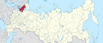
The Samara region territorially belongs to the Volga region, the Volga River flows along it. Using a satellite map of the Samara region, you can see that this region has common borders with Kazakhstan, Tatarstan, the Orenburg region, as well as the Ulyanovsk and Saratov regions.
Various mineral resources are mined within the area. The highest mountain is called the Observer.
There are many industrial enterprises in the region, which are clearly demonstrated by the map of the Samara region.
Municipal structure
Within the framework of the municipal structure, within the boundaries of the administrative-territorial units of the region, the region includes, respectively, the following upper-level municipalities:
- 10 urban districts
- 27 municipal districts.
Their boundaries are approved in the form of a cartographic description by 37 laws of the Samara region.
Within the municipal districts, the boundaries of lower-level municipalities have been established in the number of 296 settlements, including 12 urban and 284 rural settlements as of January 1, 2022.
The new edition of the Charter of the Samara Region provides for the formation of municipal districts.
The spread of coronavirus in Russian regions as of January 13, 2022
| Region | Revealed | New | Recovered | Died |
| Moscow | 2069957 | 5490 | 1899550 | 37670 |
| Saint Petersburg | 870526 | 1839 | 816693 | 28811 |
| Moscow region | 655865 | 1556 | 604953 | 12640 |
| Nizhny Novgorod Region | 234531 | 647 | 221151 | 10133 |
| Sverdlovsk region | 203902 | 410 | 178059 | 9686 |
| Samara Region | 202955 | 225 | 171391 | 6477 |
| Rostov region | 198232 | 391 | 180098 | 9853 |
| Voronezh region | 196845 | 242 | 168479 | 7115 |
| Krasnoyarsk region | 176557 | 265 | 161615 | 9024 |
| Perm region | 164517 | 309 | 151841 | 7618 |
| Irkutsk region | 160613 | 254 | 148269 | 7127 |
| Chelyabinsk region | 149721 | 232 | 141524 | 6355 |
| Saratov region | 135578 | 172 | 125049 | 5191 |
| Omsk region | 133375 | 215 | 125343 | 3310 |
| Volgograd region | 131785 | 172 | 122443 | 5740 |
| Stavropol region | 128640 | 352 | 109157 | 6260 |
| Khabarovsk region | 128434 | 229 | 119868 | 1283 |
| Republic of Crimea | 127909 | 94 | 119302 | 4548 |
| Arhangelsk region | 125511 | 154 | 115530 | 1549 |
| Republic of Bashkortostan | 124648 | 198 | 115538 | 4546 |
| Krasnodar region | 123690 | 353 | 102873 | 9918 |
| Altai region | 123467 | 289 | 106113 | 6902 |
| Ulyanovsk region | 121754 | 95 | 115413 | 3914 |
| Orenburg region | 109167 | 86 | 98918 | 3527 |
| Primorsky Krai | 105727 | 251 | 89213 | 1611 |
| Leningrad region | 104830 | 243 | 94790 | 3066 |
| Penza region | 104132 | 160 | 91806 | 4750 |
| Tver region | 101251 | 280 | 90842 | 2417 |
| Vologda Region | 101052 | 122 | 93143 | 3066 |
| Bryansk region | 98637 | 144 | 94306 | 3044 |
| Komi Republic | 98604 | 91 | 85211 | 2690 |
| Novosibirsk region | 98154 | 251 | 68779 | 4396 |
| Khanty-Mansi Autonomous Okrug | 97547 | 164 | 92449 | 2075 |
| Transbaikal region | 97249 | 103 | 87883 | 1941 |
| Murmansk region | 93151 | 122 | 76265 | 2831 |
| Tyumen region | 92619 | 198 | 83084 | 3559 |
| Republic of Karelia | 91577 | 152 | 87449 | 1244 |
| Kemerovo region | 88380 | 198 | 80594 | 1771 |
| Yaroslavl region | 88155 | 189 | 80734 | 2005 |
| Smolensk region | 86085 | 141 | 79047 | 2453 |
| Lipetsk region | 85521 | 123 | 79343 | 2907 |
| Kaliningrad region | 84096 | 168 | 80968 | 1315 |
| Vladimir region | 83514 | 138 | 75393 | 2986 |
| Belgorod region | 83044 | 107 | 75447 | 1821 |
| Astrakhan region | 82890 | 136 | 78639 | 2520 |
| Kursk region | 82882 | 89 | 78378 | 2101 |
| Kirov region | 81214 | 178 | 71338 | 779 |
| Udmurt republic | 79772 | 59 | 70082 | 3270 |
| The Republic of Buryatia | 77914 | 121 | 73079 | 2512 |
| Tula region | 77817 | 202 | 68824 | 4402 |
| The Republic of Sakha (Yakutia) | 77206 | 147 | 73762 | 1821 |
| Pskov region | 72408 | 86 | 68734 | 1334 |
| Oryol Region | 71850 | 147 | 67354 | 1568 |
| Ivanovo region | 69587 | 113 | 62404 | 2613 |
| The Republic of Dagestan | 67267 | 158 | 61526 | 3264 |
| Novgorod region | 66711 | 89 | 63345 | 805 |
| Kaluga region | 66700 | 136 | 62537 | 1255 |
| Tomsk region | 63429 | 110 | 54696 | 685 |
| Tambov Region | 63357 | 168 | 58328 | 1804 |
| Ryazan Oblast | 62626 | 74 | 58154 | 2661 |
| Yamalo-Nenets Autonomous Okrug | 62551 | 64 | 58491 | 968 |
| Amur region | 56444 | 172 | 49812 | 622 |
| The Republic of Khakassia | 54464 | 81 | 51652 | 2056 |
| Sevastopol | 53526 | 89 | 50800 | 1891 |
| Kurgan region | 51806 | 81 | 49397 | 1031 |
| Kostroma region | 49061 | 38 | 47526 | 1141 |
| Chuvash Republic | 47159 | 54 | 41043 | 4115 |
| Republic of Tatarstan | 43958 | 107 | 37355 | 1506 |
| Sakhalin region | 43456 | 203 | 41489 | 577 |
| Kabardino-Balkarian Republic | 43089 | 82 | 39101 | 1508 |
| The Republic of Mordovia | 41139 | 58 | 36674 | 1075 |
| Republic of Kalmykia | 34176 | 15 | 32674 | 748 |
| Karachay-Cherkess Republic | 32989 | 55 | 29351 | 919 |
| Republic of North Ossetia-Alania | 31859 | 68 | 29359 | 1014 |
| Tyva Republic | 31701 | 15 | 30728 | 322 |
| Chechen Republic | 31558 | 60 | 29747 | 962 |
| Mari El Republic | 29846 | 34 | 28168 | 956 |
| The Republic of Ingushetia | 29527 | 70 | 27636 | 489 |
| Republic of Adygea | 28098 | 60 | 23385 | 772 |
| Altai Republic | 25584 | 17 | 23408 | 533 |
| Kamchatka Krai | 24045 | 58 | 19090 | 515 |
| Magadan Region | 13779 | 15 | 13225 | 356 |
| Jewish Autonomous Region | 11842 | 20 | 10939 | 430 |
| Nenets Autonomous Okrug | 3538 | 8 | 3394 | 88 |
| Chukotka Autonomous Okrug | 2976 | 4 | 2808 | 39 |
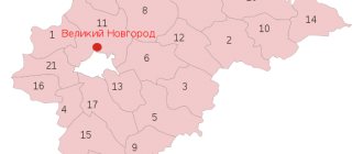
Settlements
Alekseevsky district
Bezenchuksky district
Bogatovsky district
Bolsheglushitsky district
Bolshechernigovsky district
Borsky district
Volzhsky district
Elkhovsky district
Isaklinsky district
Kamyshlinsky district
Kinelsky district
Kinel-Cherkasy district
Klyavlinsky district
Koshkinsky district
Krasnoarmeysky district
Krasnoyarsk district
Neftegorsky district
Pestravsky district
Pokhvistnevsky district
Privolzhsky district
Sergievsky district
Stavropol district
Syzran district
Khvorostyansky district
Chelno-Vershinsky district
Shentala district
Shigonsky district
Districts of the Samara region
In the transport sector, the pipeline mode of transport is the leader in terms of cargo turnover. The leader in passenger flow is road transport.
Federal highways pass through the region. These are roads E 30, M 5, E 121, P 228.
The region is crossed by the most important railway lines. The Samara region is also connected by waterways with other regions. The length of shipping routes is about 680 km. There are three river ports in the region. Transportation is also carried out by air.
All airports will be shown in detail on a map of the Samara region. The map is a real assistant on any trip; it allows you to find all the objects of the region, including the main areas of the region.
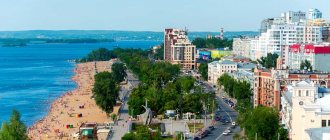
Samara is considered the administrative city of the Volzhsky region. The area is surrounded by magnificent natural scenery.
The area is considered an important agricultural producer. On its territory there are many agricultural enterprises and processing organizations, which a map of the Samara region by district will help you find.
The Kinelsky district is located in the center of the region. There are more than 20 agricultural organizations in the district. There is also a soda factory and a brewery. A highway of federal and republican significance stretches through the area.
More than 400 enterprises can be found in the Neftegorsk region. There are also 4 collective farms and more than 90 farms on its territory.
Among the developed areas on the map of the Samara region, the Pokhvistnevsky district stands out, where the agricultural sector is developed, and gas and oil are also actively extracted. The Severny Klyuch enterprise supplies a third of the pork in the region. The area has an extensive road network. There is a highway of republican significance, and the territory is also crossed by the Trans-Siberian railway line.
Tolyatti is considered the administrative city of the Stavropol region. This area has recreational conditions for the development of tourism and health resort business. On its territory are the Zhiguli Mountains. More than 2,700 different enterprises are registered in the area.
The best areas of Samara to live in 2022
October
We give first place to the Oktyabrsky district.
This is the business center of the city, as well as the area with the largest number of new buildings within the city. It starts in the very center and includes multi-storey buildings on clearings near the Volga - and these are houses with views of the river and magical sunsets. The district is home to the largest universities (Samara University, PSUTI), the Botanical Garden, and the largest Country Park in the city. What is convenient for living?
This area has the best transport accessibility. Its northern part, which is closer to the Volga, is equipped with a dedicated tram line, while the southern part has access to several metro stations. Also, it is within the district that the two largest transport arteries of the city are located - Moskovskoe Highway and Novo-Sadovaya.
The area is located practically in the geographical center of the city and is equally remote from both the historical part of Samara and the residential areas on the outskirts.
What contingent
One of the most diverse areas in terms of population. In areas with old buildings, representatives of the creative intelligentsia and people with low social responsibility may coexist, those who have been living in old houses for more than one generation and cannot afford to move to more comfortable housing. In newer areas there are many young families, including state employees, employees of rocket manufacturing enterprises, university teachers and middle managers.
How noisy
Very uneven. Houses near major highways, of course, do not provide adequate privacy. But those hidden in cozy courtyards are suitable for those who love silence.
Is it suitable for children
In areas with dense buildings, many families with children live; there are playgrounds and houses with comfortable apartment layouts. But there are not enough schools and kindergartens, this needs to be taken into account..
Features of the housing stock
Oktyabrsky ended up in the top areas for living because it is here that the largest amount of high-quality new housing is concentrated. The most popular among buyers are high-rise buildings near Postnikov Ravine.
It is worth noting that in this area there are quite a lot of private houses with high-quality infrastructure - we are also talking about those located on Proseki or in the area of Novo-Sadovaya Street, in the so-called Garden City. Here you can enjoy all the benefits of civilization, live close to transport, and at the same time feel like you are in a cottage village. The downside is a certain number of neighbors from disadvantaged backgrounds.
Residential areas on Proseki near the Volga are also characterized by an insufficient number of parking lots. Another disadvantage is that to get to public transport, residents have to overcome a rather steep climb up to the main highway.
Prices
| One-room apartment in a new building | From 2.7 million rubles. |
| One-room apartment in a secondary building | From 1.5 million rubles. |
| Two-room apartment in a new building | From 3.8 million rubles. |
| Two-room apartment in a secondary building | From 2 million rubles. |
| Three-room apartment in a new building | From 4.5 million rubles. |
| Three-room apartment in a secondary building | From 2.8 million rubles. |
| Average price per m2 | From 75,000 rub. |
Economy and industry of the Samara region
Yandex maps of the Samara region will help you find more than 4 thousand enterprises in the region. Most of the companies are engaged in the engineering, chemical and fuel industries. The largest production of passenger cars in the country is AvtoVAZ, which is located in Togliatti. The following large companies can be noted:
- Samarneftegaz;
- Oil refining;
- "Togliatti-Azot".
The region produces a large amount of petroleum products: gasoline, fuel oil. Agriculture is developing intensively. Crop production includes barley, wheat, vegetables and sunflowers.
The region also has developed meat and dairy production, poultry farming and pig farming. A map of the Samara region with villages will allow you to find all retail organizations. The Samara region has a low unemployment rate. The region is famous for its manufacturing industries. In some cities, tourism is actively developing.
Map of the Samara region with cities and villages
All major settlements in the region can be found on a map of the Samara region with cities and villages:
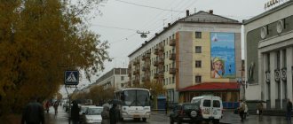
- More than a million people live in Samara. The city has a metro and modern railway stations. Samara has many cultural institutions and large enterprises. The largest enterprise for the production of reinforced concrete products is located here. The city is also considered the center of the engineering industry in the region. There are more than 30 markets and more than 60 large shopping centers on the territory. All shopping facilities are displayed on a map of the Samara region with settlements.
- The city of Togliatti is considered a real industrial center. At the same time, huge production capacities have a negative impact on the environment.
- Syzran is a small town. There are several large enterprises located within the city. One of them is an oil refinery, which a detailed road map of the Samara region will help you find.
- The population of Novokuibyshevsk is more than 100 thousand people. There are a large number of enterprises in the city. These are petrochemical organizations, construction companies and food industry enterprises.