Sovetsk
(Kirov region)
OKATO code:
33236501
Founded:
1594
City since:
1937 City of district subordination (Sovetsky district, Kirov region)
Center:
Sovetsky district
The city was formerly called:
| crow | 1594 | 1918 |
| Telephone code (reference phone) | |
| 83375***** | 12-2-22 |
Deviation from Moscow time, hours:
0
Geographic latitude:
57°35′
Geographic longitude:
48°57′
Altitude above sea level, meters:
100 Sunrise and sunset times in the city of Sovetsk
Kirov region: general information
The Kirov region is part of the Volga Federal District. Territorial possessions amount to 120,374 km².
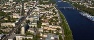
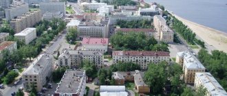
The heart of the region, that is, its capital, is the city of Kirov. In addition to it, the region includes 17 more cities, the population of which varies from 6 to tens of thousands of people. Kirov as the capital has the largest number of inhabitants from the main population of the region.
Kirovo-Chepetsk is the second largest city in the region by population. Its population is 73,000 people.
Map
| Sovetsk: maps |
Sovetsk: photo from space (Google Maps) Sovetsk: photo from space (Microsoft Virtual Earth)
| Soviet Nearest cities. Distances in km. on the map (in brackets along roads) + direction. Using the hyperlink in the distance , you can get the route (information courtesy of the AutoTransInfo website) | |||
| 1 | Pizhanka | 28 (34) | SW |
| 2 | Lebyazhye | 40 (38) | SE |
| 3 | Arbazh | 40 (80) | Z |
| 4 | Verkhoshizhemye | 47 (52) | WITH |
| 5 | Nolinsk | 58 (114) | IN |
| 6 | Pushing | 59 (99) | Z |
| 7 | New Toryal (Republic of Mari El) | 66 (74) | YU |
| 8 | Yaransk | 71 (78) | SW |
| 9 | Suna | 71 (90) | IN |
| 10 | Sernur (Republic of Mari El) | 73 (100) | YU |
| 11 | Kumeny | 81 (179) | NE |
| 12 | Urzhum | 81 (88) | SE |
| 13 | Kuzhener (Republic of Mari El) | 85 (107) | YU |
| 14 | Kotelnich | 87 (101) | NW |
| 15 | Orichi | 91 (104) | WITH |
| 16 | No | 91 (144) | IN |
| 17 | Soviet (Republic of Mari El) | 96 (115) | YU |
| 18 | Mari-Turek (Republic of Mari El) | 96 (137) | SE |
| 19 | Orshanka (Republic of Mari El) | 97 (129) | SW |
| 20 | Paranga (Republic of Mari El) | 101 (134) | YU |
| 21 | Orlov | 105 (148) | WITH |
| 22 | Kiknur | 108 (120) | Z |
| 23 | Bogorodskoye | 110 (153) | IN |
| 24 | Candle | 114 (141) | NW |
| 25 | Tonshaevo (Nizhny Novgorod region) | 116 (205) | Z |
| 26 | Semyonovka (Republic of Mari El) | 119 () | SW |
| 27 | Kirov | 120 (129) | WITH |
a brief description of
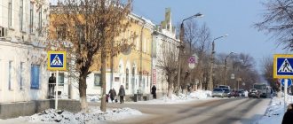
Located on the high right bank of the river. Pizhma, 4 km from its confluence with Vyatka, where the pier is located, 103 km south of the railway. Kotelnich junction, 140 km south of Kirov.
Territory (sq. km): 26
Information about the city of Sovetsk on the Russian Wikipedia site
Historical sketch
Founded in 1594 (according to other sources, around 1609) on the lands of the Mari-Cheremis as the settlement of Kukarka. The settlement consisted of several courtyards around a wooden church, surrounded by a high palisade and a deep ditch. The main occupation of the residents was agriculture and the supply of grain to Western Siberia. In 1620, the settlement had 63 courtyards, a church, 2 forges, 2 water mills.
In the 18th century Academician G.F. Miller associated the oikonym with the Udmurt kar “city”; in the 20th century it has been suggested that it is connected with slash-and-burn agriculture: the Turkic-Bulgar kukar “burnt out place, burning place.”
In the 18th-19th centuries. Kukarka is a large craft and trade center in the Vyatka province. Carpentry, the manufacture of carts and sleighs, were developed, and flask stone was mined, from which grinding stones, wheels, and millstones were made. Sloboda was famous for lace making (a school of lace makers since 1893), fulling and pottery production.
In 1870, there were 5 churches in the settlement, and there were 65 stone and 75 wooden shops. A power station was built in 1910, and a telephone appeared in 1911.
In 1918, by decision of the Vyatka Provincial Executive Committee, the Kukarka settlement was renamed the city of Sovetsk. However, in 1931 it was listed as the village of Sovetsk. City of Sovetsk since 1937
Economy
Meat processing plant, butter factory, food processing plant. Factories: for the production of felted shoes, a glove factory, a branch of the Kirov factory of stitching and lace products. Woodworking plant. Elevator.
In the vicinity of Sovetsk there is mining of crushed stone.
In the Sovetsky region, rye, wheat, barley, oats, potatoes, and vegetables are grown. They raise cattle, pigs, and sheep. Poultry farming.
Deposits of rubble stone, crushed stone, limestone, sand, gravel, marl, peat.
Culture, science, education
Museum of Local Lore.
Museums, galleries, exhibition halls
Sovetsky District Museum of Local Lore 613340, Kirov region, Sovetsky district, Sovetsk, sq. Malkova, 6 Phone(s): (83375) 2-2497
Architecture, sights
Church of the Intercession (early 17th century), Lebedeva's house (19th century).
Until the 1970s wooden manor-type houses predominated in the city.
In 1990, a bridge was built across the Vyatka River.
In the Sovetsky region there are caves: Zaramenskaya, Paradnaya, Kholodnaya, Sofronovskaya and others.
| Population by year (thousands of inhabitants) | |||||||
| 1939 | 10.8 | 1996 | 18.8 | 2007 | 16.5 | 2015 | 15.7 |
| 1959 | 14.6 | 1998 | 18.9 | 2008 | 16.2 | 2016 | 15.7 |
| 1967 | 17 | 2000 | 18.7 | 2010 | 15.8 | 2017 | 15.6 |
| 1970 | 17.0 | 2001 | 18.4 | 2011 | 16.6 | 2018 | 15.5 |
| 1979 | 18.4 | 2003 | 18.2 | 2012 | 16.4 | 2019 | 15.4 |
| 1989 | 19.4 | 2005 | 17.2 | 2013 | 16.2 | 2020 | 15.2 |
| 1992 | 19.1 | 2006 | 16.8 | 2014 | 15.9 | 2021 | 15.1 |
Number of people living in the capital and regional cities
Kirov is the regional capital. Therefore, residents of villages and villages flock there. According to statistics from 2022, a population of 500,836 people lives in the heart of the Kirov region. But in 2016 the figures were slightly lower – 495,998 people.
The population growth in Kirov is made up of applicants who come from villages, villages or nearby regions during the period of admission to universities. In addition, the number of residents is replenished by the working population who moved to the regional capital.
In 2015, Kirov took 37th place in the ranking of cities by the number of residents (then the indicators were recorded at 493,336 people).
By gender composition: there are more women than men. The percentage is 56%.
In terms of ethnic composition, Russians predominate. They make up 96% of the total number of residents.
In second place in terms of territorial and economic growth is the city of Kirovo-Chepetsk. In terms of population, it also ranks 2nd - 73,279 citizens. However, this figure is slightly lower compared to other years.
Kirovo-Chepetsk is located in 221st place out of 1112 possible in the list of Russian cities by number of residents.
According to its national composition, the city united the following peoples on its territory:
- Russians (95%);
- Tatars (1.5%);
- Udmurts (1.04%);
- Mari (0.23%).
The third largest city in the Kirov region is Slobodskaya. It has a population of 33,115.
And in 4th place is Vyatskie Polyany with a population of 32,817 inhabitants.
Every year, even in large cities of the Kirov region, there is a tendency for the urban population to decrease. And there are two reasons for this: low birth rate and high death rate. As well as the emigration of the indigenous population to more promising cities. This becomes evidence that these localities have weak economic indicators that affect the standard of living of its residents.
Ethnic composition
The ethnic composition is about 100 nationalities. Russians are the predominant nationality, making up more than 90% of the total number of residents.
In second place are Belarusians. There are more than 1000 of them in the region. Next come Armenians, Gypsies, Chuvashs, Germans and natives of Moldova. In the Kirov region the population of these nationalities exceeds 1000 people. Once upon a time, the Komi people also belonged to this group of residents. But in the period from 2002 to 2010. There were significantly fewer residents of this ethnic group, by about 300 people. Thus, they dropped out of the group of nationalities numbering more than 1000 residents.
Approximately 60 other nationalities are classified as small in number: their population in the Kirov region ranges from 1 to 10 people. These include:
- Italians;
- Itelmens;
- Mongols;
- Selkups;
- Shors.
As for the territorial distribution, we can say that the largest number of residents is noted in large regional cities. There you can meet Russians, Belarusians, Armenians, Uzbeks, Georgians, etc. But there are only 29% of Mari in the city. Their largest numbers are in the areas of the Kirov region, or more precisely, in towns and villages.
Population of the region
Until 1934, the city was called Vyatka, so the oldest residents are often called Vyatchans (erroneously Vyatichi).
The population of the Kirov region, according to statistics, is gradually declining. This is due to the fact that young people are leaving their hometowns for Moscow, as well as other large and more promising cities.
Comparing data from 15 years ago (2002) and the 2017 census, one can see that the population of the Kirov region has decreased by almost 300,000 inhabitants.
As of January 1, 2022, calculations showed that 1292.1 thousand people live in the region. In 2016, their number decreased by 5,400. The reason for this significant decline is low birth rates, but the number of registered deaths is 1.2 times higher.
Links[edit]
Notes[edit]
- ^ abcdefgh Law No. 203-ZO.
- ^ a b E. M. Pospelov. "Geographical names of the world." Moscow: Russian dictionaries, 1998, p. 389.
- ^ a b Federal State Statistics Service (2011). “All-Russian Population Census 2010. Volume 1" [All-Russian Population Census 2010, vol. 1]. All-Russian Population Census 2010 [All-Russian Population Census 2010]
. Federal State Statistics Service. - "26. The size of the permanent population of the Russian Federation by municipalities as of January 1, 2022". Federal State Statistics Service. Retrieved January 23, 2022.
- ^ abcde Law No. 284-ZO
- "On the Calculation of Time". Official Internet portal of legal information
. June 3, 2011. Retrieved January 19, 2022. - Post office. Information and computing center of OASU RPO. ( Post office
).
Search for postal service objects ( postal Search for objects
) (in Russian) - ↑
Federal State Statistics Service of Russia (May 21, 2004).
“The population of Russia, the constituent entities of the Russian Federation as part of federal districts, urban settlements, settlements, settlements of 3 thousand or more people” [Population of Russia, its federal districts, federal districts, districts, urban settlements, rural settlements - administrative centers and rural settlements with a population of more than 3,000 people] (XLS). All-Russian Population Census 2002
. - “All-Union Population Census of 1989. The current population of union and autonomous republics, autonomous regions and districts, territories, effects, urban settlements and rural district centers” [All-Union Population Census of 1989: current population of union and autonomous republics, Autonomous regions and districts, territories, regions, districts, urban settlements and villages performing the functions of district administrative centers. All-Union Population Census of 1989 [All-Union Population Census of 1989]
.
Institute of Demography of the National Research University: Higher School of Economics [Institute of Demography of the National Research University: Higher School of Economics]. 1989 - via Demoscope Weekly
.
Sources [edit]
- Legislative Assembly of the Kirov region. Law No. 203-ZO of December 4, 2007 “On the register of administrative-territorial units and settlements of the Kirov region,” as amended. Law No. 350-ZO of November 11, 2013 “On amendments to certain Laws of the Kirov Region.” Came into force after ten days from the date of official publication. Published: “Vyatka Territory”, No. 227 (4115), December 11, 2007 (Legislative Assembly of the Kirov Region. Law No. 203-ZO of December 4, 2007 “ On the register of administrative-territorial units and settlements of the Kirov Region”,
as amended , introduced by the Law of November 11, 2013 No. 350-ZO “
On Amendments”).
Various laws of the Kirov region ( come into force on the day following ten days after the day of official publication). - Legislative Assembly of the Kirov region. Law No. 284-ZO of December 7, 2004 “On establishing the boundaries of municipalities of the Kirov region and granting them the status of a municipal district, city district, urban settlement, rural settlement,” as amended. Law No. 350-ZO of November 11, 2013 “On amendments to certain Laws of the Kirov Region.” Came into force after 10 days from the date of official publication. Published: “Vyatka Territory”, No. 233–234 (3401–3402), December 21, 2004 (Legislative Assembly of the Kirov Region. Law of December 7, 2004 No. 284-ZO “ On establishing the boundaries of municipalities of the Kirov Region and assigning them municipal district, urban district, urban settlement, rural settlement
as amended by Law No. 350-ZO of November 11, 2013
On amendments to various laws of the Kirov region
... Valid after 10 days from the date of official publication.).