One of the most famous early mentions of these places (1903) is a note in the travel diary of the famous polar explorer V. A. Rusanov. He admired the magnificence of the steep banks and the Pechora River and expressed hope that Pechora will soon take its rightful place on the map of Russia and a modern city will be built here, whose residents will be able to endlessly enjoy the wonderful landscapes.
But, unfortunately, since the 30s of the last century, the history of these uniquely beautiful places has been associated with camps and exile. Dispossessed peasants, former Vlasovites and “politicals” were sent here. In 1937, GULAG prisoners began building a railway line here, and in 1942 the Kanin Nos pier appeared. The year of foundation of the city is considered to be 1949, when the villages that grew up next to the pier and railway station were united into one municipality. At the same time, the city of Pechora became the administrative center of the Kozhvinsky district.
Characteristics of the city of Pechora
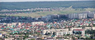
The area of the modern city is just under 30 square meters. km, more than 40 thousand people live in it. The satellite map of Pechora clearly shows that the city, based on two separate settlements, is still characterized by uneven urban development (no more than 31% of the land is built up). The reason is a large swampy lowland located within the city limits - a place of annual flooding.
Until the 70s. last century, Pechora was built up with small one- and two-story buildings, which were then replaced by five- and nine-story buildings.
Pechora has its own ice palace, sports school and art school, several cultural centers, as well as 25 clubs and more than 20 libraries throughout the area, its own industrial and economic college, and a branch of the State St. Petersburg University of Water Communications has been opened.
Pechora-Ilychsky Reserve
The largest in Europe and the first biosphere reserve in Russia. This is how we can briefly describe the Pechora-Ilychsky Nature Reserve. Its untouched nature has made it part of the UNESCO World Heritage Site.
The reserve is located at the junction of the Russian Plain and the Ural mountain range. This explains the climatic variations as well as the diversity of flora and fauna. Conventionally, it is divided into three districts.
We recommend reading: The Kan River on the map of the Krasnoyarsk Territory, rafting and fishing
Manpupuner stone pillars
Main attractions:
- Mountain of idols. Seven stone pillars on the Manpupuner plateau. Their height is from 30 to 42 meters. Formed over 200 million years of weathering.
- Plateau of Torre Porre Iz. The rocks are scattered so that they resemble an ancient city.
- Elk farm. Opened in 1949, it was intended for breeding domestic moose. They were used for meat and milk, and also as working animals. In addition to moose, the farm raised polar deer, camels and yaks.
There are 200 species of birds, 40 species of mammals in the reserve, and about 20 species of fish live in the rivers and lakes.
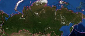
Pechora on the map of Russia: geography, nature and climate
The city is located on the Pechora Lowland (with a characteristic slightly hilly topography), along the right bank of the river of the same name. It is considered one of the greenest cities in the North - the area occupied by vegetation within the city is 28 hectares.
The climate is temperate continental with cold winters (average air temperature from -15°C to -18°C) and short, not very hot summers (+12°C – +16°C). From mid-May to the end of July is the time of white nights.
Due to the difficult climate, living conditions in the territories of the city and surrounding areas are equal to the conditions of the Far North.
Water regime and nutrition
The river is filled mainly with melted snow. The share of snow supply is 50% of the total annual runoff. The rest of the runoff comes from summer and autumn rains.
High water occurs in early April and late May. Sometimes it lasts until June. The greatest low water occurs in summer and winter. In summer it is interrupted by prolonged rains and floods.
The average water flow at the mouth is 4000 m/s. It freezes in October, and freeze-up continues until mid-spring. Ice break-up begins from the upper reaches and is accompanied by congestion on the riverbed.
Komsomolsk-on-Pechora
Routes on the map of Pechora. Transport infrastructure
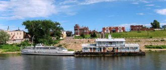
The city of Pechora has its own railway station (Komi Republic, Pechora, Privokzalnaya St., 3a), and the local “ Pechora River Shipping Company ” (Nikolai Ostrovsky St., 63B, Pechora) remains to this day one of the largest transport enterprises of the republic.
It has its own airport (42 Svobody St., Pechora), providing air communication with Syktyvkar.
Road transport communication is difficult, but construction is already underway on a large Ukhta-Naryan-Mar highway, which will pass through the territories of Pechora and Usinsk. In the meantime, car owners have to use the ferry services connecting Pechora and Vuktyl.
There are 6 municipal bus routes in the city itself. They can be found on the map of Pechora with streets (along the City Ring, from the railway station to: city hospital, airport, Vostochny village; from city hospital to: State District Power Plant, Gorky Square). Travel from Pechora, including to the villages of Naberezhny, Kozhva, Izyaya, Ozerny, Bely Yu, and the villages of Byzovaya, Ust-Kozhva, Medvezhskaya, Konetsbor, is provided by minibuses.
Development and economic use of the river
The river is navigable to Troitsko-Pechorsk. In spring and autumn, navigation is possible to Ust-Unya. Large sea vessels can sail a distance of 110 km from the mouth (to Naryan-Mar).
The Pechora basin is rich in minerals. There are deposits of coal, oil and natural gas. There are many settlements on the banks, whose residents engage in fishing.
Ust-Unya
Sights of the city of Pechora
One of the most important attractions of the city remains the State Museum of History and Local Lore and the exhibition “Repentance”, dedicated to compatriots - victims of political repression.
There are also monuments in the city:
- victims of Pechorlag;
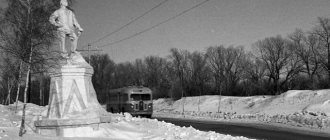
- V. Rusanov;
- geologists;
- S. Kirov;
- M. Gorky;
- MI-8 helicopter.
There are also parks here:
- Pinery;
- children's named after Volodya Dubinina;
- Pechorsky;
- and national "Yugyd Va".
A reminder of the years of the Second World War was the Enemy Landing Site - 12 former prisoners of war who were trained at a German intelligence school. Former Soviet soldiers, once on their land, chose to immediately surrender to the NKVD.
One of the main places where tourists who arrive in the city first come is the chapel installed in Pechora Park “In memory of the Russian New Martyrs ,” at the burial site of Gulag prisoners.
Pechora in culture
Eregina Yulia
I love the sea and taiga. I recently decided to take up journalism. I publish educational articles about natural objects and animals.
Ask a Question
An interesting legend associated with Pechora tells of ancient times. At that time, people called Chud lived along the banks. They built small settlements, engaged in cattle breeding, hunting, and fished during leisure hours. So the giant Yag-Mort appeared in those places at the confluence of Izhma and Pechora. He began to behave disgracefully: he would either start a fire, or drag away some cattle, or even covet someone’s wife. The latter completely infuriated hunters and fishermen. They all got together, sharpened their arrows and spears, and went to fight the bloodthirsty giant. Yag-Mort fought back for a long time, but collapsed exhausted. This is where they finished him off. They threw the giant into a hole and threw stones at him. From then on, everyone who passed by had to spit and throw a stone. Since then, the giant has been used to scare disobedient children and wives, and the legend was even published in the Vologda provincial news.
The local population honors the memory of their peoples and customs. Fairs, festivals and mass celebrations are held annually in Pechora settlements:
- “Seno” in Troitsko-Pechorsk;
- “Magicians of Pechora” in Pechora;
- “Power of the Arctic” in Naryan-Mar;
- “Rituals of the Komi Peoples” in the city of Vuktyl;
- "Gorka" in the village. Ust-Tsilma.
The spectacle is always colorful and exciting.
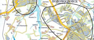
Main streets of Pechora
The main streets of the city are clearly visible on the map of Pechora with houses:
- st. Nikolai Ostrovsky - stretches from Pechora Avenue to the intersection with Lenin Street (here are: the park named after V. Dubinin, a monument to Gorky, the local history museum is located nearby);
- st. Zheleznodorozhnaya - stretches from Pristantsionnaya Street to the intersection with Lenin Street (the branch of Russian Railways OJSC Pechora Distance Central Station, the monument to M. Gorky, the publishing house "Vremya" are located);
- st. Lenina - one of the longest streets in the city - begins almost at the village of Abez and ends at the intersection with Energostroiteley Street (nearby is the historical district “Zheleznodorozhnaya Part”);
- st. Stadionnaya - from 8 March Street to Pribrezhnaya Street (location: Pechora Bogoroditsky Monastery and Lokomotiv Stadium);
- st. The Socialist one stretches from the Pechora embankment to Zheleznodorozhnaya Street (here is the forest park area along Chekhov Street, the historical territory “River Part” and the park “Sosnovy Bor”).
Fishing and hunting
Pechora is called “fishing paradise”. The water is inhabited by grayling, whitefish, pike, perch, ide, and burbot. Salmon comes to the river and its tributaries every year to spawn. Rafting on Pechora can be combined with a fishing tour. In fishing grounds you have the opportunity to purchase the necessary equipment and learn from professionals.
The spring hunting season in the Komi Republic begins at the end of April, beginning of May. This year you can hunt waterfowl from May 10; the season for upland game opens 5 days later. Geese are allowed to kill up to 2 males per day and ducks no more than 5 drakes, but you can shoot black grouse and wood grouse only one male per lek.
Wolves are freely shot, but a license is required to hunt bears. Hunting for game is allowed within certain periods.
Economy and industry of Pechora
Despite the fact that oil and gas fields have been discovered within the city (more than two dozen fields, where production is also carried out by enterprises), the main industry of Pechora remains the electric power industry. Five power units of the Pechora State District Power Plant provide one third of the republic’s electrical energy needs.
In addition, the territory of the district has become the site of such large oil and gas pipelines as Usinsk - Yaroslavl, Usinsk - Pechora, Yamal - Europe, etc. There are 6 large credit organizations operating in the city.
Where did the name come from?
The Nenets name for the river is Sanero'yakha. Mansi call the river Peserya. We open the Russian chronicles of 1906 and read that in the VI-X centuries. tribes of hunters lived on these lands and they were called Pechory/Pechory
. The remains of their settlements were found at the mouth of the river. It is believed that these people came from the White Sea coast. The language of communication was most likely ancient Sami.
Historical records also indicate that 200 years ago, in the settlement territory of modern Nenets, there were still spacious dwellings of the Pechers
.
What happened to them and where they disappeared is unclear. In the legends of the Nenets they remained as sikhirtya
or
sirtya
.
Although, if you rely on the dictionary of Maksimovich L.M. and Shchetakov A.M., then the Pechers were a Sarmatian people and got their name from the river. That is, Pechora was already Pechora before they appeared. The simplest option for the origin of a toponym is the abundance of caves in the lower reaches of the river. Most likely, in Old Russian the word “cave” sounded like this. Let's look at the Slavic brothers' translation of this word. Ukrainians have pechera, Belarusians have pyachora. Everything indicates that there was once one people, one ancestral language and one Pechora.
A river appeared along with the Stone Belt, as the mountains of the Urals were called in the old days.
Unusual sights of Pechory
Yes, these are not the most prominent objects in the city. You can easily walk past the Archer's House and simply not notice the Lantern Monument. But you shouldn't do this. On the contrary, pay attention to the sights that have survived to this day thanks to active citizens.
Sagittarius house
- Address - st. Verkhovicha, 4.
This is a real monument of wooden architecture. It was built at the beginning of the 18th century. It is a two-tier log house on a low stone foundation.
The unique building has survived to this day. At one time, archers lived in it, who, on the orders of Ivan the Terrible, protected the monastery from foreigners. Then a whole Streletskaya settlement formed around the holy place. But only one house survived to us.
Now it is in disrepair. A group of concerned people is fighting for recognition of this object as an architectural monument.
Monument to the street lamp
- Coordinates on the map are 57.813082, 27.612690.
This is a relatively young monument. It appeared in 2011. Forged according to artistic sketches by Pskov craftsmen. The street lamp rises over three meters in height. It is stylized as antique. There are two forged birds sitting on top of it. The object symbolizes light, comfort, kindness and love for one’s native places.
Holy Spring of John the Baptist
- Coordinates: 57.815750, 27.626000.
It is located not far from the famous monastery - in the place where the Kamenets stream flows into the Pachkovka river. The water in the source is unusually clean and tasty.
The stone Church of St. John the Baptist was built above this place in the 19th century. It is crowned with a tiny dome with a golden cross. There is a staircase leading from the building to the key.
According to legend, in ancient times there was an ancient temple on this site. During the attack of foreigners, he completely went underground, and in its place a holy spring began to flow.
Linnas-Selyun Farm
- Coordinates: 57.770108, 27.702554.
This is a cozy comfortable house in the forest. It provides everything for a relaxing holiday away from the noisy city. There is a cozy double bed in the room. There is a beautiful table and everything you need to serve it.
There is a barbecue in the yard. There is a small terrace adjacent to the house, which offers stunning views of the forest. The owner treats guests to excellent kvass made with birch sap. A warm welcome is guaranteed to every visitor.
Source, tributaries and channels
A river is born in the Ural mountains in their northern part. In the huge Pechora-Ilychsky Nature Reserve on the territory of the Komi Republic there is a stone with a cast iron tablet. The inscription says that the great northern river begins here.
Newborn Pechora is only 50 cm wide. After walking around the Komi lands, he looks into the Nenets Autonomous Okrug. There, dividing into Malaya and Bolshaya Pechora, it forms a delta more than 40 km wide and flows into Pechora Bay.
What kind of lip is this? This is part of the Pechora Sea, which in turn is part of the Barents Sea, and all together this is the diocese of the Father Ocean, the Arctic.
The river has 148 tributaries, with the same number of left and right. The main ones include:
- Value;
- Let's underscore;
- Tansy;
- Northern Mylva;
- Unya;
- Shapkina;
- Izhma;
- Yorsa;
- Kozhva;
- Kuya;
- Borovaya;
- Shchugor;
- Sozva;
- Tsilma;
- Ilych;
- Sub-daughter;
- Lemew;
- Barking;
- Neritsa;
- Ski, etc.
As for the channels from the river. There was one big idea. In 1933, pundits gathered at the Academy of Sciences for a conference and decided to dig a canal from Pechora to the Kama with access along the Volga to the Caspian Sea. The plans were most likely interrupted by the war.
They remembered him in the sixties, when Nikita Sergeevich showed character, Kuzka’s mother and demanded to turn the rivers back. “Dig a canal!” he shouted, slapping his shoe. One 100-kilometer canal to the Kama was not enough for him. They reassured us by promising another 62 km long Pechora-Vychegda.
It was decided to lay the canals using the method of nuclear explosions. They made the first three, after which a trench of 600 X 300 m was left. When it became clear that hundreds of such explosions were needed, the construction was immediately abandoned. The country started growing the queen of fields - corn, but everyone forgot about the canal.
What to see from museums in Pechory
There are several interesting museums in the city. Each of them demonstrates the history of the region and town in its own way. Here you can spend time on your own or with a guide with benefit and pleasure - both adults and children, especially schoolchildren.
City History Museum
- Address – International, 6.
It opened back in 1920. However, most of the exhibits were lost in the fire of war. In the middle of the last century, the collection began to take shape anew. The museum currently hosts several exhibitions. Some of them are aimed at demonstrating archaeological and ethnographic finds. Part is devoted to the study of the history of the USSR. There is an exhibition where ceramic and porcelain products are shown. Special attention is paid to fine arts.
Museum-Estate of the Seto People
- Address: Sigovo village.
Seto are a people who live on the border between Russia and Estonia. It has preserved its culture, traditions and mentality. The museum exposition is dedicated to this glorious ethnic group. The establishment is located on the territory of an old estate.
The complex includes a manor house, a barn, a barn and a bathhouse. Visitors can get acquainted with household items, costumes, furniture, and household utensils characteristic of Seto. The museum staff takes its guests into the fabulous world of legends, traditions and tales.
Flax Museum "Linen Province"
- Address - Rizhskaya st., 75B.
Created within the framework of the cultural and educational project “Linen Province”. This is a tribute to the past of the Pechora region, which once produced huge quantities of flax. The museum presents historical information about flax production in the Pskov region and stories about people who were involved in flax at one time or another.
Fascinating excursions are held here in the form of lively conversations. There are elements of theatrical performance. Those interested can familiarize themselves with the line of men's and women's linen clothing.
Bridges
Among all the crossings across the river, the railway bridge at the village of Kozhva stands out clearly. It was built in the pre-war years with great difficulties, in the form of frosts, impassable swamps near the river and other “joys”.
Pechora railway bridge
It is interesting that metal trusses intended for the Palace of the Soviets in the capital were used for the construction of the building. They planned to build a gigantic building 500 meters high with Lenin instead of a spire, but it didn’t work out. But the bridge turned out to be strategically important during the war.