Altai Territory was formed in 1937. It is a subject of the Russian Federation, part of the Siberian Federal District. The total population is 2,332,511 people, half of them live in urban areas.
Among the population there are a total of about 30 nationalities, the majority are Russian-speaking, there are many representatives of German and Ukrainian nationality. An increase in natural population growth due to the birth rate has been observed since 2007, but the growth still remains at a low level. The reason is the move of many Altaians to big cities, where they can find better jobs and improve their careers.
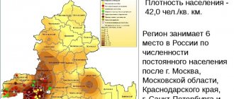
The density in the Altai Territory is low, only 14.28 people per km². The unemployment rate is quite low at 2%. The main economic direction of the entire region is agriculture. Many jobs are created and small businesses are supported. Despite this, wages here are not high.
Content
- 1 Largest cities 500 thousand - 1 million people 1.1 Barnaul
- 2.1 Biysk
- 3.1 Novoaltaysk
- 4.1 Yarovoe
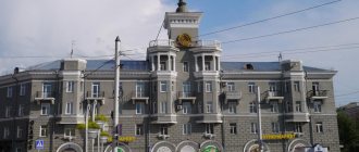
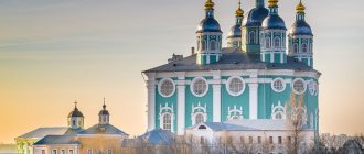
Barnaul is the largest city in the region
Barnaul is located on the left bank of the Ob River. 27% of the population of the entire region is concentrated here. In 2009, natural growth was observed for the first time in many years. More than 89% of the residents are Russian-speaking; other nationalities also live in Barnaul:
- Germans;
- Ukrainians;
- Tatars;
- Armenians;
- Belarusians.
Today, the main increase in population growth is due to incoming young people who arrive in Barnaul to study from small towns, villages, and villages. The city has institutes, academies, and universities.
Wages here are low, but prices for food and utilities are high. This is why some people work two jobs, while others leave their native Barnaul in search of higher salaries. Local residents work in factories and in trade. It doesn’t matter what the environmental situation is because of industry; some rivers are polluted.
There are many religious communities in this city; the highest percentage of Barnaul residents consider themselves Orthodox. There are Lutheran, Catholic, and Muslim communities here.
Urban settlements
- Southern
Population 19,693 (2020).
- Talmenka
Population 18,933 (2020).
- Siberian
Population 12,142 (2020).
- Blagoveshchenka
Population 11,390 people (2020).
- Steppe Lake
Population 6,262 (2020).
- Raspberry Lake
Population 2,952 (2020).
Rubtsovsk is a former mechanical engineering center
Among the Altai steppes, on the left bank of the Alei River stands Rubtsovsk. It used to be a major mechanical engineering center, before the collapse of the USSR. It is the administrative center of the Rubtsovsky district, which it is not part of. The name of the city was given in honor of the peasant Mikhail Rubtsov, who was a migrant. Until 1991, the local population grew, but then gradually began to decline, a problem that continues here to this day. Gradually, by 2009, natural population growth began to increase. The number of inhabitants is decreasing, but not as much as before.
The main reasons why people leave are the lack of jobs and low wages, although specialists are always welcome at enterprises and they can receive decent pay for good, qualified work. Local residents of Rubtsovsk work at local factories, industrial enterprises, and in trade. Since 2009, there has been an increase in migrants from villages and small towns. People come to get a job and study. Many remain permanently. The number of marriages has increased and there are fewer divorces, which is also very encouraging.
see also
- Altai region
- Symbols and sights of the Altai Territory
- Cities of Russia
| [ + ] Cities by regions of Russia | |
| Cities of the North-West (NWFD) | St. Petersburg (and its cities) • Leningrad region (historical Staraya Ladoga) • Arkhangelsk region • Vologda region • Kaliningrad region • Karelia • Komi • Murmansk region • Nenets Autonomous Okrug • Pskov region |
| Cities of the Volga region (Volga Federal District) | Bashkortostan • Volgograd region • Kalmykia • Kirov region • Mari El • Mordovia • Nizhny Novgorod region • Orenburg region • Penza region • Perm region • Samara region • Saratov region • Tatarstan • Udmurtia • Ulyanovsk region • Chuvashia |
| Cities of Southern Russia (SFD) | Sevastopol (including Inkerman) • Republic of Crimea • Adygea • Astrakhan region • Krasnodar region • Rostov region |
| Cities of the North Caucasus (NCFD) | Dagestan • Ingushetia • Kabardino-Balkaria • Karachay-Cherkessia • North Ossetia - Alania • Stavropol Territory • Chechen Republic |
| Cities of the Urals (Ural Federal District) | Kurgan region • Sverdlovsk region • Tyumen region • Khanty-Mansi Autonomous Okrug - Yugra • Chelyabinsk region • Yamalo-Nenets Autonomous Okrug |
| Cities of Siberia (Siberian Federal District) | Altai Republic • Altai Territory • Irkutsk Region • Kemerovo Region • Krasnoyarsk Region • Novgorod Region • Novosibirsk Region • Omsk Region • Tomsk Region • Tyva • Khakassia |
| Cities of the Far East (FEFD) | Amur Region • Buryatia • Jewish Autonomous Region • Trans-Baikal Territory • Kamchatka Territory • Magadan Region • Primorsky Territory • Sakha (Yakutia) • Sakhalin Region • Khabarovsk Territory • Chukotka Autonomous Region |
| see also | Cities of the DPR, LPR, Transnistria, South Ossetia • Regions of Russia • Cities of Russia |
Biysk is the cultural center of the Altai Territory
Biysk is a city of regional significance. An important scientific and industrial center of the entire Southern Siberia, as well as a cultural and educational center of the region, is located here. In terms of population, Biysk is in second place. It is located on the Biya River, in the southeast of the Altai Territory. More than 200,000 people live here, and the population is constantly growing. People come here from villages and towns, people consider Biysk calm and promising, get a job, and later stay. There are many people who go to work in large urban areas in Russia and abroad.
The economy is based on local enterprises that employ city residents. Marketers, engineers, and technologists are valued here, and the salaries of good specialists are decent. It is more difficult for women to get a job; they mostly work in the trade sector. Things are going well with education, there are several universities in Biysk, there are colleges, including medical and polytechnic, there are technical schools and gymnasiums.
The local ecology cannot be called good; this is a significant disadvantage for the local population. The timber mill located in Biysk and local residents pollute the rivers. Swimming in local waters is prohibited.
Novoaltaysk - a city of a better future
Novoaltaisk is located on the right bank of the Ob River. The city is divided into two banks by the Chesnokovka River. City status was assigned to Novoaltaysk only in 1942. Local residents love their hometown very much for its stunning nature, cozy and beautiful streets. In terms of living standards, Novoaltaysk even surpassed Barnaul and was recognized as the most comfortable place to live in the entire Altai Territory. More than 70,000 people live in Novoaltaysk in the period from 2006 to 2012. there was a population decline.
Today it is a city of young and talented. Local authorities pay a lot of attention to the development of youth and their future. Residents have museums, a cultural center, entertainment facilities, and children and students receive a good education. Everything is aimed at ensuring that people do not leave their native lands and stay to work here.
The economy of Novoaltaysk is developing due to its proximity to Barnaul. It is connected with this city by cultural, economic and industrial ties. The developed industrial sector and good geographical location make it an important railway junction in the Altai Territory.
The ecological situation is not very favorable, local rivers are polluted, engineering structures have been built on the banks, and rubbish heaps are not uncommon on the city outskirts. This negatively affects the quality of the local ecology.
Slavgorod: a city next to the pink lake
The city of Slavgorod (Altai Territory) was formed only at the beginning of the twentieth century. It has a surprisingly harmonious layout, this is due to the lands on which it is built. The steppe gave great opportunities to the builders, because they were able to build a city that was symmetrical and geometrically correct.
Slavgorod is surrounded on all sides by lakes, most of them salty. Scientists attribute this fact to groundwater and chemical elements in the soil. Two large lakes, Maloe Yarovoe and Bolshoye Yarovoye, have a supply of healing mud and do not freeze even in severe frosts.
Burlinskoye Lake, which is part of the territorial borders of Slavgorod, presents an incredible and fabulous picture - its shores are bright pink, and the water itself at times takes on a deep crimson hue. This is due to the large salt deposits covering the bottom of the lake. It has been mined here since time immemorial.
Each city in the Altai Territory is good in its own way, so when you come to these blessed lands, visit at least one of them. And you will immediately be imbued with the spirit and energy of these ancient mysterious places that make people happier.
Cities and resorts of Altai
Cities and resorts of Altai: Manzherok, Belokurikha, Altai Territory, Zavyalovo, Gorny Altai, Maiminsky district. What places are worth visiting in Altai.
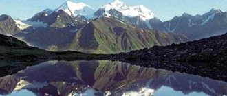
Many experienced travelers and outdoor enthusiasts compare Altai to the Alps. And this is no coincidence! Holidays in Altai in 2022 are an exciting journey to the land of real alpine meadows, clear springs and noisy rivers, mysterious caves and high mountains with peaks shrouded in centuries-old snow. Altai depicted in the photo can only partially convey the beauty that awaits guests of this region! Altai is a successful neighborhood of all possible types of vegetation (from swampy tundra...
- Altai Territory The Altai Territory is located in the south-eastern part of Western Siberia on the border with Asia and almost 3.5 thousand km from the capital of Russia - Moscow. The region is embraced by two regions - Novosibirsk in the north and Kemerovo in the east - and two Republics - Kazakhstan in the west and Altai in the southeast. Occupied area: 168 thousand km²
- Belokurikha The Belokurikha resort offers ski lovers several slopes located on Mount Tserkovka and Yakovka. The resort town of Belokurikha is located among the northern spurs of the Cherginsky ridge, at an altitude of about 250 m above sea level in the Altai Territory.
- Turquoise Katun Tourist and recreational zone "Turjuzovaya Katun" is located in the Altai Territory on the left bank of the Katun near the village of Manzherok, 270 km from Barnaul, 35 km from Gorno-Altaisk. It emerged on February 3, 2007 by order of the Russian government. The goal was to promote ecotourism and wellness. Area: 3326 hectares.
- Mountain Altai The Altai Republic thrives in central Asia, touching the Siberian taiga, green steppes and hot semi-deserts. “Russian Tibet,” as it is also called, is located not only at the junction of several natural zones, but also among the cultural worlds of countries such as China, Mongolia, Russia, and Kazakhstan. The occupied area is about 90 thousand km². The population is over 200 thousand people...
- Mountain Charysh Put together an orderly series of mountain ranges, add to them dense forests, picturesque valleys and river banks - the result will be Mountain Charysh. This mountainous and taiga zone is located in the Altai Territory, covering the interfluve of Anui and Charysh.
- Zavyalovo The resort area of Zavyalovo occupies a special place in the tourism market and in the hearts of Siberians, being considered one of the popular health resorts of the Altai Territory
- Kosh-Agachsky district The Kosh-Agachsky district is the largest by territorial standards in the Altai Republic. The region borders Tyva, Mongolia, China and Kazakhstan.
- Maiminsky District The smallest and most densely populated region of the Altai Republic is called Maiminsky.
- Manzherok In the picturesque Altai Republic there is one very wonderful place - Manzherok. It’s not difficult to find – more than 40 kilometers from Gorno-Altaisk and you’re there.
- Lake Aya Just 19 kilometers from Gorno-Altaisk there is one of the most famous lakes in Siberia - Aya. To spend your holiday on Lake Aya it is not necessary to have a week or two left. Many people come here for the week-end, and then go to work on Monday with renewed vigor.
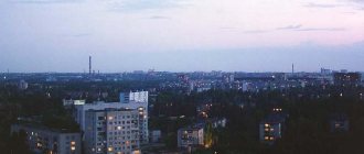
Barnaul is the gas-polluted administrative center of the Altai Territory with a population of 629,681 people. Unofficially founded in the Stone Age, as evidenced by numerous archaeological finds. Officially, in 1730, on the site of modern Barnaul, the miner Akinfiy Demidov appeared with two hundred peasants to lay out the plant and, in fact, founded it.
Central square of Barnaul
Even during World War II, Barnaul began to transform from an agricultural town into a powerful industrial center of Siberia, and the post-war economic development only strengthened this status.
Industry has greatly influenced the deterioration of the ecology of the entire Altai Territory. What's the first thing that comes to mind when you mention Altai? Endless mountain ranges, the song “Oh, frost, frost” echoing in the crystal clear air, Zolotukhin smelling a flower...
One of the many shopping centers in Barnaul - City Center
But in reality everything is much sadder. And Zolotukhin did not smell flowers in Altai, and emissions from the heavy and chemical industries led to the birth of a smoky oasis, Barnaul, in the middle of the purest Siberian expanses. Where you can literally see what you are breathing, and where staying for a long time without a gas mask is just as not recommended for health as breathing deeply in Moscow on the street in the middle of rush hour.
Barnaul is a fairly developed city in terms of transport, shopping centers, catering places, and shopping and entertainment centers. By the way, there is even an airport 17 km from Barnaul.
Biysk was built by decree of Peter 1 as an important outpost in the defensive border line from Kuznetsk to Ust-Kamenogorsk; in 2009 it celebrated its tricentenary. This is the gateway city to the Altai Mountains. All mountain tourist routes start from here. The famous Chuysky tract, which connects Russia and Mongolia with a trade highway, originates in Biysk. Biysk is a kind of cultural capital of the Altai region, its science city.
Letniy Biysk
The city is home to four higher educational institutions and many colleges that provide vocational education. The city also has more than 15 libraries, a local history museum, a City Drama Theatre, and several clubs and leisure centers for young people. On the territory of Biysk there are more than 272 architectural monuments, 50 archaeological monuments and 11 natural monuments. And therefore it is proud to be a member of the Union of Historical Cities of Russia.
One of the main architectural attractions is the Biysk Drama Theater
The main types of transport in Biysk are buses, trams and minibuses, and there is also a cargo airport in the city.
Rubtsovsk is a small village founded by Mikhail Rubtsov in 1886, transformed into a station village in 1913, and received city status in 1927. The third largest city in the Altai Territory with a population of 145,834 people.
Just like in Barnaul, many industrial enterprises were evacuated to Rubtsovsk during the Great Patriotic War, gradually turning it into the industrial center of the south-west of the Altai Territory. True, with the collapse of the USSR, many enterprises simply went bankrupt, sending the city’s economy into severe decline.
But this does not prevent residents from developing and becoming spiritually enriched: the city has three universities, several vocational schools, and even two theaters and an art gallery.
Judging by the information from the city administration, residents are terribly fond of amateur performances, and therefore, against the backdrop of the general decline of the economy, there are many VIAs, creative groups, and original performers. In general, from Alpha to Omega, from playing the spoons to the harpsichord and organ.
The ecology of the city is severely disturbed due to waste emissions from enterprises, and the close proximity of the nuclear test sites of Semipalatinsk generally makes one seriously think about a long stay in this city without a Geiger counter.
Barnaul is the largest city in the region
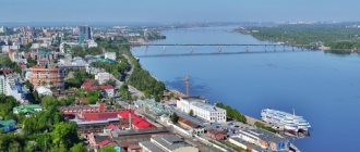
It is located at the confluence of the Barnaulka River and the Ob. Distance to Moscow – 3000 km, to Novosibirsk – 230 km, to Gorno-Altaisk – 250 km. The following highways pass through the city:
- R-256 “Chuysky Trakt” (from Novosibirsk to the border with Mongolia via Biysk and Gorno-Altaisk);
- A-322 “Zmeinogorsky tract” (via Rubtsovsk to Kazakhstan);
- “Pavlovsky tract” (01K-02, Pavlovsk - Kamen-on-Obi - Novosibirsk region);
- bypass road (Lentochny Bor highway);
- “Right Bank Tract” (across the new bridge on R-256).
Barnaul is a large station on the West Siberian Railway. From the international airport named after G.S. Titov (BAX/UNBB) operates regular flights to Moscow, St. Petersburg, Tomsk, Kazan, Irkutsk, Krasnoyarsk, Antalya, Cam Ranh. The river port offers regular, pleasure and cruise routes along the Ob water area, including the Arctic Circle (to Salekhard, Yamalo-Nenets Autonomous Okrug).
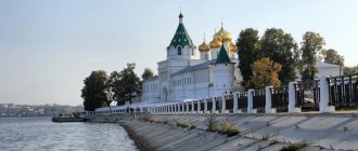
The historical part of the capital of the Altai Territory has distinctive architecture. Many projects were implemented by students of Quarenghi and Rossi, who gave St. Petersburg its extraordinary appearance. Among the most interesting ancient monuments and attractions are:
- Complex "Nagorny Park".
- Lenin Avenue (from Stroiteley Street in the direction of the river station).
- House of the merchant Poskotinov.
- Znamensky Convent.
- Open-air museum "Silver Smelter".
- Barnaul Planetarium.
- Petting zoo "Forest Fairy Tale".
- Museum "World of Time".
- Arboretum of the Research Institute named after. M.A. Lisavenko.
- St. John the Theologian Church.
- “Mountain Pharmacy” (museum exhibitions, restaurant, pharmacy).
- Embankment in Nagorny Park.
The list of educational and tourist sites that are a must when visiting Barnaul includes the Altai State Museum of Local Lore with a large number of diverse exhibitions.
Barnaul is located on the left bank of the Ob River. 27% of the population of the entire region is concentrated here. In 2009, natural growth was observed for the first time in many years. More than 89% of the residents are Russian-speaking; other nationalities also live in Barnaul:
- Germans;
- Ukrainians;
- Tatars;
- Armenians;
- Belarusians.
Today, the main increase in population growth is due to incoming young people who arrive in Barnaul to study from small towns, villages, and villages. The city has institutes, academies, and universities.
Wages here are low, but prices for food and utilities are high. This is why some people work two jobs, while others leave their native Barnaul in search of higher salaries. Local residents work in factories and in trade. It doesn’t matter what the environmental situation is because of industry; some rivers are polluted.
There are many religious communities in this city; the highest percentage of Barnaul residents consider themselves Orthodox. There are Lutheran, Catholic, and Muslim communities here.
Biysk is the cultural center of the Altai Territory
The second largest city in the region. Located near the source of the Ob (the confluence of the Biya and Katun). It has the status of a science city. The southernmost railway station, closest to Gorno-Altaisk and the airport in Mayma. Historically, it is the starting point of the Chuisky tract, which connects the region with the Altai Republic and the border of Mongolia. Also, important highways to Novokuznetsk, to Aktash and Lake Teletskoe (“Soltonsky tract”), and to Belokurikha pass through Biysk.
Where to stay in Biysk for the night:
Sights and iconic places:
- MBU "Rodina" (exhibition of rocket and space technology, planetarium, observatory).
- Church of Demetrius of Rostov.
- Museums – local history, “Weddings”, “Clocks”, “Chuysky tract”, “Ethnic culture of Altai”.
- Assumption Cathedral.
- Cannons of the Biysk fortress.
- Mansion of merchant Vasenev.
Alexander Park with its memorial wall of the Romanov royal dynasty is of constant interest to tourists.
Biysk is a city of regional significance. An important scientific and industrial center of the entire Southern Siberia, as well as a cultural and educational center of the region, is located here. In terms of population, Biysk is in second place. It is located on the Biya River, in the southeast of the Altai Territory. More than 200,000 people live here, and the population is constantly growing. People come here from villages and towns, people consider Biysk calm and promising, get a job, and later stay. There are many people who go to work in large urban areas in Russia and abroad.
The economy is based on local enterprises that employ city residents. Marketers, engineers, and technologists are valued here, and the salaries of good specialists are decent. It is more difficult for women to get a job; they mostly work in the trade sector. Things are going well with education, there are several universities in Biysk, there are colleges, including medical and polytechnic, there are technical schools and gymnasiums.
The local ecology cannot be called good; this is a significant disadvantage for the local population. The timber mill located in Biysk and local residents pollute the rivers. Swimming in local waters is prohibited.
Rubtsovsk is a former mechanical engineering center
Among the Altai steppes, on the left bank of the Alei River stands Rubtsovsk. It used to be a major mechanical engineering center, before the collapse of the USSR. It is the administrative center of the Rubtsovsky district, which it is not part of. The name of the city was given in honor of the peasant Mikhail Rubtsov, who was a migrant. Until 1991, the local population grew, but then gradually began to decline, a problem that continues here to this day. Gradually, by 2009, natural population growth began to increase. The number of inhabitants is decreasing, but not as much as before.
The main reasons why people leave are the lack of jobs and low wages, although specialists are always welcome at enterprises and they can receive decent pay for good, qualified work. Local residents of Rubtsovsk work at local factories, industrial enterprises, and in trade. Since 2009, there has been an increase in migrants from villages and small towns. People come to get a job and study. Many remain permanently. The number of marriages has increased and there are fewer divorces, which is also very encouraging.
Novoaltaysk - a city of a better future
Novoaltaisk is located on the right bank of the Ob River. The city is divided into two banks by the Chesnokovka River. City status was assigned to Novoaltaysk only in 1942. Local residents love their hometown very much for its stunning nature, cozy and beautiful streets. In terms of living standards, Novoaltaysk even surpassed Barnaul and was recognized as the most comfortable place to live in the entire Altai Territory. More than 70,000 people live in Novoaltaysk in the period from 2006 to 2012. there was a population decline.
Today it is a city of young and talented. Local authorities pay a lot of attention to the development of youth and their future. Residents have museums, a cultural center, entertainment facilities, and children and students receive a good education. Everything is aimed at ensuring that people do not leave their native lands and stay to work here.
The economy of Novoaltaysk is developing due to its proximity to Barnaul. It is connected with this city by cultural, economic and industrial ties. The developed industrial sector and good geographical location make it an important railway junction in the Altai Territory.
The ecological situation is not very favorable, local rivers are polluted, engineering structures have been built on the banks, and rubbish heaps are not uncommon on the city outskirts. This negatively affects the quality of the local ecology.
Zarinsk is a cozy and calm city
Zarinsk is a beautiful city, there are interesting sights here, and a large city-forming enterprise. Formed in 1979 after the merger of the village of Zarinsky and the regional center of the village of Sorokin. The city stands on the Chumysh River, not far from Barnaul. The population has been steadily decreasing over the past 20 years, young people are leaving their native Zarinsk and moving to large cities to build a career. The Altai-koks enterprise is the largest in the city, employing more than 3,000 people. 70% of all products go to Europe and Asia.
Located 100 km northeast of Barnaul on the banks of the Chumysh (Biysk-Chumysh Upland). It is a station on the West Siberian Railway. The main road transport line is the Zarinsky Trakt (01K-15), which in the west connects to the P-256 Chuysky Trakt highway, and in the east through 01K-14 (Martynovo - Togul - Zalesovo) it is connected to the Altai - Kuzbass highway. (01K-04), going to the Kemerovo region. Tourist sites:
- Cave temple complex with an altar room (the length of the passages is over 250 m);
- Ascension Church.
- Salair Ridge (watershed between Tom and Chumysh).
- Zarinsky Museum of Local Lore.
- Square with a milepost (in memory of the Catherine Route).
A popular place for unique selfies is the DZ-6 grader monument, which was produced in the 1950s according to pre-war documentation (GPS coordinates 53.743643, 84.912597).
Sources
- https://nesiditsa.ru/region/altayskiy-kray
- https://gdealtai.ru/altajskij-kraj/goroda/
- https://turizm.ngs.ru/altai/resorts/
- https://travelask.ru/articles/goroda-altayskogo-kraya-po-chislennosti-naseleniya